
The San Francisco Peninsula is a peninsula in the San Francisco Bay Area that separates San Francisco Bay from the Pacific Ocean. On its northern tip is the City and County of San Francisco. Its southern base is in northern Santa Clara County, including the cities of Sunnyvale, Palo Alto, Mountain View, and Los Altos. Most of the Peninsula is occupied by San Mateo County, between San Francisco and Santa Clara counties, and including the cities and towns of Atherton, Belmont, Brisbane, Burlingame, Colma, Daly City, East Palo Alto, El Granada, Foster City, Hillsborough, Half Moon Bay, La Honda, Loma Mar, Los Altos, Menlo Park, Millbrae, Mountain View, Pacifica, Palo Alto, Pescadero, Portola Valley, Redwood City, San Bruno, San Carlos, San Mateo, South San Francisco, Sunnyvale, and Woodside.

San Mateo County, officially the County of San Mateo, is a county located in the U.S. state of California. As of the 2010 census, the population was 718,451. The county seat is Redwood City. San Mateo County is included in the San Francisco-Oakland-Berkeley, CA MSA, Silicon Valley, and is part of the San Francisco Bay Area, the nine counties bordering San Francisco Bay. It covers most of the San Francisco Peninsula. San Francisco International Airport is located at the northern end of the county. The county's built-up areas are mostly suburban with some areas being very urban, and are home to several corporate campuses.

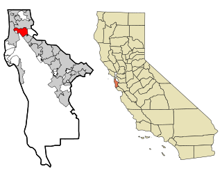
Daly City is the most populous city in San Mateo County, California, United States, with an estimated 2019 population of 106,280. Located in the San Francisco Bay Area, and immediately south of San Francisco, it is named for businessman and landowner John Donald Daly.
San Bruno is a city in San Mateo County, California, United States, incorporated in 1914. The population was 41,114 at the 2010 United States Census. The city is between South San Francisco and Millbrae, adjacent to San Francisco International Airport and Golden Gate National Cemetery, and is approximately 12 miles (19 km) south of downtown San Francisco.

San Mateo is a city in San Mateo County, California, about 20 miles (32 km) south of San Francisco and 31 miles (50 km) northwest of San Jose. San Mateo had an estimated 2019 population of 104,430. It has a Mediterranean climate, and is known for its rich history. The biggest economic contributors to the city include the Medical Center, one of the local school districts, and Sony's Sony Interactive Entertainment division. Finally, being in the center of the San Francisco Bay Area, it has many ways to travel between the major cities of that area.
Interstate 280 (I-280) is a 57.5-mile-long (92.5 km) major north–south auxiliary Interstate Highway in the San Francisco Bay Area of Northern California. It runs from I-680 and US 101 in San Jose to King and Fifth Streets in San Francisco, running just to the west of the larger cities of San Francisco Peninsula for most of its route.

Fitzgerald Marine Reserve is a marine reserve in California on the Pacific Ocean, located just north of Pillar Point Harbor and Mavericks in the San Mateo County community of Moss Beach. Moss Beach is located approximately 20 miles (32 km) south of San Francisco and 50 miles (80 km) north of Santa Cruz. The reserve is a 32-acre (0.13 km2) holding which extends from Montara light station at the north to Pillar Point on the south. The reserve consists of a three-mile stretch of beach, tidepool habitat, marsh, erosive bluffs, clifftop trail and cypress and eucalyptus forests. The property is owned by the State of California and managed by San Mateo County as a county park and nature preserve. The reserve is administratively assigned to be part of the Monterey Bay National Marine Sanctuary. Adjacent to and possibly within the reserve is an endangered species of butterfly, the San Bruno elfin butterfly.

The Bay Area Ridge Trail is a planned 550-mile (890 km) multi-use trail along the hill and mountain ridgelines ringing the San Francisco Bay Area, in Northern California. Currently 390 miles (630 km) have been established. When complete, the trail will connect over 75 parks and open spaces. The trail is being designed to provide access for hikers, runners, mountain bicyclists, and equestrians. It will be accessible through trailheads near major population centers, while the trail will extend into more remote areas. The first trail section was dedicated on May 13, 1989.

State Route 35, generally known as Skyline Boulevard for most of its length, is a mostly two-lane state highway in the U.S. state of California. It runs along the ridge of the Santa Cruz Mountains from the low point of State Route 17 near Lexington Reservoir in Santa Clara County to State Route 1 just south of Daly City in San Mateo County, where it crosses SR 1 and loops around Lake Merced to become Sloat Boulevard in San Francisco. SR 35 then continues along Sloat Boulevard until it reaches its terminus when it meets SR 1 again at 19th Avenue.

Coyote Point Recreation Area is a 670-acre (270 ha) park in San Mateo County, California, United States. Located on San Francisco Bay, it is south of San Francisco International Airport on the border of Burlingame and San Mateo.

Milagra Ridge is a 275-acre (111 ha) open space park that is an isolated island ecosystem, located about 7 miles (11 km) south of San Francisco, between the cities of Pacifica and Daly City. It was first inhabited by the Ohlone indigenous people, and was later claimed by Spanish settlers and Mexican ranchers.

San Bruno Mountain is located in northern San Mateo County, California, with some slopes of the mountain crossing over into southern San Francisco. Most of the mountain lies within the 2,326-acre (941 ha) San Bruno Mountain State Park. Next to the state park is the 83-acre (34 ha) state San Bruno Mountain Ecological Reserve on the north slope. It is near the southern boundary of San Francisco, surrounded by the cities of South San Francisco, Daly City, Colma, and Brisbane.
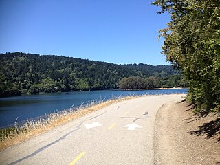
Sawyer Camp Trail is a popular 6-mile (9.7 km) trail located in the San Andreas Fault rift valley in San Mateo County, California near Hillsborough and the San Mateo Highlands. Officially, it is a segment of the longer Crystal Springs Regional Trail. Approximately 300,000 people use the trail every year. It provides excellent views of San Francisco Peninsula's Crystal Springs Watershed. The trail is managed by San Mateo County and totally surfaced in asphalt. There is considerable biodiversity along the trail due to the variation in habitat and the presence of serpentine soils. In particular the plant communities of Northern coastal scrub, grassland and California oak woodland are present.
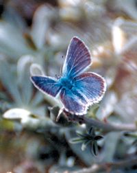
The Mission blue is a blue or lycaenid butterfly subspecies native to the San Francisco Bay Area of the United States. The butterfly has been declared as endangered by the US federal government. It is a subspecies of Boisduval's blue.

Montara Mountain, positioned between the unincorporated community of Montara, California, to the southwest and the city of Pacifica, California, to the north, forms the northern spur of the Santa Cruz Mountains, a narrow mountain range running the length of the San Francisco Peninsula that separates San Francisco Bay from the Pacific Ocean. Its highest point rises to 1,898 feet (579 m) above sea level. An unpaved fire road, the North Peak Access Road, accessible from the Pedro Mountain Road in McNee Ranch State Park, provides access to the summit by hikers from the south. From the north, Montara Mountain Trail, Hazelnut Trail and Brooks Creek Trail provide access to the mountain with trailheads in San Pedro Valley County Park.
One of the six Boy Scouts of America councils that serves the San Francisco Bay area, the Pacific Skyline Council was founded in 1940 as the Stanford Area Council (#031). In 1994, the Stanford Area Council merged with the San Mateo County Council (#020) to form the current council which serves youth in San Mateo County and northern Santa Clara county.
Guadalupe Creek or Guadalupe Valley Creek is a short eastward-flowing stream whose watershed originates just east of the highest peak of San Bruno Mountain in San Mateo County, California, United States. It courses through San Bruno Mountain State and County Park and Brisbane before entering the Brisbane Lagoon.

The Bay checkerspot is a butterfly endemic to the San Francisco Bay region of the U.S. state of California. It is a federally threatened species, as a subspecies of Euphydryas editha.


