
Auburn State Recreation Area is a state park unit of California, along 40 miles (64 km) of the North and Middle Forks of the American River. The state recreation area (SRA) is situated on the border of Placer and El Dorado Counties in the heart of historic Gold Country. The largest city with close proximity is the city of Auburn. Once teeming with gold mining activity, the area now offers a wide variety of outdoor recreational opportunities. Major recreational uses include trail running, hiking, swimming, boating, fishing, camping, mountain biking, gold panning, horseback riding, road bicycling, and off-highway motorcycle riding. Whitewater recreation is also very popular on both forks of the river, with Class II, III and IV runs. Auburn SRA is also known as the location of a number of endurance races that are hosted throughout the year.

BRP Inc. is the holding company for Bombardier Recreational Products Inc., operating as BRP, a Canadian manufacturer of snowmobiles, all-terrain vehicles, side by sides, motorcycles, and personal watercraft. It was founded in 2003, when the Recreational Products Division of Bombardier Inc. was spun-off and sold to a group of investors consisting of Bain Capital, the Bombardier-Beaudoin family and the Caisse de dépôt et placement du Québec. Bombardier Inc., was founded in 1942 as L'Auto-Neige Bombardier Limitée by Joseph-Armand Bombardier at Valcourt in the Eastern Townships, Quebec.

Off-roading is the activity of driving or riding in a vehicle on unpaved surfaces such as sand, gravel, riverbeds, mud, snow, rocks, and other natural terrain. Types of off-roading range in intensity, from leisure drives with unmodified vehicles, to competitions with customised vehicles and professional drivers. Off-roaders have been met with criticism for the environmental damage caused by their vehicles. There have also been extensive debates over the role of government in regulating the sport, including a Supreme Court case brought against the Bureau of Land Management in the United States.

The Francis Marion National Forest is located north of Charleston, South Carolina. It is named for revolutionary war hero Francis Marion, who was known to the British as the Swamp Fox. It lies entirely within the Middle Atlantic coastal forests ecoregion. The park is also entirely in the Subtropical coniferous forest.

Guadalupe-Nipomo Dunes is the largest remaining dune system south of San Francisco and the second largest in the U.S. state of California. It encompasses an 18-mile (29 km) stretch of coastline on the Central Coast of California and extends from southern San Luis Obispo County to northern Santa Barbara County.

The San Luis Reservoir is an artificial lake on San Luis Creek in the eastern slopes of the Diablo Range of Merced County, California, approximately 12 mi (19 km) west of Los Banos on State Route 152, which crosses Pacheco Pass and runs along its north shore. It is the fifth largest reservoir in California. The reservoir stores water taken from the San Joaquin-Sacramento River Delta. Water is pumped uphill into the reservoir from the O'Neill Forebay which is fed by the California Aqueduct and is released back into the forebay to continue downstream along the aqueduct as needed for farm irrigation and other uses. Depending on water levels, the reservoir is approximately nine miles (14 km) long from north to south at its longest point, and five miles (8 km) wide. At the eastern end of the reservoir is the San Luis Dam, the fourth largest embankment dam in the United States, which allows for a total capacity of 2,041,000 acre-feet (2,518,000 dam3). Pacheco State Park lies along its western shores.

Lincoln National Forest is a unit of the U.S. Forest Service located in southern New Mexico. Established by Presidential Proclamation in 1902 as the Lincoln Forest Reserve, the 1,103,897 acres (4,467.31 km2) forest begins near the Texas border and contains lands in parts of Chaves, Eddy, Lincoln, and Otero counties. The three Ranger Districts within the forest contain all or part of four mountain ranges, and include a variety of different environmental areas, from desert to heavily forested mountains and sub-alpine grasslands. Established to balance conservation, resource management, and recreation, the lands of the Lincoln National Forest include important local timber resources, protected wilderness areas, and popular recreation and winter sports areas. The forest headquarters is located in Alamogordo, N.M. with local offices in Carlsbad, Cloudcroft, and Ruidoso.

The McInnis Canyons National Conservation Area (MCNCA) is a 123,400-acre (499 km2) National Conservation Area located in Mesa County, west of Grand Junction, Colorado. The MCNCA has rugged sandstone canyons, natural arches, spires, and alcoves carved into the Colorado Plateau, through which runs a 24-mile (39 km) stretch of the Colorado River. Included in the MCNCA is the 75,500-acre (306 km2) Black Ridge Canyons Wilderness (BRCW) with 5,200 acres (21 km2) extending into eastern Grand County, Utah at the MCNCA's western boundary.

Ocotillo Wells is an unincorporated community in San Diego County, California, United States. It is 3 miles (4.8 km) west of the Imperial County line on California State Route 78 at an elevation of 163 feet (50 m). The name became official in 1962 when it was adopted for federal use by the US Board on Geographic Names. A federally recognized variant name, Ocotillo, can cause confusion with the community of Ocotillo, California in Imperial County, 29 mi (47 km) to the south on Interstate 8.

An amphibious all-terrain vehicle, amphibious ATV, is a small, all-wheel drive, all-terrain amphibious vehicle, used for recreation, farm-, hunting, utility or industry tasks, by enthusiasts and professionals worldwide. They are legally off-highway vehicles in many countries, or at least restricted from use on express highways and motorways – their use is generally extra-urban.

San Benito Mountain is the highest mountain in the Diablo Range of California. The summit is at an elevation of 5,267 feet (1,605 m). The rock is composed of asbestos (chrysotile), an ultramafic rock. It weathers to produce serpentine soils with characteristically low levels of nutrients like nitrogen, phosphorus, potassium, and calcium, and high levels of magnesium and heavy metals including nickel and chromium. This means little vegetation grows in the area though there are some plants that only grow on such soils like the local endemic San Benito evening primrose. The Clear Creek Management Area includes the San Benito Mountain Research Natural Area, recognized for its unique pine and incense cedar forest assemblage. The Mediterranean climate is punctuated by cool, wet winters and hot, dry summers.
Rasor Off-Highway Vehicle Area is a remote public use area for the off-highway vehicle user located in the Mojave Desert about 50 miles (80 km) east of Barstow, California, administered by the Bureau of Land Management.

Outdoor recreation or outdoor activity refers to recreation done outside, most commonly in natural settings. The activities that encompass outdoor recreation vary depending on the physical environment they are being carried out in. These activities can include fishing, hunting, backpacking, and horseback riding — and can be completed individually or collectively. Outdoor recreation is a broad concept that encompasses a varying range of activities and landscapes.
The California Desert Protection Act of 2010 was legislation proposed by U.S. Senator Dianne Feinstein. The stated aim of the legislation was "to provide for conservation, enhanced recreation opportunities, and development of renewable energy in the California Desert Conservation Area."
Jordan River Off-Highway Vehicle State Recreation Area is a Utah State Park located in Salt Lake City, Utah, USA. The park is dedicated to recreation with off highway vehicles. It consists of four separate tracks, with tabletops and banked turns, and is open from approximately early April to approximately mid-October. Off-highway motorcycle (OHM) riders have access to two motocross tracks. The novice and grand-prix tracks are open to both OHMs and all-terrain vehicles.
Corral Hollow, formed by Corral Hollow Creek, is a canyon partially located in Alameda County, with parts in San Joaquin County, 6.5 miles (10.5 km) southwest of Tracy, California. Corral Hollow Creek, formerly El Arroyo de los Buenos Ayres, from its source 1.9 miles (3.1 km) north of Mount Boardman, flows north 1.89 miles where it turns to flow west-northwest 8.5 miles (13.7 km) then turns abruptly east in the vicinity of Tesla to flow 5 miles (8.0 km) east where it turns again in a northeasterly direction for 6 miles (9.7 km) to the Delta-Mendota Canal in the San Joaquin Valley.
Carnegie was a town in Corral Hollow, in San Joaquin County, California from 1902 to about 1915.

Hungry Valley is a valley located along the northern border of Los Angeles and Ventura counties, about 2 mi (3.2 km) southwest of Gorman, California. The valley is notable for being a popular destination for off-road vehicle enthusiasts across California.
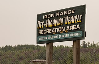
Iron Range Off-Highway Vehicle State Recreation Area is a State Park unit located east of Lake Ore-be-gone in Gilbert, Minnesota. The recreation area consists of 36 miles (58 km) of trails on a 1,864-acre (754 ha) unit, all of which was local iron ore mining land until 1981. A 3,500-acre (1,400 ha) expansion of the recreation area is also being planned, with land acquisition underway.

