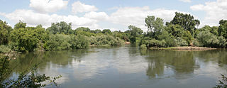
Admiral William Standley State Recreation Area is a state recreation area of California, United States, featuring 45 acres (18 ha) of redwoods on the Eel River. It is located 14 miles (23 km) west of Laytonville, California, in Mendocino County. The park is a popular spot for salmon and steelhead fishing and also attracts hikers and picnickers.

Andrew Molera State Park is a 4,800 acres (1,900 ha), relatively undeveloped state park on the Big Sur coast of California, United States, preserving land as requested by former owner Frances Molera. Situated at the mouth of the Big Sur River, the property was part of the Rancho El Sur land grant, and later owned by Californio pioneer John Bautista Rogers Cooper and his descendants. Cooper's grandchildren Andrew and Frances Molera inherited the property from their mother in 1918. Andrew popularized the artichoke in California in 1922, and died in 1931. In 1965, Frances sold the property to The Nature Conservancy, stipulating that the park to be created should be named for her brother.

California Citrus State Historic Park is an open-air museum in the state park system of California, United States, interpreting the historic cultural landscape of the citrus industry. The park’s museum exhibits and interpretive features share the story of the citrus industry's role in the history and development of Southern California, and is told through the experiences of the diverse migrant and immigrant groups who made it all possible. The California Citrus State Historic Park is in the city of Riverside in Riverside County, California, United States. The 248-acre (100 ha) park was established in 1993.

The Lewis and Clark National Historical Park, located in the vicinity of the mouth of the Columbia River, commemorates the Lewis and Clark Expedition. Administration of the park, which includes both federal and state lands, is a cooperative effort of the National Park Service and the states of Oregon and Washington. The National Historical Park was dedicated on November 12, 2004.
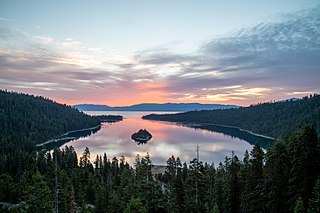
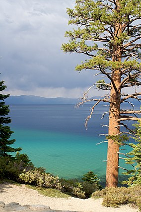
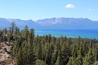
Emerald Bay State Park is a state park of California in the United States, centered on Lake Tahoe's Emerald Bay, a National Natural Landmark. Park features include Eagle Falls and Vikingsholm, a 38-room mansion that is considered one of the finest examples of Scandinavian architecture in the United States. The architect was Leonard Palme, who was hired by his aunt Laura Knight to design and build Vikingsholm. The park contains the only island in Lake Tahoe, Fannette Island. The park is accessible by California State Route 89 near the southwest shore of the lake. Emerald Bay is one of Lake Tahoe's most photographed and popular locations.

Del Norte Coast Redwoods State Park is a state park of California, United States, and a component of the Redwood National and State Parks. The property is about half old-growth forest of coast redwoods and includes 8 miles (13 km) of wild Pacific coastline. The park was significantly expanded in 2002 with the 25,000-acre (10,000 ha) Mill Creek Addition. Originally established in 1925, the park is now 31,261 acres (12,651 ha). The park was designated part of the California Coast Ranges International Biosphere Reserve in 1983.

The National Wilderness Preservation System (NWPS) of the United States protects federally managed wilderness areas designated for preservation in their natural condition. Activity on formally designated wilderness areas is coordinated by the National Wilderness Preservation System. Wilderness areas are managed by four federal land management agencies: the National Park Service, the U.S. Forest Service, the U.S. Fish and Wildlife Service, and the Bureau of Land Management.

Emeryville Crescent State Marine Reserve is a marine reserve of California, United States, preserving marshland on the east shore of San Francisco Bay. It is managed as part of Eastshore State Park by the East Bay Regional Park District. The 103.5-acre (41.9 ha) marsh stretches from the eastern approach of the San Francisco–Oakland Bay Bridge in Oakland to the foot of Powell Street in Emeryville. The reserve encompasses the entire Emeryville Crescent Marsh and is named as such for its crescent shape. It was established in 1985.

The California Coastal National Monument is located along the entire coastline of the U.S. state of California. This monument ensures the protection of all islets, reefs and rock outcroppings along the coast of California within 12 nautical miles (22 km) of shore along the entire 840-mile (1,350 km) long coastline. Conservative estimates are for at least 20,000 such outcroppings. The monument was created by Bill Clinton via Presidential proclamation on January 11, 2000, with the authority in section two of the Antiquities Act of 1906. As of 2014, the monument has expanded to 2,272 acres (919 ha). The U.S. Bureau of Land Management, an agency of the U.S. Department of the Interior that manages the monument, has developed gateways in cooperation with other agencies along the California coast to introduce the monument to the public. These include the Trinidad, Point Arena, Fort Bragg-Mendocino, Pigeon Point Lighthouse, Piedras Blancas State Marine Reserve and Marine Conservation Area, and the Palos Verdes Peninsula. Although being the most-viewed national monument in California, people are usually unaware that the entire coastline is a national monument.

Lake Tahoe–Nevada State Park is a state park comprising multiple management units and public recreation areas on the northeast shores of Lake Tahoe in the U.S. state of Nevada. The park covers approximately 14,301 acres (5,787 ha). The Marlette Lake Water System, which is listed on the National Register of Historic Places and as a National Historic Civil Engineering Landmark, lies within park boundaries.
Beartown State Forest is a publicly owned forest with recreational features located in the towns of Great Barrington, Monterey, Lee, and Tyringham, Massachusetts. The state forest's more than 10,000 acres (4,000 ha) include 198 acres (80 ha) of recreational parkland. It is managed by the Massachusetts Department of Conservation and Recreation.
Trail of Tears State Park is a public recreation area covering 3,415 acres (1,382 ha) bordering the Mississippi River in Cape Girardeau County, Missouri. The state park stands as a memorial to those Cherokee Native Americans who died on the Cherokee Trail of Tears. The park's interpretive center features exhibits about the Trail of Tears as well as displays and specimens of local wildlife. An archaeological site in the park was added to the National Register of Historic Places in 1970.

Cross Ranch State Park is a public recreation area covering 569 acres (230 ha) on the west bank of the Missouri River nine miles (14 km) south of Washburn in Oliver County, North Dakota. The Nature Conservancy's Cross Ranch Nature Preserve, a 6,000-acre (2,400 ha) preserve which features a roaming herd of more than 200 adult bison, lies adjacent to the state park.
Coquille Myrtle Grove State Natural Site is a state park administered by the Oregon Parks and Recreation Department in the U.S. state of Oregon. The park, bordering the Powers Highway between Myrtle Point and Powers, in Coos County, features a swimming hole and sandy beach along the South Fork Coquille River. Other amenities include parking, picnic tables, restrooms, and access to fishing but no drinking water.

Greenwood State Beach, also known as Elk Beach, is a state-protected beach of California, United States. It is located in the unincorporated village of Elk in Mendocino County. It is located about 15 miles (24 km) north of Point Arena on Highway 1. The 47-acre (19 ha) park was established in 1978.
Reynolds Wayside Campground is a state park in Mendocino County, California, United States. The site, which contained a redwood grove, was purchased by Frank W. Reynolds and his wife in 1928 and converted into a resort known as Reynolds Redwood Flat in 1930. After Mr. Reynolds died in 1962, the site was leased until the California state government purchased it in 1966 as a memorial to Reynolds and to protect it from logging. Under state management, 50 campsites were constructed at the site, which was renamed to Reynolds State Recreation Area before taking its present name. In 1976, the campsites were removed and the property was deemed surplus the next year. Much of the site's land was exchanged with a timber company for territory at Sinkyone Wilderness State Park in 1984. As of May 2021, Reynolds Wayside Campground contains 38 acres (15 ha) of land, including area for hiking and access to the Eel River.
Caswell Memorial State Park is a state park of California, United States, preserving a riparian forest along the Stanislaus River. It is located in southern San Joaquin County southwest of the town of Ripon. Riparian Oak Woodland, located in this park, is threatened and the park is trying to protect it. It once flourished through California's Central Valley. Caswell is also the home to several endangered species. The 258-acre (104 ha) park was established in 1952.

The Sacramento Historic City Cemetery, located at 1000 Broadway, at 10th Street, is the oldest existing cemetery in Sacramento, California. It was designed to resemble a Victorian garden and sections that are not located in level areas are surrounded by brick or concrete retaining walls to create level terraces. The cemetery grounds are noted for their roses which are said to be among the finest in California.
Van Sickle Bi-State Park is a public recreation area straddling the border of California and Nevada, United States, that overlooks Lake Tahoe and preserves the memory of Henry Van Sickle, a key member in the founding of Genoa and the surrounding area. The state park features trails for hiking, mountain biking, and horseback riding. It is managed by the Nevada Division of State Parks in partnership with the California Tahoe Conservancy.
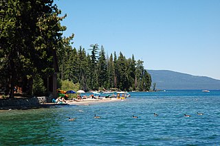
Ed Z'berg Sugar Pine Point State Park is a state park in California in the United States. It occupies nearly two miles of the western shore of Lake Tahoe and a total of about 1,000 hectares of forested mountains in El Dorado County. Originally called Sugar Pine Point State Park, its name was changed in 2003 to honor Edwin L. Z'berg, a California state assemblyman who specialized in environmental legislation and worked to develop state parks and other natural areas.