Borrego Springs is a census-designated place (CDP) in northeastern San Diego County, California. The population was 4,031 at the 2020 census, up from 3,429 at the 2010 census, and 2,535 at the 2000 census, including both seasonal and year-round residents. Borrego Springs is surrounded by Anza-Borrego State Park, California's largest state park.

The Sonoran Desert is a hot desert in North America and ecoregion that covers the northwestern Mexican states of Sonora, Baja California, and Baja California Sur, as well as part of the southwestern United States. It is the hottest desert in both Mexico and the United States. It has an area of 260,000 square kilometers (100,000 sq mi).

Anza-Borrego Desert State Park is a California State Park located within the Colorado Desert of southern California, United States. The park takes its name from 18th century Spanish explorer Juan Bautista de Anza and borrego, a Spanish word for sheep. With 585,930 acres (237,120 ha) that includes one-fifth of San Diego County, it is the largest state park in California and the third largest state park nationally.

The Fish Creek Mountains Wilderness is located about 25 miles west of Brawley, California, and southeast of the Vallecito Mountains in the United States. The wilderness is located in the Fish Creek Mountains region in the northern part of the Carrizo Impact Area, which is closed to the public.
The University of California Natural Reserve System (UCNRS) is a system of protected areas throughout California. The reserves support UC's mission of teaching, research, and public service. Unlike national and state parks, they are not available for recreational uses, because they were specifically created to enable UC scientists to conduct research free from such distractions.
The Mojave and Colorado Deserts Biosphere Reserve is a biosphere reserve designated by UNESCO in 1984 to promote the ecological conservation of a cluster of areas in the Mojave and Colorado deserts of California. A principal feature is Death Valley. The four management units encompassed by the reserve upon its creation were:
Alphonse A. Burnand Jr. was an American sailor who competed in the 1932 Summer Olympics.

The Sawtooth Mountains Wilderness is a federal wilderness area of 32,136 acres (130.0 km2) located in the Sawtooth Mountains in eastern San Diego County, California. It is located in the Colorado Desert, 35 miles (56 km) south of Borrego Springs, near Anza Borrego Desert State Park.

The Santa Rosa Wilderness is a 72,259-acre (292.42 km2) wilderness area in Southern California, in the Santa Rosa Mountains of Riverside and San Diego counties, California. It is in the Colorado Desert section of the Sonoran Desert, above the Coachella Valley and Lower Colorado River Valley regions in a Peninsular Range, between La Quinta to the north and Anza Borrego Desert State Park to the south. The United States Congress established the wilderness in 1984 with the passage of the California Wilderness Act, managed by both the US Forest Service and the Bureau of Land Management. In 2009, the Omnibus Public Land Management Act was signed into law which added more than 2,000 acres (8.1 km2). Most of the Santa Rosa Wilderness is within the Santa Rosa and San Jacinto Mountains National Monument.
The Regions of the San Diego metropolitan area and San Diego County, as they cover the same area are:
Shelter Valley is a community in San Diego County in the U.S. state of California. The town is located along County Route S2, two miles (3.2 km) south of its intersection with State Route 78 and 12 miles (19 km) east of Julian. It lies within the boundaries of the Anza-Borrego Desert State Park and the geologic feature known as Earthquake Valley. The Pacific Crest Trail passes along the northern boundary of the community.

Agua Caliente County Park is a 910 acres park with geothermally heated springs. The park is located just west of Anza-Borrego Desert State Park, in eastern San Diego County, California. Agua Caliente is located about 110 miles (180 km) east of downtown San Diego. Spring water feed pools include an outdoor swimming pool, an outdoor wading pool for children, and an indoor 102 °F (39 °C) therapeutic spa. Site amenities include a caravan area, full and partial hookup RV sites, non-hookup sites, tent camping, and cabins. Facilities include shuffle board, horseshoes, day use picnic area, and dressing rooms. 3.95 miles (6.36 km) hiking trails from flat terrain to steep rocky trails.
Diana Lindsay is the founder and president of Sunbelt Publications, an independent publishing house that focuses on natural science, historical and cultural interests, and the San Diego region. She is also an award-winning author and photographer and has been writing about the Anza-Borrego region since the 1960s.

Clinton Gilbert Abbott was an American ornithologist, naturalist, and Director of the San Diego Natural History Museum from 1922 to 1946. Abbott supervised the construction of the museum's current building in Balboa Park, expanded research field trips and expeditions, and participated in important conservation efforts in southern California and the Baja California region. He was instrumental in the preservation of the southern California desert area that became Anza-Borrego Desert State Park.
Borrego Valley Groundwater Basin, located in the very southern region of California, is one of the driest basins in the state. With climate change predicted to have strong effects into foreseeable future, the region is viewed with a skepticism in the sustainable use of water at current rates of consumption. Both natural and man-made geographic divisions within this basin allow for a closer inspection of the various management techniques implemented throughout the years, and provide a basis for what may be pursued for an uncertain future.
Travis E. Huxman is an American plant physiological ecologist.

San Gregorio campsite at the Borrego Sink in the Borrego Valley, Borrego Springs, California in San Diego County, is a California Historical Landmark No. 673 listed on February 16, 1959. The San Gregorio campsite was a desert camp for the Spanish Commander Juan Bautista de Anza's expedition of 1775 and 1776. The expedition passed through the Imperial Valley then through the Colorado Desert, now the Anza-Borrego Desert State Park. The expedition's goal was to start Spanish missions in California and presidio forts through Las Californias to the San Francisco Bay. The expedition route is now the Juan Bautista de Anza National Historic Trail.

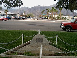
El Vado campsite in the Borrego Valley, Borrego Springs, California in San Diego County, is a California Historical Landmark No. 634 listed on March 3, 1958. The El Vado campsite was a desert camp for the Spanish Commander Juan Bautista de Anza and Father Francisco Garcés expedition of 1775 and 1776. The expedition camped for three days and two nights from December 20 to 22, 1775. At the campsite the expedition rested and watered its stock of mules, cattle, and horses.

Santa Catarina campsite in the Borrego Valley, Borrego Springs, California in San Diego County, is a California Historical Landmark No. 785 listed on March 3, 1958. The Santa Catarina campsite was a desert camp for the Spanish Commander Juan Bautista de Anza and Father Francisco Garcés expedition of 1775 and 1776. At the campsite the expedition rested and watered its stock of mules, cattle, and horses on March 14, 1774.