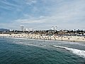
Santa Monica is a city in Los Angeles County, situated along Santa Monica Bay on California's South Coast. Santa Monica's 2020 U.S. Census population was 93,076. Santa Monica is a popular resort town, owing to its climate, beaches, and hospitality industry. It has a diverse economy, hosting headquarters of companies such as Hulu, Activision Blizzard, Universal Music Group, Lionsgate, Illumination and The Recording Academy.

Hermosa Beach is a beachfront city in Los Angeles County in the U.S. state of California, United States. Its population was 19,728 at the 2020 U.S. Census. The city is located in the South Bay region of the Greater Los Angeles area; it is one of the three Beach Cities. Hermosa Beach is bordered by the other two, Manhattan Beach to the north and Redondo Beach to the south and east.

Playa del Rey is a seaside neighborhood on the westside of Los Angeles in the Santa Monica Bay region of Los Angeles County, California. It has a ZIP code of 90293 and area codes of 310 and 424. As of 2018, the community had a population of 16,230 people.

Pacific Palisades is a neighborhood in the Westside region of Los Angeles, California, situated about 20 miles (32 km) west of Downtown Los Angeles.

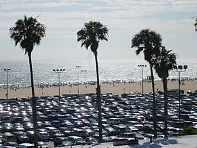
Santa Monica Bay is a bight of the Pacific Ocean in Southern California, United States. Its boundaries are slightly ambiguous, but it is generally considered to be the part of the Pacific within an imaginary line drawn between Point Dume, in Malibu, and the Palos Verdes Peninsula. Its eastern shore forms the western boundary of the Los Angeles Westside and South Bay regions. Although it was fed by the Los Angeles River until the river's catastrophic change of course in 1825, the only stream of any size now flowing into it is Ballona Creek. Smaller waterways draining into the bay include Malibu Creek, Topanga Creek, and Santa Monica Creek.

The Santa Monica Pier is a large pier at the foot of Colorado Avenue in Santa Monica, California, United States. It contains a small amusement park, concession stands, and areas for views and fishing. The pier is part of the greater Santa Monica Mountains National Recreation Area.
The history of Santa Monica, California covers the significant events and movements in Santa Monica's past.

The Santa Monica Mountains National Recreation Area is a United States national recreation area containing many individual parks and open space preserves, located primarily in the Santa Monica Mountains of Southern California. The SMMNRA is in the greater Los Angeles region, with two thirds of the parklands in northwest Los Angeles County, and the remaining third, including a Simi Hills extension, in southeastern Ventura County.

The Marvin Braude Bike Trail is a 22-mile (35 km) paved bicycle path that runs mostly along the shoreline of Santa Monica Bay in Los Angeles County, California. The coastal bike trail is widely acknowledged as Los Angeles' "most popular bike path."

Ocean Avenue is a road in Santa Monica, California.
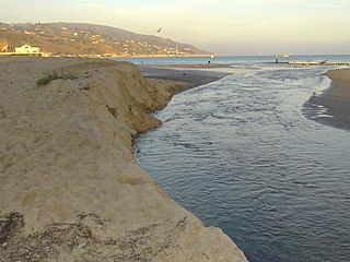
Malibu Lagoon State Beach in Malibu, California, United States, is also known as Surfrider Beach. It was dedicated as the first World Surfing Reserve on October 9, 2010. The 110-acre (45 ha) site was established as a California state park in 1951. It lies within the Santa Monica Mountains National Recreation Area.

The Huntington Beach Pier is a municipal pier located in Huntington Beach, California, at the west end of Main Street and west of Pacific Coast Highway. At 1,850 ft (560 m) in length, it is one of the longest public piers on the West Coast of the United States. The deck of the pier is 30 ft (9.1 m) above sea level, while the top of the restaurant structure at the end of the pier is 77 ft (23 m).

Point Mugu State Park is a state park located in the Santa Monica Mountains National Recreation Area in Southern California. The rugged, nearly impassible shoreline of the western Santa Monica Mountains gives way to tidal lagoons and coastal sand dunes at Mugu Rock. The western edge of the park adjoins Mugu Lagoon which is a protected area within Naval Air Station Point Mugu.
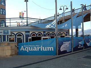
Heal the Bay Aquarium, previously named the Santa Monica Pier Aquarium, is a private-public aquarium at a California State Beach Park managed by Los Angeles County Department of Beaches and Harbors, located beneath the Santa Monica Pier, adjacent to the Pacific Ocean. Since 2003, it is operated by Heal the Bay, a nonprofit organization. It was formerly known as the Ocean Discovery Center and was operated by UCLA until 2003.
Nicolás Rolando Gabaldón was an early surfer who is credited by surfing experts with being California's first documented surfer of African-American and Latino descent at a time when many beaches were segregated and opportunities for minorities more limited than today. Despite being an amateur recreational surfer rather than a professional competitive surfer, he is widely considered a role model for his part in the history of surfing and African American history in the areas of Santa Monica and California.

The Manhattan Beach Pier is a pier located in Manhattan Beach, California on the coast of the Pacific Ocean. The pier is 928 feet (283 m) long and located at the end of Manhattan Beach Boulevard. An octagonal Mediterranean-style building sits at the end of the pier and houses the Roundhouse Aquarium. Surfers usually can be seen below the pier. The pier is popular with locals, tourists, photographers, and artists and for fishing. It offers sunsets and vantage points from the shore and hillside. The pier includes the Volleyball Walk of Fame, featuring plaques dedicated to past winners of the Manhattan Beach Open beach volleyball tournament.
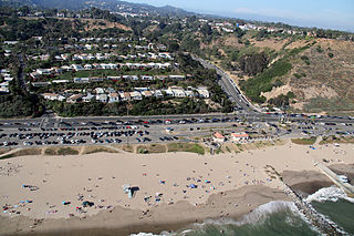
Will Rogers State Beach is a beach park on the Santa Monica Bay, at the Pacific coast of Southern California. Located in the Pacific Palisades neighborhood of Los Angeles, the beach is owned by the California Department of Parks and Recreation; it is managed and maintained by the Los Angeles County Department of Beaches and Harbors.

The Annenberg Community Beach House at Santa Monica State Beach is a public beach facility, open to all. The Beach House is on the location of a now-demolished 110-room mansion that was built for Marion Davies by William Randolph Hearst. The mansion's original pool was rehabilitated by the Annenberg Foundation and opened to the public on a fee-for-entry basis in 2009. The pool is trimmed in tile and has a marble deck. One of the mansion's original guest houses also still exists and is used for events.

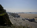
The California Incline is a slanted road in Santa Monica, California, connecting Ocean Avenue with State Route 1. It technically is the last link, the western end of California Avenue, a major east–west street in Santa Monica.
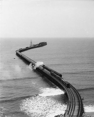
The Long Wharf in Santa Monica, also known as Port Los Angeles or the Mile Long Pier, was an extensive pier wharf constructed by the Southern Pacific Railroad Company in Santa Monica Bay from 1892 to 1894. When it opened in 1894, it was the longest wharf in the world, measuring approximately 4,700 feet (1,400 m). It served as a cargo and passenger port until 1913, and in 1919 removal of the wharf started. The wharf, the 1,000 foot (300 m) tip of the pier, was removed by 1915. The remaining 3,600 feet (1,100 m) of pier was used as a run down fishing pier until 1933, when the remainder of the pier was removed. One of the major imports to the wharf was lumber from Northern ports, to help in the construction boom in Southern California. Southern Pacific Railroad and the street cars of the Los Angeles Pacific Railroad served the wharf. Los Angeles Pacific Railroad ran passenger trams to the wharf and from midnight to sunrise ran cargo cars.