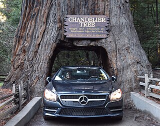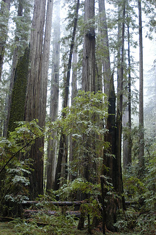
Humboldt Redwoods State Park is a state park of California, United States, containing Rockefeller Forest, the world's largest remaining contiguous old-growth forest of coast redwoods. It is located 30 miles (48 km) south of Eureka, California, near Weott in southern Humboldt County, within Northern California, named after the great nineteenth-century scientist, Alexander von Humboldt. The park was established by the Save the Redwoods League in 1921 largely from lands purchased from the Pacific Lumber Company. Beginning with the dedication of the Raynal Bolling Memorial Grove, it has grown to become the third-largest park in the California State Park system, now containing 51,651 acres (20,902 ha) through acquisitions and gifts to the state.

Benbow State Recreation Area is a state park unit of California in the United States. It is located in Humboldt County 2 miles (3.2 km) south of Garberville on U.S. Route 101 on the South Fork Eel River.

The Eel River is a major river, about 196 miles (315 km) long, of northwestern California. The river and its tributaries form the third largest watershed entirely in California, draining a rugged area of 3,684 square miles (9,540 km2) in five counties. The river flows generally northward through the Coast Ranges west of the Sacramento Valley, emptying into the Pacific Ocean about 10 miles (16 km) downstream from Fortuna and just south of Humboldt Bay. The river provides groundwater recharge, recreation, and industrial, agricultural and municipal water supply.

The Avenue of the Giants is a scenic highway in northern California, United States, running through Humboldt Redwoods State Park. It is named after the coastal redwoods that tower over the route. The road is a former alignment of U.S. Route 101, and continues to be maintained as a state highway as State Route 254.

The Navarro River is a 28.3-mile-long (45.5 km) river in Mendocino County, California, United States. It flows northwest through the Coastal Range to the Pacific Ocean. The main stem of the Navarro River begins less than 1 mile (2 km) south of the town of Philo at the confluence of Rancheria Creek and Anderson Creek. The mouth of the Navarro is 10 miles (16 km) south of the city of Mendocino. State Route 128 starts from the intersection of State Route 1 at the mouth of the Navarro River, and follows the river valley upstream to Philo. The river is close to the highway through the lower canyon but is some distance south of the highway as the Anderson Valley widens upstream of Wendling.

Navarro River Redwoods State Park is a state park in Mendocino County, California, consisting of 660 acres (2.7 km2) of second-growth redwood forest in a narrow stretch 11 miles (18 km) long on both banks of the Navarro River, from the town of Navarro to the river's confluence with the Pacific Ocean.

Hendy Woods State Park is a California state park, located in the Anderson Valley of Mendocino County. It is known for its old-growth coast redwoods and also provides camping facilities near the wineries of the Anderson Valley. It is named after Joshua Hendy, who owned the land and stipulated that it be protected; it passed through several owners after Hendy without being logged, before becoming part of the California State Park system in 1958.

Save the Redwoods League is a nonprofit organization whose mission is to protect and restore coast redwood and giant sequoia trees through the preemptive purchase of development rights of notable areas with such forests.

Montgomery Woods State Natural Reserve is a 1,323-acre state-owned park located in the Coastal Range in Mendocino County, California, United States. The Reserve occupies the headwaters of Montgomery Creek, a tributary of Big River, which flows into the Pacific Ocean at Mendocino Headlands State Park. The virgin groves of Coast Redwood in Montgomery Woods are examples of a now rare upland riparian meadow habitat; most other preserved redwood groves are on broad alluvial plains. The Reserve is accessed from a parking area along Orr Springs Road 13 miles (21 km) west of Ukiah, California, or 15 miles (24 km) east of Comptche, California. A moderately steep trail from the parking area climbs uphill along Montgomery Creek about three-quarters of a mile. Once in the grove, the trail makes a meandering three mile (5 km) loop, with substantial use of boardwalks to protect the fragile forest floor. The reserve was initiated by a 9-acre donation from Robert T. Orr in 1945, with 765 acres donated since 1947 by the Save the Redwoods League.

Richardson Grove State Park is located at the southernmost border of Humboldt County, 75 miles (121 km) south of Eureka, California, United States, and 200 miles (320 km) north of San Francisco. The year-round park, which has approximately 2,000 acres (8.1 km2), straddles US 101, causing the narrowest point of its entire distance. Said to have the 9th largest tree of all remaining Coast Redwoods, it is known for swimming on the South Fork of the Eel River and day use in addition to 159 campsites.

East Fork Russian River is a 15 mi (24 km) long tributary of the Russian River in Mendocino County, California artificially connected to the Eel River via an interbasin diversion at the Potter Valley Project hydroelectric facility. It forms in the north of Potter Valley, flows south through this valley, then southwest through a mountain pass to Lake Mendocino, an artificial reservoir that empties into Russian River. At one time Clear Lake to the east drained through Cold Creek then along the lower part of East Fork Russian River through Coyote Valley to the Russian River proper. A few hundred years ago a massive landslide blocked this channel, and Clear Lake found a new outlet to the Sacramento River.

Leggett is a census-designated place in Mendocino County, California, United States. It is located on the South Fork of the Eel River, 21 miles (34 km) by road northwest of Laytonville, at an elevation of 984 ft (300 m). It is home to some of the largest trees in the world. The nearby Smithe Redwoods State Natural Reserve and Standish-Hickey State Recreation Area are noted for their forests of coastal redwoods. The population of Leggett was 77 at the 2020 census, down from 122 at the 2010 census.

Bull Creek is a locality 11 miles (18 km) south-southeast of Scotia, at an elevation of 7 feet (2.1 m) in Humboldt County, California. Bull Creek Road parallels Bull Creek and is also known as the Mattole Road.

Andersonia is an unincorporated community in Mendocino County, California. It is located near U.S. Route 101 on the South Fork of the Eel River 1 mile (1.6 km) north-northwest of Piercy, at an elevation of 541 feet.
Reynolds Wayside Campground is a state park in Mendocino County, California, United States. The site, which contained a redwood grove, was purchased by Frank W. Reynolds and his wife in 1928 and converted into a resort known as Reynolds Redwood Flat in 1930. After Mr. Reynolds died in 1962, the site was leased until the California state government purchased it in 1966 as a memorial to Reynolds and to protect it from logging. Under state management, 50 campsites were constructed at the site, which was renamed to Reynolds State Recreation Area before taking its present name. In 1976, the campsites were removed and the property was deemed surplus the next year. Much of the site's land was exchanged with a timber company for territory at Sinkyone Wilderness State Park in 1984. As of May 2021, Reynolds Wayside Campground contains 38 acres (15 ha) of land, including area for hiking and access to the Eel River.

The South Fork Eel River is the largest tributary of the Eel River in north-central California in the United States. The river flows 105 miles (169 km) north from Laytonville to Dyerville/Founders' Grove where it joins the Eel River. The South Fork drains a long and narrow portion of the Coast Range of California in parts of Mendocino and Humboldt counties. U.S. Route 101 follows the river for much of its length.

Bull Creek is the largest Eel River tributary drainage basin preserved within Humboldt Redwoods State Park. The basin contains the world's largest remaining contiguous old-growth forest of coast redwoods. Bull Creek flows in a clockwise semi-circle around 3,373-foot (1,028-meter) Grasshopper Mountain to enter the South Fork Eel River approximately 1.5 miles (2.4 km) upstream of the South Fork confluence with the Eel River.

There are nine national parks located in the state of California managed by the National Park Service. National parks protect significant scenic areas and nature reserves, provide educational programs, community service opportunities, and are an important part of conservation efforts in the United States. There are several other locations inside of California managed by the National Park Service, but carry other designations such as National Monuments. Many of the national parks in California are also part of national forests and National Wildlife Refuges, and contain Native American Heritage Sites and National Monuments.
Sequoia County was a proposal in the early 1990s, to create a new California out of parts of Southern Humboldt and Northern Mendocino counties. The 1992 proposal halted signature gathering due to low support. The proponents of the proposal, restarted in 1993, submitted signatures in January 1994 to the Humboldt County clerk, who validated 2,033 signatures, 169 short of the necessary number to qualify for possible inclusion on the 1996 ballot.
The Great Redwood Trail is a proposed multi-use rail-to-trail project connecting San Francisco and Humboldt bays in Northern California. Most of the trail will be built on the rail bed of the defunct Northwestern Pacific Railroad along the Eel River Canyon by the Great Redwood Trail Agency. The southern portion will be built by Sonoma–Marin Area Rail Transit (SMART) along their commuter rail line. The trail route is within 5 counties, 14 cities and the ancestral territory of many tribes. Some portions have already constructed by local jurisdictions with more being developed in cooperation with local governments.


