Mission San Buenaventura, formally known as the Mission Basilica of San Buenaventura, is a Catholic parish and basilica in the Archdiocese of Los Angeles. The parish church in the city of Ventura, California, United States, is a Spanish mission founded by the Order of Friars Minor. Founded on March 31, 1782, it was the ninth Spanish mission established in Alta California and the last to be established by the head of the Franciscan missions in California, Junípero Serra. Designated a California Historical Landmark, the mission is one of many locally designated landmarks in downtown Ventura.

Ventura County is a county located in the southern part of the U.S. state of California. As of the 2020 census, the population was 843,843. The largest city is Oxnard, and the county seat is the city of Ventura.

Ventura, officially named San Buenaventura, is a city in and the county seat of Ventura County, California, United States. It is a coastal city located northwest of Los Angeles. The population was 110,763 at the 2020 census. Ventura is a popular tourist destination, owing to its historic landmarks, beaches, and resorts.

The Oregon Coast Trail (OCT) is a long-distance hiking route along the Pacific coast of the U.S. state of Oregon in the United States. It follows the coast of Oregon from the mouth of the Columbia River to the California border south of Brookings.

Half Moon Bay State Beach is a 4-mile (6 km) stretch of protected beaches in the state park system of California, United States, on Half Moon Bay. From north to south it comprises Roosevelt, Dunes, Venice, and Francis Beaches. The 181-acre (73 ha) park was established in 1956.

Emma Wood State Beach is a California State Beach in Ventura, California. It is located on the Santa Barbara Channel on the west side of the Ventura River estuary and south of the railroad tracks of the Coast Line and the US Highway 101 freeway.

Mandalay State Beach is a protected beach in the city of Oxnard, California, United States. Managed by the California Department of Parks and Recreation, the park preserves an area of undeveloped sand dunes and wetlands that was once common along the 16.5-mile-long (26.6 km) coastline of the Oxnard Plain.
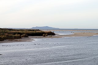
McGrath State Beach is a protected beach park located on the south bank of the mouth of Santa Clara River in the city of Oxnard, California. McGrath State Beach is one of the best bird-watching areas in California, with the lush riverbanks of the Santa Clara River and sand dunes along the shore. A nature trail leads to the Santa Clara Estuary Natural Preserve. Camping sites are available. Two miles of beach provide surfing and fishing opportunities. Just south of the station is the undeveloped Mandalay Beach Park which is about a mile downcoast beach walk from the park or a bike ride along Harbor Blvd. Located south of Ventura on Harbor Boulevard, the beach is on the Pacific Coast Bicycle Route and the California Coastal Trail.

Guadalupe-Nipomo Dunes is the largest remaining dune system south of San Francisco and the second largest in the U.S. state of California. It encompasses an 18-mile (29 km) stretch of coastline on the Central Coast of California and extends from southern San Luis Obispo County to northern Santa Barbara County.
Pacifica State Beach is the southernmost of Pacifica, California's large beaches. It is a 0.75-mile-long (1.21 km) crescent-shaped beach located at the mouth of the San Pedro Valley in downtown Pacifica off State Route 1, in San Mateo County. Over one million people visit this beach annually.

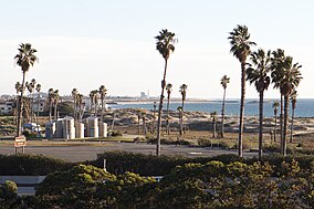
Ventura station is a passenger rail station in downtown Ventura, California. The station is served by Amtrak's Pacific Surfliner from San Luis Obispo to San Diego. Ten Pacific Surfliner trains serve the station daily. Of the 73 California stations served by Amtrak, Ventura was the 33rd-busiest in FY2010, boarding or detraining an average of approximately 125 passengers daily. The single platform is located on the south side of the tracks with a view of the Santa Barbara Channel and the Channel Islands. The Ventura Freeway is parallel with and on the north side of tracks.

Estero Bluffs State Park is a state park of California, United States, on Estero Bay. The park protects a grassland-dominated marine terrace that slopes from California State Route 1 to the Pacific Ocean. The property is crossed by San Geronimo and Villa Creeks and is just north of the town of Cayucos. The 353-acre (143 ha) park was established in 2000.

Santa Monica State Beach is a California State Park operated by the city of Santa Monica.

The San Buenaventura Mission Aqueduct was a seven-mile long, stone and mortar aqueduct built in the late 18th and/or early 19th century to transport water from the Ventura River to the Mission San Buenaventura in Ventura, California.
The Rincon Parkway is a portion of California State Route 1 along the north coast of Ventura County, California. This narrow coastal area north of the city of Ventura and south of the Santa Barbara County line is commonly referred to as The Rincon. The automobile route along this portion of coastline opened up in 1913 as the Rincon Causeway or the Rincon Sea Level Road as the first driveable coastal route for motorists traveling between San Francisco and Los Angeles, California. The access road alongside the railroad bed, that cut through the area in 1886, provided the basis for building the Rincon Sea Level Road.

Moss Landing Wildlife Area is a California State wildlife preserve on the shore of Elkhorn Slough.
Seaside Park is an event venue in Ventura, California, United States. The 62-acre site (25 ha) is the home of the Ventura County Fair. Trade shows, concerts, and other events are held throughout the year at the fairgrounds. The beachfront site, near the mouth of the Ventura River, also includes Surfers' Point, known for its point break that produces distinctive waves.

Omer Leonard Rains is an American politician, lawyer, author, ecologist, and humanitarian. He served in the California State Senate from 1974 to 1986.

The Serra Cross, sometimes also known as the Cross on the Hill or the Grant Park Cross, is a Christian cross on a hill known as "La Loma de la Cruz" in Ventura, California. The site is in Serra Cross Park, a one-acre parcel within the larger Grant Park that overlooks downtown Ventura, the Santa Barbara Channel, and Anacapa and Santa Cruz Islands.

Ragged Point is a headland on California's Central Coast. It is located at the southern end of Big Sur in northern San Luis Obispo County. The Ragged Point Inn and Resort is located in the area, which, as with much of Big Sur, features seaside cliffs, beaches, and hiking trails.