
Interactive map of LaTour Demonstration State Forest
LaTour Demonstration State Forest is a state forest totaling 9,033 acres in the southern Cascade Range and Shasta County, in northern California. [1]
Contents
It became a state forest in 1946.
LaTour Demonstration State Forest is a state forest totaling 9,033 acres in the southern Cascade Range and Shasta County, in northern California. [1]
It became a state forest in 1946.
It is located at the edge of the Lassen National Forest. south of Burney and east of Redding. [1]
LaTour forest contains many interesting volcanic and glacial geological features.
The forest is accessible by vehicle from late June to November. [2]
The forest supports 10 coniferous tree species of commercial value. These are sugar pine, ponderosa pine, Jeffrey pine, western white pine, lodgepole pine, Douglas fir, white fir, red fir, incense cedar, and mountain hemlock. [1]
The stands contain lesser amounts of hardwood trees, such as California black oak, canyon live oak, big leaf maple, and red alder. [1]
The Douglas fir is an evergreen conifer species in the pine family, Pinaceae. It is native to western North America and is also known as Douglas-fir, Douglas spruce, Oregon pine, and Columbian pine. There are three varieties: coast Douglas-fir, Rocky Mountain Douglas-fir and Mexican Douglas-fir.

The western tanager, is a medium-sized American songbird. Formerly placed in the tanager family (Thraupidae), other members of its genus and it are classified in the cardinal family (Cardinalidae). The species's plumage and vocalizations are similar to other members of the cardinal family.

The Klamath Mountains are a rugged and lightly-populated mountain range in northwestern California and southwestern Oregon in the western United States. As a mountain system within both the greater Pacific Coast Ranges and the California Coast Ranges, the Klamath Mountains have a varied geology, with substantial areas of serpentinite and marble, and a climate characterized by moderately cold winters with very heavy snowfall and warm, very dry summers with limited rainfall, especially in the south. As a consequence of the geology and soil types, the mountains harbor several endemic or near-endemic trees, forming one of the largest collections of conifers in the world. The mountains are also home to a diverse array of fish and animal species, including black bears, large cats, owls, eagles, and several species of Pacific salmon. Millions of acres in the mountains are managed by the United States Forest Service. The northernmost and largest sub-range of the Klamath Mountains are the Siskiyou Mountains.

Sierra de San Pedro Mártir is a mountain range located within southern Ensenada Municipality and southern Baja California state, of northwestern Mexico.

The ecology of the Sierra Nevada, located in the U.S. states of California and Nevada, is diverse and complex. The combination of climate, topography, moisture, and soils influences the distribution of ecological communities across an elevation gradient from 500 to 14,500 feet. Biotic zones range from scrub and chaparral communities at lower elevations, to subalpine forests and alpine meadows at the higher elevations. Particular ecoregions that follow elevation contours are often described as a series of belts that follow the length of the Sierra Nevada. There are many hiking trails, paved and unpaved roads, and vast public lands in the Sierra Nevada for exploring the many different biomes and ecosystems.

The Northern California coastal forests are a temperate coniferous forests ecoregion of coastal Northern California and southwestern Oregon.

The Shasta–Trinity National Forest is a federally designated forest in northern California, United States. It is the largest National Forest in California and is managed by the U.S. Forest Service. The 2,210,485 acre forest encompasses five wilderness areas, hundreds of mountain lakes and 6,278 miles (10,103 km) of streams and rivers. Major features include Shasta Lake, the largest man-made lake in California and Mount Shasta, elevation 14,179 feet (4,322 m).

Eldorado National Forest is a U.S. National Forest located in the central Sierra Nevada mountain range, in eastern California.

Klehm Arboretum & Botanic Garden is a nonprofit arboretum and botanical garden located at 2715 South Main Street, Rockford, Illinois.

The Appalachian mixed mesophytic forests is an ecoregion of the temperate broadleaf and mixed forests biome, as defined by the World Wildlife Fund. It consists of mesophytic plants west of the Appalachian Mountains in the Southeastern United States.

The Appalachian–Blue Ridge forests are an ecoregion in the Temperate broadleaf and mixed forests Biome, in the Eastern United States. The ecoregion is located in the central and southern Appalachian Mountains, including the Ridge-and-Valley Appalachians and the Blue Ridge Mountains. It covers an area of about 61,500 square miles (159,000 km2) in: northeast Alabama and Georgia, northwest South Carolina, eastern Tennessee, western North Carolina, Virginia, Maryland, and central West Virginia and Pennsylvania; and small extensions into Kentucky, New Jersey, and New York.

California oak woodland is a plant community found throughout the California chaparral and woodlands ecoregion of California in the United States and northwestern Baja California in Mexico. Oak woodland is widespread at lower elevations in coastal California; in interior valleys of the Coast Ranges, Transverse Ranges and Peninsular Ranges; and in a ring around the California Central Valley grasslands. The dominant trees are oaks, interspersed with other broadleaf and coniferous trees, with an understory of grasses, herbs, geophytes, and California native plants.

Stepin Lug or Gaj is a park-forest and, for the most part, non-residential suburban settlement of Belgrade, the capital of Serbia. It is located in Belgrade's municipalities of Voždovac and Zvezdara. It is part of the forest complex Stepin Lug-Baba Velka-Torlak-Jajinci, which is the largest wooden area in Belgrade.

Jackson Demonstration State Forest is a public forest in Mendocino County, California managed by the California Department of Forestry and Fire Protection. It is the largest demonstration forest operated by the State of California. The forest land is located along California State Highway 20 between Willits and the coastal city of Fort Bragg. It is named after Jacob Green Jackson, founder of Caspar Lumber Company, which formerly owned the land. The forest holds sacred value as an ancestral home and ceremonial site for the Coyote Valley Band of Pomo Indians.
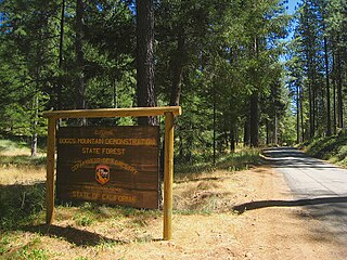
Boggs Mountain Demonstration State Forest is a state forest in Lake County, California that covers the northwest of Boggs Mountain. It was founded in 1949, and came into operation in 1950 when most of the site had been clear cut. The purpose was to demonstrate good practices in restoring and managing a forest. The state forest was open for recreational use, including camping, hiking, mountain biking etc. The 2015 Valley Fire destroyed 80% of the trees. The state forest as of 2021 was replanting saplings.

The Klamath Mountains ecoregion of Oregon and California lies inland and north of the Coast Range ecoregion, extending from the Umpqua River in the north to the Sacramento Valley in the south. It encompasses the highly dissected ridges, foothills, and valleys of the Klamath and Siskiyou Mountains. It corresponds to the Level III ecoregion designated by the Environmental Protection Agency and to the Klamath-Siskiyou forests ecoregion designated by the World Wide Fund for Nature.
Sue-meg State Park is a 640-acre California State Park (260 ha) in Humboldt County, California near Trinidad on the Redwood Coast, situated on a lushly forested promontory above the Pacific Ocean.

The California montane chaparral and woodlands is an ecoregion defined by the World Wildlife Fund, spanning 7,900 square miles (20,000 km2) of mountains in the Transverse Ranges, Peninsular Ranges, and Coast Ranges of southern and central California. The ecoregion is part of the larger California chaparral and woodlands ecoregion, and belongs to the Mediterranean forests, woodlands, and scrub biome.
Mixed coniferous forest is a vegetation type dominated by a mixture of broadleaf trees and conifers. It is generally located in mountains, below the upper montane vegetation type.