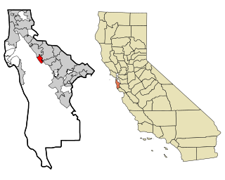
Burney, California

Last updated

Burney
Shasta County California Incorporated and Unincorporated areas Burney Highlighted.svg
Location in Shasta County and the state of California
Coordinates: 40°52′50″N121°40′0″W / 40.88056°N 121.66667°W / 40.88056; -121.66667
Country Flag of the United States (23px).png  United States
State Flag of California.svg  California
County Shasta
Area
[1]
  Total5.38 sq mi (13.93 km2)
  Land5.37 sq mi (13.92 km2)
  Water0.01 sq mi (0.01 km2)  0.09%
Elevation
3,195 ft (952 m)
Population
 (2020)
  Total3,000
  Density558.35/sq mi (215.58/km2)
Time zone UTC-8 (Pacific (PST))
  Summer (DST) UTC-7 (PDT)
ZIP code
96013
Area code 530
FIPS code 06-09122
GNIS feature ID0277481
Website City of Burney Website

Burney is an unincorporated town and census-designated place (CDP) in Shasta County, California, United States. Its population is 3,000 as of the 2020 census, down from 3,154 from the 2010 census. Burney is located on State Route 299, about 4 miles west of its junction with State Route 89.

Contents

Burney Falls Burney Falls 504x402.JPG
Burney Falls

Burney has several areas for fly fishing, with wild brown and native rainbow trout in many nearby rivers and streams, including Burney Creek. Other attractions in the area include McArthur–Burney Falls Memorial State Park, home to Burney Falls.

Burney was named after Samuel Burney, a settler in the area in the 1850s. Burney was found dead in the valley in 1857, which came to be called "the valley where Burney died," and finally just "Burney".

The town of Burney sits at the base of an extinct volcano called Burney Mountain. The peak is 7,863 ft tall (2,397 m).

History

2009 shootout

2009 Burney shootout
LocationBurney, California, United States
DateDecember 15, 2009
12:14 p.m. (UTC-7)
TargetA branch of US Bank
Attack type
hostage taking, shootout
Weapons
Deaths1 (the perpetrator)
Injured2
PerpetratorGregorio Enrique Estrada

[2]

Demographics

Historical population
CensusPop.Note
2020 3,000
U.S. Decennial Census [3]
1850–1870 [4] [5] 1880-1890 [6]
1900 [7] 1910 [8] 1920 [9]
1930 [10] 1940 [11] 1950 [12]
1960 [13] 1970 [14] 1980 [15]
1990 [16] 2000 [17] 2010 [18]

2010

At the 2010 census Burney had a population of 3,154. The population density was 606.5 inhabitants per square mile (234.2/km2). The racial makeup of Burney was 2,685 (85.1%) White, 13 (0.4%) African American, 233 (7.4%) Native American, 7 (0.2%) Asian, 2 (0.1%) Pacific Islander, 61 (1.9%) from other races, and 153 (4.9%) from two or more races. Hispanic or Latino of any race were 265 people (8.4%). [19]

The census reported that 3,035 people (96.2% of the population) lived in households, 119 (3.8%) lived in non-institutionalized group quarters, and no one was institutionalized.

There were 1,262 households, 371 (29.4%) had children under the age of 18 living in them, 638 (50.6%) were opposite-sex married couples living together, 155 (12.3%) had a female householder with no husband present, 70 (5.5%) had a male householder with no wife present. There were 74 (5.9%) unmarried opposite-sex partnerships, and 5 (0.4%) same-sex married couples or partnerships. 344 households (27.3%) were one person and 150 (11.9%) had someone living alone who was 65 or older. The average household size was 2.40. There were 863 families (68.4% of households); the average family size was 2.87.

The age distribution was 751 people (23.8%) under the age of 18, 240 people (7.6%) aged 18 to 24, 681 people (21.6%) aged 25 to 44, 949 people (30.1%) aged 45 to 64, and 533 people (16.9%) who were 65 or older. The median age was 42.5 years. For every 100 females, there were 95.8 males. For every 100 females age 18 and over, there were 91.2 males.

There were 1,446 housing units at an average density of 278.0 per square mile, of the occupied units 797 (63.2%) were owner-occupied and 465 (36.8%) were rented. The homeowner vacancy rate was 2.2%; the rental vacancy rate was 7.4%. 1,833 people (58.1% of the population) lived in owner-occupied housing units and 1,202 people (38.1%) lived in rental housing units.

2000

At the 2000 census there were 3,217 people, 1,311 households, and 912 families in the CDP. The population density was 622.4 inhabitants per square mile (240.3/km2). There were 1,420 housing units at an average density of 274.7 per square mile (106.1/km2). The racial makeup of the CDP was 87.97% White, 0.09% African American, 6.87% Native American, 0.65% Asian, 0.06% Pacific Islander, 2.14% from other races, and 2.21% from two or more races. Hispanic or Latino of any race were 5.97%. [20]

Of the 1,311 households 33.5% had children under the age of 18 living with them, 54.4% were married couples living together, 11.7% had a female householder with no husband present, and 30.4% were non-families. 26.2% of households were one person and 13.7% were one person aged 65 or older. The average household size was 2.45 and the average family size was 2.96.

The age distribution was 27.7% under the age of 18, 6.2% from 18 to 24, 23.9% from 25 to 44, 27.1% from 45 to 64, and 15.0% 65 or older. The median age was 40 years. For every 100 females, there were 93.8 males. For every 100 females age 18 and over, there were 89.2 males.

The median household income was $30,510 and the median family income was $37,682. Males had a median income of $42,314 versus $25,139 for females. The per capita income for the CDP was $17,060. About 14.8% of families and 18.0% of the population were below the poverty line, including 18.0% of those under age 18 and 11.1% of those age 65 or over.

Politics

In the state legislature Burney is located in the 1st Senate District , represented by Republican Brian Dahle, [21] and the 1st Assembly District , represented by Republican Megan Dahle. [22]

Federally, Burney is in California's 1st congressional district , represented by Republican Doug LaMalfa. [23]

Parts of the 1986 film Stand by Me were filmed within the vicinity of Burney and Fall River Mills, California. The scene in which the boys outrace a locomotive across a trestle was filmed at Lake Britton on the McCloud River Railroad, near McArthur–Burney Falls Memorial State Park, California. [24]

Jonathan Schmierer, Burney High School graduate, appeared on The Price Is Right during one of Bob Barker's final showings. He lost a game of Tic-Tac-Toe for a trip to the Ramada Inn in Ireland. [25] [26]

Climate

This region experiences warm (but not hot) and dry summers, with no average monthly temperatures above 71.6 °F. According to the Köppen Climate Classification system, Burney has a warm-summer Mediterranean climate, abbreviated "Csb" on climate maps. [27]

Climate data for Burney (1948–2012)
MonthJanFebMarAprMayJunJulAugSepOctNovDecYear
Record high °F (°C)68
(20)
74
(23)
80
(27)
89
(32)
96
(36)
103
(39)
108
(42)
108
(42)
105
(41)
94
(34)
82
(28)
65
(18)
108
(42)
Mean daily maximum °F (°C)43.6
(6.4)
49.4
(9.7)
54.3
(12.4)
61.5
(16.4)
70.5
(21.4)
79.1
(26.2)
88
(31)
86.7
(30.4)
81
(27)
69
(21)
53.1
(11.7)
44.2
(6.8)
65.0
(18.4)
Mean daily minimum °F (°C)20.1
(−6.6)
22.9
(−5.1)
25.8
(−3.4)
29.4
(−1.4)
35.4
(1.9)
41.2
(5.1)
44.4
(6.9)
41.6
(5.3)
35.9
(2.2)
29
(−2)
24.8
(−4.0)
20.4
(−6.4)
30.9
(−0.6)
Record low °F (°C)−20
(−29)
−18
(−28)
1
(−17)
12
(−11)
17
(−8)
21
(−6)
25
(−4)
24
(−4)
17
(−8)
10
(−12)
−3
(−19)
−26
(−32)
−26
(−32)
Average precipitation inches (mm)4.63
(118)
4.09
(104)
3.55
(90)
2.03
(52)
1.49
(38)
0.79
(20)
0.16
(4.1)
0.33
(8.4)
0.7
(18)
1.78
(45)
3.46
(88)
4.84
(123)
27.86
(708)
Average snowfall inches (cm)12
(30)
6.2
(16)
5.8
(15)
2.9
(7.4)
0.3
(0.76)
0
(0)
0
(0)
0
(0)
0
(0)
0.1
(0.25)
3.1
(7.9)
10.6
(27)
41
(100)
Average precipitation days1211129741236101289
Source: WRCC [28]

Related Research Articles

<span class="mw-page-title-main">Alpine Village, California</span> Census-designated place in California, United States

Alpine Village is a census-designated place (CDP) in Alpine County, California, United States. The population was 114 at the 2010 census, down from 136 at the 2000 census.

<span class="mw-page-title-main">Biola, California</span> Census-designated place in California, United States

Biola is a census-designated place (CDP) in Fresno County, California, United States. The population was 1,623 at the 2010 census, up from 1,037 in 2000. Biola is located 6 miles (9.7 km) north-northeast of Kerman, at an elevation of 253 feet.

<span class="mw-page-title-main">Bowles, California</span> Census-designated place in California, United States

Bowles is a census-designated place (CDP) in Fresno County, California, United States. The population was 166 at the 2010 census, down from 182 at the 2000 census. Bowles is located 11 miles (18 km) south of downtown Fresno, at an elevation of 279 feet.

<span class="mw-page-title-main">Cantua Creek, California</span> Census-designated place in California, United States

Cantua Creek is a census-designated place (CDP) in Fresno County, California, United States. As of the 2010 census, the population was 466, down from the 655 reported at the 2000 census. Cantua Creek is located 11 miles (18 km) south-southwest of Tranquillity, at an elevation of 295 feet.

<span class="mw-page-title-main">Bayview, Humboldt County, California</span> Census-designated place in California, United States

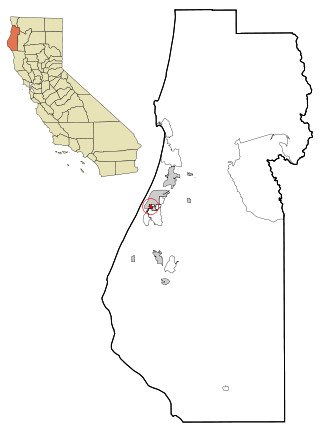
Bayview is a census-designated place (CDP) located adjacent to the City of Eureka in Humboldt County, California, United States. Its population is 2,619 as of the 2020 census, up from 2,510 from the 2010 census. Many locals consider this area as part of "Pine Hill."

<span class="mw-page-title-main">Cartago, California</span> Census-designated place in California, United States

Cartago is a census-designated place in Inyo County, California, United States. Cartago is located on the west side of Owens Lake 3 miles (4.8 km) north-northwest of Olancha. The population was 92 at the 2010 census, down from 109 at the 2000 census.

<span class="mw-page-title-main">Bodfish, California</span> Census-designated place in California, United States

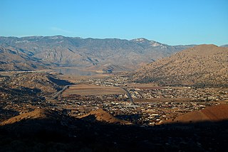
Bodfish is a census-designated place (CDP) in the southern Kern River Valley of the Southern Sierra Nevada, in Kern County, California.

<span class="mw-page-title-main">Citrus, California</span> Census-designated place in California, United States

Citrus is a census-designated place (CDP) in Los Angeles County, California, United States. It is located in the San Gabriel Valley between Azusa to the north and west, Glendora to the east, and Covina to the south. The population was 10,866 at the 2010 census, up from 10,581 at the 2000 census. Citrus is named after Citrus Avenue, which passes through the community.

<span class="mw-page-title-main">Bradley, California</span> Unincorporated community in California, United States

Bradley is an unincorporated community and census-designated place (CDP) in Monterey County, California, on the Salinas River 14 miles (23 km) south-southeast of San Ardo and 20 miles (32 km) north of Paso Robles. Bradley sits at an elevation of 548 feet (167 m). The population was 69 at the 2020 census, down from 93 at the 2010 census.

<span class="mw-page-title-main">Blairsden, California</span> Census-designated place in California, United States

Blairsden is a census-designated place (CDP) in Plumas County, California, United States. Blairsden is located 20 miles (32.2 km) east-southeast of Quincy. It is located on the Feather River Route. The population was 39 at the 2010 census, down from 50 at the 2000 census.

<span class="mw-page-title-main">C-Road, California</span> Census-designated place in California, United States

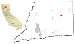
C-Road is a census-designated place (CDP) in Plumas County, California, United States. The population was 150 at the 2010 census, down from 152 at the 2000 census.

<span class="mw-page-title-main">Big River, California</span> Census-designated place in California, United States

Big River is a census-designated place (CDP) in San Bernardino County, California, United States. The population was 1,084 at the 2020 census, down from 1,327 at the 2010 census.

<span class="mw-page-title-main">Bluewater, California</span> Census-designated place in California, United States

Bluewater is a census-designated place (CDP) in San Bernardino County, California, United States. The population was 172 at the 2010 census, down from 265 at the 2000 census.

<span class="mw-page-title-main">Camp Pendleton South, California</span> Census-designated place in California, United States

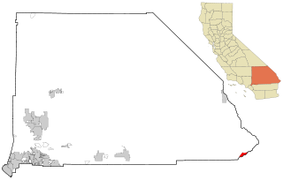
Camp Pendleton South is a census-designated place (CDP) in San Diego County, California, located at the southwest corner of the Marine Corps Base Camp Pendleton. The population was 10,616 at the 2010 census, up from 8,854 at the 2000 census. Much of the population are residents of Camp Pendleton barracks situated in the area, as well as housing communities for married Marine and Navy personnel and their families. It, along with Camp Pendleton Mainside CDP, is one of two CDPs on the base.

<span class="mw-page-title-main">Country Club, California</span> Census-designated place in California, United States

Country Club is a census-designated place (CDP) in San Joaquin County, California, United States. The population was 9,379 at the 2010 census, down from 9,462 at the 2000 census. It comprises an unincorporated "island" within the City of Stockton.

<span class="mw-page-title-main">Highlands-Baywood Park, California</span> Unincorporated community in California, United States

Highlands-Baywood Park is an unincorporated community and former census designated place (CDP) in in San Mateo County, California, United States. The population was 4,027 at the 2010 census.

<span class="mw-page-title-main">Cottonwood, California</span> Census-designated place in the United States

Cottonwood is a census-designated place (CDP) in Shasta County, California, United States. Its population is 6,268 as of the 2020 census, up from 3,316 from the 2010 census. Cottonwood was a stagecoach town where a settlement was established in 1849. The first Post Office was opened in 1852. Cottonwood is equidistant between Redding and Red Bluff, 15 miles (24 km) in either direction. It is 4 miles (6.4 km) south of Anderson.
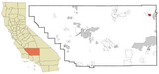
Bret Harte is a census-designated place (CDP) in Stanislaus County, California, United States. The population was 5,152 at the 2010 census, down from 5,161 at the 2000 census. It is part of the Modesto Metropolitan Statistical Area. It is named for the American poet and short story writer, Bret Harte, best known for his writings about the California Gold Rush.

<span class="mw-page-title-main">Bystrom, California</span> Census-designated place in California, United States

Bystrom is a census-designated place (CDP) in Stanislaus County, California, United States. The population was 4,008 at the 2010 census, down from 4,518 at the 2000 census. It is part of the Modesto Metropolitan Statistical Area.

<span class="mw-page-title-main">China Lake Acres, California</span> Census-designated place in California, United States

China Lake Acres is a census-designated place (CDP) in Kern County, California, United States. The population was 1,876 at the 2010 census, up from 1,761 at the 2000 census.

References

  1. "2020 U.S. Gazetteer Files". United States Census Bureau. Retrieved October 30, 2021.
  2. "Money Not Motive in Burney US Bank Standoff !Update! Shooter Identified". December 17, 2009.
  3. "Decennial Census by Decade". United States Census Bureau .
  4. "1870 Census of Population - Population of Civil Divisions less than Counties - California - Almeda County to Sutter County" (PDF). United States Census Bureau .
  5. "1870 Census of Population - Population of Civil Divisions less than Counties - California - Tehama County to Yuba County" (PDF). United States Census Bureau .
  6. "1890 Census of Population - Population of California by Minor Civil Divisions" (PDF). United States Census Bureau .
  7. "1900 Census of Population - Population of California by Counties and Minor Civil Divisions" (PDF). United States Census Bureau .
  8. "1910 Census of Population - Supplement for California" (PDF). United States Census Bureau .
  9. "1920 Census of Population - Number of Inhabitants - California" (PDF). United States Census Bureau .
  10. "1930 Census of Population - Number and Distribution of Inhabitants - California" (PDF). United States Census Bureau .
  11. "1940 Census of Population - Number of Inhabitants - California" (PDF). United States Census Bureau .
  12. "1950 Census of Population - Number of Inhabitants - California" (PDF). United States Census Bureau .
  13. "1960 Census of Population - General population Characteristics - California" (PDF). United States Census Bureau .
  14. "1970 Census of Population - Number of Inhabitants - California" (PDF). United States Census Bureau .
  15. "1980 Census of Population - Number of Inhabitants - California" (PDF). United States Census Bureau .
  16. "1990 Census of Population - Population and Housing Unit Counts - California" (PDF). United States Census Bureau .
  17. "2000 Census of Population - Population and Housing Unit Counts - California" (PDF). United States Census Bureau .
  18. "2010 Census of Population - Population and Housing Unit Counts - California" (PDF). United States Census Bureau .
  19. "2010 Census Interactive Population Search: CA - Burney CDP". U.S. Census Bureau. Archived from the original on July 15, 2014. Retrieved July 12, 2014.
  20. "U.S. Census website". United States Census Bureau . Retrieved January 31, 2008.
  21. "Senators". State of California. Retrieved March 10, 2013.
  22. "Members Assembly". State of California. Retrieved March 2, 2013.
  23. "California's 1st Congressional District - Representatives & District Map". Civic Impulse, LLC. Retrieved March 1, 2013.
  24. "Along the Line Bartle-Burney". McCloud Rails. McCloud Rails. Retrieved March 15, 2014.
  25. "Jonathan on TV". Intermountain News. Intermountain News. Retrieved May 12, 2015.
  26. "Burney grad on stage for today's airing of TV's Price Is Right" (PDF). The InterMountain News. Burney, California. April 25, 2007. Archived from the original (PDF) on March 4, 2016. Retrieved September 6, 2021.
  27. Climate Summary for Burney, California
  28. "BURNEY, CA (041214)". Western Regional Climate Center. Retrieved November 29, 2015.