Millville | |
---|---|
Coordinates: 40°33′21″N122°11′7″W / 40.55583°N 122.18528°W Coordinates: 40°33′21″N122°11′7″W / 40.55583°N 122.18528°W | |
Country | United States |
State | California |
County | Shasta |
Area | |
• Total | 8.213 sq mi (21.272 km2) |
• Land | 8.046 sq mi (20.839 km2) |
• Water | 0.167 sq mi (0.433 km2) 2.04% |
Elevation | 510 ft (157 m) |
Population (2020) | |
• Total | 724 |
• Density | 88/sq mi (34/km2) |
Time zone | UTC-8 (Pacific (PST)) |
• Summer (DST) | UTC-7 (PDT) |
ZIP code | 96062 |
Area code(s) | 530 |
FIPS code | 06-47724 |
GNIS feature ID | 0228775 |
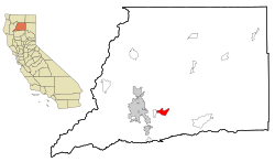
Millville is a census-designated place (CDP) in Shasta County, California, United States. Its population is 724 as of the 2020 census, down from 727 from the 2010 census.
Millville is located at 40°33′21″N122°11′7″W / 40.55583°N 122.18528°W (40.555904, -122.185250). [2]
According to the United States Census Bureau, the CDP has a total area of 8.2 square miles (21 km2), 97.96% of it land and 2.04% of it water.
The 2010 United States Census [3] reported that Millville had a population of 727. The population density was 88.5 inhabitants per square mile (34.2/km2). The racial makeup of Millville was 673 (92.6%) White, 0 (0.0%) African American, 6 (0.8%) Native American, 6 (0.8%) Asian, 1 (0.1%) Pacific Islander, 22 (3.0%) from other races, and 19 (2.6%) from two or more races. Hispanic or Latino of any race were 50 persons (6.9%).
The Census reported that 727 people (100% of the population) lived in households, 0 (0%) lived in non-institutionalized group quarters, and 0 (0%) were institutionalized.
There were 268 households, out of which 95 (35.4%) had children under the age of 18 living in them, 180 (67.2%) were opposite-sex married couples living together, 24 (9.0%) had a female householder with no husband present, 11 (4.1%) had a male householder with no wife present. There were 8 (3.0%) unmarried opposite-sex partnerships, and 3 (1.1%) same-sex married couples or partnerships. 44 households (16.4%) were made up of individuals, and 24 (9.0%) had someone living alone who was 65 years of age or older. The average household size was 2.71. There were 215 families (80.2% of all households); the average family size was 3.05.
The population was spread out, with 178 people (24.5%) under the age of 18, 42 people (5.8%) aged 18 to 24, 126 people (17.3%) aged 25 to 44, 246 people (33.8%) aged 45 to 64, and 135 people (18.6%) who were 65 years of age or older. The median age was 47.4 years. For every 100 females, there were 93.9 males. For every 100 females age 18 and over, there were 94.0 males.
There were 287 housing units at an average density of 34.9 per square mile (13.5/km2), of which 230 (85.8%) were owner-occupied, and 38 (14.2%) were occupied by renters. The homeowner vacancy rate was 1.7%; the rental vacancy rate was 5.0%. 623 people (85.7% of the population) lived in owner-occupied housing units and 104 people (14.3%) lived in rental housing units.
As of the census [4] of 2000, there were 610 people, 217 households, and 182 families residing in the CDP. The population density was 73.8 inhabitants per square mile (28.5/km2). There were 229 housing units at an average density of 27.7 per square mile (10.7/km2). The racial makeup of the CDP was 95.41% White, 0.16% Native American, 1.15% Asian, 0.66% from other races, and 2.62% from two or more races. Hispanic or Latino of any race were 2.79% of the population.
There were 217 households, out of which 34.1% had children under the age of 18 living with them, 75.6% were married couples living together, 5.1% had a female householder with no husband present, and 16.1% were non-families. 12.4% of all households were made up of individuals, and 4.6% had someone living alone who was 65 years of age or older. The average household size was 2.81 and the average family size was 3.05.
In the CDP, the population was spread out, with 26.4% under the age of 18, 5.4% from 18 to 24, 20.3% from 25 to 44, 33.3% from 45 to 64, and 14.6% who were 65 years of age or older. The median age was 44 years. For every 100 females, there were 94.3 males. For every 100 females age 18 and over, there were 95.2 males.
The median income for a household in the CDP was $51,406, and the median income for a family was $53,000. Males had a median income of $41,917 versus $27,031 for females. The per capita income for the CDP was $27,218. About 5.9% of families and 7.9% of the population were below the poverty line, including 12.1% of those under age 18 and 2.7% of those age 65 or over.
In the state legislature Millville is in the 1st Senate District , represented by Republican Brian Dahle, [5] and the 1st Assembly District , represented by Republican Megan Dahle. [6]
Federally, Millville is in California's 1st congressional district , represented by Republican Doug LaMalfa. [7]
Tamalpais-Homestead Valley is a census-designated place (CDP) in Marin County, California, United States. The population was 11,492 at the 2020 census.
Johnsville is a census-designated place (CDP) in Plumas County, California, United States. The population was 20 at the 2010 census, down from 21 at the 2000 census.
Buena Vista is a former census-designated place (CDP) in Santa Clara County, California, United States. The population was 1,704 at the 2000 census. The area is now part of the city of San Jose.
Lakehead-Lakeshore is an unincorporated community and a former census-designated place (CDP) in Shasta County, California, United States. The population was 549 at the 2000 census. It is a very seasonal town with many Shasta Lake services, including a small grocery store, Subway restaurant inside the Chevron gas station, and low-cost lodging for Shasta Lake visitors. It also has several campgrounds.
Gazelle is a census-designated place (CDP) in Siskiyou County, California, United States. Its population is 95 as of the 2020 census, up from 70 from the 2010 census.
Greenview is a census-designated place (CDP) in Siskiyou County, California, United States. Its population is 208 as of the 2020 census, up from 201 from the 2010 census.
Grenada is a census-designated place (CDP) in Siskiyou County, California, United States. Its population is 314 as of the 2020 census, down from 367 from the 2010 census. The ZIP code is 96038 and the community is within area code 530.
Golden Gate is a community and census-designated place (CDP) in Collier County, Florida, United States. Golden Gate's boundaries coincide with a 2 by 2 miles square of significantly higher density development than surrounding areas. The population was 23,961 as recorded in the 2010 census. It is part of the Naples–Marco Island Metropolitan Statistical Area.
Laurel Lake is an unincorporated community and census-designated place (CDP) located within Commercial Township, in Cumberland County, New Jersey, United States. It is part of the Vineland-Millville-Bridgeton Primary Metropolitan Statistical Area for statistical purposes. As of the 2010 United States Census, the CDP's population was 2,989.
Leisure Knoll is an unincorporated community and census-designated place (CDP) located within Manchester Township, in Ocean County, New Jersey, United States. As of the 2010 United States Census, the CDP's population was 2,490.
Sanatoga is a community and census-designated place (CDP) in Montgomery County, Pennsylvania, United States. It is immediately east of the borough of Pottstown on U.S. Route 422. The population was 8,378 at the 2010 census.
East Hill-Meridian is a former census-designated place (CDP) in King County, Washington. The population was 29,878 at the time of the 2010 census. The majority of the census area is now within the limits of Kent and Renton.
Prairie Ridge is a census-designated place (CDP) in Pierce County, Washington, United States. The population was 12,288 at the 2020 census.
Summit is a census-designated place (CDP) in Pierce County, Washington, United States. The population was 8,041 at the 2000 census.
Waller is a census-designated place (CDP) in Pierce County, Washington, United States. The population was 9,200 at the 2000 census.
Arlington Heights is a census-designated place (CDP) in Snohomish County, Washington, United States. The population was 2,284 at the 2010 census.
Lake Ketchum is a census-designated place (CDP) in Snohomish County, Washington, United States. The population was 930 at the 2010 census.
Lochsloy is a census-designated place (CDP) in Snohomish County, Washington, United States. The population was 2,533 at the 2010 census.
Martha Lake is a census-designated place (CDP) in Snohomish County, Washington, United States. The population was 21,129 at the 2020 census. It lies west of Mill Creek and northeast of Lynnwood, near the lake of the same name.
Warm Beach is a census-designated place (CDP) in Snohomish County, Washington, United States. The population was 2,437 at the 2010 census.