
The Sacramento River is the principal river of Northern California in the United States and is the largest river in California. Rising in the Klamath Mountains, the river flows south for 400 miles (640 km) before reaching the Sacramento–San Joaquin River Delta and San Francisco Bay. The river drains about 26,500 square miles (69,000 km2) in 19 California counties, mostly within the fertile agricultural region bounded by the Coast Ranges and Sierra Nevada known as the Sacramento Valley, but also extending as far as the volcanic plateaus of Northeastern California. Historically, its watershed has reached as far north as south-central Oregon where the now, primarily, endorheic (closed) Goose Lake rarely experiences southerly outflow into the Pit River, the most northerly tributary of the Sacramento.

Shasta County, officially the County of Shasta, is a county in the northern portion of the U.S. state of California. Its population is 182,155 as of the 2020 census, up from 177,223 from the 2010 census. The county seat is Redding.

Burney is an unincorporated town and census-designated place (CDP) in Shasta County, California, United States. Its population is 3,000 as of the 2020 census, down from 3,154 from the 2010 census. Burney is located on State Route 299, about 4 miles west of its junction with State Route 89.

Redding is the economic and cultural capital of the Shasta Cascade region of Northern California and the county seat of Shasta County. Redding lies along the Sacramento River, 162 miles (261 km) north of Sacramento, and 120 miles (190 km) south of California's northern border with Oregon. Its population is 95,542 as of the 2022 census, up from 89,861 from the 2010 census.

McArthur–Burney Falls Memorial State Park is the second oldest state park in the California State Parks system, located approximately 6 miles (9.7 km) north of Burney, California. The park offers camping, fishing, watersports, hiking and horseback riding facilities. The park is mainly known for the waterfall, Burney Falls, at the entrance of the park. Wildlife in the park includes bass, trout, Steller's jay, squirrels, woodpeckers, deer, and on rare occasion, black bear.

Burney Falls is a waterfall on Burney Creek, within McArthur-Burney Falls Memorial State Park, in Shasta County, California.

Achomawi, are the northerly nine bands of the Pit River tribe of Palaihnihan Native Americans who live in what is now northeastern California in the United States. These 5 autonomous bands of the Pit River Indians historically spoke slightly different dialects of one common language, and the other two bands spoke dialects of a related language, called Atsugewi. The name "Achomawi" means river people and properly applies to the band which historically inhabited the Fall River Valley and the Pit River from the south end of Big Valley Mountains, westerly to Pit River Falls. The nine bands of Achumawi lived on both sides of the Pit River from its origin at Goose Lake to Montgomery Creek, and the two bands of Atsugewi lived south of the Pit River on creeks tributary to it in the Hat Creek valley and Dixie Valley.

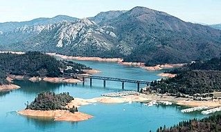
Shasta Dam is a concrete arch-gravity dam across the Sacramento River in Northern California in the United States. At 602 feet (183 m) high, it is the eighth-tallest dam in the United States. Located at the north end of the Sacramento Valley, Shasta Dam creates Shasta Lake for long-term water storage, flood control, hydroelectricity and protection against the intrusion of saline water. The largest reservoir in the state, Shasta Lake can hold about 4,500,000 acre-feet (5,600 GL).

The Pit River is a major river draining from northeastern California into the state's Central Valley. The Pit, the Klamath and the Columbia are the only three rivers in the U.S. that cross the Cascade Range.

The McCloud River is a 77.1-mile (124.1 km) long river that flows east of and parallel to the upper Sacramento River, in Siskiyou County and Shasta County in northern California in the United States. Protected under California's Wild and Scenic Rivers Act (1972), it drains a scenic mountainous area of the Cascade Range, including part of Mount Shasta. It is a tributary of the Pit River, which in turn flows into the Sacramento River. The three rivers join in Shasta Lake, formed by Shasta Dam north of Redding.

Shasta Lake, also popularly known as Lake Shasta, is a reservoir in Shasta County, California, United States. It began to store water in 1944 due to the impounding of the Sacramento River by Shasta Dam, the ninth tallest dam in the United States.

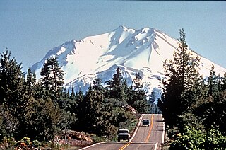
The Shasta–Trinity National Forests are federally designated forests in northern California, United States. Combined, they are the largest National Forest in California and are managed by the U.S. Forest Service. The 2,210,485 acre combined-forest encompasses five wilderness areas, hundreds of mountain lakes and 6,278 miles (10,103 km) of streams and rivers. Major features include Shasta Lake, the largest man-made lake in California and Mount Shasta, elevation 14,179 feet (4,322 m).
The Volcanic Legacy Scenic Byway is a scenic highway and All-American Road in the U.S. states of California and Oregon. It is roughly 500 mi (804.7 km) long and travels north–south along the Cascade Range past numerous volcanoes. It is composed of two separate National Scenic Byways, the Volcanic Legacy Scenic Byway - Oregon and Volcanic Legacy Scenic Byway - California. The latter also wholly includes the Lassen Scenic Byway.

The McCloud Railway was a class III railroad operated around Mount Shasta, California. It began operations on July 1, 1992, when it took over operations from the McCloud River Railroad. The MCR was incorporated on April 21, 1992.

Hat Creek is a 48.7-mile-long (78.4 km) stream and tributary of the Pit River, located in Shasta County of northern California.
Hat Creek is a census designated place (CDP) in Shasta County, California. Hat Creek is situated at an elevation of 3,422 feet (1,043 m). Its population is 266 as of the 2020 census, down from 309 from the 2010 census.

The North Fork Feather River is a watercourse of the northern Sierra Nevada in the U.S. state of California. It flows generally southwards from its headwaters near Lassen Peak to Lake Oroville, a reservoir formed by Oroville Dam in the foothills of the Sierra, where it runs into the Feather River. The river drains about 2,100 square miles (5,400 km2) of the western slope of the Sierras. By discharge, it is the largest tributary of the Feather.
The Pit River Bridge is a double deck, deck truss, road and rail bridge over Shasta Lake in Shasta County, California. The bridge, carrying Interstate 5 on its upper deck and Union Pacific Railroad on its lower deck, was built in 1942 as part of the construction of the Shasta Dam/Shasta Lake reservoir system. The Pit River Bridge was constructed to replace the Lower Pit River Bridge, as the rising waters of the Shasta Lake reservoir would have put the older bridge underwater. The entire bridge spans 3,588 feet (1,094 m) long on the upper deck and 2,754 feet (839 m) on the lower deck. With a height of 500 feet (150 m) above the old Pit River bed, it is structurally the highest double decked bridge in the United States; however, today the bridge sits only about 40 feet (12 m) above the water when Shasta Lake is full.

Pit-3 Dam is a hydroelectric dam on the Pit River in northern California in the United States. It forms Lake Britton, and is owned by the Pacific Gas and Electric Company (PG&E).
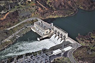
Keswick Dam is a concrete gravity dam on the Sacramento River about 2 miles (3.2 km) northwest of Redding, California. Part of the U.S. Bureau of Reclamation's Central Valley Project, the dam is 157 feet (48 m) high and impounds the Keswick Reservoir, which has a capacity of 23,800 acre⋅ft (29,400,000 m3). The dam's power plant has three turbines with a generating capacity of 117 megawatts (MW), which, in 1992, was uprated from its original 75 MW. The dam and reservoir serve as an afterbay to regulate peaking power releases from the Shasta Dam upstream.


