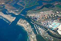
Moss Landing Wildlife Area is a California State wildlife preserve on the shore of Elkhorn Slough.
The Moss Landing Wildlife Area protects 728 acres (295 ha) of Monterey County, California, just north of the town of Moss Landing, California. It includes part of the largest unaltered salt marsh on the California coast. Access is allowed only by foot on trails, and all plants and animals are protected. It is a popular spot for birding and viewing sea otters. [1] Some limited hunting is allowed during certain limited seasons, but rifles or pistols are not allowed. It is administered through the California Department of Fish and Game. [2]
A small strip of the reserve (the easiest to access) lies just east of Highway 1 (called the Cabrillo Highway) at 36°48′44″N121°47′5″W / 36.81222°N 121.78472°W opposite the Moss Landing Yacht Harbor. [3] Other sections lie north of Elkhorn Slough, and west of the slough after it turns to the north, at 36°51′3″N121°45′49″W / 36.85083°N 121.76361°W . To access the north shore section, a trailhead is off Highway 1 between the two intersections of Struve Road, at 36°49′41″N121°46′21″W / 36.82806°N 121.77250°W . A level Marsh Trail runs from this area to a small picnic area, and then the main channel of Elkhorn Slough. [4]
The eastern shore of Elkhorn Slough is protected as part of the Elkhorn Slough National Estuarine Research Reserve. [3] Moss Landing State Beach and Zmudowski State Beach provide access to the Monterey Bay directly west of the wildlife area.
In the late 1800s about 200 acres of what is now the wildlife area were salt evaporation ponds used to commercially produce sea salt for use in local fish canneries. Owned by the Moss Landing Salt Works, [5] the ponds were abandoned in 1974. [6] The wildlife area was established by the state of California in 1984, and was managed in cooperation with the Monterey Bay National Marine Sanctuary when it was established in 1992. [7]
The former salt ponds provide habitat for several shorebird species. The number of western snowy plovers (Charadrius nivosus) nesting in the ponds in spring improved after active management began in 1995 by the Point Reyes Bird Observatory Conservation Science group. [8] [9] [10] [11] [12] [13] In 1999 the ponds were identified as the most critical breeding habitat in the Monterey Bay region for the plovers. In 2006 a managed tidal flow was improved, funded by Ducks Unlimited, the California Wildlife Conservation Board and the National Fish and Wildlife Foundation. [14] In late fall water levels are raised to encourage roosting brown pelicans. [15] In early spring (March or April) the ponds are drained and before the mud dries, volunteers are organized into a "mudstomp" to create shallow impressions as nesting sites. [13]
Binoculars, telescopes, or cameras with telephoto lenses are best used for viewing since observers are restricted from getting too close. [16] [11] Herons, sandpipers, egrets and other waterbirds also are seen in season. [7] The northern entrance and trails can often be closed to public access. [17]
Monterey Bay is a bay of the Pacific Ocean located on the coast of the U.S. state of California, south of the San Francisco Bay Area. San Francisco itself is further north along the coast, by about 75 miles, accessible via CA 1 and US 101.
Moss Landing, formerly Moss, is an unincorporated community and census-designated place (CDP) in Monterey County, California, United States. It is located 18 miles (29 km) north-northeast of Monterey, at an elevation of 10 feet (3.048 m). It is on the shore of Monterey Bay, at the mouth of Elkhorn Slough and at the head of the submarine Monterey Canyon.
The snowy plover is a small shorebird found in the Americas. It is a member of the bird family Charadriidae, which includes the plovers, dotterels, and lapwings. The snowy plover was originally described by John Cassin in 1858, but was classified as a subspecies of the Kentish plover in 1922. Since 2011, the snowy plover has been recognized as a distinct species based on genetic and anatomical differences from the Kentish plover. Two or three subspecies are recognized, distributed along the Pacific coast of North America, Ecuador, Peru, and Chile, in several inland areas of the US and Mexico, along the Gulf Coast, and on Caribbean islands. The coastal populations consist of both residential and migratory birds, whereas the inland populations are mostly migratory. It is one of the best studied endemic shorebirds of the Americas, and one of the rarest.
Zmudowski State Beach is located on Monterey Bay, in Moss Landing, Monterey County, northern California.
Guadalupe-Nipomo Dunes is the largest remaining dune system south of San Francisco and the second largest in the U.S. state of California. It encompasses an 18-mile (29 km) stretch of coastline on the Central Coast of California and extends from southern San Luis Obispo County to northern Santa Barbara County.
The Elkhorn Slough National Estuarine Research Reserve is a nature reserve that is located at 1700 Elkhorn Road in Watsonville, California. The reserve encompasses the central shore of Monterey Bay and is approximately 100 miles (160 km) south of San Francisco, California. The Elkhorn Slough is established as a part of the National Oceanic and Atmospheric Administration and is being managed as the Elkhorn Slough Ecological Reserve through the California Department of Fish and Wildlife.
The Pajaro River is a U.S. river in the Central Coast region of California, forming part of the border between San Benito and Santa Clara Counties, the entire border between San Benito and Santa Cruz County, and the entire border between Santa Cruz and Monterey County. Flowing roughly east to west, the river empties into Monterey Bay, west of Watsonville, California.
Elkhorn Slough is a 7-mile-long (11 km) tidal slough and estuary on Monterey Bay in Monterey County, California. It is California's second largest estuary and the United States' first estuarine sanctuary. The community of Moss Landing and the Moss Landing Power Plant are located at the mouth of the slough on the bay.
Asilomar State Marine Reserve (SMR) is one of four small marine protected areas (MPAs) located near the cities of Monterey and Pacific Grove, at the southern end of Monterey Bay on California’s central coast. The four MPAs together encompass 2.96 square miles (7.7 km2). The SMR protects all marine life within its boundaries. Fishing and take of all living marine resources is prohibited.
Moro Cojo Estuary State Marine Reserve (SMR) is a marine protected area established to protect the wildlife and habitats in Moro Cojo Slough. Moro Cojo Slough is located inland from Monterey Bay on the central coast of California, directly south of the more widely known Elkhorn Slough. The area covers 0.46 square miles (1.2 km2). The SMR protects all marine life within its boundaries. Fishing and take of all living marine resources is prohibited.
The Sonny Bono Salton Sea National Wildlife Refuge is located in the Imperial Valley of California, 40 miles (64 km) north of the Mexican border. Situated at the southern end of the Salton Sea, the refuge protects one of the most important nesting sites and stopovers along the Pacific Flyway. Despite its location in the Colorado Desert, a subdivision of the larger Sonoran Desert, the refuge contains marine, freshwater, wetland, and agricultural habitats which provide sanctuary for hundreds of birds and wetland species, including several that have been listed as endangered or sensitive by the U.S. Fish and Wildlife Service.
Moss Landing State Beach is a state park on Monterey Bay, in Monterey County, California.
Salinas River National Wildlife Refuge is located approximately 11 miles north of Monterey, California, and 3 miles south of Castroville, California, at the point where the Salinas River empties into Monterey Bay. The 367-acre (1.49 km2) refuge encompasses several habitat types including sand dunes, pickleweed salt marsh, river lagoon, riverine habitat, and a saline pond. The refuge was established in 1974 because of its "particular value in carrying out the national migratory bird management program."
Salinas River State Beach is a beach at the river mouth of the Salinas River at Monterey Bay, in Monterey County, California.
Pacific Grove Marine Gardens State Marine Conservation Area is one of four small marine protected areas located near the cities of Monterey and Pacific Grove, at the southern end of Monterey Bay on California’s central coast. The four MPAs together encompass 2.96 square miles (7.7 km2). Within the SMCA fishing and take of all living marine resources is prohibited except the recreational take of finfish and the commercial take of giant and bull kelp by hand under certain conditions. According to the Frommer's guide, the Marine Gardens area is "renowned for ocean views, flowers, and tide-pool seaweed beds."
Portuguese Ledge State Marine Conservation Area (SMCA) is an offshore marine protected area in Monterey Bay. Monterey Bay is on California's central coast with the city of Monterey at its south end and the city of Santa Cruz at its north end. The SMCA covers 10.9 square miles (28 km2). Within the SMCA fishing and take of all living marine resources is prohibited except the commercial and recreational take of pelagic finfish.
Soquel Canyon State Marine Conservation Area (SMCA) is an offshore marine protected area in Monterey Bay. Monterey Bay is on California’s central coast with the city of Monterey at its south end and the city of Santa Cruz at its north end. The SMCA covers 23.41 square miles (60.6 km2). Within the SMCA, fishing and taking of any living marine resources is prohibited except the commercial and recreational take of pelagic finfish.
The western snowy plover is a small wader in the plover bird family. It breeds in the southern and western United States and in Mexico, while its non-breeding range extends to the Gulf Coast and south to Guatemala.
Belmont Slough is a slough on the western shore of San Francisco Bay separating Redwood Shores and Foster City. It provides estuarine and marine deepwater habitats in its subtidal waters, which are characterized as brackish and saltwater.
The San Francisco Bay Salt Ponds are a roughly 16,500-acre (6,700 ha) part of the San Francisco Bay that have been used as salt evaporation ponds since the California Gold Rush era. Most of the ponds were once wetlands in the cities of Redwood City, Newark, and Hayward, and other parts of the bay.