
Shasta County, officially the County of Shasta, is a county located in the northern portion of the U.S. state of California. Its population is 182,155 as of the 2020 census, up from 177,223 from the 2010 census. The county seat is Redding. The County borders Modoc County, Lassen County, Siskiyou County, Plumas County, Tehama County and Trinity County.

Trinity County is a county located in the northwestern portion of the U.S. state of California. Trinity County is rugged, mountainous, heavily forested, and lies along the Trinity River within the Salmon, Klamath Mountains, as well as a portion of the Scott, Trinity, and North Yolla Bolly Mountains. It is also one of three counties in California with no incorporated cities.

The Klamath Mountains are a rugged and lightly populated mountain range in northwestern California and southwestern Oregon in the western United States. As a mountain system within both the greater Pacific Coast Ranges and the California Coast Ranges, the Klamath Mountains have a varied geology, with substantial areas of serpentinite and marble, and a climate characterized by moderately cold winters with very heavy snowfall and warm, very dry summers with limited rainfall, especially in the south. As a consequence of the geology and soil types, the mountains harbor several endemic or near-endemic trees, forming one of the largest collections of conifers in the world. The mountains are also home to a diverse array of fish and animal species, including black bears, large cats, owls, eagles, and several species of Pacific salmon. Millions of acres in the mountains are managed by the United States Forest Service. The northernmost and largest sub-range of the Klamath Mountains are the Siskiyou Mountains.

The Shasta Cascade region of California is located in the northeastern and north-central sections of the state bordering Oregon and Nevada, including far northern parts of the Central Valley and the Sierra Nevada mountain range.

Mount McLoughlin is a dormant steep-sided stratovolcano, or composite volcano, in the Cascade Range of southern Oregon and within the United States Sky Lakes Wilderness. It is one of the volcanic peaks in the Cascade Volcanic Arc, within the High Cascades sector. A prominent landmark for the Rogue River Valley, the mountain is north of Mount Shasta, and south-southwest of Crater Lake. It was named around 1838 after John McLoughlin, a Chief Factor for the Hudson's Bay Company. Mount McLouglin's prominence has made it a landmark to Native American populations for thousands of years.

The Trinity Alps are a mountain range in Trinity County and Siskiyou County in Northern California. They are a subrange of the Klamath Mountains located to the north of Weaverville.
The Shasta–Trinity National Forest is a federally designated forest in northern California, United States. It is the largest National Forest in California and is managed by the U.S. Forest Service. The 2,210,485 acre forest encompasses five wilderness areas, hundreds of mountain lakes and 6,278 miles (10,103 km) of streams and rivers. Major features include Shasta Lake, the largest man-made lake in California and Mount Shasta, elevation 14,179 feet (4,322 m).

The King Range is a mountain range of the Outer Northern California Coast Ranges system, located entirely within Humboldt County on the North Coast of California.

The Trinity Mountains are a subrange of the Klamath Mountains, one of the ranges within the California Coast Ranges and part the greater Pacific Coast Ranges, the coastal mountain system extending from Mexico to Alaska. The Trinity Mountains subrange rises in Siskiyou County and eastern Trinity County, Northern California.

The Chumash Wilderness is a 38,150 acres (15,440 ha) wilderness area within the southern Los Padres National Forest. It is located in the Transverse Ranges, in northern Ventura County and southwestern Kern County in California.

Mount Linn, at 8,098 feet (2,468 m), is the easternmost summit of South Yolla Bolly Mountain, and is located in the Yolla Bolly Mountains of the Northern Coast Ranges and sibling Klamath Mountains System, in Tehama County, northwestern California. Mt. Linn is the highest peak in the northern California Coast Ranges south of the Trinity Alps and, along with the highest peaks of the Trinity Alps, the tallest coastal range peak within the coterminous forty-eight states. Mt. Linn is the third most prominent peak in the northern Pacific Coast Ranges behind Mt. Eddy and Caesar Peaks in the Trinity Alps and Mt. Olympus of Washington's Olympic Mountains.

Mount Eddy is the highest peak of the Trinity Mountains, a mountain range of the Klamath Mountains System, located in Siskiyou County, and Trinity County in northern California.

Castle Lake is a glacial lake located in the Trinity Mountains, in Siskiyou County of northern California. It is west of Mount Shasta City and Mount Shasta peak.
The South Warner Wilderness is a federally designated wilderness area 12 miles (19 km) east of Alturas, California, United States. It encompasses more than 70,000 acres (283 km2) of the Warner Mountains. It is within the Modoc National Forest and managed by the US Forest Service. Elevations range from 5,000 feet (1,500 m) to 9,895 feet at Eagle Peak.
The New River is a 21.4-mile-long (34.4 km) tributary of the Trinity River in northern California. The river was named by miners during the California Gold Rush in the early 1850s. While prospecting west from earlier diggings on the upper Trinity River, they named the river due to it being a "new" place to search for gold.

The Yolla Bolly–Middle Eel Wilderness is a federally designated wilderness area in the Yolla Bolly Range of the southern Klamath Mountains and the Inner Northern California Coast Ranges, in Northern California.
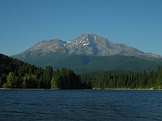
The Mount Shasta Wilderness is a 38,200-acre (155 km2) federally designated wilderness area located 5 miles (8.0 km) east of Mount Shasta City in northern California. The US Congress passed the 1984 California Wilderness Act that set aside the Mount Shasta Wilderness. The US Forest Service is the managing agency as the wilderness is within the Shasta-Trinity National Forest. The area is named for and is dominated by the Mount Shasta volcano which reaches a traditionally quoted height of 14,162 feet (4,317 m) above sea level, but official sources give values ranging from 14,104 feet (4,299 m) from one USGS project, to 14,179 feet (4,322 m) via the NOAA. Mount Shasta is one of only two peaks in the state over 14,000 feet (4,300 m) outside the Sierra Nevada Mountain Range. The other summit is White Mountain Peak in the Great Basin of east-central California.

The Castle Crags Wilderness is a 12,232-acre (49.50 km2) wilderness area in the Castle Crags rock formations of the Trinity Mountains, and within the Shasta-Trinity National Forest, in northwestern California. It is located in Siskiyou County and Shasta County, 40 miles (64 km) north of Redding and south of Mount Shasta City.

The South Fork Trinity River is the main tributary of the Trinity River, in the northern part of the U.S. state of California. It is part of the Klamath River drainage basin. It flows generally northwest from its source in the Klamath Mountains, 92 miles (148 km) through Humboldt and Trinity Counties, to join the Trinity near Salyer. The main tributaries are Hayfork Creek and the East Fork South Fork Trinity River. The river has no major dams or diversions, and is designated Wild and Scenic for its entire length.
North Yolla Bolly Mountain is a 7,868-foot (2,398 m) peak in the Klamath Mountains of the Coast Ranges located in Trinity County, Northern California. The mountain is located in an isolated part of the Yolla Bolly-Middle Eel Wilderness, in the Shasta-Trinity National Forest, about 50 miles (80 km) west of Red Bluff. It is situated about 13 miles (21 km) from Mount Linn, the highest point of the Coast Ranges south of the Trinity Alps.

