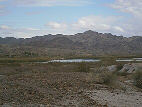
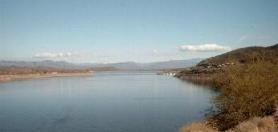
Mittry Lake is located in the Mittry Lake Wildlife Area, just north of Yuma, Arizona, on the Lower Colorado River. It is located in between the upstream Imperial Dam and the downstream Laguna Dam. Mittry Lake comprises about 750 acres (300 ha), with much of the shoreline covered with cattails and bullrush. The lake has undergone rehabilitation work including marsh dredging, revegetation and fish habitat improvement, making it a great location for small game hunting and sport fishing. It is public land managed by the Arizona Game and Fish Department, the Bureau of Reclamation and the Bureau of Land Management, and available to the public for recreational purposes.

The Folsom Lake State Recreation Area surrounds Folsom Lake in the foothills of the Sierra Nevada. The majority of it is owned by the U.S. Bureau of Reclamation and is managed by the California Department of Parks and Recreation. It is located near the city of Folsom, California, about 25 miles (40 km) east of Sacramento.

The Verde River is a major tributary of the Salt River in the U.S. state of Arizona. It is about 170 miles (270 km) long and carries a mean flow of 602 cubic feet per second (17.0 m3/s) at its mouth. It is one of the largest perennial streams in Arizona.
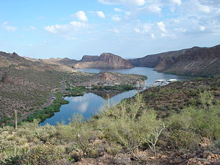
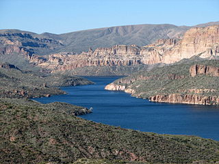
Canyon Lake is one of four reservoirs that were formed by the damming of the Salt River in the U.S. state of Arizona as part of the Salt River Project. It was formed by the Mormon Flat Dam, which was completed in 1925 after two years of construction. Canyon Lake, with a surface area of 950 acres (380 ha), is the third and smallest of the four lakes created along the river. Two others, Apache Lake and Roosevelt Lake, are upstream. The fourth, Saguaro Lake, is downstream.

Lake Pleasant Regional Park is a large outdoors recreation area straddling the Maricopa and Yavapai county border northwest of Phoenix, Arizona. The park is located within the municipal boundaries of Peoria, Arizona, and serves as a major recreation hub for the northwest Phoenix metropolitan area. It is operated by the Maricopa County Parks and Recreation Department.

Lake Havasu is a large reservoir formed by Parker Dam on the Colorado River, on the border between San Bernardino County, California and Mohave County, Arizona. Lake Havasu City sits on the Arizonan side of the lake with its Californian counterpart of Havasu Lake directly across the lake. The reservoir has an available capacity of 619,400 acre-feet (0.7640 km3). The concrete arch dam was built by the United States Bureau of Reclamation between 1934 and 1938. The lake's primary purpose is to store water for pumping into two aqueducts. Prior to the dam construction, the area was home to the Mojave people. The lake was named after the Mojave word for blue. In the early 19th century, it was frequented by beaver trappers. Spaniards also began to mine the areas along the river.

Curecanti National Recreation Area is a National Park Service unit located on the Gunnison River in western Colorado. Established in 1965, Curecanti National Recreation Area is responsible for developing and managing recreational facilities on three reservoirs, Blue Mesa Reservoir, Morrow Point Reservoir and Crystal Reservoir, constructed on the upper Gunnison River in the 1960s by the U.S. Bureau of Reclamation to better utilize the vital waters of the Colorado River and its major tributaries. A popular destination for boating and fishing, Curecanti offers visitors two marinas, traditional and group campgrounds, hiking trails, boat launches, and boat-in campsites. The state's premiere lake trout and Kokanee salmon fisheries, Curecanti is a popular destination for boating and fishing, and is also a popular area for ice-fishing in the winter months.

Lake Mohave is a reservoir on the Colorado River between the Hoover Dam and Davis Dam in Cottonwood Valley defining the border between Nevada and Arizona in the United States. This 67-mile (108 km) stretch of the Colorado River flows past Boulder City, Nelson, Searchlight, Cottonwood Cove, Cal-Nev-Ari, and Laughlin to the west in Nevada and Willow Beach and Bullhead City to the east in Arizona. A maximum width of 4 miles (6.4 km) wide and an elevation of 647 feet (197 m), Lake Mohave encompasses 28,260 acres (114.4 km2) of water. As Lake Mead lies to the north of the Hoover Dam, Lake Mohave and adjacent lands forming its shoreline are part of the Lake Mead National Recreation Area administered by the U.S. National Park Service.

Lynx Lake, Arizona, is a 55-acre (220,000 m2) reservoir located within Prescott National Forest, approximately 5 miles (8.0 km) east of Prescott, Arizona, in the Bradshaw Mountains. The lake is located at 5,530 feet (1,690 m) elevation and is stocked for fishing. It is one of the most popular recreation areas in central Arizona. Mild weather, the cool ponderosa pine forest, trout fishing, boating, mountain hiking, horseback riding, archaeological sites, and bird watching attract visitors from throughout Arizona. The lake was formed in 1952, when a dam was put in Lynx Creek, 6 miles (9.7 km) below Walker, Arizona.

Folsom Lake is a reservoir on the American River in the Sierra Nevada foothills of California, United States. Folsom Lake with its surrounding Folsom Lake State Recreation Area is one of the most visited parks in the California park system.

Lake Perris is an artificial lake completed in 1973. It is the southern terminus of the California State Water Project, situated in a mountain-rimmed valley between Moreno Valley and Perris, in what is now the Lake Perris State Recreation Area. The park offers a variety of recreational activities. Because of this and the lake's proximity to major population centers, it is very crowded during the summer months.
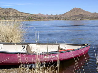
Patagonia Lake State Park is a state park of Arizona, US, containing Patagonia Lake. The 2.5-mile-long (4.0 km), 250-acre (100 ha) lake located near Patagonia, Arizona, is a popular southern Arizona site for fishing, camping, boat rental, picnicking, hiking, and birding. Located inside the park is the recently established Sonoita Creek State Natural Area, Arizona's first major state natural area. Created by the damming of Sonoita Creek, the lake is habitat for reproducing largemouth bass, black crappie, bluegill, green sunfish, flathead catfish, threadfin shad, redear sunfish, channel catfish, and American bullfrogs. Rainbow trout are stocked every three weeks from October to March. Sonoita Creek contains black bullhead, red shiner, mosquitofish, crayfish, American bullfrogs, largemouth bass, Gila topminnows, speckled dace, longfin dace, Sonora suckers, and desert suckers. Special events include an annual mariachi festival in March and bird tours and interpretive programs on request.

Lake Natoma is a small lake in the Western United States, along the lower American River, between Folsom and Nimbus Dams in Sacramento County, California. The lake is located within the Folsom Lake State Recreation Area which maintains the facilities and bike trails surrounding the lake. Lake Natoma is located 15 miles (24 km) east of Sacramento, and has 500 surface acres of water. The total length of lake Natoma is 4 miles (6.4 km).
Fort Custer State Recreation Area is a 3,033-acre (12 km2) State Recreation Area located between Battle Creek and Kalamazoo, Michigan. The area features lakes, the Kalamazoo River, over 25 miles of multi-use trails, second growth oak barrens and dry-mesic southern (oak-hickory) forests.

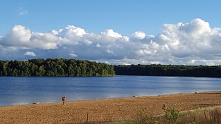
Spruce Run Recreation Area is a 1,290-acre (5.2 km2) New Jersey state recreation area located in Union Township and Clinton Township in Hunterdon County, New Jersey, United States. It encompasses the Spruce Run Reservoir that is used as a backup reservoir to protect the state from prolonged droughts. The reservoir is the third largest in the state, after Round Valley and Wanaque Reservoir. The reservoir is used for recreation purposes, including hunting, fishing, boating and swimming.
Apache Lake is one of four reservoirs built along the Salt River in central Arizona as part of the Salt River Project.
Theodore Roosevelt Lake is a large reservoir formed by Theodore Roosevelt Dam on the Salt River in Arizona as part of the Salt River Project (SRP). Located roughly 80 miles (130 km) northeast of Phoenix in the Salt River Valley, Theodore Roosevelt is the largest lake or reservoir located entirely within the state of Arizona. The reservoir and the masonry dam that created it, Roosevelt Dam, were both named after U.S. President Theodore Roosevelt who dedicated the dam himself on March 18, 1911. Roosevelt Lake is a popular recreation destination within the Tonto National Forest; the facilities located at this lake are managed by that authority.
Picacho is an unincorporated community in Imperial County, California. It is located on the Colorado River 29 miles (47 km) south-southeast of Palo Verde, at an elevation of 203 feet.
Lake Clementine is a reservoir on the North Fork American River Canyon above the picturesque, California Gold Rush-era town of Auburn in Northern California. It was created in 1939 when the North Fork Dam, a 155-foot tall constant angle arch dam, was completed by the United States Army Corps of Engineers, for the purpose of containing gold-mining debris which were washing downriver. This resulting reservoir is a long and narrow lake approximately 3.5 miles long and 300 feet wide in some areas. The lake and surrounding area is owned by the United States Bureau of Reclamation and managed by California Department of Parks and Recreation.

Eisenhower State Park is a state park located in Grayson County, Texas, northwest of Denison, Texas on the shores of Lake Texoma. The park is 423.1 acres (171 ha).