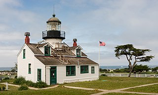
Pacific Grove is a coastal city in Monterey County, California, in the United States. The population at the 2020 census was 15,090. Pacific Grove is located between Point Pinos and Monterey.

Año Nuevo State Park is a state park of California, United States, encompassing Año Nuevo Island and Año Nuevo Point, which are known for their pinniped rookeries. Located in San Mateo County, the low, rocky, windswept point juts out into the Pacific Ocean about 55 miles (89 km) south of San Francisco and the Golden Gate. Año Nuevo State Natural Reserve, formerly a separate unit of the California state park system, was merged into Año Nuevo State Park in October 2008. The coastal geographic center, or coastal-midpoint of California is located at the Northern end of this park at N 37°09′58″, W 122°21'40", as the absolute geographic center of California falls at N 37°09′58″, W 119°26′58″W.

Julia Morgan was an American architect and engineer. She designed more than 700 buildings in California during a long and prolific career. She is best known for her work on Hearst Castle in San Simeon, California.
Asilomar can refer to a number of things:

The Monterey Bay National Marine Sanctuary (MBNMS) is a federally protected marine area offshore of California's Big Sur and central coast in the United States. It is the largest US national marine sanctuary and has a shoreline length of 276 miles (444 km) stretching from just north of the Golden Gate Bridge at San Francisco to Cambria in San Luis Obispo County. Supporting one of the world's most diverse marine ecosystems, it is home to numerous mammals, seabirds, fishes, invertebrates and plants in a remarkably productive coastal environment. The MBNMS was established in 1992 for the purpose of resource protection, research, education, and public use.

Oswald West State Park is part of the state park system of the U.S. state of Oregon. It is located about 10 miles (16 km) south of the city of Cannon Beach, adjacent to Arch Cape, on the Pacific Ocean. The park covers 2,448 acres (9.91 km2), with many miles of hiking trails both inside the park grounds and linking to other parks and landmarks beyond.

William Randolph Hearst Memorial State Beach is located near the historic town of San Simeon along California State Route 1, in San Luis Obispo County, California, United States. It is named for newspaper magnate William Randolph Hearst (1863–1951), whose family is closely associated with the area.

Hearst San Simeon State Park is a state park of California, United States, preserving rocky coast and rare habitats. It is located between Cambria and San Simeon. The 3,409-acre (1,380 ha) park was first established in 1932. The park includes the Santa Rosa Creek Natural Preserve, the San Simeon Natural Preserve and the Pa-nu Cultural Preserve, which were established in 1990.

Asilomar Conference Grounds is a conference center built for the Young Women's Christian Association (YWCA). It is located east of what was known as Moss Beach on the western tip of the Monterey Peninsula in Pacific Grove, California. Between 1913 and 1929 architect Julia Morgan designed and built 16 of the buildings on the property, of which 11 are still standing. In 1956 it became part of the State Division of Beaches and Parks of California's Department of Natural Resources, and Moss Beach was renamed Asilomar State Beach. Asilomar is a derivation of the Spanish phrase asilo al mar, meaning asylum or refuge by the sea. It is the native homeland of the Rumsen Ohlone people.

Asilomar State Marine Reserve (SMR) is one of four small marine protected areas (MPAs) located near the cities of Monterey and Pacific Grove, at the southern end of Monterey Bay on California’s central coast. The four MPAs together encompass 2.96 square miles (7.7 km2). The SMR protects all marine life within its boundaries. Fishing and take of all living marine resources is prohibited.
Plaskett is a thinly populated oceanside hamlet in Pacific Valley, a thin bench of land alongside the Big Sur Coast Highway in the southern Big Sur region of Monterey County, California. It lies at an elevation of 203 feet. It consists of a USFS campground and station, two small resorts, a small school, and a few dozen families spread over the general region.

Stewarts Point State Marine Reserve (SMR) and Stewarts Point State Marine Conservation Area (SMCA) are two adjoining marine protected areas that extend offshore from about a mile south of Black Point to Fisk Mill Cove, in Sonoma County on California’s north central coast. The marine protected areas cover 25.22 square miles. Stewarts Point SMR prohibits the take of all living marine resources. Stewarts Point SMCA prohibits the take of all living marine resources, except recreational shore based take of marine aquatic plants, marine invertebrates, finfish by hook and line, surf smelt by beach net, and species authorized by Title 14 Section 28.80 by hand-held dip net.

Salinas River State Beach is a beach at the river mouth of the Salinas River at Monterey Bay, in Monterey County, California.

Lovers Point State Marine Reserve (SMR) is one of four small marine protected areas located near the cities of Monterey and Pacific Grove, at the southern end of Monterey Bay on California’s central coast. The four MPAs together encompass 2.96 square miles (7.7 km2). The SMR protects all marine life within its boundaries. Fishing and take of all living marine resources is prohibited.

Pacific Grove Marine Gardens State Marine Conservation Area is one of four small marine protected areas located near the cities of Monterey and Pacific Grove, at the southern end of Monterey Bay on California’s central coast. The four MPAs together encompass 2.96 square miles (7.7 km2). Within the SMCA fishing and take of all living marine resources is prohibited except the recreational take of finfish and the commercial take of giant and bull kelp by hand under certain conditions. According to the Frommer's guide, the Marine Gardens area is "renowned for ocean views, flowers, and tide-pool seaweed beds."

Dana Point State Marine Conservation Area (SMCA) is one of four adjoining marine protected areas off the coast of Orange County, CA, on California’s South Coast. By itself, the SMCA measures 3.45 square miles. The SMCA protects marine life by limiting the removal of marine wildlife from within its borders, including tide pools. Dana Point SMCA prohibits take of living marine resources except: only the following species may be taken recreationally below the mean lower low tide line only: finfish by hook-and-line or by spearfishing, and lobster and sea urchin. The commercial take of coastal pelagic species by round haul net, and spiny lobster and sea urchin only is allowed.

Laguna Beach State Marine Reserve (SMR) and Laguna Beach State Marine Conservation Area (SMCA) are two adjoining marine protected areas that extend offshore of Laguna Beach in Orange County on California’s south coast. The SMR covers 6.27 square miles, and the SMCA covers an additional 3.44 square miles. These two MPAs are part of a four-MPA complex on the coast of southern Orange County. Each protects marine life by prohibiting or limiting the removal of marine wildlife from within its borders.


