Monterey is a city in Monterey County on the southern edge of Monterey Bay on the U.S. state of California's Central Coast. Founded on June 3, 1770, it functioned as the capital of Alta California under both Spain (1804–1821) and Mexico (1822–1846). During this period, Monterey hosted California's first theater, public building, public library, publicly funded school, printing press, and newspaper. It was originally the only port of entry for all taxable goods in California. In 1846, during the Mexican–American War of 1846–1848, the United States Flag was raised over the Customs House. After Mexico ceded California to the U.S. at the end of the war, Monterey hosted California's first constitutional convention in 1849.

State Route 1 (SR 1) is a major north–south state highway that runs along most of the Pacific coastline of the U.S. state of California. At 656 miles (1,056 km), it is the longest state route in California, and the second-longest in the US after Montana Highway 200. SR 1 has several portions designated as either Pacific Coast Highway (PCH), Cabrillo Highway, Shoreline Highway, or Coast Highway. Its southern terminus is at Interstate 5 (I-5) near Dana Point in Orange County and its northern terminus is at U.S. Route 101 (US 101) near Leggett in Mendocino County. SR 1 also at times runs concurrently with US 101, most notably through a 54-mile (87 km) stretch in Ventura and Santa Barbara counties, and across the Golden Gate Bridge.

Monterey County, officially the County of Monterey, is a county located on the Pacific coast in the U.S. state of California. As of the 2020 census, its population was 439,035. The county's largest city and county seat is Salinas.

Cannery Row is the waterfront street bordering the city of Pacific Grove, but officially in the New Monterey section of Monterey, California. It was the site of a number of now-defunct sardine canning factories. The last cannery closed in 1973. The street name, formerly a nickname for Ocean View Avenue, became official in January 1958 to honor John Steinbeck and his novel Cannery Row. In the novel's opening sentence, Steinbeck described the street as "a poem, a stink, a grating noise, a quality of light, a tone, a habit, a nostalgia, a dream."

Monterey Bay is a bay of the Pacific Ocean located on the coast of the U.S. state of California, south of the San Francisco Bay Area. San Francisco itself is further north along the coast, by about 75 miles, accessible via CA 1 and US 101.

Northern California is a geographic and cultural region that generally comprises the northern portion of the U.S. state of California, spanning the northernmost 48 of the state's 58 counties. Its main population centers include the San Francisco Bay Area, the Greater Sacramento area, the Redding, California, area south of the Cascade Range, and the Metropolitan Fresno area. Northern California also contains redwood forests, along with most of the Sierra Nevada, including Yosemite Valley and part of Lake Tahoe, Mount Shasta, and most of the Central Valley, one of the world's most productive agricultural regions.

Alviso is a district of San Jose, California, located in North San Jose on the southern shores of San Francisco Bay. Originally an independent town, founded in 1852, today Alviso is San Jose's only waterfront district, primarily residential in nature, with several Silicon Valley tech companies and recreation-oriented businesses. Alviso is named after 19th-century Californio ranchero Ignacio Alviso, who owned the area as part of his Rancho Rincón de Los Esteros.
The Santa Cruz Beach Boardwalk is an oceanfront amusement park in Santa Cruz, California. Founded in 1907, it is California's oldest surviving amusement park and one of the few seaside parks on the West Coast of the United States.

Monterey–Salinas Transit (MST) is the public transit system for Monterey County, California. Service is primarily to the greater Monterey and Salinas areas, but extends as far south as Paso Robles and Big Sur and as far north as Watsonville. Most lines follow a hub-and-spoke system, connecting at hubs in Monterey or Salinas. In 2023, the system had a ridership of 2,470,300, or about 8,100 per weekday as of the fourth quarter of 2023.

Fisherman's Wharf is a historic wharf in Monterey, California, United States. Used as an active wholesale fish market into the 1960s, the wharf eventually became a tourist attraction as commercial fishing tapered off in the area.
The Watsonville Traction Company or Watsonville Transportation Company was a 3 ft narrow gauge, interurban electrified railway in California.
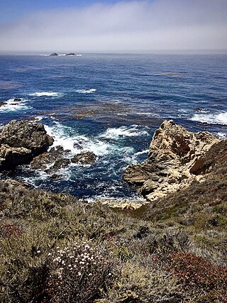
Garrapata State Park is a state park of California, United States, located on California State Route 1 6.7 miles (10.8 km) south of Carmel-by-the-Sea and 18 miles (29 km) north of Big Sur Village on the Monterey coast. The 2,939-acre (1,189 ha) park was established in 1979. California sea lions, harbor seals and sea otters frequent the coastal waters while gray whales pass close by during their yearly migration.
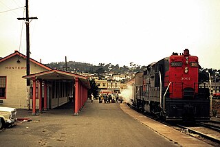
The Del Monte was a passenger train operated by the Southern Pacific Railroad between San Francisco and Monterey, California. It ran from 1889 to 1971.

The Pacific Improvement Company (PIC) was a large holding company in California and an affiliate of the Southern Pacific Railroad. It was formed in 1878, by the Big Four, who were influential businessmen, philanthropists and railroad tycoons who funded the Central Pacific Railroad, (C.P.R.R.). These men were: Leland Stanford (1824–1893), Collis Potter Huntington (1821–1900), Mark Hopkins (1813–1878), and Charles Crocker (1822–1888). They owned the company, each with 25% interest. Archived records date from 1869 to 1931.
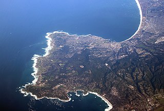
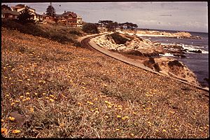
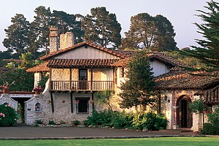
The Monterey Peninsula anchors the northern portion on the Central Coast of California and comprises the cities of Monterey, Carmel, and Pacific Grove, and the resort and community of Pebble Beach.
Old Fisherman's Grotto is a restaurant in Fisherman's Wharf, Monterey, California. Old Fisherman's Grotto was opened in 1950 by restaurateur Sabu Shake, Sr. The restaurant serves seafood, steaks and Italian cuisine. Their Monterey Style Clam Chowder was named best clam chowder in Monterey 15 years in a row.
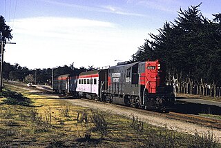
The Monterey Branch Line is a railway line located in Monterey County, California. It runs 16 miles (26 km) between Castroville, where it connects to the Union Pacific Coast Line, and Monterey, formerly running as far as Pacific Grove. It is roughly paralleled by California State Route 1 and is active to Sand City as of 2020.
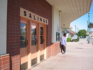
The Monterey County Rail Extension is a planned commuter rail extension that would bring Caltrain passenger service south of its existing Gilroy, California terminus to Salinas in Monterey County, using the existing Coast Line owned by Union Pacific (UPRR). Implementation of the rail extension will occur over three phases, starting from Salinas and moving north. When construction is complete, there will be four trains operated over the extended line per weekday: two northbound trains that depart from Salinas and travel to San Francisco in the morning, and two southbound trains that return to Salinas in the afternoon.

Neponset is an unincorporated community in Monterey County, California. It is located along the Southern Pacific Railroad and California State Route 1 between Marina, California and Castroville, California, and 8.5 miles (14 km) northwest of Salinas, California, at an elevation of 23 feet.