
The Denver and Rio Grande Western Railroad, often shortened to Rio Grande, D&RG or D&RGW, formerly the Denver & Rio Grande Railroad, was an American Class I railroad company. The railroad started as a 3 ft narrow-gauge line running south from Denver, Colorado, in 1870. It served mainly as a transcontinental bridge line between Denver and Ogden, Utah. The Rio Grande was also a major origin of coal and mineral traffic.

Felton is a census-designated place (CDP) in Santa Cruz County, California, United States. The population was 4,489 as of 2020 census and according to the United States Census Bureau, the CDP has a total area of 4.6 square miles (12 km2), all of it land.

James Graham Fair was an Irish immigrant to the United States who became a highly successful mining engineer and businessman. His investments in silver mines in Nevada made him a millionaire, and he was one of the famous "silver kings" who became wealthy on the Comstock Lode. Fair later became a real estate investor and railroad builder in California. In 1881, he was elected a United States Senator from Nevada. Nearly all other major so-called robber barons were Protestants while Fair himself died a Roman Catholic though born into poverty to Anglican parents.

State Route 17 is a state highway in the U.S. state of California that runs from State Route 1 in Santa Cruz to I-280 and I-880 in San Jose. SR 17, a freeway and expressway, carries substantial commuter and vacation traffic through the Santa Cruz Mountains at Patchen Pass between Santa Cruz and the San Francisco Bay Area.

The Santa Cruz, Big Trees and Pacific Railway is operated as a seasonal tourist attraction in Northern California, also referred to as the "Beach Train". Its partner line, the Roaring Camp & Big Trees Narrow Gauge Railroad, is a heritage railroad.

The Roaring Camp & Big Trees Narrow Gauge Railroad is a 3 ft narrow-gauge tourist railroad in California that starts from the Roaring Camp depot in Felton, California and runs up steep grades through redwood forests to the top of nearby Bear Mountain, a distance of 3.25 miles.

Redwood Estates is a rural unincorporated community along State Route 17 in the coastal Santa Cruz Mountains in Los Gatos, California, United States. The Census Bureau includes it in a census-designated place named Lexington Hills. It lies inside the confines of Santa Clara County. The area is about eight miles from downtown Los Gatos and nine miles from the Santa Cruz County community of Scotts Valley.
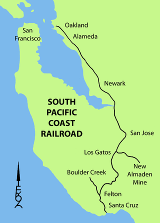
The South Pacific Coast Railroad (SPC) was a 3 ft narrow gauge steam railroad running between Santa Cruz, California, and Alameda, with a ferry connection in Alameda to San Francisco. The railroad was created as the Santa Clara Valley Railroad, founded by local strawberry growers as a way to get their crops to market in San Francisco and provide an alternative to the Southern Pacific Railroad. In 1876, James Graham Fair, a Comstock Lode silver baron, bought the line and extended it into the Santa Cruz Mountains to capture the significant lumber traffic coming out of the redwood forests. The narrow-gauge line was originally laid with 52-pound-per-yard (26 kg/m) rail on 8-foot (2.44 m) redwood ties; and was later acquired by the Southern Pacific and converted to 4 ft 8+1⁄2 instandard gauge.

Wrights, California is a ghost town in unincorporated west Santa Clara County, California. It is located near Summit Road in the Santa Cruz Mountains, on the north bank of Los Gatos Creek, east of State Route 17.

Laurel is a ghost town in Santa Cruz County, California, United States, in the Santa Cruz Mountains. It is in a valley at an elevation of 900 feet (270 m) above sea level.
Lexington, California, is a ghost town in Santa Clara County, now submerged by the Lexington Reservoir. Originally located along Los Gatos Creek, the town was 550 feet above sea level.

Patchen is a ghost town in the Santa Cruz Mountains, in Santa Clara County, California. It is located along the old Santa Cruz Highway.
Clems, California is a ghost town in Santa Cruz County with an elevation of 790 feet. It is located a latitude 37055N, longitude 1215947W; decimal degrees: latitude 37.09806, longitude -121.99639.
Eccles, California is a ghost town in Santa Cruz County, near Felton, east of Ben Lomond. It was near where Lompico Creek flows into Zayante Creek.
The Santa Cruz Railroad was a narrow gauge railroad that ran 21 miles from Santa Cruz to Pajaro, California. It started operation in 1874, running from the east bank of the San Lorenzo River to Soquel, California. With completion of a bridge over the San Lorenzo, it began operation over its full length in 1876 and was sold in foreclosure in 1881.
The Swanton Pacific Railroad Society operated an historic one-third scale, 19 in gauge, railroad at Swanton Pacific Ranch in Davenport, California, 15 miles (24 km) north of Santa Cruz, California. The one-mile (1.6 km)-long railroad lies along the Ocean Shore Railroad right-of-way that was to run from San Francisco to Santa Cruz. The scenic trip, through a valley in the coastal mountains, crosses Scott Creek on the Ed Carnegie Bridge, passes a Christmas tree farm, and ends at a wye where passengers observe railroad operations that turn the locomotive.
Olympia is an unincorporated community in Santa Cruz County, California, located north of Felton on Zayante Creek. Olympia was established after the South Pacific Coast narrow-gauge railroad completed a line over the Santa Cruz Mountains from Los Gatos in 1880. Olympia remained a scheduled stop after the Southern Pacific railroad took over the line in the later 1880s, using it until the line shut down in 1940. A siding served a nearby sand and gravel quarry. In 1915, a post office was closed at Eccles and moved 1/2 mile to Olympia. The name survives in Olympia Station Road, a short dead-end road off Zayante Road that crosses the tracks.

Carter Brothers manufactured railroad cars in northern California during the late 19th century. The firm was founded in 1872 by two Irish carriage-makers who moved to California during the American Civil War. Their cars built more than a century earlier were used into the 21st century on the San Francisco cable car system and the White Pass and Yukon Route.
The Santa Cruz and Monterey Bay Railroad (SCMB), or Santa Cruz Branch Rail Line (SCBRL), is a historic railway running through Santa Cruz County, California. It once ran operationally from Davenport to the Watsonville Junction where it connected to the Union Pacific Coast Line. Over the years it has had many splays and connections to other local railroads over, through, and around the Santa Cruz Mountains. The active line includes a connection with the Roaring Camp Railroads line that makes regular trips between Felton and the Santa Cruz Beach Boardwalk.

The Wrights Tunnel is a railroad tunnel located in the Santa Cruz Mountains in Santa Clara and Santa Cruz Counties, California. Opened in 1880 after almost two years of construction involving numerous fatalities, the tunnel was at one point the longest tunnel in California and one the longest tunnels in the United States. It carried the tracks of the narrow gauge South Pacific Coast Railroad which ran trains from San Francisco to Santa Cruz until the railroad was acquired by Southern Pacific Railroad, which upgraded the tracks to standard gauge and continued operating trains through the line and its tunnel until a major storm in 1940 washed out certain sections of the track in the Santa Cruz Mountains. After two years without rail traffic, Southern Pacific abandoned the line. Subsequently, the United States Army Corps of Engineers collapsed both portals with explosives, destroying the northern portal in the process. The interior of the tunnel remains intact along with the south portal, but the conditions of the interior are unknown, particularly since the tunnel crosses the San Andreas Fault and no person has entered the tunnel in the aftermath of the Loma Prieta earthquake.


