The following outline is provided as an overview of and topical guide to the U.S. state of California:
Contents
- General reference
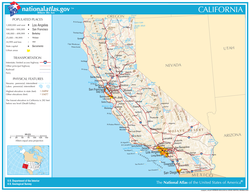
- Geography of California
- Places in California
- Environment of California
- Regions of California
- Administrative divisions of California
- Demography of California
- Geology of California
- Geology of California (general reference)
- Local Geologies of California
- Economic Geology of California
- Geodynamics of California
- Stratigraphy of California
- Physiographic regions of California
- Government and politics of California
- Branches of the government of California
- Law and order in California
- Military in California
- Local government in California
- History of California
- History of California, by period
- History of California, by region
- History of California, by subject
- Culture of California
- The arts in California
- Clubs and Societies in California
- People of California
- Religion in California
- Sports in California
- Economy and infrastructure of California
- Education in California
- See also
- References
- External links
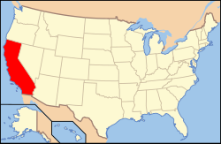
California is the most populous and the third most extensive of the 50 states of the United States of America. California is home to Los Angeles, San Francisco, San Diego, and Sacramento, respectively the 2nd, 6th, 17th, and 23rd most populous metropolitan areas of the United States.
California borders the North Pacific Ocean and Baja California in the Southwestern United States. California includes both Mount Whitney, the highest (4,421 m) mountain peak in the contiguous United States, and Death Valley, the lowest (−86 m) and hottest (56.7 °C) place in North America. California joined the Union as the 31st state on September 9, 1850.