List of mountain ranges of California

Last updated

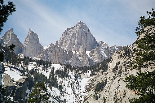
Mount Whitney is the highest mountain peak in the Sierra Nevada, the State of California, and the contiguous United States. Mount Whitney 2003-03-25.jpg
Mount Whitney is the highest mountain peak in the Sierra Nevada, the State of California, and the contiguous United States.

The following list comprises the mountain ranges of U.S. State of California designated by the United States Board on Geographic Names and cataloged in the Geographic Names Information System.

Contents

Mountain ranges

See also

Related Research Articles

<span class="mw-page-title-main">Geography of California</span>

California is a U.S. state on the western coast of North America. Covering an area of 163,696 sq mi (423,970 km2), California is among the most geographically diverse states. The Sierra Nevada, the fertile farmlands of the Central Valley, and the arid Mojave Desert of the south are some of the geographic features of this U.S. state. It is home to some of the world's most exceptional trees: the tallest, most massive, and oldest. It is also home to both the highest and lowest points in the 48 contiguous states.

<span class="mw-page-title-main">Southern California</span> American geographic and cultural region

Southern California is a geographic and cultural region that generally comprises the southern portion of the U.S. state of California. It includes the Los Angeles metropolitan area as well as the Inland Empire. The region generally contains ten of California's 58 counties: Los Angeles, San Diego, Orange, Riverside, San Bernardino, Kern, Ventura, Santa Barbara, San Luis Obispo, and Imperial counties.

<span class="mw-page-title-main">Inyo County, California</span> County in California, United States

Inyo County is a county in the eastern central part of the U.S. state of California, located between the Sierra Nevada and the state of Nevada. In the 2020 census, the population was 19,016. The county seat is Independence. Inyo County is on the east side of the Sierra Nevada and southeast of Yosemite National Park in Central California. It contains the Owens River Valley; it is flanked to the west by the Sierra Nevada and to the east by the White Mountains and the Inyo Mountains. With an area of 10,192 square miles (26,400 km2), Inyo is the second-largest county by area in California, after San Bernardino County. Almost half of that area is within Death Valley National Park. However, with a population density of 1.8 people per square mile, it also has the second-lowest population density in California, after Alpine County.

<span class="mw-page-title-main">Transverse Ranges</span> Group of mountain ranges of southern California

The Transverse Ranges are a group of mountain ranges of southern California, in the Pacific Coast Ranges physiographic region in North America. The Transverse Ranges begin at the southern end of the California Coast Ranges and lie within Santa Barbara, Ventura, Los Angeles, San Bernardino, Riverside and Kern counties. The Peninsular Ranges lie to the south. The name is due to the ranges' east–west orientation, making them transverse to the general northwest–southeast orientation of most of California's coastal mountains.

<span class="mw-page-title-main">Santa Ana Mountains</span> Mountain range in California, United States

The Santa Ana Mountains are a short peninsular mountain range along the coast of Southern California in the United States. They extend for approximately 61 miles (98 km) southeast of the Los Angeles Basin largely along the border between Orange and Riverside counties.

<span class="mw-page-title-main">Dead Mountains</span> Landform in San Bernardino County, California

The Dead Mountains are a mountain range in the southeastern Mojave Desert, in San Bernardino County, California. The range borders the tri-state intersection of Nevada, Arizona and California, and the Mohave Valley, with the Fort Mojave Indian Reservation bordering the range foothills on the east and northeast, in the three states.

<span class="mw-page-title-main">Chuckwalla Mountains</span> Mountain range in California, United States

The Chuckwalla Mountains are a mountain range in the transition zone between the Colorado Desert—Sonoran Desert and the Mojave Desert, climatically and vegetationally, in Riverside County of southern California.

Cottonwood Canyon may refer to:

Districts in California geographically divide the U.S. state into overlapping regions for political and administrative purposes.

<span class="mw-page-title-main">Coyote Mountain (California)</span> Mountain in San Diego County, California, US

Coyote Mountain is a mountain of the Santa Rosa Mountains range, in eastern San Diego County, California.

The Calico Peaks are geologically and historically colorful mountains in the Calico Mountains Range in the Mojave Desert of San Bernardino County and Inyo County, California. They are located just north of Barstow, Yermo, and Interstate 15.

<span class="mw-page-title-main">Outline of California</span> Overview of and topical guide to California

The following outline is provided as an overview of and topical guide to the U.S. state of California:

<span class="mw-page-title-main">Santa Rosa Wilderness</span> Protected wilderness area in California, United States

The Santa Rosa Wilderness is a 72,259-acre (292.42 km2) wilderness area in Southern California, in the Santa Rosa Mountains of Riverside and San Diego counties, California. It is in the Colorado Desert section of the Sonoran Desert, above the Coachella Valley and Lower Colorado River Valley regions in a Peninsular Range, between La Quinta to the north and Anza Borrego Desert State Park to the south. The United States Congress established the wilderness in 1984 with the passage of the California Wilderness Act, managed by both the US Forest Service and the Bureau of Land Management. In 2009, the Omnibus Public Land Management Act was signed into law which added more than 2,000 acres (8.1 km2). Most of the Santa Rosa Wilderness is within the Santa Rosa and San Jacinto Mountains National Monument.

<span class="mw-page-title-main">Temescal Mountains</span> Mountain range of the Peninsular Ranges in Southern California

The Temescal Mountains, also known as the Sierra Temescal, are one of the northernmost mountain ranges of the Peninsular Ranges in western Riverside County, in Southern California in the United States. They extend for approximately 25 mi (40 km) southeast of the Santa Ana River east of the Elsinore Fault Zone to the Temecula Basin and form the western edge of the Perris Block.

The Sierra Peaks Section (SPS) is a mountaineering society within the Angeles Chapter of the Sierra Club that serves to provide mountaineering activities for Sierra Club members in the Sierra Nevada, and to honor mountaineers who have summited Sierra Nevada peaks.

References

    36°34′43″N118°17′31″W / 36.5786°N 118.2920°W / 36.5786; -118.2920 (Mount Whitney)