
Tulare County is a county in the U.S. state of California. As of the 2020 census, the population was 473,117. The county seat is Visalia. The county is named for Tulare Lake, once the largest freshwater lake west of the Great Lakes. Drained for agricultural development, the site is now in Kings County, which was created in 1893 from the western portion of the formerly larger Tulare County.

Lemoore is a city in Kings County, California, United States. Lemoore is located 7.5 miles (12 km) west-southwest of Hanford, at an elevation of 230 feet (70 m). It is part of the Hanford-Corcoran Metropolitan Statistical Area. The inhabitants was 24,531 at the 2010 Census. The California Department of Finance estimated that Lemoore's population was 26,725 on July 1, 2019.

Tulare is a city in Tulare County, California. The population was 69,200 at the 2020 census. It is located in the heart of the San Joaquin Valley, eight miles south of Visalia and sixty miles north of Bakersfield. The city is named for the Tulare Lake, once the largest freshwater lake west of the Great Lakes.

Visalia is a city in the agricultural San Joaquin Valley of California. The population was 141,384 as per the 2020 census. Visalia is the fifth-largest city in the San Joaquin Valley, the 42nd most populous in California, and 192nd in the United States. As the county seat of Tulare County, Visalia serves as the economic and governmental center to one of the most productive agricultural counties in the country.

Tulare Lake is a freshwater dry lake with residual wetlands and marshes in the southern San Joaquin Valley, California, United States. After Lake Cahuilla disappeared in the 17th century, Tulare Lake was the largest freshwater lake west of the Mississippi River and the second-largest freshwater lake entirely in the United States, based upon surface area. A remnant of Pleistocene-era Lake Corcoran, Tulare Lake dried up after its tributary rivers were diverted for agricultural irrigation and municipal water uses.
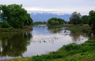
The St. John's River is a distributary of the Kaweah River in the San Joaquin Valley of California in the United States. The river begins at a diversion dam at McKay's Point, about a mile west of Lemon Cove. The distributary flows west along the north side of the city of Visalia, where it joins Elbow Creek, continuing west to Cross Creek.

College of the Sequoias (COS) is a public two-year community college in Visalia, California. The college is named for the Giant Sequoia trees native to the nearby Sierra Nevada mountain range.

Central California is generally thought of as the middle third of the state, north of Southern California, which includes Los Angeles, and south of Northern California, which includes San Francisco. It includes the northern portion of the San Joaquin Valley, part of the Central Coast, the central hills of the California Coast Ranges and the foothills and mountain areas of the central Sierra Nevada.

Allensworth is a census-designated place (CDP) in Tulare County, California. Allensworth sits at an elevation of 213 feet (65 m), the same elevation as the huge and historically important Tulare Lake shore when it was full. The 2010 United States census reported Allensworth's population was 471.

Tulare Union High School is a public school for secondary education in Tulare, Tulare County, California, United States. This high school is part of the Tulare Joint Union High School District, along with Tulare Western High School and Mission Oak High School, led by Superintendent Tony Rodriguez. Enrollment at the four-year high school is approximately 1,650 for the current school year.
Tulare Western High School is a public high school in Tulare, California, United States. Tulare Western's current enrollment is close to 2,100, making it the largest of the three Tulare high schools. The school is part of the Tulare Joint Union High School District, along with Tulare Union High School and Mission Oak High School, headquartered in Tulare, with Lucy Van Scyoc as District Superintendent.

This is a list of the National Register of Historic Places listings in Tulare County, California.
Los Angeles City High School District was a school district that served high school-aged residents of western Los Angeles County, California from 1890 to 1962. At times the district included Beverly Hills, Culver City, and Torrance.

Connie Marie Conway is an American politician serving as the U.S. representative for California's 22nd congressional district since 2022. She served as a member of the California State Assembly from 2008 to 2014. Before that, Conway was a member of the board of supervisors for Tulare County from 2001 until 2008. She is a member of the Republican Party.
There are 45 routes assigned to the "J" zone of the California Route Marker Program, which designates county routes in California. The "J" zone includes county highways in Alameda, Calaveras, Contra Costa, Fresno, Kern, Inyo, Mariposa, Merced, Sacramento, San Benito, San Joaquin, Stanislaus, and Tulare counties.
Rocky Hill is an unincorporated community in Tulare County, California. It lies at an elevation of 1549 feet.
Cutler Park is a large municipal park at the eastern end of Visalia, California near Venice Hills. The park covers 70 acres of land. It is one of the largest Valley Oak Woodlands in Central California.
Porterville Unified School District (PUSD) is a school district located in Porterville, Tulare County, California, and is composed of ten elementary schools, three middle schools, four comprehensive high schools, a continuation school, large adult school, and three alternative program sites. The high schools are accredited and provide academic programs that prepare students for university entrance. Other programs include music, art, agriculture, athletics, and vocational preparation.
Liberty Elementary School District is a public school district based in Tulare County, California, United States. It consists of one school, Liberty Elementary, which is a Kindergarten through 8th grade school. The school's population has seen a recent boom due to a new campus and rapid expansion of the city around the new campus. The district surrounds the other districts of Visalia Unified, Sundale, Tulare City, and Oak Valley.
Buena Vista County was a failed attempt to create a county from the territory of Tulare County, California, between 1855 and 1859.

