List of mountain peaks of Hawaii

Last updated

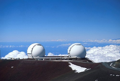
Mauna Kea on the Island of Hawai`i is the highest peak in the U.S. State of Hawai`i and the entire Pacific Ocean. KeckObservatory.jpg
Mauna Kea on the Island of Hawaiʻi is the highest peak in the U.S. State of Hawaiʻi and the entire Pacific Ocean.

The Hawaiian Islands and the U.S. State of Hawaiʻi 13 major mountain peaks [a] with at least 500 meters (1640 feet) of topographic prominence.

Contents

The summit of a mountain or hill may be measured in three principal ways:

  1. The topographic elevation of a summit measures the height of the summit above a geodetic sea level. [1] The first table below ranks the 13 major summits of Hawaiʻi by topographic elevation.
  2. The topographic prominence of a summit is a measure of how high the summit rises above its surroundings. [2] [1] The second table below ranks the 13 major summits of Hawaiʻi by topographic prominence.
  3. The topographic isolation (or radius of dominance) of a summit measures how far the summit lies from its nearest point of equal elevation. [3] The third table below ranks the 13 major summits of Hawaiʻi by topographic isolation.

Highest major summits

Of the 13 major summits of Hawaiʻi, Mauna Kea and Mauna Loa exceed 4000 meters (13,123 feet) elevation, Haleakalā exceeds 3000 meters (9843 feet), Hualalai exceeds 2000 meters (6562 feet), and 11 peaks exceed 1000 meters (3281 feet) elevation.

Four of these peaks rise on the island of Hawaiʻi, two on Maui, two on Kauaʻi, two on Molokaʻi, two on Oʻahu, and one on Lānaʻi.

Of the 13 major summits of Hawaiʻi, Mauna Kea exceeds 4000 meters (13,123 feet) of topographic prominence, Haleakalā exceeds 3000 meters (9843 feet), Mauna Loa exceeds 2000 meters (6562 feet), six peaks are ultra-prominent summits with more than 1500 meters (4921 feet), and eight peaks exceed 1000 meters (3281 feet) of topographic prominence.

Of the 13 major summits of Hawaiʻi, Mauna Kea has 3947 kilometers (2453 miles) of topographic isolation and four peaks exceed 100 kilometers (62.14 miles) of topographic isolation.

The 13 highest summits of Hawaiʻi with at least 500 meters of topographic prominence

Rank Mountain peak Island Elevation Prominence Isolation Location
1 Mauna Kea [4] [5] [6] [7] [b] [c] Flag of Hawaii.svg  Hawaii Island of Hawaiʻi 13,803 ft
4207.3 m
13,803 ft
4207 m
2,453 mi
3,947 km
19°49′15″N155°28′05″W / 19.8207°N 155.4681°W / 19.8207; -155.4681 (Mauna Kea)
2 Mauna Loa [8] [9] [10] [d] [e] Flag of Hawaii.svg  Hawaii Island of Hawaiʻi 13,679 ft
4169 m
7,099 ft
2164 m
25.4 mi
40.8 km
19°28′32″N155°36′19″W / 19.4756°N 155.6054°W / 19.4756; -155.6054 (Mauna Loa)
3 Haleakalā [11] [12] [13] [f] Flag of Hawaii.svg  Hawaii Island of Maui 10,023 ft
3055 m
10,023 ft
3055 m
76.3 mi
122.9 km
20°42′35″N156°15′12″W / 20.7097°N 156.2533°W / 20.7097; -156.2533 (Haleakalā)
4 Hualālai [14] [15] [16] Flag of Hawaii.svg  Hawaii Island of Hawaiʻi 8,271 ft
2521 m
3,091 ft
942 m
22.4 mi
36 km
19°41′20″N155°51′52″W / 19.6889°N 155.8644°W / 19.6889; -155.8644 (Hualālai)
5 Puʻu Kukui [17] [18] [19] Flag of Hawaii.svg  Hawaii Island of Maui 5,788 ft
1764 m
5,678 ft
1731 m
23.5 mi
37.9 km
20°53′25″N156°35′11″W / 20.8904°N 156.5863°W / 20.8904; -156.5863 (Pu'u Kukui)
6 Kaunu o Kaleihoohie [20] [21] [22] Flag of Hawaii.svg  Hawaii Island of Hawaiʻi 5,500 ft
1676 m
2,600 ft
792 m
16.8 mi
27 km
20°05′10″N155°43′02″W / 20.0860°N 155.7171°W / 20.0860; -155.7171 (Kaunu o Kaleihoohie)
7 Kawaikini [23] [24] [25] [g] Flag of Hawaii.svg  Hawaii Island of Kauaʻi 5,243 ft
1598 m
5,243 ft
1598 m
204 mi
328 km
22°03′31″N159°29′50″W / 22.0586°N 159.4973°W / 22.0586; -159.4973 (Kawaikini)
8 Kamakou [26] [27] [28] [h] Flag of Hawaii.svg  Hawaii Island of Molokaʻi 4,961 ft
1512 m
4,961 ft
1512 m
23.5 mi
37.8 km
21°06′23″N156°52′06″W / 21.1065°N 156.8682°W / 21.1065; -156.8682 (Kamakou)
9 Olokuʻi [29] [30] Flag of Hawaii.svg  Hawaii Island of Molokaʻi 4,606 ft
1404 m
1,949 ft
594 m
2.15 mi
3.46 km
21°07′57″N156°50′59″W / 21.1325°N 156.8498°W / 21.1325; -156.8498 (Olokuʻi)
10 Kaʻala [31] [32] [33] [i] Flag of Hawaii.svg  Hawaii Island of Oʻahu 4,060 ft
1237 m
4,060 ft
1237 m
84.4 mi
135.8 km
21°30′28″N158°08′33″W / 21.5079°N 158.1426°W / 21.5079; -158.1426 (Ka'ala)
11 Lānaʻihale [34] [35] [36] [j] Flag of Hawaii.svg  Hawaii Island of Lānaʻi 3,396 ft
1035 m
3,396 ft
1035 m
19.32 mi
31.1 km
20°48′44″N156°52′24″W / 20.8122°N 156.8732°W / 20.8122; -156.8732 (Lānaʻihale)
12 Kōnāhuanui [37] [38] [39] Flag of Hawaii.svg  Hawaii Island of Oʻahu 3,150 ft
960 m
2,303 ft
702 m
23.9 mi
38.5 km
21°21′29″N157°47′18″W / 21.3580°N 157.7882°W / 21.3580; -157.7882 (Kōnāhuanui)
13 Hāʻupu [40] [41] Flag of Hawaii.svg  Hawaii Island of Kauaʻi 2,297 ft
700 m
1,687 ft
514 m
11.02 mi
17.74 km
21°55′31″N159°24′06″W / 21.9254°N 159.4018°W / 21.9254; -159.4018 (Hāʻupu)

See also

Related Research Articles

<span class="mw-page-title-main">Mauna Kea</span> Hawaiian volcano

Mauna Kea is a dormant shield volcano on the island of Hawaiʻi. Its peak is 4,207.3 m (13,803 ft) above sea level, making it the highest point in Hawaii and the island with the second highest high point, behind New Guinea, the world's largest tropical island with multiple peaks that are higher. The peak is about 38 m (125 ft) higher than Mauna Loa, its more massive neighbor. Mauna Kea is unusually topographically prominent for its height: its prominence from sea level is fifteenth in the world among mountains, at 4,207.3 m (13,803 ft); its prominence from under the ocean is 9,330 m (30,610 ft), rivaled only by Mount Everest. This dry prominence is greater than Everest's height above sea level of 8,848.86 m (29,032 ft), and some authorities have labeled Mauna Kea the tallest mountain in the world, from its underwater base. Mauna Kea is ranked 8th by topographic isolation.

<span class="mw-page-title-main">Haleakalā</span> Massive shield volcano in Hawaii

Haleakalā, or the East Maui Volcano, is a massive, active shield volcano that forms more than 75% of the Hawaiian Island of Maui. The western 25% of the island is formed by another volcano, Mauna Kahalawai, also referred to as the West Maui Mountains.

References

  1. 1 2 If the elevation or prominence of a summit is calculated as a range of values, the arithmetic mean is shown.
  2. The topographic prominence of a summit is the topographic elevation difference between the summit and its highest or key col to a higher summit. The summit may be near its key col or quite far away. The key col for Denali in Alaska is the Isthmus of Rivas in Nicaragua, 7642 kilometers (4749 miles) away.
  3. The topographic isolation of a summit is the great-circle distance to its nearest point of equal elevation.
  4. "SUMMIT". Datasheet for NGS Station TU2314. U.S. National Geodetic Survey . Retrieved May 18, 2016.
  5. "Mauna Kea". Geographic Names Information System . United States Geological Survey, United States Department of the Interior.
  6. "Mauna Kea". Peakbagger.com. Retrieved May 18, 2016.
  7. "Mauna Kea". Bivouac.com. Retrieved May 18, 2016.
  8. "Mauna Loa". Geographic Names Information System . United States Geological Survey, United States Department of the Interior.
  9. "Mauna Loa". Peakbagger.com. Retrieved May 18, 2016.
  10. "Mauna Loa". Bivouac.com. Retrieved May 18, 2016.
  11. "Haleakalā". Geographic Names Information System . United States Geological Survey, United States Department of the Interior.
  12. "Haleakalā". Peakbagger.com. Retrieved May 18, 2016.
  13. "Haleakalā". Bivouac.com. Retrieved May 18, 2016.
  14. "Hualālai". Geographic Names Information System . United States Geological Survey, United States Department of the Interior.
  15. "Hualālai". Peakbagger.com. Retrieved May 18, 2016.
  16. "Hualālai". Bivouac.com. Retrieved May 18, 2016.
  17. "Puʻu Kukui". Geographic Names Information System . United States Geological Survey, United States Department of the Interior.
  18. "Puʻu Kukui". Peakbagger.com. Retrieved May 18, 2016.
  19. "Puʻu Kukui". Bivouac.com. Retrieved May 18, 2016.
  20. "Kaunu o Kaleihoohie". Geographic Names Information System . United States Geological Survey, United States Department of the Interior.
  21. "Kaunu o Kaleihoohie". Peakbagger.com. Retrieved May 18, 2016.
  22. "Kaunu o Kaleihoohie". Bivouac.com. Retrieved May 18, 2016.
  23. "Kawaikini". Geographic Names Information System . United States Geological Survey, United States Department of the Interior.
  24. "Kawaikini". Peakbagger.com. Retrieved May 18, 2016.
  25. "Kawaikini". Bivouac.com. Retrieved May 18, 2016.
  26. "Kamakou". Geographic Names Information System . United States Geological Survey, United States Department of the Interior.
  27. "Kamakou". Peakbagger.com. Retrieved May 18, 2016.
  28. "Kamakou". Bivouac.com. Retrieved May 18, 2016.
  29. "Olokuʻi". Geographic Names Information System . United States Geological Survey, United States Department of the Interior.
  30. "Olokuʻi". Peakbagger.com. Retrieved May 18, 2016.
  31. "Kaʻala". Geographic Names Information System . United States Geological Survey, United States Department of the Interior.
  32. "Kaʻala". Peakbagger.com. Retrieved May 18, 2016.
  33. "Kaʻala". Bivouac.com. Retrieved May 18, 2016.
  34. "Lānaʻihale". Geographic Names Information System . United States Geological Survey, United States Department of the Interior.
  35. "Lānaʻihale". Peakbagger.com. Retrieved May 18, 2016.
  36. "Lānaʻihale". Bivouac.com. Retrieved May 18, 2016.
  37. "Kōnāhuanui". Geographic Names Information System . United States Geological Survey, United States Department of the Interior.
  38. "Kōnāhuanui". Peakbagger.com. Retrieved May 18, 2016.
  39. "Kōnāhuanui". Bivouac.com. Retrieved May 18, 2016.
  40. "Hāʻupu". Geographic Names Information System . United States Geological Survey, United States Department of the Interior.
  41. "Hāʻupu". Peakbagger.com. Retrieved May 18, 2016.

Notes

  1. This article defines a significant summit as a summit with at least 100 meters (328.1 feet) of topographic prominence, and a major summit as a summit with at least 500 meters (1640 feet) of topographic prominence. An ultra-prominent summit is a summit with at least 1500 meters (4921 feet) of topographic prominence.
  2. The summit of Mauna Kea is the highest point of the island of Hawaiʻi, the U.S. State of Hawaiʻi, and all islands of the Pacific Ocean.
  3. Mauna Kea is the tallest mountain on Earth as measured from base to summit. The shield volcano sits on the ocean floor at a depth of 5998 meters (19,678 feet) for a total height of 10,205.3 meters (33,482 feet).
  4. Mauna Loa is the southernmost and westernmost 4000-meter (13,123-foot) summit of Hawaiʻi and the United States.
  5. The shield volcano Mauna Loa is the second most voluminous mountain on Earth with an estimated volume of 74,000 cubic kilometres (18,000 cu mi), or enough material to fill the Grand Canyon more than 18 times
  6. The summit of Haleakalā is the highest point of the island of Maui and the westernmost 3000 meter (9842.5-foot) summit of the United States.
  7. The summit of Kawaikini is the highest point of the island of Kauaʻi.
  8. The summit of Kamakou is the highest point of the island of Molokaʻi.
  9. The summit of Kaʻala is the highest point of the island of Oʻahu.
  10. The summit of Lānaʻihale is the highest point of the island of Lānaʻi.

19°49′15″N155°28′05″W / 19.8207°N 155.4681°W / 19.8207; -155.4681 (Mauna Kea)