
Mount Waddington, once known as Mystery Mountain, is the highest peak in the Coast Mountains of British Columbia, Canada. Although it is lower than Mount Fairweather and Mount Quincy Adams, which straddle the United States border between Alaska and British Columbia, Mount Waddington is the highest peak that lies entirely within British Columbia. It and the subrange which surround it, known as the Waddington Range, stand at the heart of the Pacific Ranges, a remote and extremely rugged set of mountains and river valleys.
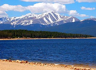
Mount Elbert is the highest summit of the Rocky Mountains of North America. With an elevation of 14,438 feet (4400.58 m), it is also the highest point in the U.S. state of Colorado and the second-highest summit in the contiguous United States after Mount Whitney, which is slightly taller. The ultra-prominent fourteener is the highest peak in the Sawatch Range, as well as the highest point in the entire Mississippi River drainage basin. Mount Elbert is located in San Isabel National Forest, 12.1 miles (19.4 km) southwest of the city of Leadville in Lake County, Colorado.

Mount Saint Elias, the second-highest mountain in both Canada and the United States, stands on the Yukon and Alaska border about 26 miles (42 km) southwest of Mount Logan, the highest mountain in Canada. The Canadian side of Mount Saint Elias forms part of Kluane National Park and Reserve, while the U.S. side of the mountain is located within Wrangell-St. Elias National Park and Preserve.
Mount Hubbard is one of the major mountains of the Saint Elias Range. It is located on the Alaska/Yukon border; the Canadian side is within Kluane National Park and Reserve, and the American side is part of Wrangell–St. Elias National Park. The mountain was named in 1890 by U.S. Geological Survey geologist Israel Russell after Gardiner Greene Hubbard, first president of the National Geographic Society, which had co-sponsored Russell's expedition.

Mount Foraker is a 17,400-foot (5,304 m) mountain in the central Alaska Range, in Denali National Park, 14 mi (23 km) southwest of Denali. It is the second highest peak in the Alaska Range, and the third highest peak in the United States. It rises almost directly above the standard base camp for Denali, on a fork of the Kahiltna Glacier also near Mount Hunter in the Alaska Range.

Mount Stuart is a mountain in the Cascade Range, in the U.S. state of Washington. It is the second highest non-volcanic peak in the state, after Bonanza Peak and seventh-highest overall. Mount Stuart is the highest peak in the Stuart Range, and it is located in the central part of the Washington Cascades, south of Stevens Pass and east of Snoqualmie Pass in the Alpine Lakes Wilderness.

Mount Blackburn is the highest peak in the Wrangell Mountains of Alaska in the United States. It is the fifth-highest peak in the United States and the twelfth-highest peak in North America. The mountain is an old, eroded shield volcano, the second-highest volcano in the U.S. behind Mount Bona and the fifth-highest in North America. It was named in 1885 by Lt. Henry T. Allen of the U.S. Army after Joseph Clay Stiles Blackburn, a U.S. senator from Kentucky. It is located in the heart of Wrangell – St. Elias National Park, the largest national park in the country.

Mount Sanford is a shield volcano in the Wrangell Volcanic Field, in eastern Alaska near the Copper River. It is the sixth highest mountain in the United States and the third highest volcano behind Mount Bona and Mount Blackburn. The south face of the volcano, at the head of the Sanford Glacier, rises 8,000 feet (2,400 m) in 1 mile (1,600 m) resulting in one of the steepest gradients in North America.

Blanca Peak is the fourth highest summit of the Rocky Mountains of North America and the U.S. state of Colorado. The ultra-prominent 14,351-foot (4,374 m) peak is the highest summit of the Sierra Blanca Massif, the Sangre de Cristo Range, and the Sangre de Cristo Mountains. The fourteener is located 9.6 miles (15.5 km) north by east of the Town of Blanca, on the drainage divide separating Rio Grande National Forest and Alamosa County from the Sangre de Cristo Land Grant and Costilla County. The summit is the highest point of both counties and the entire drainage basin of the Rio Grande. Below the steep North Face of Blanca Peak two live Glaciers once developed, until extinction sometime after 1903. North & South Blanca Glaciers were located at 37° 35N.,longitude 105° 28W. Blanca Peak is higher than any point in the United States east of its longitude.

Mount Hayes is the highest mountain in the eastern Alaska Range, in the U.S. state of Alaska. Despite not being a fourteener, it is one of the largest peaks in the United States in terms of rise above local terrain. For example, the Northeast Face rises 8,000 feet (2,440 m) in approximately 2 miles (3.2 km). This large vertical relief contributes to Mount Hayes being the 51st most topographically prominent peak in the world.

Mount Augusta, also designated Boundary Peak 183, is a high peak in the US state of Alaska and the Canadian territory of Yukon. It lies about 25 km (16 mi) south of Mount Logan and 25 km east of Mount Saint Elias, respectively the first and second highest mountains in Canada. Mount Augusta forms the eastern end of the long ridge of which Mount Saint Elias is the center and highest point.

Mount Crillon is a high peak of the Fairweather Range, the southernmost part of the Saint Elias Mountains. It lies southeast of Mount Fairweather, in the promontory between the Gulf of Alaska and Glacier Bay. It is included in Glacier Bay National Park. The peak was named after Felix-Francois-Dorothee de Bretton, Comte de Crillon, by his friend, the French explorer Jean Francois de Galaup de la Perouse.

Mount Bear is a high, glaciated peak in the Saint Elias Mountains of Alaska. It lies within Wrangell-Saint Elias National Park, about 4 miles (6.4 km) west of the Yukon border. The Barnard Glacier flows from its southwest slopes, while the Klutlan Glacier lies to the north. Its principal claim to fame is that it is a fourteener, and in fact one of the highest 20 peaks in the United States.
The Revelation Mountains are a small, rugged subrange of the Alaska Range in Alaska, United States. They mark the furthest western extent of the Alaska Range. The range is rarely visited because of the flying time necessary to get there and also because of the notoriously poor weather conditions that are prevalent in the range. The highest peak in the range is Mount Hesperus.
Mount Natazhat is a high peak of the Saint Elias Mountains, of Alaska, United States, just west of the border with the Yukon Territory of Canada. It lies on the northern edge of the range, south of the White River and north of the Klutlan Glacier. Mount Natazhat is a little-noticed peak; however it is a very large peak in terms of rise above local terrain. It rises 9,000 feet (2,743 m) in less than 7 miles (11.3 km) above the lowlands to the north, and 7,500 feet (2,286 m) in about 4 miles (6.4 km) above the Klutlan Glacier to the south.

Mount Russell is one of the major peaks of the central Alaska Range, approximately 35 mi (56 km) southwest of Denali. Though much lower than Denali or its neighbor Mount Foraker, Russell is a steep, dramatic peak and a significant mountaineering challenge in its own right. To give a sense of its size and steepness, note that its summit rises 6,560 ft (2,000 m) over the Chedotlothna Glacier to the northwest in only 1.8 mi (2.9 km), and almost 10,000 ft (3,000 m) above the lower Yentna Glacier to the south in only 8 mi (13 km).

Pigeon Peak, elevation 13,978 ft (4,260 m), is a summit in the Needle Mountains, a subrange of the San Juan Mountains in the southwestern part of the US State of Colorado. It rises dramatically on the east side of the Animas River, 1.5 miles (2.4 km) west of the fourteener Mount Eolus. It is located in the Weminuche Wilderness, part of the San Juan National Forest.

Mount Drum is a stratovolcano in the Wrangell Mountains of east-central Alaska in the United States. It is located at the extreme western end of the Wrangells, 18 miles (29 km) west-southwest of Mount Sanford and the same distance west-northwest of Mount Wrangell. It lies just inside the western boundary of Wrangell-Saint Elias National Park and Preserve and is 25 miles (40 km) east of the Copper River.

Remmel Mountain, also known as Mount Remmel, is a prominent 8,685-foot (2,647-metre) mountain summit located in Okanogan County in Washington state. It is the highest point in the Cathedral Range, which is a subrange of the Okanogan Range in the North Cascades. The mountain is situated 5 miles (8.0 km) south of the Canada–United States border, on the eastern side of the Cascade crest, in the Pasayten Wilderness, on land managed by the Okanogan–Wenatchee National Forest. The nearest higher peak is Mount Lago, 16.8 miles (27.0 km) to the west-southwest, and Amphitheater Mountain lies 3.6 miles (5.8 km) to the north. Remmel is the third-highest summit of the Okanogan Range following Mount Lago (8,745 ft), and Robinson Mountain (8,726 ft). These three peaks follow Jack Mountain (9,075 ft) as the highest peaks in the Pasayten Wilderness. Remmel is the most prominent mountain in the Pasayten Wilderness. Topographic relief is significant as the summit rises approximately 2,300 feet above Andrews Creek in 0.75 mile (1.2 km). Precipitation runoff from Remmel Mountain drains into the Chewuch River basin.

