Northwest Arctic Borough, Alaska

Last updated

Northwest Arctic Borough
Cape Krusenstern (17915864183).jpg
Northwestarcticboroughseal.jpg
Map of Alaska highlighting Northwest Arctic Borough.svg
Location within the U.S. state of Alaska
Alaska in United States (US50).svg
Alaska's location within the U.S.
Coordinates: 67°N160°W / 67°N 160°W / 67; -160
CountryFlag of the United States.svg United States
StateFlag of Alaska.svg  Alaska
Incorporated June 2, 1986 [1]
Named for Northwest and Arctic location
Seat Kotzebue
Largest cityKotzebue
Government
   Mayor Dickie Moto [2]
Area
  Total40,749 sq mi (105,540 km2)
  Land35,573 sq mi (92,130 km2)
  Water5,176 sq mi (13,410 km2)  12.7%
Population
 (2020)
  Total7,423
  Density0.18/sq mi (0.070/km2)
Time zone UTC−9 (Alaska)
  Summer (DST) UTC−8 (ADT)
Congressional district At-large
Website www.nwabor.org

Northwest Arctic Borough is a borough located in the U.S. state of Alaska. As of the 2020 census, the population was 7,793, [3] up from 7,523 in 2010. [4] The borough seat is Kotzebue. [5] The borough was formed on June 2, 1986.

Contents

Geography

According to the U.S. Census Bureau, the borough has a total area of 40,749 square miles (105,540 km2), of which 35,573 square miles (92,130 km2) is land and 5,176 square miles (13,410 km2) (12.7%) is water. [6] By land area, it is slightly larger than the state of Maine.

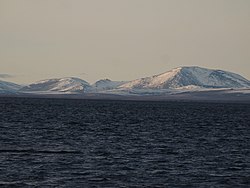
Its coastline is limited by the Chukchi Sea. The Kotzebue Sound, a significant wildlife area, is a prominent water body within the Northwest Arctic Borough. The largest polar bear sighted in history, a male weighing 2,209 pounds (1,002 kg), was sighted at Kotzebue Sound. [7]

Adjacent boroughs and census areas

National protected areas

Politics

United States presidential election results for Northwest Arctic Borough, Alaska [8]
Year Republican Democratic Third party
No.%No.%No.%
2020 73538.58%1,03154.12%1397.30%
2016 56325.79%1,20755.29%41318.92%
2012 61130.52%1,30965.38%824.10%
2008 1,32856.08%95240.20%883.72%
2004 1,12356.21%80140.09%743.70%
2000 1,08150.89%81838.51%22510.59%
1996 78537.72%1,03249.59%26412.69%
1992 87139.99%82537.88%48222.13%
1988 94556.49%66339.63%653.89%
1984 1,14658.89%74538.28%552.83%
1980 58939.69%73249.33%16310.98%
1976 47638.83%71258.08%383.10%
1972 74456.49%55141.84%221.67%
1968 50149.36%46746.01%474.63%
1964 15619.85%63080.15%00.00%
1960 55568.94%25031.06%00.00%

Demographics

Historical population
CensusPop.Note
1960 3,560
1970 4,43424.6%
1980 4,8319.0%
1990 6,11326.5%
2000 7,20817.9%
2010 7,5234.4%
2020 7,7933.6%
2023 (est.)7,361 [9] −5.5%
U.S. Decennial Census [10]
1790-1960 [11] 1900-1990 [12]
1990-2000 [13] 2010-2020 [4]

At the 2000 census, [14] there were 7,208 people, 1,780 households and 1,404 families residing in the borough. The population density was 0.18 per square mile (0.069/km2). There were 2,540 housing units at an average density of 0 per square mile (0/km2). The racial makeup of the borough was 12.32% White, 0.21% Black or African American, 82.46% Native American, 0.89% Asian, 0.06% Pacific Islander, 0.36% from other races, and 3.70% from two or more races. 0.79% of the population were Hispanic or Latino of any race. 40.00% reported speaking Inupiat or "Eskimo" at home. [15]

There were 1,780 households, of which 55.20% had children under the age of 18 living with them, 47.90% were married couples living together, 19.70% had a female householder with no husband present, and 21.10% were non-families. 16.60% of all households were made up of individuals, and 2.10% had someone living alone who was 65 years of age or older. The average household size was 3.87 and the average family size was 4.36. [4]

Age distribution was 41.50% under the age of 18, 10.00% from 18 to 24, 28.10% from 25 to 44, 15.50% from 45 to 64, and 5.00% who were 65 years of age or older. The median age was 24 years. For every 100 females, there were 114.50 males. For every 100 females age 18 and over, there were 120.70 males. [4]

2020 Census

Races (alone or in combination with other) in Northwest Arctic Borough (2020 United States Census) [16]
RacePercentage of Population
White 13.99%
Black or African American 1.72%
American Indian or Alaska Native 88.13%
Asian 1.45%
Native Hawaiian and Other Pacific Islander 0.46%
Some other race0.92%

Communities

Cities

Census-designated places

See also

Related Research Articles

<span class="mw-page-title-main">Bethel Census Area, Alaska</span> Census area in Alaska, United States

Bethel Census Area is a census area in the U.S. state of Alaska. As of the 2020 census, the population is 18,666, up from 17,013 in 2010. It is part of the unorganized borough and therefore has no borough seat. Its largest community is the city of Bethel, which is also the largest city in the unorganized borough.

<span class="mw-page-title-main">Nome Census Area, Alaska</span> Census area in Alaska, United States

Nome Census Area is a census area located in the U.S. state of Alaska, mostly overlapping with the Seward Peninsula. As of the 2020 census, the population was 10,046, up from 9,492 in 2010. It is part of the unorganized borough and therefore has no borough seat. Its largest community by far is the city of Nome.

<span class="mw-page-title-main">North Slope Borough, Alaska</span> Borough in Alaska, United States

The North Slope Borough is the northernmost borough in the US state of Alaska and thus, the northernmost county or equivalent of the United States as a whole. As of the 2020 census, the population was 11,031. The borough seat and largest city, comprising nearly 1/2 of the borough’s population, is Utqiaġvik, the northernmost settlement in the United States.

<span class="mw-page-title-main">Yukon–Koyukuk Census Area, Alaska</span> Census area in Alaska, United States

Yukon–Koyukuk Census Area is a census area in the U.S. state of Alaska. As of the 2020 census, the population was 5,343, down from 5,588 in 2010. With an area of 147,842.51 sq mi (382,910.3 km2), it is the largest of any county or county-equivalent in the United States, or about the same size as the entire state of Montana. It is part of the unorganized borough of Alaska and therefore has no borough seat. Its largest communities are the cities of Galena, in the west, and Fort Yukon, in the northeast.

<span class="mw-page-title-main">Ambler, Alaska</span> City in Alaska, United States

Ambler is a city in Northwest Arctic Borough, Alaska, United States. At the 2010 census the population was 258, down from 309 in 2000. The city is located in the large Iñupiaq language speaking region of Alaska, and the local dialect is known as the Ambler dialect. As of 1999, over 91% of the community speaks and understands the language, with many young children actively learning the language in school. It has important relationships with the "hub" city of Kotzebue, Alaska and has important relationships with Maniilaq Health Association.

<span class="mw-page-title-main">Kobuk, Alaska</span> City in Alaska, United States

Kobuk is a city in Northwest Arctic Borough, Alaska, United States. At the 2010 census the population was 151, up from 109 in 2000.

<span class="mw-page-title-main">Kotzebue, Alaska</span> City in Alaska, United States

Kotzebue or Qikiqtaġruk is a city in the Northwest Arctic Borough in the U.S. state of Alaska. It is the borough's seat, by far its largest community and the economic and transportation hub of the subregion of Alaska encompassing the borough. The population of the city was 3,102 as of the 2020 census, down from 3,201 in 2010.

<span class="mw-page-title-main">Noatak, Alaska</span> Place in Alaska, United States

Noatak is a census-designated place (CDP) in the Northwest Arctic Borough in the U.S. state of Alaska. The population was 570 at the 2020 census, up from 514 in 2010. It is served by Noatak Airport.

<span class="mw-page-title-main">Noorvik, Alaska</span> City in Alaska, United States

Noorvik is an Iñupiat city in the Northwest Arctic Borough in the U.S. state of Alaska. As of the 2020 census, the population of the city was 694, up from 668 in 2010. Located in the NANA Region Corp, Noorvik has close ties with the largest city in the region, Kotzebue. Residents speak a dialect of Iñupiaq known as Noorvik Inupiaq. Noorvik was the first town to be counted in the 2010 census.

<span class="mw-page-title-main">Red Dog Mine, Alaska</span> Census-designated place in Alaska, United States

Red Dog Mine is a census-designated place (CDP) in the Northwest Arctic Borough of the U.S. state of Alaska. The population was 5 at the 2020 census, down from 309 in 2010.

<span class="mw-page-title-main">Selawik, Alaska</span> City in Alaska, United States

Selawik is a city in Northwest Arctic Borough, Alaska, United States. At the 2010 census the population was 829, up from 772 in 2000.

<span class="mw-page-title-main">Shungnak, Alaska</span> City in Alaska, United States

Shungnak is a city in Northwest Arctic Borough, Alaska, United States. At the 2010 census the population was 262, up from 256 in 2000.

<span class="mw-page-title-main">Alatna, Alaska</span> CDP in Alaska, United States

Alatna is a census-designated place (CDP) in the Yukon-Koyukuk Census Area of the Unorganized Borough in the U.S. state of Alaska. The population was 35 at the 2020 census.

<span class="mw-page-title-main">Allakaket, Alaska</span> City in Alaska, United States

Allakaket is a second class city in the Yukon-Koyukuk Census Area of the Unorganized Borough of the U.S. state of Alaska. The population was 105 at the 2010 census.

<span class="mw-page-title-main">Gates of the Arctic National Park and Preserve</span> National park in Alaska, United States

Gates of the Arctic National Park and Preserve is an American national park that protects portions of the Brooks Range in northern Alaska. The park is the northernmost national park in the United States, situated entirely north of the Arctic Circle. The area of the park and preserve is the second largest in the U.S. at 8,472,506 acres ; the National Park portion is the second largest in the U.S., after the National Park portion of Wrangell–St. Elias National Park and Preserve.

<span class="mw-page-title-main">Kobuk Valley National Park</span> National park in Alaska, United States

Kobuk Valley National Park is an American national park in the Arctic region of northwestern Alaska, located about 25 miles (40 km) north of the Arctic Circle. The park was designated in 1980 by the Alaska National Interest Lands Conservation Act to preserve the 100 ft (30 m) high Great Kobuk Sand Dunes and the surrounding area which includes caribou migration routes. Park visitors must bring all their own gear for backcountry camping, hiking, backpacking, boating, and dog sledding. No designated trails or roads exist in the park, which at 1,750,716 acres, is slightly larger than the state of Delaware. Kobuk Valley is one of eight national parks in Alaska, the state with the second most national parks, surpassed only by California which has nine. The park is managed by the National Park Service.

<span class="mw-page-title-main">Hotham Inlet</span>

Hotham Inlet, also known as Kobuk Lake, is an arm of Kotzebue Sound on the northwestern coast of the U.S. state of Alaska. It is 50 miles (80 km) long and 5–20 miles (8–32 km) wide. The inlet is the outlet of the Kobuk and Selawik Rivers and it is bounded on the southwest by the Baldwin Peninsula.

<span class="mw-page-title-main">Noatak National Preserve</span> National Preserve along the Noatak River in northwestern Alaska

Noatak National Preserve is a United States National Preserve in northwestern Alaska that was established to protect the Noatak River Basin. The Noatak River system, located just north of the Arctic Circle, is thought to be the last remaining complete river system in the United States that has not been altered by human activities. The roadless basin was proclaimed a United States National Monument in 1978 and a National Preserve in 1980 through the passage of the Alaska National Interest Lands Conservation Act (ANILCA). Noatak National Preserve borders Kobuk Valley National Park on the south and Gates of the Arctic National Park on the east. Unlike the national parks that it borders, sport hunting is allowed in Noatak National Preserve.

<span class="mw-page-title-main">Selawik National Wildlife Refuge</span> Nature reserve in Alaska

Selawik National Wildlife Refuge in northwest Alaska in the Waring Mountains was officially established in 1980 with the passage of the Alaska National Interest Lands Conservation Act (ANILCA).

<span class="mw-page-title-main">Northwest Arctic Borough School District</span> School district in Alaska, United States

Northwest Arctic Borough School District (NWABSD) is a school district headquartered in Kotzebue, Alaska.

References

  1. 1996 Alaska Municipal Officials Directory. Juneau: Alaska Municipal League/Alaska Department of Community and Regional Affairs. January 1996. p. 14.
  2. "Mayor's Office". Northwest Arctic Borough. January 21, 2016. Retrieved November 16, 2023.
  3. "2020 Census Data - Cities and Census Designated Places" (Web). State of Alaska, Department of Labor and Workforce Development. Retrieved October 31, 2021.
  4. 1 2 3 4 "State & County QuickFacts". United States Census Bureau. Archived from the original on June 29, 2011. Retrieved May 18, 2014.
  5. "Find a County". National Association of Counties. Retrieved June 7, 2011.
  6. "US Gazetteer files: 2010, 2000, and 1990". United States Census Bureau. February 12, 2011. Retrieved April 23, 2011.
  7. C. Michael Hogan (2008) Polar Bear: Ursus maritimus, Globaltwitcher.com, ed. N. Stromberg Archived March 8, 2012, at the Wayback Machine
  8. "RRH Elections". rrhelections.com. February 2, 2018. Retrieved December 24, 2021.
  9. "Annual Estimates of the Resident Population for Counties: April 1, 2020 to July 1, 2023". United States Census Bureau. Retrieved March 28, 2024.
  10. "U.S. Decennial Census". United States Census Bureau. Retrieved May 18, 2014.
  11. "Historical Census Browser". University of Virginia Library. Retrieved May 18, 2014.
  12. "Population of Counties by Decennial Census: 1900 to 1990". United States Census Bureau. Retrieved May 18, 2014.
  13. "Census 2000 PHC-T-4. Ranking Tables for Counties: 1990 and 2000" (PDF). United States Census Bureau. Archived (PDF) from the original on October 9, 2022. Retrieved May 18, 2014.
  14. "U.S. Census website". United States Census Bureau . Retrieved May 14, 2011.
  15. "Modern Language Association". Archived from the original on September 30, 2007. Retrieved January 13, 2007.
  16. "2020 Census Demographic Data Map Viewer".

67°00′N160°00′W / 67.00°N 160.00°W / 67.00; -160.00