Map of the Arctic region, Alaska is in the upper left side, the Arctic Circle is shown in blue.Sign indicating the point where the Dalton Highway crosses the Arctic Circle
Most of northern Alaska has an Arctic climate with long, extremely cold winters and short, cool summers. The average temperatures during the summer months are only several degrees above freezing and the average temperatures during winter are as low as −20 to −30°F (−29 to −34°C), and can dip to −50 to −60°F (−46 to −51°C).
In physical geography, tundra is a type of biome where tree growth is hindered by frigid temperatures and short growing seasons. There are three regions and associated types of tundra: Arctic tundra, alpine tundra, and Antarctic tundra.
The polar climate regions are characterized by a lack of warm summers but with varying winters. Every month a polar climate has an average temperature of less than 10 °C (50 °F). Regions with a polar climate cover more than 20% of the Earth's area. Most of these regions are far from the equator and near the poles, and in this case, winter days are extremely short and summer days are extremely long. A polar climate consists of cool summers and very cold winters, which results in treeless tundras, glaciers, or a permanent or semi-permanent layer of ice. It is identified with the letter E in the Köppen climate classification.
The subarctic climate is a continental climate with long, cold winters, and short, warm to cool summers. It is found on large landmasses, often away from the moderating effects of an ocean, generally at latitudes from 50°N to 70°N, poleward of the humid continental climates. Like other Class D climates, they are rare in the Southern Hemisphere, only found at some isolated highland elevations. Subarctic or boreal climates are the source regions for the cold air that affects temperate latitudes to the south in winter. These climates represent Köppen climate classification Dfc, Dwc, Dsc, Dfd, Dwd and Dsd.
Nome is a city in the Nome Census Area in the Unorganized Borough of the US state of Alaska. The city is located on the southern Seward Peninsula coast on Norton Sound of the Bering Sea. It had a population of 3,699 recorded in the 2020 census, up from 3,598 in 2010. Nome was incorporated on April 9, 1901. It was once the most-populous city in Alaska. Nome lies within the region of the Bering Straits Native Corporation, which is headquartered in Nome.
Utqiagvik, formerly known as Barrow, is the borough seat and largest city of the North Slope Borough in the U.S. state of Alaska. Located north of the Arctic Circle, it is one of the northernmost cities and towns in the world and the northernmost in the United States, with nearby Point Barrow as the country's northernmost point.
Kotzebue or Qikiqtaġruk is a city in the Northwest Arctic Borough in the U.S. state of Alaska. It is the borough's seat, by far its largest community and the economic and transportation hub of the subregion of Alaska encompassing the borough. The population of the city was 3,102 as of the 2020 census, down from 3,201 in 2010.
The Beaufort Sea is a marginal sea of the Arctic Ocean, located north of the Northwest Territories, Yukon, and Alaska, and west of the Canadian Arctic Archipelago. The sea is named after Sir Francis Beaufort, a hydrographer. The Mackenzie River, the longest in Canada, empties into the Canadian part of the Beaufort Sea west of Tuktoyaktuk, which is one of the few permanent settlements on the sea's shores.
The Alaska North Slope is the region of the U.S. state of Alaska located on the northern slope of the Brooks Range along the coast of two marginal seas of the Arctic Ocean, the Chukchi Sea being on the western side of Point Barrow, and the Beaufort Sea on the eastern. With the exception of the highway connecting Fairbanks to Prudhoe Bay, the region is disconnected from the rest of the Alaskan road system and relies mostly on waterways and small airports for transportation due to the Brooks Range secluding the region from the rest of the state.
Kobuk Valley National Park is a national park of the United States in the Arctic region of northwestern Alaska, located about 25 miles (40 km) north of the Arctic Circle. The park was designated in 1980 by the Alaska National Interest Lands Conservation Act to preserve the 100 ft (30 m) high Great Kobuk Sand Dunes and the surrounding area which includes caribou migration routes. Park visitors must bring all their own gear for backcountry camping, hiking, backpacking, boating, and dog sledding. No designated trails or roads exist in the park, which at 1,750,716 acres, is slightly larger than the state of Delaware. Kobuk Valley is one of eight national parks in Alaska, the state with the second most national parks, surpassed only by California which has nine. The park is managed by the National Park Service.
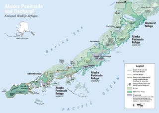
The Alaska Peninsula is a peninsula extending about 497 mi (800 km) to the southwest from the mainland of Alaska and ending in the Aleutian Islands. The peninsula separates the Pacific Ocean from Bristol Bay, an arm of the Bering Sea.
Cape Krusenstern National Monument and the colocated Cape Krusenstern Archeological District is a U.S. National Monument and a National Historic Landmark centered on Cape Krusenstern in northwestern Alaska. The national monument was one of fifteen new National Park Service units designated by the Alaska National Interest Lands Conservation Act (ANILCA) of 1980. It was initially declared a national monument under the authority of the Antiquities Act by President Jimmy Carter on December 1, 1978.
Deadhorse is an unincorporated community located within the CDP of Prudhoe Bay in North Slope Borough, Alaska, United States, along the North Slope near the Arctic Ocean. The town consists mainly of facilities for the workers and companies that operate at the nearby Prudhoe Bay Oil Field. Deadhorse is accessible via the Dalton Highway from Fairbanks, 495 miles (797 km) south, or Deadhorse Airport. Limited accommodation is also available for tourists.
The Bering Land Bridge National Preserve is one of the most remote Protected areas of the United States, located on the Seward Peninsula. The National Preserve protects a remnant of the Bering Land Bridge that connected Asia with North America more than 13,000 years ago during the Pleistocene ice age. The majority of this land bridge now lies beneath the waters of the Chukchi and Bering Seas. During the glacial epoch this bridge was a migration route for people, animals, and plants whenever ocean levels fell enough to expose the land bridge. Archeologists disagree whether it was across this Bering Land Bridge, also called Beringia, that humans first migrated from Asia to populate the Americas, or whether it was via a coastal route.
Umiat (OO-mee-yat) is an unincorporated community in North Slope Borough, Alaska, United States. It is located on the Colville River, 140 miles southwest of Deadhorse in the Arctic Circle. The town is not accessible by road or rail, only by air or river.
Alaska occupies the northwestern portion of the North American continent and is bordered only by Canada on the east. It is one of two U.S. states not bordered by another state; Hawaii is the other. Alaska has more ocean coastline than all of the other U.S. states combined. About 500 miles (800 km) of Canadian territory consisting of British Columbia separate Alaska from Washington U.S. state. Alaska is thus an exclave of the United States that is part of the continental U.S. and the U.S. West Coast, but is not part of the contiguous U.S.
The climate of the United States varies due to changes in latitude, and a range of geographic features, including mountains and deserts. Generally, on the mainland, the climate of the U.S. becomes warmer the farther south one travels, and drier the farther west, until one reaches the West Coast.
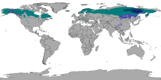
The North American Arctic is composed of the northern polar regions of Alaska (USA), Northern Canada and Greenland. Major bodies of water include the Arctic Ocean, Hudson Bay, the Gulf of Alaska and North Atlantic Ocean. The North American Arctic lies above the Arctic Circle. It is part of the Arctic, which is the northernmost region on Earth. The western limit is the Seward Peninsula and the Bering Strait. The southern limit is the Arctic Circle latitude of 66° 33’N, which is the approximate limit of the midnight sun and the polar night.
The Arctic coastal tundra is an ecoregion of the far north of North America, an important breeding ground for a great deal of wildlife.
Pacific Coastal Mountain icefields and tundra is a tundra ecoregion in Alaska, British Columbia, and Yukon, as defined by the World Wildlife Fund (WWF) categorization system.
The Tundra of North America is a Level I ecoregion of North America designated by the Commission for Environmental Cooperation (CEC) in its North American Environmental Atlas.
This page is based on this Wikipedia article Text is available under the CC BY-SA 4.0 license; additional terms may apply. Images, videos and audio are available under their respective licenses.