Bethel Census Area, Alaska

Last updated

Bethel Census Area
St. Sergius Chapel, Chuathbaluk, Alaska.jpg
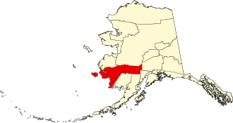
Map of Alaska highlighting Bethel Census Area.svg
Location within the U.S. state of Alaska
Alaska in United States (US50).svg
Alaska's location within the U.S.
Coordinates: 60°45′N160°30′W / 60.75°N 160.5°W / 60.75; -160.5
CountryFlag of the United States.svg United States
StateFlag of Alaska.svg  Alaska
Established1980 [1]
Largest city Bethel
Area
  Total45,504 sq mi (117,850 km2)
  Land40,570 sq mi (105,100 km2)
  Water4,934 sq mi (12,780 km2)  10.8%
Population
 (2020)
  Total18,666
  Estimate 
(2023)
18,224 Decrease2.svg
  Density0.42/sq mi (0.16/km2)
Time zone UTC−9 (Alaska)
  Summer (DST) UTC−8 (ADT)
Congressional district At-large

Bethel Census Area is a census area in the U.S. state of Alaska. As of the 2020 census, the population is 18,666, up from 17,013 in 2010. [2] It is part of the unorganized borough and therefore has no borough seat. Its largest community is the city of Bethel, which is also the largest city in the unorganized borough.

Contents

Geography

According to the United States Census Bureau, the census area has an area of 45,504 square miles (117,850 km2), of which 40,570 square miles (105,100 km2) is land and 4,934 square miles (12,780 km2) (10.8%) is water. [3] Its territory includes the large Nunivak Island in the Bering Sea.

Its land area is comparable to that of Kentucky, which has an area of slightly under forty thousand square miles. [4]

Adjacent boroughs and census areas

National protected areas

Demographics

Historical population
CensusPop.Note
1960 5,537
1970 7,57936.9%
1980 10,99945.1%
1990 13,65624.2%
2000 16,00617.2%
2010 17,0136.3%
2020 18,6669.7%
2023 (est.)18,224 [5] −2.4%
U.S. Decennial Census [6]
1790-1960 [7] 1900-1990 [8]
1990-2000 [9] 2010-2020 [2]

2000 census

As of the census of 2000, there were 16,006 people, 4,226 households, and 3,173 families living in the census area. The population density was 0 people per square mile (0 people/km2). There were 5,188 housing units at an average density of 0 per square mile (0/km2). The racial makeup of the census area was 12.53% White, 0.38% Black or African American, 81.93% Native American, 1.05% Asian, 0.06% Pacific Islander, 0.19% from other races, and 3.85% from two or more races. 0.87% of the population were Hispanic or Latino of any race. [10] Of the 4,226 households, 51.00% had children under the age of 18 living with them, 50.20% were married couples living together, 15.20% had a female householder with no husband present, and 24.90% were non-families. 19.90% of households were one person, and 2.80% were one person aged 65 or older. The average household size was 3.73 and the average family size was 4.41.

In the census area the population was spread out, with 39.80% under the age of 18, 9.70% from 18 to 24, 28.90% from 25 to 44, 16.40% from 45 to 64, and 5.20% 65 or older. The median age was 25 years. For every 100 females, there were 113.20 males. For every 100 females age 18 and over, there were 112.80 males.

Bethel Census Area is one of only 38 county-level census divisions of the United States where the most spoken language is not English and one of only 4 where it is neither English nor Spanish. 63.14% of the population speak a Yupik language at home, followed by English at 34.71%. [11]

Politics

United States presidential election results for Bethel Census Area, Alaska [12]
Year Republican Democratic Third party
No.%No.%No.%
2020 1,67032.70%3,08560.41%3526.89%
2016 1,10322.31%2,71955.00%1,12222.69%
2012 1,15023.90%3,42571.19%2364.91%
2008 2,25043.50%2,69552.10%2284.41%
2004 1,93549.01%1,83246.40%1814.58%
2000 2,02542.10%2,23246.40%55311.50%
1996 1,46730.39%2,79057.80%57011.81%
1992 1,84440.10%1,84040.01%91519.90%
1988 1,95151.79%1,66944.31%1473.90%
1984 2,40251.49%2,10445.10%1593.41%
1980 86025.41%2,06861.09%45713.50%
1976 1,34446.89%1,41049.20%1123.91%
1972 1,03340.57%1,42656.01%873.42%
1968 93939.29%1,29354.10%1586.61%
1964 25713.48%1,64986.52%00.00%
1960 78567.27%38232.73%00.00%

Like most counties or equivalents with a Native American majority, Bethel tends to support Democratic presidential candidates. However, Republican Senator Lisa Murkowski, who has fared well with Alaska Native voters, carried the census area overwhelmingly in 2022.

Communities

Cities

Census-designated places

Unincorporated communities

Education

School districts include: [13]

See also

Related Research Articles

<span class="mw-page-title-main">Aleutians East Borough, Alaska</span> Borough in Alaska, United States

Aleutians East Borough is a 2nd class borough in the U.S. state of Alaska. As of the 2020 census the borough's population was 3,420. The borough seat is Sand Point.

<span class="mw-page-title-main">Aleutians West Census Area, Alaska</span> Census area in Alaska, United States

Aleutians West Census Area is a census area located in the U.S. state of Alaska. As of the 2020 census, the population was 5,232, down from 5,561 in 2010.

<span class="mw-page-title-main">Denali Borough, Alaska</span> Borough in Alaska, United States

The Denali Borough is a borough located in the U.S. state of Alaska. As of the 2020 census the population of the borough was 1,619, down from 1,826 in 2010. The borough seat and most populated community is Healy, and its only incorporated place is Anderson. The borough was incorporated in December 1990.

<span class="mw-page-title-main">Dillingham Census Area, Alaska</span> Census area in Alaska, United States

Dillingham Census Area is a census area located in the state of Alaska, United States. At the 2020 census, the population was 4,857, slightly up from 4,847 in 2010. It is part of the unorganized borough and therefore has no borough seat. Its largest community by far is the city of Dillingham, on a small arm of Bristol Bay on the Bering Sea.

<span class="mw-page-title-main">Kenai Peninsula Borough, Alaska</span> Borough in Alaska, United States

Kenai Peninsula Borough is a borough of the U.S. state of Alaska. As of the 2020 census, the population was 58,799, up from 55,400 in 2010. The borough seat is Soldotna, the largest city is Kenai, and the most populated community is the census-designated place of Kalifornsky.

<span class="mw-page-title-main">Lake and Peninsula Borough, Alaska</span> Borough in Alaska, United States

Lake and Peninsula Borough is a borough in the state of Alaska. As of the 2020 census, the population was 1,476, down from 1,631 in 2010. The borough seat of King Salmon is located in neighboring Bristol Bay Borough, although is not the seat of that borough. The most populous community in the borough is the census-designated place of Port Alsworth. With an average of 0.017 inhabitants per square kilometre, the Lake and Peninsula Borough is the second least densely populated organized county-equivalent in the United States; only the unorganized Yukon-Koyukuk Census Area has a lower density.

<span class="mw-page-title-main">Matanuska-Susitna Borough, Alaska</span> Borough in Alaska, United States

Matanuska-Susitna Borough is a borough located in the U.S. state of Alaska. Its borough seat is Palmer, and the largest community is the census-designated place of Knik-Fairview. As of the 2020 census, the borough's population was 107,801.

<span class="mw-page-title-main">Nome Census Area, Alaska</span> Census area in Alaska, United States

Nome Census Area is a census area located in the U.S. state of Alaska, mostly overlapping with the Seward Peninsula. As of the 2020 census, the population was 10,046, up from 9,492 in 2010. It is part of the unorganized borough and therefore has no borough seat. Its largest community by far is the city of Nome.

<span class="mw-page-title-main">Northwest Arctic Borough, Alaska</span> Borough in Alaska, United States

Northwest Arctic Borough is a borough located in the U.S. state of Alaska. As of the 2020 census, the population was 7,793, up from 7,523 in 2010. The borough seat is Kotzebue. The borough was formed on June 2, 1986.

<span class="mw-page-title-main">Prince of Wales–Hyder Census Area, Alaska</span> Census area in Alaska, United States

Prince of Wales–Hyder Census Area is a census area located in the U.S. state of Alaska. As of the 2020 census, the population was 5,753, up from 5,559 in 2010. It is part of the unorganized borough and therefore has no borough seat. Its largest communities are Metlakatla and Craig. It was formerly part of the Census Bureau's Prince of Wales–Outer Ketchikan Census Area, but the name was changed in 2008 after most of the Outer Ketchikan was lost to annexation by the Ketchikan Gateway Borough.

<span class="mw-page-title-main">Hoonah–Angoon Census Area, Alaska</span> Census area in Alaska, United States

Hoonah–Angoon Census Area is a census area located in the U.S. state of Alaska. As of the 2020 census, the population was 2,365, up from 2,150 in 2010. It is part of the unorganized borough and therefore has no borough seat. Its largest community is the city of Hoonah.

<span class="mw-page-title-main">Valdez–Cordova Census Area, Alaska</span> Census area in Alaska, United States

Valdez–Cordova Census Area was a census area located in the state of Alaska, United States. As of the 2010 census, the population was 9,636. It was part of the Unorganized Borough and therefore had no borough seat. On January 2, 2019, it was abolished and replaced by the Chugach Census Area and the Copper River Census Area.

<span class="mw-page-title-main">Southeast Fairbanks Census Area, Alaska</span> Census area in Alaska, United States

Southeast Fairbanks Census Area is a census area located in the U.S. state of Alaska. As of the 2020 census, the population was 6,808, down from 7,029 in 2010. It is part of the unorganized borough and therefore has no borough seat. Its largest communities are Deltana and Tok, both unincorporated CDPs.

<span class="mw-page-title-main">Kusilvak Census Area, Alaska</span> Census area in Alaska, United States

Kusilvak Census Area, formerly known as Wade Hampton Census Area, is a census area located in the U.S. state of Alaska. As of the 2020 census, the population was 8,368, up from 7,459 in 2010. It is part of the Unorganized Borough and therefore has no borough seat. Its largest community is the city of Hooper Bay, on the Bering Sea coast.

<span class="mw-page-title-main">Yukon–Koyukuk Census Area, Alaska</span> Census area in Alaska, United States

Yukon–Koyukuk Census Area is a census area in the U.S. state of Alaska. As of the 2020 census, the population was 5,343, down from 5,588 in 2010. With an area of 147,842.51 sq mi (382,910.3 km2), it is the largest of any county or county-equivalent in the United States, or slightly larger than the entire state of Montana. It is part of the unorganized borough of Alaska and therefore has no borough seat. Its largest communities are the cities of Galena, in the west, and Fort Yukon, in the northeast.

<span class="mw-page-title-main">Bethel, Alaska</span> City in Alaska, United States

Bethel is a city in the U.S. state of Alaska, located on the Kuskokwim River approximately 50 miles (80 km) from where the river flows into Kuskokwim Bay. It is the largest community in western Alaska and in the Unorganized Borough and the eighth-largest in the state. Bethel has a population of 6,325 as of the 2020 census, up from 6,080 in 2010.

<span class="mw-page-title-main">Mekoryuk, Alaska</span> City in Alaska, United States

Mekoryuk is a city located on Nunivak Island in the Bethel Census Area, Alaska, United States. At the 2010 census the population was 191, down from 210 in 2000.

<span class="mw-page-title-main">Alakanuk, Alaska</span> City in Alaska, United States

Alakanuk(ah-LUG-uh-nuck) is a second class city in the Kusilvak Census Area of the Unorganized Borough in the western part of the U.S. state of Alaska. As of the 2010 census, the population of the city was 677, up from 652 in 2000.

<span class="mw-page-title-main">Nunivak Island</span> Island of Alaska

Nunivak Island is a permafrost-covered volcanic island lying about 30 miles (48 km) offshore from the delta of the Yukon and Kuskokwim rivers in the US state of Alaska, at a latitude of about 60°N. The island is 1,631.97 square miles (4,226.8 km2) in area, making it the second-largest island in the Bering Sea and eighth-largest island in the United States. It is 76.2 kilometers (47.3 mi) long and 106 kilometers (66 mi) wide. It has a population of 191 persons as of the 2010 census, down from 210 in 2000. The island's entire population lives in the north coast city of Mekoryuk.

<span class="mw-page-title-main">Southwest Alaska</span>

Southwest Alaska is a region of the U.S. state of Alaska. The area is not exactly defined by any governmental administrative region(s); nor does it always have a clear geographic boundary.

References

  1. In 1980, the United States Census Bureau divided the Unorganized Borough into 12 census areas.
  2. 1 2 "State & County QuickFacts". United States Census Bureau. Retrieved April 20, 2023.
  3. "US Gazetteer files: 2010, 2000, and 1990". United States Census Bureau. February 12, 2011. Retrieved April 23, 2011.
  4. "United States Summary: 2010, Population and Housing Unit Counts, 2010 Census of Population and Housing" (PDF). United States Census Bureau. September 2012. pp. V-2, 1 & 41 (Tables 1 & 18). Archived (PDF) from the original on October 9, 2022. Retrieved May 23, 2017.
  5. "Annual Estimates of the Resident Population for Counties: April 1, 2020 to July 1, 2023". United States Census Bureau. Retrieved March 28, 2024.
  6. "U.S. Decennial Census". United States Census Bureau. Retrieved May 18, 2014.
  7. "Historical Census Browser". University of Virginia Library. Retrieved May 18, 2014.
  8. "Population of Counties by Decennial Census: 1900 to 1990". United States Census Bureau. Retrieved May 18, 2014.
  9. "Census 2000 PHC-T-4. Ranking Tables for Counties: 1990 and 2000" (PDF). United States Census Bureau. Archived (PDF) from the original on October 9, 2022. Retrieved May 18, 2014.
  10. "U.S. Census website". United States Census Bureau . Retrieved May 14, 2011.
  11. Language Map Data Center. Mla.org (April 3, 2013). Retrieved on August 2, 2013.
  12. Elections, RRH (February 2, 2018). "RRH Elections". rrhelections.com. Retrieved January 12, 2020.
  13. "2020 CENSUS - SCHOOL DISTRICT REFERENCE MAP: Bethel Census Area, AK" (PDF). United States Census Bureau. Archived (PDF) from the original on October 9, 2022. Retrieved July 31, 2022. - Text list

60°45′N160°30′W / 60.750°N 160.500°W / 60.750; -160.500