Matanuska-Susitna Borough, Alaska

Last updated

Matanuska-Susitna Borough
A048, Denali National Park, Alaska, USA, Ruth Glacier and the Great Gorge, 2002.jpg
Flag of Matanuska-Susitna Borough, Alaska.jpg
Seal of Matanuska-Susitna Borough, Alaska.jpg
Map of Alaska highlighting Matanuska-Susitna Borough.svg
Location within the U.S. state of Alaska
Alaska in United States (US50).svg
Alaska's location within the U.S.
Coordinates: 62°24′N149°35′W / 62.4°N 149.58°W / 62.4; -149.58
CountryFlag of the United States.svg United States
StateFlag of Alaska.svg  Alaska
Incorporated January 1, 1964 [1] [2]
Named for Matanuska River and Susitna River
Seat Palmer
Largest CDP Knik-Fairview
Area
  Total25,258 sq mi (65,420 km2)
  Land24,608 sq mi (63,730 km2)
  Water650 sq mi (1,700 km2)  2.6%
Population
 (2020)
  Total107,801
  Estimate 
(2022)
113,325 Increase2.svg
  Density4.3/sq mi (1.6/km2)
Time zone UTC−9 (Alaska)
  Summer (DST) UTC−8 (ADT)
Congressional district At-large
Website www.matsugov.us

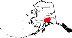
Matanuska-Susitna Borough (often referred to as the Mat-Su Borough) is a borough located in the U.S. state of Alaska. Its borough seat is Palmer, and the largest community is the census-designated place of Knik-Fairview. As of the 2020 census, the borough's population was 107,801. [3]

Contents

The borough is part of the Anchorage Metropolitan Statistical Area, along with the municipality of Anchorage on its south.

The Mat-Su Borough is so designated because it contains the entire Matanuska and Susitna Rivers. They empty into Cook Inlet, which is the southern border of the Mat-Su Borough. It is one of the few agricultural areas of Alaska.

Geography

Mount Bradley in Matanuska-Susitna Borough, Alaska, 2014 Matanuska-Susitna Borough, Alaska.jpg
Mount Bradley in Matanuska-Susitna Borough, Alaska, 2014

The borough seat is Palmer, [4] and the largest community is the census-designated place of Knik-Fairview, Alaska.

As of the 2020 census, the population was 107,081, up from 88,995 in 2010. It is the fastest growing subdivision in Alaska. [5]

According to the United States Census Bureau, the borough has a total area of 25,258 square miles (65,420 km2), of which 24,608 square miles (63,730 km2) is land and 650 square miles (1,700 km2) (2.6%) is water. [6]

Adjacent boroughs and census areas

National protected areas in the borough

Demographics

Historical population
CensusPop.Note
1960 5,188
1970 6,50925.5%
1980 17,816173.7%
1990 39,683122.7%
2000 59,32249.5%
2010 88,99550.0%
2020 107,08120.3%
2023 (est.)115,239 [7] 7.6%
U.S. Decennial Census [8]
1790–1960 [9] 1900–1990 [10]
1990–2000 [11] 2010–2020 [3]

As of the census of 2000, there were 59,322 people, 20,556 households, and 15,046 families residing in the borough. The population density was 2 people per square mile (0.77 people/km2). There were 27,329 housing units at an average density of 1 per square mile (0.39/km2). The racial makeup of the borough was 87.55% White, 0.69% Black or African American, 5.50% Native American, 0.70% Asian, 0.12% Pacific Islander, 0.86% from other races, and 4.57% from two or more races. 2.50% of the population were Hispanic or Latino of any race.

There were 20,556 households, out of which 42.30% had children under the age of 18 living with them, 58.90% were married couples living together, 9.10% had a female householder with no husband present, and 26.80% were non-families. 20.30% of all households were made up of individuals, and 4.10% had someone living alone who was 65 years of age or older. The average household size was 2.84 and the average family size was 3.29.

In the borough the population was spread out, with 32.20% under the age of 18, 7.40% from 18 to 24, 31.10% from 25 to 44, 23.40% from 45 to 64, and 5.90% who were 65 years of age or older. The median age was 34 years. For every 100 females, there were 108.20 males. For every 100 females age 18 and over, there were 108.10 males.

Schools in the borough are administered by the Matanuska-Susitna Borough School District.

Politics and government

The midway area of the Alaska State Fair, held annually in Palmer during late August and early September AKStateFair.jpg
The midway area of the Alaska State Fair, held annually in Palmer during late August and early September
United States presidential election results for Matanuska-Susitna Borough, Alaska [12]
Year Republican Democratic Third party
No.%No.%No.%
2020 38,49271.90%12,84924.00%2,1954.10%
2016 31,94774.39%8,59820.02%2,3985.58%
2012 27,33972.68%9,31724.77%9592.55%
2008 30,24674.50%9,29722.90%1,0562.60%
2004 17,56972.71%6,20125.66%3941.63%
2000 17,97669.31%5,37920.74%2,5799.94%
1996 11,30659.81%4,52223.92%3,07416.26%
1992 7,56439.13%4,37922.66%7,38538.21%
1988 8,85665.01%4,17230.63%5944.36%
1984 9,94473.69%2,94021.79%6104.52%
1980 5,01261.36%1,31616.11%1,84022.53%
1976 2,88460.70%1,48531.26%3828.04%
1972 2,00466.62%69423.07%31010.31%
1968 1,07646.42%89238.48%35015.10%
1964 1,24131.20%2,73768.80%00.00%
1960 1,15252.20%1,05547.80%00.00%

Republicans have carried the borough in every election except for 1964. [13] Matanuska-Susitna Borough has aligned with the statewide presidential election winner in Alaska in every election since 1960, showcasing its bellwether status.

Edna DeVries is the mayor of the Matanuska-Susitna Borough. The borough has a strong-manager form of government. Mike Brown is the borough manager. Long-time Manager John Duffy retired in 2010. [14]

Sarah Palin was previously the mayor of Wasilla, the largest city in the borough.

Communities

Cities

Census-designated places

Other Location

Cyber attack

In July 2018, the borough's computer systems, including the library and animal shelter, were hit by a ransomware attack, forcing employees to do without computers, using electric typewriters where available. [15] The borough declared a state of emergency [16] and incurred over $2 million in costs. [17] The method is thought to have been a targeted phishing e-mail; data left by the malware indicated Mat-Su was the 210th target attacked. [18]

Trimble Glacier 3.jpg
A freshwater pond on Trimble Glacier, in the Tordrillo Mountains, in the far south-west of Mat-Su Borough

See also

Related Research Articles

<span class="mw-page-title-main">Denali Borough, Alaska</span> Borough in Alaska, United States

The Denali Borough is a borough located in the U.S. state of Alaska. As of the 2020 census the population of the borough was 1,619, down from 1,826 in 2010. The borough seat and most populated community is Healy, and its only incorporated place is Anderson. The borough was incorporated in December 1990.

<span class="mw-page-title-main">Kenai Peninsula Borough, Alaska</span> Borough in Alaska, United States

Kenai Peninsula Borough is a borough of the U.S. state of Alaska. As of the 2020 census, the population was 58,799, up from 55,400 in 2010. The borough seat is Soldotna, the largest city is Kenai, and the most populated community is the census-designated place of Kalifornsky.

<span class="mw-page-title-main">Valdez–Cordova Census Area, Alaska</span> Census area in Alaska, United States

Valdez–Cordova Census Area was a census area located in the state of Alaska, United States. As of the 2010 census, the population was 9,636. It was part of the Unorganized Borough and therefore had no borough seat. On January 2, 2019, it was abolished and replaced by the Chugach Census Area and the Copper River Census Area.

<span class="mw-page-title-main">Southeast Fairbanks Census Area, Alaska</span> Census area in Alaska, United States

Southeast Fairbanks Census Area is a census area located in the U.S. state of Alaska. As of the 2020 census, the population was 6,808, down from 7,029 in 2010. It is part of the unorganized borough and therefore has no borough seat. Its largest communities are Deltana and Tok, both unincorporated CDPs.

<span class="mw-page-title-main">Knik River, Alaska</span> CDP in Alaska, United States

Knik River is a census-designated place (CDP) in Matanuska-Susitna Borough in the U.S. state of Alaska. Located 15 miles southeast from Palmer along the Knik River, it is part of the Anchorage, Alaska Metropolitan Statistical Area. The population was 792 at the 2020 census, up from 744 in 2010.

<span class="mw-page-title-main">Knik-Fairview, Alaska</span> CDP in Alaska, United States

Knik-Fairview is a census-designated place (CDP) in Matanuska-Susitna Borough, Alaska, United States. It is part of the Anchorage, Alaska Metropolitan Statistical Area. At the 2020 census the population was 19,297, up from 14,923 in 2010. It is the most populated CDP in Alaska.

<span class="mw-page-title-main">Lake Louise, Alaska</span> Census-designated place in Alaska, United States

Lake Louise is a census-designated place (CDP) in Matanuska-Susitna Borough, Alaska, United States. Although it is an isolated settlement and is close to Glennallen, it is considered part of the Anchorage Metropolitan Area, like all other locations in the Mat-Su Borough. At the 2020 census the population was 15, down from 46 in 2010 and 88 in 2000.

<span class="mw-page-title-main">Lazy Mountain, Alaska</span> CDP in Alaska, United States

Lazy Mountain is a census-designated place (CDP) in Matanuska-Susitna Borough, Alaska, United States. Located east of Palmer along the Matanuska River. At the 2020 census the population was 1,506, up from 1,479 in 2010.

<span class="mw-page-title-main">Palmer, Alaska</span> City in Alaska, United States

Palmer is a city in and the borough seat of the Matanuska-Susitna Borough, Alaska, United States, located 42 miles (68 km) northeast of Anchorage on the Glenn Highway in the Matanuska Valley. It is the ninth-largest city in Alaska, and forms part of the Anchorage Metropolitan Statistical Area. As of the 2020 census, the population of the city is 5,888, down from 5,937 in 2010.

<span class="mw-page-title-main">Petersville, Alaska</span> Census-designated place in Alaska, United States

Petersville is a census-designated place (CDP) in Matanuska-Susitna Borough, Alaska, United States. It is part of the Anchorage Metropolitan Area. The population was 27 at the 2020 census.

<span class="mw-page-title-main">Susitna, Alaska</span> Census-designated place in Alaska, United States

Susitna is a census-designated place (CDP) in Matanuska-Susitna Borough, Alaska, United States. It is part of the Anchorage Metropolitan Area. As of the 2020 census, the population of the CDP was 11.

<span class="mw-page-title-main">Talkeetna, Alaska</span> CDP in Alaska, United States

Talkeetna is a census-designated place (CDP) in Matanuska-Susitna Borough, Alaska, United States. At the 2020 census the population was 1,055, up from 876 in 2010.

<span class="mw-page-title-main">Trapper Creek, Alaska</span> Census-designated place in Alaska, United States

Trapper Creek is a census-designated place (CDP) in Matanuska-Susitna Borough, Alaska, United States. It is part of the Anchorage Metropolitan Area and is known as the southern gateway to Denali State Park. According to the 2020 census the population of Trapper Creek was 499.

<span class="mw-page-title-main">Susitna North, Alaska</span> CDP in Alaska, United States

Susitna North is a census-designated place (CDP) in the Matanuska-Susitna Borough in the U.S. state of Alaska. It is part of the Anchorage, Alaska Metropolitan Statistical Area. The population was 1,564 at the 2020 census, up from 1,260 in 2010. The CDP was formerly named Y, for the intersection of the George Parks Highway and the Talkeetna Spur Road. In the immediate vicinity of this intersection is a community center, containing a health clinic, law enforcement, Susitna Valley High School, and retail services for highway travelers such as gasoline and food.

<span class="mw-page-title-main">Demographics of Alaska</span>

As of 2020, Alaska has a population of 733,391.

<span class="mw-page-title-main">Anchorage metropolitan area</span> Metropolitan area in the U.S. state of Alaska

The Anchorage Metropolitan Statistical Area, as defined by the United States Census Bureau, is an area consisting of the Municipality of Anchorage and the Matanuska-Susitna Borough in the south central region of Alaska.

<span class="mw-page-title-main">Wasilla, Alaska</span> City in Alaska, United States

The City of Wasilla (Dena'ina: Benteh) is a city in Matanuska-Susitna Borough, United States and the fourth-largest city in Alaska. It is located on the northern point of Cook Inlet in the Matanuska-Susitna Valley of the southcentral part of the state. The city's population was 9,054 at the 2020 census, up from 7,831 in 2010. Wasilla is the largest city in the borough and a part of the Anchorage metropolitan area, which had an estimated population of 398,328 in 2020.

<span class="mw-page-title-main">Matanuska-Susitna Valley</span> Valley in Southcentral Alaska, north of Anchorage

Matanuska-Susitna Valley is an area in Southcentral Alaska south of the Alaska Range about 35 miles (56 km) north of Anchorage, Alaska. It is known for the world record sized cabbages and other vegetables displayed annually in Palmer at the Alaska State Fair. It includes the valleys of the Matanuska, Knik, and Susitna Rivers. 11,000 of Mat-Su Valley residents commute to Anchorage for work . It is the fastest growing region in Alaska and includes the towns of Palmer, Wasilla, Big Lake, Houston, Willow, Sutton, and Talkeetna. The Matanuska-Susitna Valley is primarily the land of the Dena'ina and Ahtna Athabaskan people.

North Lakes is a census-designated place (CDP) in Matanuska-Susitna Borough, Alaska, United States. It was first listed as a CDP prior to the 2020 census, after the split of the former CDP of Lakes. It is part of the Anchorage, Alaska Metropolitan Statistical Area.

<span class="mw-page-title-main">South Lakes, Alaska</span> Census-designated place in Alaska, United States

South Lakes is a census-designated place (CDP) in Matanuska-Susitna Borough, Alaska, United States. It was first listed as a CDP prior to the 2020 census, after the split of the former CDP of Lakes. It is part of the Anchorage, Alaska Metropolitan Statistical Area.

References

  1. "History". Matanuska-Susitna Borough Joint Land Use Study. 2009. Archived from the original on March 6, 2012. Retrieved May 4, 2012.
  2. 1996 Alaska Municipal Officials Directory. Juneau: Alaska Municipal League/Alaska Department of Community and Regional Affairs. January 1996. p. 12.
  3. 1 2 "State & County QuickFacts". United States Census Bureau. Retrieved April 13, 2023.
  4. "Find a County". National Association of Counties. Retrieved June 7, 2011.
  5. "2020 Census Data - Cities and Census Designated Places" (Web). State of Alaska, Department of Labor and Workforce Development. Retrieved October 31, 2021.
  6. "US Gazetteer files: 2010, 2000, and 1990". United States Census Bureau. February 12, 2011. Retrieved April 23, 2011.
  7. "Annual Estimates of the Resident Population for Counties: April 1, 2020 to July 1, 2023". United States Census Bureau. Retrieved March 28, 2024.
  8. "U.S. Decennial Census". United States Census Bureau. Retrieved October 31, 2021.
  9. "Historical Census Browser". University of Virginia Library. Retrieved May 17, 2014.
  10. "Population of Counties by Decennial Census: 1900 to 1990". United States Census Bureau. Retrieved May 17, 2014.
  11. "Census 2000 PHC-T-4. Ranking Tables for Counties: 1990 and 2000" (PDF). United States Census Bureau. Archived (PDF) from the original on October 9, 2022. Retrieved May 17, 2014.
  12. Elections, RRH. "RRH Elections". rrhelections.com. Retrieved January 12, 2020.
  13. "Alaska Results by County Equivalent, 1960-2020". April 13, 2021.
  14. Matanuska-Susitna Borough. Matsugov.us. Retrieved on August 2, 2013.
  15. "Town dusts off typewriters after cyber-attack". BBC News. August 1, 2018.
  16. Leroy Polk; Beth Verge (August 2, 2018) [August 1, 2018]. "'This is not somebody in his mother's basement': Massive cyberattack prompts Mat-Su disaster declaration". KTUU.
  17. Zaz Hollander (October 12, 2018) [October 11, 2018]. "Price tag for cyberattack on Mat-Su Borough now tops $2 million". Anchorage Daily News.
  18. Chris Baraniuk (January 9, 2019). "In Depth: The cyber-attack that sent an Alaskan community back in time". BBC News.

62°24′N149°35′W / 62.40°N 149.58°W / 62.40; -149.58