Trapper Creek, Alaska

Last updated

Trapper Creek, Alaska
WalMikes....jpg
Matanuska-Susitna Borough Alaska incorporated and unincorporated areas Trapper Creek highlighted.svg
Location in Matanuska-Susitna Borough and the state of Alaska
USA Alaska location map.svg
Red pog.svg
Trapper Creek
Location within the state of Alaska
Coordinates: 62°18′29″N150°21′3″W / 62.30806°N 150.35083°W / 62.30806; -150.35083
CountryUnited States
State Alaska
Borough Matanuska-Susitna
Government
  Borough mayor Edna DeVries
   State senator Mike Shower (R)
   State rep. Kevin McCabe (R)
Area
[1]
  Total327.81 sq mi (849.02 km2)
  Land320.04 sq mi (828.90 km2)
  Water7.77 sq mi (20.12 km2)
Elevation
351 ft (107 m)
Population
 (2020) [2]
  Total499
  Density1.56/sq mi (0.60/km2)
Time zone UTC-9 (Alaska (AKST))
  Summer (DST) UTC-8 (AKDT)
ZIP code
99683
Area code 907
FIPS code 02-78680
GNIS feature ID1417100

Trapper Creek is a census-designated place (CDP) in Matanuska-Susitna Borough, Alaska, United States. It is part of the Anchorage Metropolitan Area and is known as the southern gateway to Denali State Park. According to the 2020 census the population of Trapper Creek was 499. [2]

Contents

Geography

Trapper Creek is a community located in Matanuska-Susitna Borough at latitude 62.317 and longitude -150.231, with an elevation of 351 ft (107 m). It is at mile 114.5 on the Parks Highway, just south of Denali State Park. Trapper Creek is found at the intersection of Petersville Road and is spread out along the Parks Highway 15 miles (24 km) north of Talkeetna Junction. The Trapper Creek CDP extends west down the Petersville Road, which leads to mining, prospecting, and recreation country in the foothills of the Alaska Range.

According to the United States Census Bureau, the CDP has a total area of 327.8 square miles (849 km2), of which 320.0 square miles (829 km2) are land and 7.8 square miles (20 km2), or 2.37%, are water. [1] The eastern border of the CDP is formed by the Chulitna and Susitna rivers.

Demographics

Historical population
CensusPop.Note
1990 296
2000 42342.9%
2010 48113.7%
2020 4993.7%
U.S. Decennial Census [3]

Trapper Creek first appeared on the 1990 U.S. Census as a census-designated place (CDP).

As of the census [4] of 2000, there were 423 people, 182 households, and 123 families residing in the CDP. The population density was 1.2 inhabitants per square mile (0.46/km2). There were 361 housing units at an average density of 1.0 per square mile (0.39/km2). The racial makeup of the CDP was 87.71% White, 0.24% Black or African American, 8.27% Native American, 0.47% Asian, and 3.31% from two or more races. 1.18% of the population were Hispanic or Latino of any race.

There were 182 households, out of which 24.7% had children under the age of 18 living with them, 52.2% were married couples living together, 8.2% had a female householder with no husband present, and 31.9% were non-families. 28.0% of all households were made up of individuals, and 5.5% had someone living alone who was 65 years of age or older. The average household size was 2.32 and the average family size was 2.74.

In the CDP, the population was spread out, with 22.7% under the age of 18, 5.2% from 18 to 24, 23.6% from 25 to 44, 39.0% from 45 to 64, and 9.5% who were 65 years of age or older. The median age was 44 years. For every 100 females, there were 121.5 males. For every 100 females age 18 and over, there were 125.5 males.

The median income for a household in the CDP was $27,031, and the median income for a family was $34,250. Males had a median income of $65,446 versus $11,250 for females. The per capita income for the CDP was $18,247. About 27.6% of families and 24.7% of the population were below the poverty line, including 16.7% of those under age 18 and 22.6% of those age 65 or over.

Related Research Articles

<span class="mw-page-title-main">Matanuska-Susitna Borough, Alaska</span> Borough in Alaska, United States

Matanuska-Susitna Borough is a borough located in the U.S. state of Alaska. Its borough seat is Palmer, and the largest community is the census-designated place of Knik-Fairview. As of the 2020 census, the borough's population was 107,801.

<span class="mw-page-title-main">Butte, Alaska</span> CDP in Alaska, United States

Butte is a census-designated place (CDP) in Matanuska-Susitna Borough, Alaska, United States. It is part of the Anchorage, Alaska Metropolitan Statistical Area. At the 2020 census, the population was 3,589, up from 3,246 in 2010. Butte is located between the Matanuska River and the Knik River, approximately 5 miles (8 km) southeast of Palmer. It is accessible via the Old Glenn Highway.

<span class="mw-page-title-main">Chase, Alaska</span> CDP in Alaska, United States

Chase is a census-designated place (CDP) in Matanuska-Susitna Borough, Alaska, United States. Located 9.2 miles north from Talkeetna, it is part of the Anchorage, Alaska Metropolitan Statistical Area. The population was 19 at the 2020 census, down from 34 in 2010.

<span class="mw-page-title-main">Chickaloon, Alaska</span> Census-designated place in Matanuska-Susitna Borough, Alaska, United States

Chickaloon is a census-designated place (CDP) in Matanuska-Susitna Borough, Alaska, United States. It is part of the Anchorage, Alaska Metropolitan Statistical Area. The population was 254 at the 2020 census, down from 272 in 2010.

<span class="mw-page-title-main">Fishhook, Alaska</span> CDP in Alaska, United States

Fishhook is a census-designated place (CDP) in Matanuska-Susitna Borough, Alaska, United States. It is part of the Anchorage, Alaska Metropolitan Statistical Area. At the 2020 census the population was 5,048, up from 4,679 in 2010.

<span class="mw-page-title-main">Gateway, Alaska</span> CDP in Alaska, United States

Gateway is a census-designated place (CDP) in Matanuska-Susitna Borough, Alaska, United States. It is part of the Anchorage, Alaska Metropolitan Statistical Area. The population was 5,748 at the 2020 census, up from 5,552 in 2010. Gateway is the fifth-most populated CDP in the borough.

<span class="mw-page-title-main">Glacier View, Alaska</span> Census-designated place in Alaska, United States

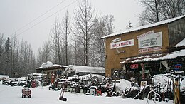
Glacier View is a census-designated place (CDP) in Matanuska-Susitna Borough, Alaska, United States. It is part of the Anchorage Metropolitan Area. At the 2020 census the population was 375, up from 234 in 2010. The terminus of Matanuska Glacier is located approximately three miles southwest of Glacier View.

<span class="mw-page-title-main">Knik River, Alaska</span> CDP in Alaska, United States

Knik River is a census-designated place (CDP) in Matanuska-Susitna Borough in the U.S. state of Alaska. Located 15 miles southeast from Palmer along the Knik River, it is part of the Anchorage, Alaska Metropolitan Statistical Area. The population was 792 at the 2020 census, up from 744 in 2010.

<span class="mw-page-title-main">Lake Louise, Alaska</span> Census-designated place in Alaska, United States

Lake Louise is a census-designated place (CDP) in Matanuska-Susitna Borough, Alaska, United States. Although it is an isolated settlement and is close to Glennallen, it is considered part of the Anchorage Metropolitan Area, like all other locations in the Mat-Su Borough. At the 2020 census the population was 15, down from 46 in 2010 and 88 in 2000.

<span class="mw-page-title-main">Lakes, Alaska</span> CDP in Alaska, United States

Lakes was a census-designated place (CDP) in Matanuska-Susitna Borough, Alaska, United States. It was split in two CDPs for 2020 Census purposes: North Lakes and South Lakes. The area is part of the Anchorage, Alaska Metropolitan Statistical Area. At the 2010 census the population was 8,364, up from 6,706 in 2000.

<span class="mw-page-title-main">Lazy Mountain, Alaska</span> CDP in Alaska, United States

Lazy Mountain is a census-designated place (CDP) in Matanuska-Susitna Borough, Alaska, United States. Located east of Palmer along the Matanuska River. At the 2020 census the population was 1,506, up from 1,479 in 2010.

<span class="mw-page-title-main">Meadow Lakes, Alaska</span> CDP in Alaska, United States

Meadow Lakes is a census-designated place (CDP) in Matanuska-Susitna Borough, Alaska, United States. Located west of Wasilla, it is part of the Anchorage, Alaska Metropolitan Statistical Area. As of the 2020 census, the population was 9,197, up from 7,570 in 2010. It is the fifth-most populated CDP in Alaska and the third largest community in the borough.

<span class="mw-page-title-main">Petersville, Alaska</span> Census-designated place in Alaska, United States

Petersville is a census-designated place (CDP) in Matanuska-Susitna Borough, Alaska, United States. It is part of the Anchorage Metropolitan Area. The population was 27 at the 2020 census.

<span class="mw-page-title-main">Point MacKenzie, Alaska</span> CDP in Alaska, United States

Point MacKenzie is a census-designated place (CDP) in Matanuska-Susitna Borough, Alaska, United States. It is part of the Anchorage, Alaska Metropolitan Statistical Area. At the 2020 census the population was 1,852, up from 529 in 2010.

<span class="mw-page-title-main">Susitna, Alaska</span> Census-designated place in Alaska, United States

Susitna is a census-designated place (CDP) in Matanuska-Susitna Borough, Alaska, United States. It is part of the Anchorage Metropolitan Area. As of the 2020 census, the population of the CDP was 11.

<span class="mw-page-title-main">Sutton-Alpine, Alaska</span> Census-designated place in Alaska, United States

Sutton is a census-designated place (CDP) in the Matanuska-Susitna Borough in the U.S. state of Alaska. At the 2020 census the population was 1,038, down from 1,447 in 2010. The CDP includes the former coal mining community and road construction camp of Sutton, as well as the former mining camps of Eska and Jonesville.

<span class="mw-page-title-main">Talkeetna, Alaska</span> CDP in Alaska, United States

Talkeetna is a census-designated place (CDP) in Matanuska-Susitna Borough, Alaska, United States. At the 2020 census the population was 1,055, up from 876 in 2010.

<span class="mw-page-title-main">Willow, Alaska</span> CDP in Alaska, United States

Willow is a census-designated place (CDP) in the Matanuska-Susitna Borough in the U.S. state of Alaska. Located 26 miles northwest from Wasilla along the George Parks Highway, it is part of the Anchorage, Alaska Metropolitan Statistical Area. At the 2020 census the population was 2,196, up from 2,102 in 2010.

<span class="mw-page-title-main">Susitna North, Alaska</span> CDP in Alaska, United States

Susitna North is a census-designated place (CDP) in the Matanuska-Susitna Borough in the U.S. state of Alaska. It is part of the Anchorage, Alaska Metropolitan Statistical Area. The population was 1,564 at the 2020 census, up from 1,260 in 2010. The CDP was formerly named Y, for the intersection of the George Parks Highway and the Talkeetna Spur Road. In the immediate vicinity of this intersection is a community center, containing a health clinic, law enforcement, Susitna Valley High School, and retail services for highway travelers such as gasoline and food.

<span class="mw-page-title-main">Chalkyitsik, Alaska</span> CDP in Alaska, United States

Chalkyitsik, meaning "to fish with a hook, at the mouth of the creek", is a census-designated place (CDP) in Yukon-Koyukuk Census Area, Alaska, United States. It is located on the left (south) bank of the Black River, 45 miles northeast of Fort Yukon. At the 2010 census the population was 69, down from 83 in 2000.

References

  1. 1 2 "2021 U.S. Gazetteer Files: Alaska". United States Census Bureau. Retrieved May 4, 2022.
  2. 1 2 "Trapper Creek CDP, Alaska: 2020 DEC Redistricting Data (PL 94-171)". U.S. Census Bureau. Retrieved May 4, 2022.
  3. "U.S. Decennial Census". Census.gov. Retrieved June 6, 2013.
  4. "U.S. Census website". United States Census Bureau . Retrieved January 31, 2008.