
Bristol Bay Borough is a borough of the U.S. state of Alaska on Bristol Bay. As of the 2020 census the borough population was 843, down from 997 in 2010, the second-least populated borough in Alaska. The borough seat is Naknek. There are no incorporated settlements.

Naknek is a census-designated place located in and the borough seat of Bristol Bay Borough in the U.S. state of Alaska. As of the 2020 census, the population of the CDP was 470, down from 544 in 2010.

Healy is a census-designated place (CDP) and the borough seat of Denali Borough in the U.S. state of Alaska. The population was 966 at the time of the 2020 census, down from 1,021 in 2010.

Harding-Birch Lakes is a census-designated place (CDP) in Fairbanks North Star Borough, Alaska, United States. It is part of the Fairbanks, Alaska Metropolitan Statistical Area. At the 2010 census the population was 299, up from 216 in 2000.

Mosquito Lake is a census-designated place (CDP) in Haines Borough, Alaska, United States. At the 2010 census the population was 309, up from 221 at the 2000 census.

Bear Creek is a census-designated place (CDP) in Kenai Peninsula Borough, Alaska, United States. At the 2020 census the population was 2,129 up from 1,956 in 2010. Bear Creek is a few miles north of Seward near the stream of the same name and its source, Bear Lake.

Crown Point is a census-designated place (CDP) in Kenai Peninsula Borough, Alaska, United States. The population was 74 at the 2010 census. Land access to this area is by either the Alaska Railroad or the Seward Highway.
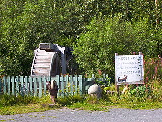
Moose Pass is a census-designated place (CDP) in Kenai Peninsula Borough, Alaska, United States. The population was 219 at the 2010 census, up from 206 in 2000.

Nikiski is a census-designated place (CDP) in Kenai Peninsula Borough, Alaska, United States. The population was 4,456 at the 2020 census, down from 4,493 in 2010.

Primrose is a census-designated place (CDP) in Kenai Peninsula Borough, Alaska, United States. The population was 78 at the 2010 census, down from 93 at the 2000 census. Primrose is one of a number of small communities located north of Seward along the Seward Highway.

Chignik Lake is a census-designated place (CDP) in Lake and Peninsula Borough, Alaska, United States. It is 475 miles (764 km) southwest of Anchorage. At the 2020 census, the population was 61.

Ivanof Bay is a census-designated place (CDP) in Lake and Peninsula Borough, Alaska, United States. The population was just one at the 2020 census, down from seven in 2010.
Kokhanok is a census-designated place (CDP) in Lake and Peninsula Borough, Alaska, United States. At the 2020 census the population was 152, down from 170 in 2000.

Big Lake is a census-designated place (CDP) in Matanuska-Susitna Borough, Alaska, United States. It is part of the Anchorage, Alaska Metropolitan Statistical Area. The population was 3,833 at the 2020 census, up from 3,350 in 2010.

Lake Louise is a census-designated place (CDP) in Matanuska-Susitna Borough, Alaska, United States. Although it is an isolated settlement and is close to Glennallen, it is considered part of the Anchorage Metropolitan Area, like all other locations in the Mat-Su Borough. At the 2020 census the population was 15, down from 46 in 2010 and 88 in 2000.

Lakes was a census-designated place (CDP) in Matanuska-Susitna Borough, Alaska, United States. It was split in two CDPs for 2020 Census purposes: North Lakes and South Lakes. The area is part of the Anchorage, Alaska Metropolitan Statistical Area. At the 2010 census the population was 8,364, up from 6,706 in 2000.

Meadow Lakes is a census-designated place (CDP) in Matanuska-Susitna Borough, Alaska, United States. Located west of Wasilla, it is part of the Anchorage, Alaska Metropolitan Statistical Area. As of the 2020 census, the population was 9,197, up from 7,570 in 2010. It is the fifth-most populated CDP in Alaska and the third largest community in the borough.

Steele Creek is a census-designated place (CDP) in Fairbanks North Star Borough, Alaska, United States. It is part of the Fairbanks, Alaska Metropolitan Statistical Area. As of the 2020 census, the population was 6,437, down from 6,662 in 2010. It is the eighth-most populated CDP in Alaska.
North Lakes is a census-designated place (CDP) in Matanuska-Susitna Borough, Alaska, United States. It was first listed as a CDP prior to the 2020 census, after the split of the former CDP of Lakes. It is part of the Anchorage, Alaska Metropolitan Statistical Area.


