Petersville, Alaska

Last updated

Petersville, Alaska
Matanuska-Susitna Borough Alaska incorporated and unincorporated areas Petersville highlighted.svg
Location in Matanuska-Susitna Borough and the state of Alaska
USA Alaska location map.svg
Red pog.svg
Petersville
Location within the state of Alaska
Coordinates: 62°22′37″N150°44′49″W / 62.37694°N 150.74694°W / 62.37694; -150.74694
CountryUnited States
State Alaska
Borough Matanuska-Susitna
Government
  Borough mayor Edna DeVries
   State senator Mike Shower (R)
   State rep. Kevin McCabe (R)
Area
[1]
  Total462.50 sq mi (1,197.87 km2)
  Land461.83 sq mi (1,196.14 km2)
  Water0.67 sq mi (1.72 km2)
Elevation
1,617 ft (493 m)
Population
 (2020) [2]
  Total27
  Density0.06/sq mi (0.02/km2)
Time zone UTC-9 (Alaska (AKST))
  Summer (DST) UTC-8 (AKDT)
Area code 907
FIPS code 02-60460
GNIS feature ID1407927

Petersville is a census-designated place (CDP) in Matanuska-Susitna Borough, Alaska, United States. It is part of the Anchorage Metropolitan Area. The population was 27 at the 2020 census. [2]

Contents

Geography

Petersville is located in the northwest part of Matanuska-Susitna Borough at 62°22′37″N150°44′49″W / 62.37694°N 150.74694°W / 62.37694; -150.74694 (62.376890, -150.746952). [3] It is bordered to the east by the Trapper Creek CDP. The small community of Petersville sits along Petersville Road on the east side of Peters Creek, 29 miles (47 km) northwest of Alaska Route 3 (the Parks Highway) at Trapper Creek, and 145 miles (233 km) north of Anchorage. The CDP is bordered to the north by Denali National Park.

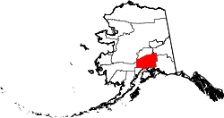
According to the United States Census Bureau, the Petersville CDP has a total area of 462.5 square miles (1,198 km2), of which 461.8 square miles (1,196 km2) are land and 0.7 square miles (1.8 km2), or 0.14%, are water. [1] The CDP is bordered to the west by the Kahiltna River, fed by the Kahiltna Glacier on the south side of Denali.

Climate

Petersville is categorized as being within the 3a USDA hardiness zone, meaning temperatures can get as low as −40 to −35 °F (−40 to −37 °C). [4]

Climate data for Petersville (1,617 feet above sea level)
MonthJanFebMarAprMayJunJulAugSepOctNovDecYear
Mean daily maximum °F (°C)18.0
(−7.8)
22.0
(−5.6)
30.0
(−1.1)
42.0
(5.6)
54.0
(12.2)
65.0
(18.3)
66.0
(18.9)
62.0
(16.7)
52.0
(11.1)
35.0
(1.7)
23.0
(−5.0)
21.0
(−6.1)
40.8
(4.9)
Daily mean °F (°C)11.0
(−11.7)
14.0
(−10.0)
19.5
(−6.9)
30.5
(−0.8)
42.5
(5.8)
53.0
(11.7)
55.5
(13.1)
52.0
(11.1)
42.5
(5.8)
27.5
(−2.5)
16.0
(−8.9)
14.0
(−10.0)
31.5
(−0.3)
Mean daily minimum °F (°C)4.0
(−15.6)
6.0
(−14.4)
9.0
(−12.8)
19.0
(−7.2)
31.0
(−0.6)
41.0
(5.0)
45.0
(7.2)
42.0
(5.6)
33.0
(0.6)
20.0
(−6.7)
9.0
(−12.8)
7.0
(−13.9)
22.2
(−5.5)
Average precipitation inches (mm)2.23
(57)
2.14
(54)
1.43
(36)
1.38
(35)
1.03
(26)
1.65
(42)
3.92
(100)
5.83
(148)
5.82
(148)
3.24
(82)
2.44
(62)
2.91
(74)
34.02
(864)
Source: Weather Channel [5]

Demographics

Historical population
CensusPop.Note
2000 27
2010 4−85.2%
2020 27575.0%
U.S. Decennial Census [6]

Petersville first appeared on the 2000 U.S. Census as a census-designated place (CDP).

As of the census [7] of 2000, there were 27 people, 17 households, and 7 families residing in the CDP. The population density was 0.1 inhabitants per square mile (0.039/km2). There were 189 housing units at an average density of 0.5 per square mile (0.19/km2). The racial makeup of the CDP was 88.89% White, 7.41% Native American and 3.70% Pacific Islander.

There were 17 households, out of which 5.9% had children under the age of 18 living with them, 29.4% were married couples living together, and 58.8% were non-families. 58.8% of all households were made up of individuals, and 11.8% had someone living alone who was 65 years of age or older. The average household size was 1.59 and the average family size was 2.00.

In the CDP, the population was spread out, with 3.7% under the age of 18, 18.5% from 25 to 44, 63.0% from 45 to 64, and 14.8% who were 65 years of age or older. The median age was 52 years. For every 100 females, there were 200.0 males. For every 100 females age 18 and over, there were 225.0 males.

The median income for a household in the CDP was $43,750, and the median income for a family was $0. Males had a median income of $0 versus $0 for females. The per capita income for the CDP was $43,200. There were no families and none of the population living below the poverty line, including no under eighteens and none of those over 64.

See also

Related Research Articles

<span class="mw-page-title-main">Matanuska-Susitna Borough, Alaska</span> Borough in Alaska, United States

Matanuska-Susitna Borough is a borough located in the U.S. state of Alaska. Its borough seat is Palmer, and the largest community is the census-designated place of Knik-Fairview. As of the 2020 census, the borough's population was 107,801.

<span class="mw-page-title-main">Beluga, Alaska</span> Census-designated place in Alaska, United States

Beluga is a census-designated place (CDP) in Kenai Peninsula Borough, Alaska, United States. The population was 20 at the 2010 census, down from 32 in 2000.

<span class="mw-page-title-main">Chase, Alaska</span> CDP in Alaska, United States

Chase is a census-designated place (CDP) in Matanuska-Susitna Borough, Alaska, United States. Located 9.2 miles north from Talkeetna, it is part of the Anchorage, Alaska Metropolitan Statistical Area. The population was 19 at the 2020 census, down from 34 in 2010.

<span class="mw-page-title-main">Chickaloon, Alaska</span> Census-designated place in Matanuska-Susitna Borough, Alaska, United States

Chickaloon is a census-designated place (CDP) in Matanuska-Susitna Borough, Alaska, United States. It is part of the Anchorage, Alaska Metropolitan Statistical Area. The population was 254 at the 2020 census, down from 272 in 2010.

<span class="mw-page-title-main">Fishhook, Alaska</span> CDP in Alaska, United States

Fishhook is a census-designated place (CDP) in Matanuska-Susitna Borough, Alaska, United States. It is part of the Anchorage, Alaska Metropolitan Statistical Area. At the 2020 census the population was 5,048, up from 4,679 in 2010.

<span class="mw-page-title-main">Gateway, Alaska</span> CDP in Alaska, United States

Gateway is a census-designated place (CDP) in Matanuska-Susitna Borough, Alaska, United States. It is part of the Anchorage, Alaska Metropolitan Statistical Area. The population was 5,748 at the 2020 census, up from 5,552 in 2010. Gateway is the fifth-most populated CDP in the borough.

<span class="mw-page-title-main">Glacier View, Alaska</span> Census-designated place in Alaska, United States

Glacier View is a census-designated place (CDP) in Matanuska-Susitna Borough, Alaska, United States. It is part of the Anchorage Metropolitan Area. At the 2020 census the population was 375, up from 234 in 2010. The terminus of Matanuska Glacier is located approximately three miles southwest of Glacier View.

<span class="mw-page-title-main">Lake Louise, Alaska</span> Census-designated place in Alaska, United States

Lake Louise is a census-designated place (CDP) in Matanuska-Susitna Borough, Alaska, United States. Although it is an isolated settlement and is close to Glennallen, it is considered part of the Anchorage Metropolitan Area, like all other locations in the Mat-Su Borough. At the 2020 census the population was 15, down from 46 in 2010 and 88 in 2000.

<span class="mw-page-title-main">Lakes, Alaska</span> CDP in Alaska, United States

Lakes was a census-designated place (CDP) in Matanuska-Susitna Borough, Alaska, United States. It was split in two CDPs for 2020 Census purposes: North Lakes and South Lakes. The area is part of the Anchorage, Alaska Metropolitan Statistical Area. At the 2010 census the population was 8,364, up from 6,706 in 2000.

<span class="mw-page-title-main">Lazy Mountain, Alaska</span> CDP in Alaska, United States

Lazy Mountain is a census-designated place (CDP) in Matanuska-Susitna Borough, Alaska, United States. Located east of Palmer along the Matanuska River. At the 2020 census the population was 1,506, up from 1,479 in 2010.

<span class="mw-page-title-main">Point MacKenzie, Alaska</span> CDP in Alaska, United States

Point MacKenzie is a census-designated place (CDP) in Matanuska-Susitna Borough, Alaska, United States. It is part of the Anchorage, Alaska Metropolitan Statistical Area. At the 2020 census the population was 1,852, up from 529 in 2010.

<span class="mw-page-title-main">Skwentna, Alaska</span> CDP in Alaska, United States

Skwentna is a census-designated place (CDP) on Iditarod Trail in Matanuska-Susitna Borough, Alaska, United States. Located 61 miles northwest of Wasilla along the Skwentna River, it is part of the Anchorage, Alaska Metropolitan Statistical Area. At the 2020 census the population was 62, up from 37 in 2010. The town is served by Skwentna Airport.

<span class="mw-page-title-main">Susitna, Alaska</span> Census-designated place in Alaska, United States

Susitna is a census-designated place (CDP) in Matanuska-Susitna Borough, Alaska, United States. It is part of the Anchorage Metropolitan Area. As of the 2020 census, the population of the CDP was 11.

<span class="mw-page-title-main">Sutton-Alpine, Alaska</span> Census-designated place in Alaska, United States

Sutton is a census-designated place (CDP) in the Matanuska-Susitna Borough in the U.S. state of Alaska. At the 2020 census the population was 1,038, down from 1,447 in 2010. The CDP includes the former coal mining community and road construction camp of Sutton, as well as the former mining camps of Eska and Jonesville.

<span class="mw-page-title-main">Talkeetna, Alaska</span> CDP in Alaska, United States

Talkeetna is a census-designated place (CDP) in Matanuska-Susitna Borough, Alaska, United States. At the 2020 census the population was 1,055, up from 876 in 2010.

<span class="mw-page-title-main">Tanaina, Alaska</span> CDP in Alaska, United States

Tanaina is a census-designated place (CDP) in the Matanuska-Susitna Borough in the U.S. state of Alaska. Located 4 miles north from Wasilla, it is part of the Anchorage, Alaska Metropolitan Statistical Area. At the 2020 census the population was 8,817, up from 8,197 in 2010. Tanaina is the sixth-most populated CDP in Alaska.

<span class="mw-page-title-main">Trapper Creek, Alaska</span> Census-designated place in Alaska, United States

Trapper Creek is a census-designated place (CDP) in Matanuska-Susitna Borough, Alaska, United States. It is part of the Anchorage Metropolitan Area and is known as the southern gateway to Denali State Park. According to the 2020 census the population of Trapper Creek was 499.

<span class="mw-page-title-main">Susitna North, Alaska</span> CDP in Alaska, United States

Susitna North is a census-designated place (CDP) in the Matanuska-Susitna Borough in the U.S. state of Alaska. It is part of the Anchorage, Alaska Metropolitan Statistical Area. The population was 1,564 at the 2020 census, up from 1,260 in 2010. The CDP was formerly named Y, for the intersection of the George Parks Highway and the Talkeetna Spur Road. In the immediate vicinity of this intersection is a community center, containing a health clinic, law enforcement, Susitna Valley High School, and retail services for highway travelers such as gasoline and food.

<span class="mw-page-title-main">Chalkyitsik, Alaska</span> CDP in Alaska, United States

Chalkyitsik, meaning "to fish with a hook, at the mouth of the creek", is a census-designated place (CDP) in Yukon-Koyukuk Census Area, Alaska, United States. It is located on the left (south) bank of the Black River, 45 miles northeast of Fort Yukon. At the 2010 census the population was 69, down from 83 in 2000.

<span class="mw-page-title-main">Anchorage metropolitan area</span> Metropolitan area in the U.S. state of Alaska

The Anchorage Metropolitan Statistical Area, as defined by the United States Census Bureau, is an area consisting of the Municipality of Anchorage and the Matanuska-Susitna Borough in the south central region of Alaska.

References

  1. 1 2 "2021 U.S. Gazetteer Files: Alaska". United States Census Bureau. Retrieved May 4, 2022.
  2. 1 2 "Petersville CDP, Alaska: 2020 DEC Redistricting Data (PL 94-171)". U.S. Census Bureau. Retrieved May 4, 2022.
  3. "US Gazetteer files: 2010, 2000, and 1990". United States Census Bureau. February 12, 2011. Retrieved April 23, 2011.
  4. "USDA Plant Hardiness Zone Map". United States Department of Agriculture. Archived from the original on February 27, 2014. Retrieved August 25, 2018.
  5. "Petersville, AK Monthly Weather Forecast". Weather Channel . Retrieved August 25, 2018.
  6. "U.S. Decennial Census". Census.gov. Retrieved June 6, 2013.
  7. "U.S. Census website". United States Census Bureau . Retrieved January 31, 2008.