Meadow Lakes, Alaska

Last updated

Meadow Lakes, Alaska
CDP
Matanuska-Susitna Borough Alaska incorporated and unincorporated areas Meadow Lakes highlighted.svg
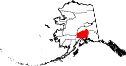
Location in Matanuska-Susitna Borough and the state of Alaska.
USA Alaska location map.svg
Red pog.svg
Meadow Lakes, Alaska
Location within the state of Alaska
Coordinates: 61°35′59″N149°36′58″W / 61.59972°N 149.61611°W / 61.59972; -149.61611
CountryUnited States
State Alaska
Borough Matanuska-Susitna
Government
  Borough mayor Edna DeVries
   State senators Shelley Hughes (R)
Mike Shower (R)
David Wilson (R)
   State reps. David Eastman (R)
Kevin McCabe (R)
Jesse Sumner (R)
Cathy Tilton (R)
Area
[1]
  Total78.64 sq mi (203.67 km2)
  Land75.44 sq mi (195.40 km2)
  Water3.19 sq mi (8.27 km2)
Elevation
377 ft (115 m)
Population
 (2020)
  Total9,197
  Density121.91/sq mi (47.07/km2)
Time zone UTC-9 (Alaska (AKST))
  Summer (DST) UTC-8 (AKDT)
Area code 907
FIPS code 02-47735
GNIS feature ID1866961

Meadow Lakes is a census-designated place (CDP) in Matanuska-Susitna Borough, Alaska, United States. Located west of Wasilla, it is part of the Anchorage, Alaska Metropolitan Statistical Area. As of the 2020 census, the population was 9,197, up from 7,570 in 2010. It is the fifth-most populated CDP in Alaska and the third largest community in the borough. [2]

Contents

Geography

Meadow Lakes is located at 61°35′59″N149°36′58″W / 61.59972°N 149.61611°W / 61.59972; -149.61611 (61.599661, -149.616036). [3]

According to the United States Census Bureau, the CDP has a total area of 70.0 square miles (181 km2), of which, 67.0 square miles (174 km2) of it is land and 3.0 square miles (7.8 km2) of it (4.32%) is water.

Demographics

Historical population
CensusPop.Note
1990 2,374
2000 4,819103.0%
2010 7,57057.1%
2020 9,19721.5%
U.S. Decennial Census [4]

Meadow Lakes first reported on the 1990 U.S. Census as a census-designated place (CDP).

As of the census [5] of 2000, there were 4,819 people, 1,702 households, and 1,215 families residing in the CDP. The population density was 72.0 inhabitants per square mile (27.8/km2). There were 2,003 housing units at an average density of 29.9 per square mile (11.5/km2). The racial makeup of the CDP was 87.9% White, 0.5% Black or African American, 5.4% Native American, 0.6% Asian, 0.2% Pacific Islander, 0.6% from other races, and 4.8% from two or more races. 3.0% of the population were Hispanic or Latino of any race.

There were 1,702 households, out of which 42.5% had children under the age of 18 living with them, 55.1% were married couples living together, 9.2% had a female householder with no husband present, and 28.6% were non-families. 20.9% of all households were made up of individuals, and 3.3% had someone living alone who was 65 years of age or older. The average household size was 2.83 and the average family size was 3.30.

In the CDP, the population was spread out, with 33.4% under the age of 18, 7.1% from 18 to 24, 32.5% from 25 to 44, 22.2% from 45 to 64, and 4.9% who were 65 years of age or older. The median age was 33 years. For every 100 females, there were 113.8 males. For every 100 females age 18 and over, there were 111.5 males.

The median income for a household in the CDP was $41,030, and the median income for a family was $47,534. Males had a median income of $40,948 versus $26,148 for females. The per capita income for the CDP was $17,295. About 12.3% of families and 17.1% of the population were below the poverty line, including 23.7% of those under age 18 and 5.0% of those age 65 or over.

Related Research Articles

<span class="mw-page-title-main">Bear Creek, Alaska</span> Census-designated place in Alaska, United States

Bear Creek is a census-designated place (CDP) in Kenai Peninsula Borough, Alaska, United States. At the 2020 census the population was 2,129 up from 1,956 in 2010. Bear Creek is a few miles north of Seward near the stream of the same name and its source, Bear Lake.

<span class="mw-page-title-main">Crown Point, Alaska</span> Census-designated place in Alaska, United States

Crown Point is a census-designated place (CDP) in Kenai Peninsula Borough, Alaska, United States. The population was 74 at the 2010 census. Land access to this area is by either the Alaska Railroad or the Seward Highway.

<span class="mw-page-title-main">Moose Pass, Alaska</span> Census-designated place in Alaska, United States

Moose Pass is a census-designated place (CDP) in Kenai Peninsula Borough, Alaska, United States. The population was 219 at the 2010 census, up from 206 in 2000.

<span class="mw-page-title-main">Primrose, Alaska</span> Census-designated place in Alaska, United States

Primrose is a census-designated place (CDP) in Kenai Peninsula Borough, Alaska, United States. The population was 78 at the 2010 census, down from 93 at the 2000 census. Primrose is one of a number of small communities located north of Seward along the Seward Highway.

<span class="mw-page-title-main">Big Lake, Alaska</span> CDP in Alaska, United States

Big Lake is a census-designated place (CDP) in Matanuska-Susitna Borough, Alaska, United States. It is part of the Anchorage, Alaska Metropolitan Statistical Area. The population was 3,833 at the 2020 census, up from 3,350 in 2010.

<span class="mw-page-title-main">Buffalo Soapstone, Alaska</span> CDP in Alaska, United States

Buffalo Soapstone is a census-designated place (CDP) in Matanuska-Susitna Borough, Alaska, United States. It is part of the Anchorage, Alaska Metropolitan Statistical Area. The population was 1,021 at the 2020 census, up from 855 in 2010.

<span class="mw-page-title-main">Butte, Alaska</span> CDP in Alaska, United States

Butte is a census-designated place (CDP) in Matanuska-Susitna Borough, Alaska, United States. It is part of the Anchorage, Alaska Metropolitan Statistical Area. At the 2020 census, the population was 3,589, up from 3,246 in 2010. Butte is located between the Matanuska River and the Knik River, approximately 5 miles (8 km) southeast of Palmer. It is accessible via the Old Glenn Highway.

<span class="mw-page-title-main">Farm Loop, Alaska</span> CDP in Alaska, United States

Farm Loop is a census-designated place (CDP) in Matanuska-Susitna Borough, Alaska, United States. It is part of the Anchorage, Alaska Metropolitan Statistical Area. At the 2020 census the population was 2,747, up from 1,028 in 2010.

<span class="mw-page-title-main">Fishhook, Alaska</span> CDP in Alaska, United States

Fishhook is a census-designated place (CDP) in Matanuska-Susitna Borough, Alaska, United States. It is part of the Anchorage, Alaska Metropolitan Statistical Area. At the 2020 census the population was 5,048, up from 4,679 in 2010.

<span class="mw-page-title-main">Gateway, Alaska</span> CDP in Alaska, United States

Gateway is a census-designated place (CDP) in Matanuska-Susitna Borough, Alaska, United States. It is part of the Anchorage, Alaska Metropolitan Statistical Area. The population was 5,748 at the 2020 census, up from 5,552 in 2010. Gateway is the fifth-most populated CDP in the borough.

<span class="mw-page-title-main">Knik-Fairview, Alaska</span> CDP in Alaska, United States

Knik-Fairview is a census-designated place (CDP) in Matanuska-Susitna Borough, Alaska, United States. It is part of the Anchorage, Alaska Metropolitan Statistical Area. At the 2020 census the population was 19,297, up from 14,923 in 2010. It is the most populated CDP in Alaska.

<span class="mw-page-title-main">Lakes, Alaska</span> CDP in Alaska, United States

Lakes was a census-designated place (CDP) in Matanuska-Susitna Borough, Alaska, United States. It was split in two CDPs for 2020 Census purposes: North Lakes and South Lakes. The area is part of the Anchorage, Alaska Metropolitan Statistical Area. At the 2010 census the population was 8,364, up from 6,706 in 2000.

<span class="mw-page-title-main">Point MacKenzie, Alaska</span> CDP in Alaska, United States

Point MacKenzie is a census-designated place (CDP) in Matanuska-Susitna Borough, Alaska, United States. It is part of the Anchorage, Alaska Metropolitan Statistical Area. At the 2020 census the population was 1,852, up from 529 in 2010.

<span class="mw-page-title-main">Sutton-Alpine, Alaska</span> Census-designated place in Alaska, United States

Sutton is a census-designated place (CDP) in the Matanuska-Susitna Borough in the U.S. state of Alaska. At the 2020 census the population was 1,038, down from 1,447 in 2010. The CDP includes the former coal mining community and road construction camp of Sutton, as well as the former mining camps of Eska and Jonesville.

<span class="mw-page-title-main">Tanaina, Alaska</span> CDP in Alaska, United States

Tanaina is a census-designated place (CDP) in the Matanuska-Susitna Borough in the U.S. state of Alaska. Located 4 miles north from Wasilla, it is part of the Anchorage, Alaska Metropolitan Statistical Area. At the 2020 census the population was 8,817, up from 8,197 in 2010. Tanaina is the sixth-most populated CDP in Alaska.

<span class="mw-page-title-main">Willow, Alaska</span> CDP in Alaska, United States

Willow is a census-designated place (CDP) in the Matanuska-Susitna Borough in the U.S. state of Alaska. Located 26 miles northwest from Wasilla along the George Parks Highway, it is part of the Anchorage, Alaska Metropolitan Statistical Area. At the 2020 census the population was 2,196, up from 2,102 in 2010.

Four Mile Road is a census-designated place (CDP) in Yukon-Koyukuk Census Area, Alaska, United States. The population was 43 at the 2010 census, up from 38 in 2000.

<span class="mw-page-title-main">Stevens Village, Alaska</span> CDP in Alaska, United States

Stevens Village is a census-designated place (CDP) in Yukon-Koyukuk Census Area, Alaska, United States. The population was 78 at the 2010 census, down from 87 in 2000.

<span class="mw-page-title-main">White Meadow Lake, New Jersey</span> Populated place in Morris County, New Jersey, US

White Meadow Lake is an unincorporated community and census-designated place (CDP) located within Rockaway Township, in Morris County, in the U.S. state of New Jersey. As of the 2010 United States Census, the CDP's population was 8,836.

<span class="mw-page-title-main">Jarales, New Mexico</span> CDP in New Mexico, United States

Jarales is a census-designated place (CDP) in Valencia County, New Mexico, United States. The population was 2,475 at the 2010 census. It is part of the Albuquerque Metropolitan Statistical Area.

References

  1. "2020 U.S. Gazetteer Files". United States Census Bureau. Retrieved October 29, 2021.
  2. "2020 Census Data - Cities and Census Designated Places" (Web). State of Alaska, Department of Labor and Workforce Development. Retrieved October 31, 2021.
  3. "US Gazetteer files: 2010, 2000, and 1990". United States Census Bureau. February 12, 2011. Retrieved April 23, 2011.
  4. "U.S. Decennial Census". Census.gov. Retrieved June 6, 2013.
  5. "U.S. Census website". United States Census Bureau . Retrieved January 31, 2008.