
Denali is the highest mountain peak in North America, with a summit elevation of 20,310 feet (6,190 m) above sea level. It is the tallest mountain in the world from base-to-peak on land, measuring 18,000 ft (5,500 m), With a topographic prominence of 20,194 feet (6,155 m) and a topographic isolation of 4,621.1 miles (7,436.9 km), Denali is the third most prominent and third-most isolated peak on Earth, after Mount Everest and Aconcagua. Located in the Alaska Range in the interior of the U.S. state of Alaska, Denali is the centerpiece of Denali National Park and Preserve.

Denali National Park and Preserve, formerly known as Mount McKinley National Park, is a United States national park and preserve located in Interior Alaska, centered on Denali, the highest mountain in North America. The park and contiguous preserve encompass 6,045,153 acres which is larger than the state of New Hampshire. On December 2, 1980, 2,146,580-acre Denali Wilderness was established within the park. Denali's landscape is a mix of forest at the lowest elevations, including deciduous taiga, with tundra at middle elevations, and glaciers, snow, and bare rock at the highest elevations. The longest glacier is the Kahiltna Glacier. Wintertime activities include dog sledding, cross-country skiing, and snowmobiling. The park received 594,660 recreational visitors in 2018.

Wrangell–St. Elias National Park and Preserve is a United States national park and preserve in south central Alaska. The park, the largest in the United States, covers the Wrangell Mountains and a large portion of the Saint Elias Mountains, which include most of the highest peaks in the United States and Canada, yet are within 10 miles (16 km) of tidewater, one of the highest reliefs in the world. The park's high point is Mount Saint Elias at 18,008 feet (5,489 m), the second tallest mountain in both the United States and Canada. The park has been shaped by the competing forces of volcanism and glaciation, with its tall mountains uplifted by plate tectonics. Mount Wrangell and Mount Churchill are among major volcanos in these ranges. The park's glacial features include Malaspina Glacier, the largest piedmont glacier in North America, Hubbard Glacier, the longest tidewater glacier in Alaska, and Nabesna Glacier, the world's longest valley glacier. The Bagley Icefield covers much of the park's interior, which includes 60% of the permanently ice-covered terrain in Alaska. At the center of the park and preserve, the boomtown of Kennecott exploited one of the world's richest deposits of copper from 1903 to 1938. The abandoned mine buildings and mills comprise a National Historic Landmark district.

Glacier Bay Basin in southeastern Alaska, in the United States, encompasses the Glacier Bay and surrounding mountains and glaciers, which was first proclaimed a U.S. National Monument on February 25, 1925, and which was later, on December 2, 1980, enlarged and designated as the Glacier Bay National Park and Preserve under the Alaska National Interest Lands Conservation Act, covering an area of 3,283,000 acres. In 1986, UNESCO declared an area of 57,000 acres within a World Biosphere Reserve. This is the largest UNESCO protected biosphere in the world. In 1992, UNESCO included this area as a part of a World Heritage site, extending over an area of 24,300,000-acre (98,000 km2) which also included the Wrangell-St. Elias National Park, Kluane National Park (Canada) and Tatshenshini-Alsek Park (Canada). Part of the National Park is also designated a Wilderness area covering 2,658,000 acres.

Mount Blackburn is the highest peak in the Wrangell Mountains of Alaska in the United States. It is the fifth-highest peak in the United States and the twelfth-highest peak in North America. The mountain is an old, eroded shield volcano, the second-highest volcano in the U.S. behind Mount Bona and the fifth-highest in North America. It was named in 1885 by Lt. Henry T. Allen of the U.S. Army after Joseph Clay Stiles Blackburn, a U.S. senator from Kentucky. It is located in the heart of Wrangell – St. Elias National Park, the largest national park in the country.

Mount Sanford is a shield volcano in the Wrangell Volcanic Field, in eastern Alaska near the Copper River. It is the sixth highest mountain in the United States and the third highest volcano behind Mount Bona and Mount Blackburn. The south face of the volcano, at the head of the Sanford Glacier, rises 8,000 feet (2,400 m) in 1 mile (1,600 m) resulting in one of the steepest gradients in North America.
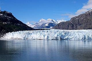
Margerie Glacier is a 21 mi (34 km) long tidewater glacier in Glacier Bay, Alaska, United States within the boundaries of Glacier Bay National Park and Preserve. The glacier begins on the southern slopes of Mount Root, elevation 12,860 feet (3,920 m), on the Alaska–Canada border flowing southeast down the valley, then turning to the northeast toward its terminus in Tarr Inlet. Margerie Glacier is one of the most active and frequently-visited glaciers in Glacier Bay, which was declared a National Monument in 1925, a National Park and Preserve in 1980, a UNESCO World Biosphere Reserve in 1986 and a World Heritage Site in 1992. While most of the tidewater glaciers in the park have been receding over the last several decades, Margerie Glacier has become stable, neither growing nor receding, while Johns Hopkins Glacier is advancing.

Mount Bona is one of the major mountains of the Saint Elias Mountains in eastern Alaska, and is the fifth-highest independent peak in the United States. It is either the tenth- or eleventh-highest peak in North America. Mount Bona and its adjacent neighbor Mount Churchill are both large ice-covered stratovolcanoes. Bona has the distinction of being the highest volcano in the United States and the fourth-highest in North America, outranked only by the three highest Mexican volcanoes, Pico de Orizaba, Popocatépetl, and Iztaccíhuatl. Its summit is a small stratovolcano on top of a high platform of sedimentary rocks.
Mount Jarvis is an eroded shield volcano and stratovolcano in the Wrangell Mountains of eastern Alaska. It is located in Wrangell-Saint Elias National Park about 10 miles (16 km) east of the summit of Mount Wrangell. The mountain sits at the northeastern edge of the massive ice-covered shield of Wrangell, rising nearly 5,000 feet (1,500 m) above it in a spectacular series of cliffs and icefalls.

Talkeetna Air Taxi, established in 1947 as Talkeetna Air Service, is a Talkeetna, Alaska-based flight company. It operates wheel-ski equipped bush planes, and is one of less than a half-dozen air services with a permit to land in Denali National Park. Historically, business included supply runs to remote homesteads and prospecting claims—though in the past decade traffic has been primarily tourist and climber related.

Mount Church is a 7,621-foot (2,323 m) mountain in the Alaska Range, in Denali National Park and Preserve, overlooking Ruth Glacier. It is situated on the west side of the Ruth Gorge and 0.87 mi (1 km) southeast of Mount Grosvenor, which is the nearest higher neighbor. The mountain was named by famed explorer Dr. Frederick Cook who claimed the first ascent of Mount McKinley in 1906, but was later disproved.

Mount Johnson is an 8,400+ ft mountain summit located in the Alaska Range, in Denali National Park and Preserve, in Alaska, United States. It is situated on the west side of the Ruth Gorge, 15 miles (24 km) southeast of Denali and six miles (9.7 km) south-southwest of The Moose's Tooth. The nearest higher neighbor is Mount Wake, 0.69 miles (1.11 km) to the northwest.

Mount Bradley is a 9,100+ ft mountain summit located in the Alaska Range, in Denali National Park and Preserve, in Alaska, United States. It is situated on the west side of the Ruth Gorge, 13.33 mi (21 km) southeast of Denali and 4.68 mi (8 km) southwest of The Moose's Tooth. Its nearest higher peak is Mount Dickey, 1.41 miles (2.27 km) to the north, Mount Wake lies 1.51 miles (2.43 km) to the south, and London Tower rises 2.55 miles (4.10 km) directly east on the opposite side of The Great Gorge. Despite its relatively low elevation, it is notable for its north face with nearly 5,000 feet of vertical sheer granite. The mountain was named by famed explorer Dr. Frederick Cook for John R. Bradley, a wealthy casino owner from Florida and one of Cook's financial sponsors.

Mount Wake is a 9,100+ ft mountain summit located in the Alaska Range, in Denali National Park and Preserve, in Alaska, United States. It is situated on the west side of the Ruth Gorge, 14.44 mi (23 km) southeast of Denali and 5.85 mi (9 km) southwest of The Moose's Tooth. The nearest higher neighbor is Mount Dickey, 2.92 miles (4.70 km) to the north. Mount Bradley lies 1.51 miles (2.43 km) to the north, and Mount Johnson lies 0.89 miles (1.43 km) to the southeast. Despite its relatively low elevation, it is notable for its north face with over 4,000 feet of vertical sheer granite. The mountain was named by famed explorer Dr. Frederick Cook for his friend Charles Wake.

London Tower is a 7,550 ft (2,300 m) mountain summit located in the Alaska Range, in Denali National Park and Preserve, in Alaska, United States. It is situated on the east side of the Ruth Gorge, 15.23 mi (25 km) southeast of Denali and 3.38 mi (5 km) south of The Moose's Tooth. Mount Bradley rises 2.55 miles (4.10 km) directly across The Great Gorge to the west. Despite its relatively low elevation, it is notable for its west face with over 3,000 feet of vertical granite.

Tokosha Mountains is a 6,148 ft (1,870 m) multi-peak massif located in the Alaska Range, in Denali National Park and Preserve, in Alaska, United States. It is situated between the toes of Ruth Glacier and Tokositna Glacier, 27 mi (43 km) south-southeast of Denali and 26 mi (42 km) northwest of Talkeetna. Despite its relatively low elevation, it is notable for its Teton-esque granite spires which can be seen from the George Parks Highway. Precipitation runoff from the mountain drains into the Tokositna River → Chulitna River → Susitna River. Topographic relief is significant as the highest summit, Grand Tokosha, rises 3,850 feet above the Ruth Glacier in one mile (1.6 km).

Mount Kudlich is an 11,301 ft (3,440 m) mountain summit located in the Alaska Range, in Denali National Park and Preserve, in Alaska, United States. Mount Kudlich is also referred to as Peak 11,300. It is situated 4,000 feet above the confluence of the West and Northwest Forks of Ruth Glacier, on the west side of the Don Sheldon Amphitheater, 6.15 mi (10 km) southeast of Denali, 2.5 mi (4 km) north of Mount Huntington, and 3 mi (5 km) west-southwest of Mount Dan Beard. The mountain was possibly named by explorer Belmore Browne for Herman C. Kudlich (1861-1946), City Magistrate of New York and member of the American Museum of Natural History. Belmore Browne participated in Frederick Cook's 1906 expedition which claimed the first ascent of Mount McKinley, but was later disproved.

Mount Barrille is a 7,650 ft (2,330 m) mountain summit located in the Alaska Range, in Denali National Park and Preserve, in the U.S. state of Alaska. It is situated 2,650 feet above the Ruth Glacier at the gateway to the Don Sheldon Amphitheater, or The Great Gorge, depending on direction of travel. Barrille is set 11.43 mi (18 km) southeast of Denali, 3.37 mi (5 km) west of The Mooses Tooth, 3.68 mi (6 km) east of The Rooster Comb, and 1.42 mi (2 km) north of Mount Dickey which is the nearest higher peak. The mountain was named by famed explorer Dr. Frederick Cook for Edward Barrill (1861–1946), a horse packer from Darby, Montana, who was his sole companion during his 1906 claim to be the first to climb Denali. The claim was later disproved, and in 1909 Barrill signed an affidavit stating that they had not reached the summit. Cook referred to his companion as Barrille in his accounts of the expedition, and Barrille remains as the official spelling used by the United States Geological Survey.

Mount Grosvenor is an 8,400+ ft mountain summit located in the Alaska Range, in Denali National Park and Preserve, in Alaska, United States. It is situated on the west side of the Ruth Gorge, 0.87 mi (1 km) northwest of Mount Church and 0.54 mi (1 km) south of Mt. Johnson. Its nearest higher peak is Mount Wake, 1.32 miles (2.12 km) to the northwest. Despite its relatively low elevation, it is notable for its east face with over 4,000 feet of vertical sheer granite. The mountain was named by famed explorer Dr. Frederick Cook who claimed the first ascent of Mount McKinley in 1906, but was later disproved. This peak's unofficial name honors Gilbert Hovey Grosvenor (1875–1966), President of the National Geographic Society, father of photojournalism, and the first full-time editor of National Geographic magazine. The first ascent of the peak was made in 1979 by Gary Bocarde, Charlie Head, John Lee, and Jon Thomas.


