Kenai Peninsula Borough, Alaska

Last updated

Kenai Peninsula Borough
Overhead view of Homer and Kachemak Bay.jpg
Sunrise on Kachemak Bay.jpg
Kenai River Alaska.jpg
Coral Seymour Memorial Ballpark.jpg
Mount Alice seen from Mount Marathon.jpg
Turnagain Arm and Kenai Mountains (1).jpg
Left to right, from top: Overhead view of Homer and Kachemak Bay, sunrise on Kachemak Bay, view of Kenai Lake, the Coral Seymour Memorial Ballpark, view of Mount Alice at Seward, view of the Kenai Mountains
Kenai Peninsula Borough, Alaska seal.png
Map of Alaska highlighting Kenai Peninsula Borough.svg
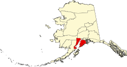
Location within the U.S. state of Alaska
Alaska in United States (US50).svg
Alaska's location within the U.S.
Coordinates: 60°25′00″N151°15′00″W / 60.416666666667°N 151.25°W / 60.416666666667; -151.25
CountryFlag of the United States.svg United States
StateFlag of Alaska.svg  Alaska
Incorporated January 1, 1964 [1] [2]
Named for Kenai Peninsula
Seat Soldotna
Largest city Kalifornsky
Area
  Total
24,752 sq mi (64,110 km2)
  Land16,075 sq mi (41,630 km2)
  Water8,677 sq mi (22,470 km2)  35.1%
Population
 (2020)
  Total
58,799
  Estimate 
(2023)
61,223 Increase2.svg
  Density2.4/sq mi (0.92/km2)
Time zone UTC−9 (Alaska)
  Summer (DST) UTC−8 (ADT)
Congressional district At-large
Website www.kpb.us

Kenai Peninsula Borough is a borough of the U.S. state of Alaska. As of the 2020 census, the population was 58,799, up from 55,400 in 2010. [3] The borough seat is Soldotna, [4] the largest city is Kenai, and the most populated community is the census-designated place of Kalifornsky.

Contents

The borough includes most of the Kenai Peninsula and a large area of the mainland of Alaska on the opposite side of Cook Inlet.

Geography

View of Seldovia, located along Kachemak Bay Seldovia.jpg
View of Seldovia, located along Kachemak Bay

The borough has a total area of 24,752 square miles (64,110 km2), of which 16,075 square miles (41,630 km2) is land and 8,677 square miles (22,470 km2) (3.4%) is water. [5]

Adjacent boroughs and census areas

National protected areas

Ecology

Bear Lake, Tutka Bay, and the Trail Lakes, have been the site of salmon enhancement activities. All three sites are managed by the Cook Inlet Aquaculture Association [6] Some of the fish hatched at these facilities are released into the famous Homer fishing hole. Cook Inlet Keeper and the Cook Inlet Regional Citizen's Advisory Council are groups that attempt to influence public policy on the use of the area's resources.

Demographics

Historical population
CensusPop.Note
1960 6,097
1970 14,250133.7%
1980 25,28277.4%
1990 40,80261.4%
2000 49,69121.8%
2010 55,40011.5%
2020 58,7996.1%
2023 (est.)61,223 [7] 4.1%
U.S. Decennial Census [8]
1790-1960 [9] 1900-1990 [10]
1990-2000 [11] 2010-2020 [3]

2020 census

As of the census of 2020, there were 58,799 people.

2000 census

As of the census of 2000, there were 49,700 people, 18,400 households, and 12,700 families residing in the borough. The population density was 1 people/km2 (2.6 people/sq mi). There were 24,900 housing units at an average density of 2 units per square mile (0.77 units/km2). The racial makeup of the borough was 86% white, 7% Native American, 2% Hispanic or Latino (any race), and 4% from two or more races. Black or African Americans, Asians, and Pacific Islanders each were less than 1%. [12] Just under 1% were from other races combined. 1.92% reported speaking Russian at home, while 1.74% spoke Spanish. [13]

Of the 18,400 households, 38% had children under the age of 18 living with them, 55% were married couples living together, 9% had a female householder with no husband present, and 31% were non-families. 25% of households were one person, and 5% were one person aged 65 or older. The average household size was 2.6 and the average family size was 3.2.

In the borough the population was spread out, with 30% under the age of 18, 7% from 18 to 24, 30% from 25 to 44, 26% from 45 to 64, and 7% 65 or older. The median age was 36 years. For every 100 females, there were 109 males; for every 100 females age 18 and over there were 110 males.

Government and infrastructure

There is a borough-wide government based in Soldotna, consisting of a strong mayor and an assembly of representatives from all areas of the borough. They collect sales and property taxes and provide services such as road maintenance, waste collection facilities, emergency services and major funding for public schools, along with mitigation of damage from spruce bark beetles that infested the borough in the late 1990s and early 2000s. [14] Incorporated towns also have their own local governments and city councils. The Alaska Department of Corrections operates the Spring Creek Correctional Center near Seward [15] [16] and the Wildwood Correctional Complex near Kenai.

Kenai Peninsula is one of the most Republican boroughs in the state, having last backed a Democrat for president in 1968.

United States presidential election results for Kenai Peninsula Borough, Alaska [17]
Year Republican Democratic Third party(ies)
No.%No.%No.%
2024 21,86165.50%10,34731.00%1,1683.50%
2020 21,76164.10%10,96532.30%1,2223.60%
2016 18,40867.02%7,57827.59%1,4815.39%
2012 17,15767.35%7,72130.31%5982.35%
2008 18,94967.30%8,36229.70%8453.00%
2004 10,47867.93%4,64830.13%2991.94%
2000 15,05366.81%4,63320.56%2,84612.63%
1996 10,60658.13%5,17728.37%2,46213.49%
1992 6,90237.50%4,82826.23%6,67636.27%
1988 8,63361.05%4,71833.37%7895.58%
1984 10,29770.38%3,68725.20%6464.42%
1980 7,02060.78%2,17818.86%2,35220.36%
1976 4,69760.32%2,52832.46%5627.22%
1972 3,21457.45%1,52027.17%86015.37%
1968 2,04439.35%2,16941.76%98118.89%
1964 1,26535.49%2,29964.51%00.00%
1960 1,57347.29%1,75352.71%00.00%

Communities

The George A. Navarre Building on Binkley Street in downtown Soldotna serves as the administrative headquarters for the borough and its school district. Navarre moved to Kenai in 1957, owned and operated a variety of Kenai-based businesses, and was the borough's mayor from 1966 to 1972. His son, Mike Navarre, was mayor from 1996 to 1999 and 2011 to 2017. Kenai Peninsula Borough Building.jpg
The George A. Navarre Building on Binkley Street in downtown Soldotna serves as the administrative headquarters for the borough and its school district. Navarre moved to Kenai in 1957, owned and operated a variety of Kenai-based businesses, and was the borough's mayor from 1966 to 1972. His son, Mike Navarre, was mayor from 1996 to 1999 and 2011 to 2017.

Cities

Census-designated places

Unincorporated communities

Ghost town

Education

The school district for the whole borough is Kenai Peninsula Borough School District. [18]

See also

References

  1. "Kenai Peninsula Borough, Resolution No. 1: Legal Status - Borough and Borough School District" (PDF). Kenai Peninsula Borough. January 4, 1964. Archived (PDF) from the original on October 9, 2022. Retrieved May 3, 2012.
  2. 1996 Alaska Municipal Officials Directory. Juneau: Alaska Municipal League/Alaska Department of Community and Regional Affairs. January 1996. p. 8.
  3. 1 2 "State & County QuickFacts". United States Census Bureau. Retrieved April 15, 2023.
  4. "Kenai Peninsula Borough Profile". National Association of Counties. Retrieved November 3, 2021.
  5. "US Gazetteer files: 2010, 2000, and 1990". United States Census Bureau. February 12, 2011. Retrieved April 23, 2011.
  6. "Project Bear Lake". Archived from the original on September 7, 2007. Retrieved February 3, 2007.
  7. "Annual Estimates of the Resident Population for Counties: April 1, 2020 to July 1, 2023". United States Census Bureau. Retrieved March 28, 2024.
  8. "U.S. Decennial Census". United States Census Bureau. Retrieved May 18, 2014.
  9. "Historical Census Browser". University of Virginia Library. Retrieved May 18, 2014.
  10. "Population of Counties by Decennial Census: 1900 to 1990". United States Census Bureau. Retrieved May 18, 2014.
  11. "Census 2000 PHC-T-4. Ranking Tables for Counties: 1990 and 2000" (PDF). United States Census Bureau. Archived (PDF) from the original on October 9, 2022. Retrieved May 18, 2014.
  12. "U.S. Census website". United States Census Bureau . Retrieved May 14, 2011.
  13. "Language Map Data Center". Mla.org. July 17, 2007. Retrieved December 20, 2012.
  14. "Kenai Peninsula Borough Government official site". Borough.kenai.ak.us. Retrieved December 20, 2012.
  15. "City of Seward 2020 Comprehensive Plan Volume II Archived June 8, 2011, at the Wayback Machine ." City of Seward. 94/97. Retrieved on August 15, 2010.
  16. "Spring Creek Correctional Center Archived August 26, 2010, at the Wayback Machine ." Alaska Department of Corrections. Retrieved on August 15, 2010.
  17. Elections, RRH. "RRH Elections". rrhelections.com. Retrieved January 12, 2020.
  18. "2020 CENSUS - SCHOOL DISTRICT REFERENCE MAP: Kenai Peninsula Borough, AK" (PDF). United States Census Bureau. Archived (PDF) from the original on October 9, 2022. Retrieved July 27, 2022. - Text list

60°25′N151°15′W / 60.417°N 151.250°W / 60.417; -151.250