Kenai Peninsula Borough is a borough of the U.S. state of Alaska. As of the 2020 census, the population was 58,799, up from 55,400 in 2010. The borough seat is Soldotna, the largest city is Kenai, and the most populated community is the census-designated place of Kalifornsky.

Bear Creek is a census-designated place (CDP) in Kenai Peninsula Borough, Alaska, United States. At the 2020 census the population was 2,129 up from 1,956 in 2010. Bear Creek is a few miles north of Seward near the stream of the same name and its source, Bear Lake.

Soldotna is a city in the Kenai Peninsula Borough in the U.S. state of Alaska. At the 2020 census, the population was 4,342, up from 4,163 in 2010. It is the seat of the Kenai Peninsula Borough.

The Kenai Peninsula is a large peninsula jutting from the coast of Southcentral Alaska. The name Kenai is derived from the word "Kenaitze" or "Kenaitze Indian Tribe", the name of the Native Athabascan Alaskan tribe, the Kahtnuht’ana Dena’ina, who historically inhabited the area. They called the Kenai Peninsula Yaghanen.

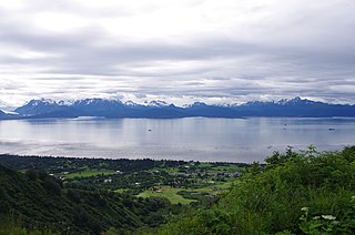
Cook Inlet stretches 180 miles (290 km) from the Gulf of Alaska to Anchorage in south-central Alaska. Cook Inlet branches into the Knik Arm and Turnagain Arm at its northern end, almost surrounding Anchorage. On its southern end, it merges with Shelikof Strait, Stevenson Entrance, Kennedy Entrance and Chugach Passage.
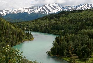
The Kenai River called Kahtnu in the Dena'ina language, is the longest river in the Kenai Peninsula of southcentral Alaska. It runs 82 miles (132 km) westward from Kenai Lake in the Kenai Mountains, through the Kenai National Wildlife Refuge and Skilak Lake to its outlet into the Cook Inlet of the Pacific Ocean near Kenai and Soldotna.

The Sterling Highway is a 138-mile-long (222 km) state highway in the south-central region of the U.S. state of Alaska, leading from the Seward Highway at Tern Lake Junction, 90 miles (140 km) south of Anchorage, to Homer.
The Swanson River (Dena'ina: Yaghetnu) is a stream, 40 miles (64 km) long, on the Kenai Peninsula of south-central Alaska in the United States. Beginning at Gene Lake in the Swanson Lakes district, it flows southwest then north to Number Three Bay on the Gompertz Channel of Cook Inlet.

The Kasilof River or Ggasilatnu in the Dena'ina language is a river on the western Kenai Peninsula in southern Alaska. The name is an anglicization of Reka Kasilova, the name given to the river by early Russian settlers in the area. It begins at Tustumena Lake and flows northwest to Cook Inlet near Kasilof. The upper section of the river is very swift, with several sections considered Class II whitewater, and underwater hazards are difficult to detect, due to the silty nature of the glacial runoff that comprises most of the river. The entire river has powerful currents and is very cold. There is public access to the lower section from the Sterling Highway. Drift and bank fishing for salmon is popular on the lower Kasilof.
The Chugach National Forest is a 6,908,540-acre (27,958 km2) United States National Forest in south central Alaska. Covering portions of Prince William Sound, the Kenai Peninsula and the Copper River Delta, it was formed in 1907 from part of a larger forest reserve. The Chugach includes extensive shorelines, glaciers, forests and rivers, much of which is untouched by roads or trails. It hosts numerous bird, mammal and marine species, including extensive shorebird habitat and a bald eagle population larger than the contiguous 48 states combined. Human industry in the forest includes extensive tourism and some mining and oil and gas operations.

Southwest Alaska is a region of the U.S. state of Alaska. The area is not exactly defined by any governmental administrative region(s); nor does it always have a clear geographic boundary.

The Kenai National Wildlife Refuge is a 1.92-million-acre (7,770 km2) wildlife habitat preserve located on the Kenai Peninsula of Alaska, United States. It is adjacent to Kenai Fjords National Park. This refuge was created in 1941 as the Kenai National Moose Range, but in 1980 it was changed to its present status by the Alaska National Interest Lands Conservation Act. The refuge is administered from offices in Soldotna.

Kenai Lake is a large, "zig-zag" shaped lake on the Kenai Peninsula, Alaska. The lake forms the headwaters of the Kenai River, and is itself a destination for fishing and other outdoor activity. The Dena'ina call the lake Sqilan Bena, meaning "ridge lake place". Due to its size and shape it is accessible from both the Sterling Highway and the Seward Highway.

The Trail Lakes are two lakes on the lower Kenai Peninsula, Alaska. The lakes are near the town of Moose Pass and adjacent to the Seward Highway. They are the home of a large salmon hatchery owned by the state of Alaska and operated by the Cook Inlet Aquaculture Association. The fish hatched at this facility are released into streams and lakes at various points on the peninsula, and are also the source of the salmon runs at the "fishing hole" on the Homer Spit. The hatchery was at the center of a prolonged legal battle between the Wilderness Society and the U.S. Fish and Wildlife Service. The society claimed that the hatchery was conducting commercial activity in a wilderness area, and such activity is illegal under the Wilderness Act.

The Cook Inlet Aquaculture Association (CIAA) is a non-profit organization based in Kenai, Alaska, that works to create sustainable salmon stocks in the Cook Inlet area.
The Chuitna Coal Project was a proposed coal strip mine that, if granted state and federal permits, would have been built about 45 miles (72 km) southwest of Anchorage, Alaska, in an area known as the Beluga Coal Fields near the Chuitna River and the small communities of Tyonek and Beluga in upper Cook Inlet.
The Southern Southeast Regional Aquaculture Association or SSRAA for short, is a non-profit company located out of Alaska. Their mission is "to enhance and rehabilitate salmon production in southern Southeast Alaska to the optimum social and economic benefit of salmon users". They have a total of four salmon hatcheries that grow salmon to age and then release then into the wild.

Captain Cook State Recreation Area is a park on the Kenai Peninsula in Alaska. It is located on the shores of Cook Inlet at the northern terminus of the Kenai Spur Highway, about 25 miles (40 km) north of Kenai and 14 miles (23 km) north of Nikiski. Both the Inlet and the recreation area are named after Captain James Cook who explored the area in 1778.
The Resurrection River is a large river on the Kenai Peninsula in Alaska. It rises near Upper Russian Lake in the Kenai Mountains and flows 22 miles (35 km) to empty into Resurrection Bay near Seward. Part of the river passes through Kenai Fjords National Park. There has been small-scale placer mining for gold at the confluence of the river and Placer Creek.
Humpy Cove is an inlet of Resurrection Bay on the Kenai Peninsula of the U.S. state of Alaska. Located 11 miles from Seward, it has the shape of a whale's tail, and consists of two smaller bays. The cove is often used as an anchorage for recreational boaters. It received its name from the plentiful returns of pink salmon that spawn in Humpy Creek, the inflow of the southern bay. The cove is a popular tourist destination as well, due to Orca Island Cabins and kayak tours offered by Miller's Landing. Humpy Cove has runs of rockfish, halibut, coho salmon, chinook salmon, and chum salmon as well as pinks, and a popular fishing spot is near the Iron Door, the remains of a searchlight and bunker from World War II. The cove contains the only road on the Resurrection Peninsula, a stretch of pavement leading to the aforementioned searchlight.


