Primrose, Alaska

Last updated

Primrose, Alaska
Primroseak.JPG
Primrose waterfront seen from Chugach National Forest campground
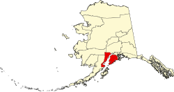
AKMap-doton-Primrose.PNG
Location of Primrose, Alaska
Coordinates: 60°20′36″N149°20′39″W / 60.34333°N 149.34417°W / 60.34333; -149.34417
CountryUnited States
State Alaska
Borough Kenai Peninsula
Government
  Borough mayor Peter Micciche
   State senator Jesse Bjorkman (R)
   State rep. Ben Carpenter (R)
Area
[1]
  Total35.50 sq mi (91.96 km2)
  Land34.47 sq mi (89.27 km2)
  Water1.03 sq mi (2.68 km2)
Elevation
3,212 ft (979 m)
Population
 (2020)
  Total96
  Density2.79/sq mi (1.08/km2)
Time zone UTC-9 (Alaska (AKST))
  Summer (DST) UTC-8 (AKDT)
Area code 907
FIPS code 02-64240
GNIS feature ID2419191

Primrose is a census-designated place (CDP) in Kenai Peninsula Borough, Alaska, United States. The population was 78 at the 2010 census, [2] down from 93 at the 2000 census. Primrose is one of a number of small communities located north of Seward along the Seward Highway.

Contents

Geography

Primrose is located on the eastern part of the Kenai Peninsula at 60°20′36″N149°20′39″W / 60.34333°N 149.34417°W / 60.34333; -149.34417 (60.343405, -149.344250), [3] at the mouth of the Snow River in Kenai Lake. It is bordered to the north by Crown Point and to the south by Bear Creek. Alaska Route 9, the Seward Highway, runs through the community, leading south 18 miles (29 km) to Seward and north the same distance to Alaska Route 1 at Tern Lake.

According to the United States Census Bureau, the Primrose CDP has a total area of 38.2 square miles (99.0 km2), of which 34.5 square miles (89.3 km2) are land and 1.0 square mile (2.7 km2), or 2.92%, are water. [2]

Demographics

Historical population
CensusPop.Note
1990 63
2000 9347.6%
2010 78−16.1%
2020 9623.1%
U.S. Decennial Census [4]

Primrose first appeared on the 1990 U.S. Census as a census-designated place (CDP).

As of the 2000 census, [5] there were 93 people, 33 households, and 29 families residing in the CDP. The population density was 2.5 inhabitants per square mile (0.97/km2). There were 47 housing units at an average density of 1.3 per square mile (0.50/km2). The racial makeup of the CDP was 91.40% White, 3.23% Native American, 1.08% Asian, 1.08% Pacific Islander, and 3.23% from two or more races.

There were 33 households, out of which 42.4% had children under the age of 18 living with them, 75.8% were married couples living together, 6.1% had a female householder with no husband present, and 12.1% were non-families. 9.1% of all households were made up of individuals, and none had someone living alone who was 65 years of age or older. The average household size was 2.82 and the average family size was 3.00.

In the CDP, the population was spread out, with 34.4% under the age of 18, 1.1% from 18 to 24, 24.7% from 25 to 44, 28.0% from 45 to 64, and 11.8% who were 65 years of age or older. The median age was 42 years. For every 100 females, there were 93.8 males. For every 100 females age 18 and over, there were 96.8 males.

The median income for a household in the CDP was $66,111, and the median income for a family was $66,944. Males had a median income of $48,472 versus $0 for females. The per capita income for the CDP was $18,904. None of the population and none of the families were below the poverty line.

Related Research Articles

<span class="mw-page-title-main">Anchor Point, Alaska</span> Census-designated place in Alaska, United States

Anchor Point is an unincorporated community and census-designated place (CDP) in Kenai Peninsula Borough, in the U.S. state of Alaska. As of the 2010 census the population was 1,930, up from 1,845 in 2000. The community is located along the Sterling Highway, part of Alaska State Route 1. Anchor Point is the westernmost point in the North American highway system.

<span class="mw-page-title-main">Bear Creek, Alaska</span> Census-designated place in Alaska, United States

Bear Creek is a census-designated place (CDP) in Kenai Peninsula Borough, Alaska, United States. At the 2020 census the population was 2,129 up from 1,956 in 2010. Bear Creek is a few miles north of Seward near the stream of the same name and its source, Bear Lake.

<span class="mw-page-title-main">Beluga, Alaska</span> Census-designated place in Alaska, United States

Beluga is a census-designated place (CDP) in Kenai Peninsula Borough, Alaska, United States. The population was 20 at the 2010 census, down from 32 in 2000.

<span class="mw-page-title-main">Clam Gulch, Alaska</span> Census-designated place in Alaska, United States

Clam Gulch is a census-designated place (CDP) in Kenai Peninsula Borough, Alaska, United States. At the 2020 census, the population was 207.

<span class="mw-page-title-main">Cohoe, Alaska</span> Census-designated place in Alaska, United States

Cohoe (Dena'ina: Qughuhnaz’ut) is a census-designated place (CDP) in Kenai Peninsula Borough, Alaska, United States. At the 2010 census the population was 1,364, up from 1,168 in 2000.

<span class="mw-page-title-main">Cooper Landing, Alaska</span> Census-designated place in Alaska, United States

Cooper Landing is a census-designated place (CDP) in Kenai Peninsula Borough, Alaska, United States, about 100 miles (160 km) south of Anchorage, at the outlet of Kenai Lake into the Kenai River. The town was first settled in the 19th century by gold and mineral prospectors, and has become a popular summer tourist destination thanks to its scenic location and proximity to the salmon fishery of the Kenai River and Russian River. As of the 2010 census, the population in Cooper Landing was 289, down from 369 in 2000.

<span class="mw-page-title-main">Crown Point, Alaska</span> Census-designated place in Alaska, United States

Crown Point is a census-designated place (CDP) in Kenai Peninsula Borough, Alaska, United States. The population was 74 at the 2010 census. Land access to this area is by either the Alaska Railroad or the Seward Highway.

<span class="mw-page-title-main">Funny River, Alaska</span> Census-designated place in Alaska, United States

Funny River is a census-designated place (CDP) in Kenai Peninsula Borough, Alaska, United States. At the 2010 census the population was 877, up from 636 in 2000.

<span class="mw-page-title-main">Hope, Alaska</span> Census-designated place in Alaska, United States

Hope is a census-designated place (CDP) in Kenai Peninsula Borough in the U.S. state of Alaska. It is eighty-seven miles south from Anchorage. As of the 2010 census the population was 192, up from 137 in 2000.

<span class="mw-page-title-main">Kalifornsky, Alaska</span> Census-designated place in Alaska, United States

Kalifornsky is a census-designated place (CDP) in Kenai Peninsula Borough, Alaska, United States. The population was 8,487 at the 2020 census, up from 7,850 in 2010. It is the most populated locality in the borough.

<span class="mw-page-title-main">Kasilof, Alaska</span> Census-designated place in Alaska, United States

Kasilof is a census-designated place (CDP) in Kenai Peninsula Borough, Alaska, United States. At the 2020 census the population was 525, down from 549 in 2010.

<span class="mw-page-title-main">Lowell Point, Alaska</span> Census-designated place in Alaska, United States

Lowell Point is a census-designated place (CDP) in Kenai Peninsula Borough, Alaska, United States, just outside Seward. At the 2010 census the population was 80, down from 92 in 2000.

<span class="mw-page-title-main">Moose Pass, Alaska</span> Census-designated place in Alaska, United States

Moose Pass is a census-designated place (CDP) in Kenai Peninsula Borough, Alaska, United States. The population was 219 at the 2010 census, up from 206 in 2000.

<span class="mw-page-title-main">Nikiski, Alaska</span> Census-designated place in Alaska, United States

Nikiski is a census-designated place (CDP) in Kenai Peninsula Borough, Alaska, United States. The population was 4,456 at the 2020 census, down from 4,493 in 2010.

Ridgeway is a census-designated place (CDP) in Kenai Peninsula Borough, Alaska, United States. At the 2020 census the population was 2,136, up from 2,022 in 2010.

Salamatof is a census-designated place (CDP) in Kenai Peninsula Borough, Alaska, United States. The population was 1,078 at the 2020 census, up from 980 in 2010. Salamatof is the location for the former Wildwood Air Force Station, which operated from 1965 to 1972. Today, it is the Wildwood Correctional Complex.

<span class="mw-page-title-main">Sterling, Alaska</span> Census-designated place in Alaska, United States

Sterling is a census-designated place (CDP) in Kenai Peninsula Borough, Alaska, United States. At the 2020 census the population was 5,918, up from 5,617 in 2010. Sterling is the tenth-most populated CDP in Alaska.

<span class="mw-page-title-main">Sunrise, Alaska</span> Archaeological site in Alaska, United States

Sunrise is a census-designated place (CDP) in Kenai Peninsula Borough, Alaska, United States. The population was 18 at the 2010 census, unchanged from 2000.

<span class="mw-page-title-main">Point MacKenzie, Alaska</span> CDP in Alaska, United States

Point MacKenzie is a census-designated place (CDP) in Matanuska-Susitna Borough, Alaska, United States. It is part of the Anchorage, Alaska Metropolitan Statistical Area. At the 2020 census the population was 1,852, up from 529 in 2010.

<span class="mw-page-title-main">Sebastian, Texas</span> CDP in Texas, United States

Sebastian is a census-designated place (CDP) in Willacy County, Texas, United States. The population was 1,917 at the 2010 census.

References

  1. "2020 U.S. Gazetteer Files". United States Census Bureau. Retrieved October 29, 2021.
  2. 1 2 "Geographic Identifiers: 2010 Demographic Profile Data (G001): Primrose CDP, Alaska". U.S. Census Bureau, American Factfinder. Retrieved January 23, 2019.[ dead link ]
  3. "US Gazetteer files: 2010, 2000, and 1990". United States Census Bureau. February 12, 2011. Retrieved April 23, 2011.
  4. "Census of Population and Housing". Census.gov. Retrieved June 4, 2016.
  5. "U.S. Census website". United States Census Bureau . Retrieved January 31, 2008.