
Soldotna is a city in the Kenai Peninsula Borough in the U.S. state of Alaska. At the 2020 census, the population was 4,342, up from 4,163 in 2010. It is the seat of the Kenai Peninsula Borough.
Sterling is a census-designated place (CDP) in Kenai Peninsula Borough, Alaska, United States. At the 2020 census the population was 5,918, up from 5,617 in 2010. Sterling is the tenth-most populated CDP in Alaska.

Lake Louise is a census-designated place (CDP) in Matanuska-Susitna Borough, Alaska, United States. Although it is an isolated settlement and is close to Glennallen, it is considered part of the Anchorage Metropolitan Area, like all other locations in the Mat-Su Borough. At the 2020 census the population was 15, down from 46 in 2010 and 88 in 2000.

The Kenai Peninsula is a large peninsula jutting from the coast of Southcentral Alaska. The name Kenai is derived from the word "Kenaitze" or "Kenaitze Indian Tribe", the name of the Native Athabascan Alaskan tribe, the Kahtnuht’ana Dena’ina, who historically inhabited the area. They called the Kenai Peninsula Yaghanen.
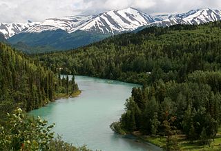
The Kenai River called Kahtnu in the Dena'ina language, is the longest river in the Kenai Peninsula of southcentral Alaska. It runs 82 miles (132 km) westward from Kenai Lake in the Kenai Mountains, through the Kenai National Wildlife Refuge and Skilak Lake to its outlet into the Cook Inlet of the Pacific Ocean near Kenai and Soldotna.

The Russian River is a 13-mile-long (21 km) river on the Kenai Peninsula in the U.S. state of Alaska. It flows northward from Upper Russian Lake in the Kenai Mountains through Lower Russian Lake, draining into the Kenai River near the town of Cooper Landing. The native Denaina people called this river Chunuk'tnu.

The Sterling Highway is a 138-mile-long (222 km) state highway in the south-central region of the U.S. state of Alaska, leading from the Seward Highway at Tern Lake Junction, 90 miles (140 km) south of Anchorage, to Homer.
The Seward Highway is a highway in the U.S. state of Alaska that extends 125 miles (201 km) from Seward to Anchorage. It was completed in 1951 and runs through the scenic Kenai Peninsula, Chugach National Forest, Turnagain Arm, and Kenai Mountains. The Seward Highway is numbered Alaska Route 9 (AK-9) for the first 37 miles (60 km) from Seward to the Sterling Highway and AK-1 for the remaining distance to Anchorage. At the junction with the Sterling Highway, AK-1 turns west towards Sterling and Homer. About eight miles (13 km) of the Seward Highway leading into Anchorage is built to freeway standards. In Anchorage, the Seward Highway terminates at an intersection with 5th Avenue, which AK-1 is routed to, and which then leads to the Glenn Highway freeway.
The Swanson River (Dena'ina: Yaghetnu) is a stream, 40 miles (64 km) long, on the Kenai Peninsula of south-central Alaska in the United States. Beginning at Gene Lake in the Swanson Lakes district, it flows southwest then north to Number Three Bay on the Gompertz Channel of Cook Inlet.

Tustumena Lake is a lake on the west side of the Kenai Peninsula in southcentral Alaska, within Kenai National Wildlife Refuge and near the town of Kasilof. Access is only via the Kasilof River, as there are no roads that lead directly to the lake.

Wood-Tikchik State Park is a state park in the U.S. state of Alaska north of Dillingham. Over 1,600,000 acres (650,000 ha) (6,500 km2) in area—about the size of the state of Delaware—, comprising more than half of all state park land in Alaska and 15% of the total state park land in the country. Despite being the largest state park in the nation, the park had no staff whatsoever for its first five years, and even now at times only a single ranger is in charge of patrolling the entire park, usually by aircraft.

The Kenai National Wildlife Refuge is a 1.92-million-acre (7,770 km2) wildlife habitat preserve located on the Kenai Peninsula of Alaska, United States. It is adjacent to Kenai Fjords National Park. This refuge was created in 1941 as the Kenai National Moose Range, but in 1980 it was changed to its present status by the Alaska National Interest Lands Conservation Act. The refuge is administered from offices in Soldotna. The Kenai Wilderness protects 1,354,247 acres of the refuge as wilderness area.

The Andrew Berg Cabin near Soldotna, Alaska was built by fisherman and trapper Andrew Berg in 1902. It was listed on the National Register of Historic Places in 2000.

The Summer Lake Wildlife Area is a 29.6-square-mile (77 km2) wildlife refuge located on the northwestern edge of the Great Basin drainage in south-central Oregon. It is administered by the Oregon Department of Fish and Wildlife. The refuge is an important stop for waterfowl traveling along the Pacific Flyway during their spring and fall migrations. The Summer Lake Wildlife Area also provides habitat for shorebirds and other bird species as well as wide variety of mammals and several fish species. The Ana River supplies the water for the refuge wetlands.

The Funny River Fire or the Funny River Horse Trail Fire was a forest fire that began on May 19, 2014 near Soldotna, Alaska. It quickly grew to over 20,000 acres, and by May 23 it had burned over 67,000 acres or about 105 square miles. Tustumena Lake acted as a natural barrier keeping the fire from spreading south. A July 10 overflight found no sign of the fire continuing to burn. It had grown to 195,858 acres.

Summit Lake is located on Canyon Creek in the Chugach National Forest, Alaska, United States and is situated along the Seward Highway (AK-1) 10 miles (16 km) north-northeast of Moose Pass and about 23 miles (37 km) southwest of the Portage area of Anchorage. The lake is fed by Canyon Creek from the southwest and Tenderfoot Creek from the east. The lake empties into Canyon Creek on the northeast, which flows through Lower Summit Lake, into Six Mile Creek, and eventually into the Turnagain Arm of the Cook Inlet.

Stormy Lake is a lake on the Kenai Peninsula of Alaska, also known as Three Bay Lake. It is located 27 miles (43 km) north of the town of Kenai. The lake has been the target of two efforts to eradicate invasive species and re-introduce native flora and fish.

Nancy Lake State Recreation Area is a 22,685 acres (9,180 ha) park near Willow in the Matanuska-Susitna Borough of Alaska. Founded on July 6, 1966, and set aside specifically for recreational use, the park is home to more than a hundred lakes as well as extensive wetlands. The landscape of the park was crafted in glacial retreats around 9,000 years ago, and around this same time the first inhabitants likely moved into the area. They were eventually followed by Russian exploration, and later increases in white settlement due to commerce and the presence of gold.

The Swan Lake Fire was a large lightning-caused wildfire that burnt between Sterling and Cooper Landing on the Kenai Peninsula in Alaska from June 5, 2019, until the autumn of that year. In total, the fire burned approximately 170,000 acres.

Hidden Lake is a lake on the Kenai Peninsula of Alaska, formed by an ancient channel of the Kenai River. It is located entirely inside the Kenai National Wildlife Refuge. The lake is deepest at its southeast end, with depths up to 148 feet (45 m). The back country section of the lake in the northwest has several islands and depths in the range of 10–70 feet (3.0–21.3 m). Being in the foothills of the Kenai Mountains, much of the shoreline is very steep, and wooded with birch and spruce trees. The only outflow from the lake is Hidden Creek, a short, shallow creek that flows into the Kenai River just North of Skilak Lake.


