
Kenai Peninsula Borough is a borough of the U.S. state of Alaska. As of the 2010 census, the population was 55,400. The borough seat is Soldotna.
The Kenai Peninsula is a large peninsula jutting from the coast of Southcentral Alaska. The name Kenai is derived from the word "Kenaitze" or "Kenaitze Indian Tribe", the name of the Native Athabascan Alaskan tribe, the Kahtnuht’ana Dena’ina, who historically inhabited the area. They called the Kenai Peninsula Yaghanen.
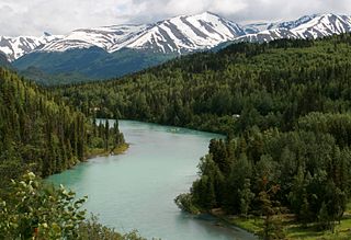
The Kenai River called Kahtnu in the Dena'ina language and Кенай in Russian, is the longest river in the Kenai Peninsula of south central Alaska. It runs 82 miles (132 km) westward from Kenai Lake in the Kenai Mountains, through the Kenai National Wildlife Refuge and Skilak Lake to its outlet into the Cook Inlet of the Pacific Ocean near Kenai and Soldotna.

The Swanson River is a stream, 40 miles (64 km) long, on the Kenai Peninsula of south-central Alaska in the United States. Beginning at Gene Lake in the Swanson Lakes district, it flows southwest then north to Number Three Bay on the Gompertz Channel of Cook Inlet.

Iliamna Lake or Lake Iliamna is a lake in southwest Alaska, at the north end of the Alaska Peninsula, between Kvichak Bay and Cook Inlet, about 100 miles (160 km) west of Seldovia, Alaska.

The Kvichak River is a large river, about 50 miles (80 km) long, in southwestern Alaska in the United States. It flows southwest from Lake Iliamna to Kvichak Bay, an arm of Bristol Bay, on the Alaska Peninsula. The communities of Igiugig and Levelock lie along the Kvichak River. The Kvichak is navigable along its entire length, and is used as a short cut by boats getting between Cook Inlet and Bristol Bay via the Lake Iliamna portage.

The Kasilof River or Ggasilatnu in the Dena'ina language is a river on the western Kenai Peninsula in southern Alaska. The name is an anglicization of Reka Kasilova, the name given to the river by early Russian settlers in the area. It begins at Tustumena Lake and flows northwest to Cook Inlet near Kasilof. The upper section of the river is very swift, with several sections considered Class II whitewater, and underwater hazards are difficult to detect, due to the silty nature of the glacial runoff that comprises most of the river. The entire river has powerful currents and is very cold. There is public access to the lower section from the Sterling Highway. Drift and bank fishing for salmon is popular on the lower Kasilof.

The Egegik River is a waterway in the U.S. state of Alaska. A biological survey was conducted at the base of the Alaska Peninsula in 1902 by Wilfred Hudson Osgood, which included the Egegik River.

The Mount Massive Wilderness is a federally designated wilderness area in the Sawatch Range, located in the U.S. state of Colorado. It is operated jointly by the United States Forest Service and the Fish and Wildlife Service as part of the San Isabel National Forest and the Leadville National Fish Hatchery. It is 30,540 acres (123.6 km2) in size, with 27,980 acres (113.2 km2) in San Isabel National Forest and 2,560 acres (10.4 km2) in Leadville National Fish Hatchery, and it was designated by the US Congress in 1980. The name comes from Mount Massive, the second highest peak in Colorado, located inside the wilderness. Elevations in the wilderness range from 9,700 feet (3,000 m) to 14,421 feet (4,396 m). It is the only federally designated wilderness area within the National Fish Hatchery System.

The Kenai National Wildlife Refuge is a 1.92-million-acre (7,770 km2) wildlife habitat preserve located on the Kenai Peninsula of Alaska, United States. It is adjacent to Kenai Fjords National Park. This refuge was created in 1941 as the Kenai National Moose Range, but in 1980 it was changed to its present status by the Alaska National Interest Lands Conservation Act. The refuge is administered from offices in Soldotna.

Bear Lake is near the town of Seward and Resurrection Bay, in the Kenai Peninsula Borough on the Kenai Peninsula in the U.S. state of Alaska. It is accessible from Bear Creek Road, which connects it to the Seward Highway. It is the site of salmon enhancement activities since 1962. This program is now managed by the Cook Inlet Aquaculture Association. Current projects at Bear Lake focus on increasing sockeye and coho salmon by controlling species that are predators and competitors.

The Homer Spit is a geographical landmark located in Homer, Alaska on the southern tip of the Kenai Peninsula. The spit is a 4.5-mile (7.2 km) long piece of land jutting out into Kachemak Bay. The spit is also home to the Homer Boat Harbor. The harbor contains both deep and shallow water docks and serves up to 1500 commercial and pleasure boats at its summer peak. Additional features and attractions include The Nick Dudiak Fishing Lagoon, which is an artificial "fishing hole", campgrounds, hotels, and restaurants and the Salty Dawg Saloon, which is constructed out of several historic buildings from Homer. Hundreds of eagles formerly gathered there in winter to be fed by Jean Keene, the "Eagle Lady". The Spit features the longest road into ocean waters in the entire world, taking up 10–15 minutes to cover by car.
The Anchor River is a stream on the Kenai Peninsula in the U.S. state of Alaska. Beginning near Bald Mountain on the eastern side of the lower peninsula, if flows generally west for 30 miles (48 km) into Cook Inlet near Anchor Point on the western side of the peninsula. The river mouth is 14 miles (23 km) northwest of Homer.

The Cook Inlet Aquaculture Association or CIAA is a non-profit organization based in Kenai, Alaska that works to create sustainable salmon stocks in the Cook Inlet area.
Aquaculture in Alaska is dominated by the production of shellfish and aquatic plants. These include Pacific oysters, blue mussels, littleneck clams, scallops, and bull kelp. Finfish farming has been prohibited in Alaska by the 16.40.210 Alaskan statute, however non-profit mariculture continues to provide a steady supply of aquaculture in the state. Many organizations that helped the ban, now encourage the growing of shellfish and other oysters.
The Southern Southeast Regional Aquaculture Association or SSRAA for short, is a non-profit company located out of Alaska. Their mission is "to enhance and rehabilitate salmon production in southern Southeast Alaska to the optimum social and economic benefit of salmon users". They have a total of four salmon hatcheries that grow salmon to age and then release then into the wild.

Chester Creek is one of several streams that flow through the city of Anchorage, Alaska. It runs for 21 miles (34 km) from the Chugach Mountains to the Knik Arm of Cook Inlet.

Captain Cook State Recreation Area is a park on the Kenai Peninsula in Alaska. It is located on the shores of Cook Inlet at the northern terminus of the Kenai Spur Highway, about 25 miles (40 km) north of Kenai and 14 miles (23 km) north of Nikiski. Both the Inlet and the recreation area are named after Captain James Cook who explored the area in 1778.

The Westchester Lagoon is a combination of two artificial lakes which form a coastal lagoon near Downtown Anchorage, Alaska. On the lagoons western end, a raised, earthen levee offers right of way for the Alaska Railroad. The levee separates the lagoon from Cook Inlet's Knik Arm, although a large culvert allows spawning salmon swimming upstream from Cook Inlet to use the Chester Creek outflow they will find there. The Tony Knowles Coastal Trail system passes this end of the lagoon, before turning east and passing the Bootleggers Cove neighborhood to the north of the lagoon and continuing further inland into Anchorage. The lagoons eastern boundary is Spenard Road. To the south are single and multi-family homes, Hillcrest Drive and West Anchorage High School. The lagoon is bisected by Minnesota Drive, forming two distinct lakes.

Stormy Lake is a lake on the Kenai Peninsula of Alaska, also known as Three Bay Lake. It is located 27 miles (43 km) north of the town of Kenai. The lake has been the target of two efforts to eradicate invasive species and re-introduce native flora and fish.


