Eek, Alaska

Last updated

Eek
Ekvicuaq
Eek, AK from a bush plane.jpg
Eek, Alaska, from a bush plane
USA Alaska location map.svg
Red pog.svg
Eek
Location in Alaska
Coordinates: 60°13′7″N162°1′33″W / 60.21861°N 162.02583°W / 60.21861; -162.02583
CountryFlag of the United States.svg  United States
State Flag of Alaska.svg  Alaska
Census Area Bethel
Incorporated July 9, 1970 [1]
Government
   Mayor Carlie Beebe [2]
   State senator Lyman Hoffman (D) [3]
   State rep. Conrad McCormick (D)
Area
[4]
  Total0.74 sq mi (1.92 km2)
  Land0.65 sq mi (1.68 km2)
  Water0.09 sq mi (0.24 km2)
Elevation
3 ft (1 m)
Population
 (2020)
  Total404
  Density623.46/sq mi (240.83/km2)
Time zone UTC-9 (Alaska (AKST))
  Summer (DST) UTC-8 (AKDT)
ZIP codes
99578
Area code 907
FIPS code 02-21040
GNIS feature ID 1401666

Eek (Central Yupik : Iik) is a city in Bethel Census Area, Alaska, United States. As of the 2020 census there were 404 residents, [5] the majority being Alaska Natives.

Contents

Toponymy

Eek is derived from a Yupik word meaning "two eyes". [6] It has been noted on lists of unusual place names. [7]

Geography

Eek is located at 60°13′7″N162°1′33″W / 60.21861°N 162.02583°W / 60.21861; -162.02583 (60.218662, -162.025928). [8] It lies along the Eek River. [9]

According to the United States Census Bureau, the city has a total area of 1.0-square-mile (2.6 km2), of which 0.9-square-mile (2.3 km2) is land and 0.1-square-mile (0.26 km2) (12.38%) is water. [10]

Services

Eek is serviced primarily by the Eek Airport. A second (former) airport east of the village is the current site of a cellular transmission tower, but the runway remains in marginally usable condition and is occasionally used by private aircraft. A town dock provides access to the Eek River, which feeds into the Kuskokwim providing access to most surrounding villages by boat. During winter months many residents utilize travel by snow machine and trails are laid out between the villages in the area. Trails from Eek run to Quinhagak to the south, Tuntutuliak to the west and the Bethel area to the north.

Airfare to the nearest large town, Bethel, is expensive, running about $250 in 2020. This severely limits medical care and governmental access. [11]

Houses in Eek are not numbered, which makes gaining identification difficult for residents. [11]

Education

Lower Kuskokwim School District operates the Eek School, a bilingual PreK-12 school. As of 2018 it has 120 students and six teachers. [12] [13] The Principal is Troy Poage and the school board President is Clarence Daniel. About $21,000 is spent per pupil. [12] In 2020 the state awarded $34.4 million to create a new school in Eek to reduce severe classroom overcrowding, a result of a quickly growing population. It is expected to be finished in 2022. [14]

Two teachers at the Eek School, Paul and Eloise Forrer, compiled a large collection of photos of Eek and surrounding villages, as well as a film entitled The Children of Eek and their art. Their work, dating mostly from the 1970s to 1990s, is held at the Anchorage Museum. [15]

Demographics

Historical population
CensusPop.Note
1920 119
1930 100−16.0%
1940 17070.0%
1950 141−17.1%
1960 20041.8%
1970 186−7.0%
1980 22822.6%
1990 25411.4%
2000 28010.2%
2010 2965.7%
2020 40436.5%
U.S. Decennial Census [16]

Eek Village was originally located on the Apokak River and moved to its present location in the late 1920s, after flooding and erosion caused the people to relocate. [17] In 1900 Census, the village was known as "Apokagamiut" and had 118 residents. by 1910, the number of residents declined to 68. Eek appeared on the 1920 U.S. Census as an unincorporated village. In the 1930 Census, the village was enumerated in the Alaska Territory Fourth Judicial District, Bethel District, 0015. with 100 residents in 18 households. [10] It received a post office in 1949. [17] It was formally incorporated in 1970.[ citation needed ]

As of the census of 2000, there were 280 people, 76 households, and 57 families residing in the city. The population density was 307.2 inhabitants per square mile (118.6/km2). There were 83 housing units at an average density of 91.1 per square mile (35.2/km2). The racial makeup of the city was 3.21% White, 95.71% Alaska Native/Yupik, and 1.07% from two or more races. 0.36% of the population were Hispanic or Latino of any race. [10]

There were 76 households, out of which 43.4% had children under the age of 18 living with them, 50.0% were married couples living together, 19.7% had a female householder with no husband present, and 25.0% were non-families. 25.0% of all households were made up of individuals, and 5.3% had someone living alone who was 65 years of age or older. The average household size was 3.68 and the average family size was 4.54. [10]

In the city, the age distribution of the population shows 41.1% under the age of 18, 10.4% from 18 to 24, 27.9% from 25 to 44, 14.3% from 45 to 64, and 6.4% who were 65 years of age or older. The median age was 24 years. For every 100 females, there were 120.5 males. For every 100 females age 18 and over, there were 117.1 males. [10]

The median income for a household in the city was $17,500, and the median income for a family was $27,500. The per capita income for the city was $8,957. About 32.7% of families and 28.8% of the population were below the poverty line, including 30.5% of those under the age of 18 and 10.0% of those 65 or over. [10] In 2020, more than three-quarters of the students at the Eek School were below the poverty line. [12]

In 2019 there were 474 residents. [18] 98% were Yup'ik Natives, 1% were white and 1% were Hispanic. [19]

Economy

Most households rely on traditional native subsistence. [19]

Infrastructure

Prior to 2019, the city did not have running water. Water was distributed by truck to households, at a cost of 25 cents per five gallons. In light of health concerns over the lack of running water, the Alaska Native Tribal Health Consortium helped the city by providing a grant for piped running water, which was completed in 2019. [18]

The city has only one non-satellite internet provider, General Communication Inc. [20]

Related Research Articles

<span class="mw-page-title-main">Bethel Census Area, Alaska</span> Census area in Alaska, United States

Bethel Census Area is a census area in the U.S. state of Alaska. As of the 2020 census, the population is 18,666, up from 17,013 in 2010. It is part of the unorganized borough and therefore has no borough seat. Its largest community is the city of Bethel, which is also the largest city in the unorganized borough.

<span class="mw-page-title-main">Akiachak, Alaska</span> Census-designated place in Alaska, United States

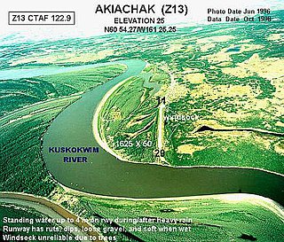
Akiachak is a census-designated place (CDP) in the Bethel Census Area in the U.S. state of Alaska. The population was 677 in the 2020 census, up from 627 in 2010, and 585 in 2000.

<span class="mw-page-title-main">Akiak, Alaska</span> City in Alaska, United States

Akiak(ACK-ee-ack) is a city in Bethel Census Area, Alaska, United States. The population was 462 at the 2020 census, up from 346 in 2010. It is the home of the Akiak Native Community.

<span class="mw-page-title-main">Aniak, Alaska</span> City in Alaska, United States

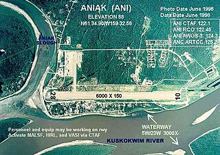
Aniak is a city in the Bethel Census Area in the U.S. state of Alaska. At the 2010 census the population was 501, down from 572 in 2000.

<span class="mw-page-title-main">Atmautluak, Alaska</span> CDP in Alaska, United States

Atmautluak is a census-designated place (CDP) in Bethel Census Area, Alaska, United States. The population was 277 at the 2010 census, down from 294 in 2000.

<span class="mw-page-title-main">Bethel, Alaska</span> City in Alaska, United States

Bethel is a city in the U.S. state of Alaska, located on the Kuskokwim River approximately 50 miles (80 km) from where the river discharges into Kuskokwim Bay. It is the largest community in western Alaska and in the Unorganized Borough and the eighth-largest in the state. Bethel has a population of 6,325 as of the 2020 census, up from 6,080 in 2010.

<span class="mw-page-title-main">Chefornak, Alaska</span> City in Alaska, United States

Chefornak is a city in Bethel Census Area, Alaska, United States. At the 2010 census its population was 418, up from 394 in 2000.

<span class="mw-page-title-main">Chuathbaluk, Alaska</span> City in Alaska, United States

Chuathbaluk is a city in Bethel Census Area, Alaska, United States.

<span class="mw-page-title-main">Goodnews Bay, Alaska</span> City in Alaska, United States

Goodnews Bay is a city in Bethel Census Area, Alaska, United States. As of the 2010 census, the population of the city was 243, up from 230 in 2000.

<span class="mw-page-title-main">Kasigluk, Alaska</span> Census-designated place in Alaska, United States

Kasigluk is a census-designated place (CDP) in the Bethel Census Area in the U.S. state of Alaska. At the 2010 census the population was 569, up from 543 in 2000. Kasigluk consists of two smaller villages, called Akiuk and Akula.

<span class="mw-page-title-main">Kwethluk, Alaska</span> City in Alaska, United States

Kwethluk is a city in Bethel Census Area in the U.S. state of Alaska. At the 2010 census the population was 721, up from 713 in 2000. It is the birthplace of Saint Olga of Alaska

<span class="mw-page-title-main">Napakiak, Alaska</span> City in Alaska, United States

Napakiak is a city in Bethel Census Area, Alaska, United States. At the 2010 census the population was 354, up one resident from 353 since 2000.

<span class="mw-page-title-main">Napaskiak, Alaska</span> City in Alaska, United States

Napaskiak is a city in Bethel Census Area, Alaska, United States. At the 2010 census the population was 405, up from 390 in 2000.

Nightmute is a city and village in Bethel Census Area, Alaska, United States. The population was 208 at the 2000 census and 280 as of the 2010 census.

Nunapitchuk is a city in Bethel Census Area, Alaska, United States. At the 2010 census the population was 496, up from 466 in 2000.

<span class="mw-page-title-main">Quinhagak, Alaska</span> City in Alaska, United States

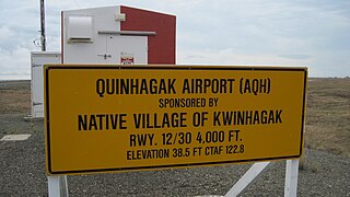
Quinhagak is a city in Bethel Census Area, Alaska, United States. As of the 2020 census, the population of the city is 776, up from 669 in 2010.

<span class="mw-page-title-main">Tuntutuliak, Alaska</span> CDP in Alaska, United States

Tuntutuliak is a census-designated place (CDP) in Bethel Census Area, Alaska, United States. At the 2010 census the population was 408, up from 370 in 2000.

<span class="mw-page-title-main">Tununak, Alaska</span> CDP in Alaska, United States

Tununak(Too-new-nak) is a census-designated place (CDP) in Bethel Census Area, Alaska, United States. At the 2020 census, the population was 411.
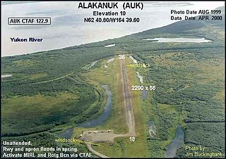
Kotlik is a city in Kusilvak Census Area, Alaska, United States. At the 2010 census the population was 577, down from 591 in 2000.

<span class="mw-page-title-main">Russian Mission, Alaska</span> City in Alaska, United States

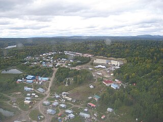
Russian Mission is a city in Kusilvak Census Area, Alaska. It was the location of a fur trading post of the Russian-American Company in 1842. After the sale of Russian-American possessions to the United States in 1867, it was officially named Russian Mission in the early 1900s. The sale of alcohol is prohibited. At the 2020 census the population was 421, up from 312 in 2010.

References

  1. "Directory of Borough and City Officials 1974". Alaska Local Government. XIII (2). Juneau: Alaska Department of Community and Regional Affairs: 31. January 1974.
  2. 2015 Alaska Municipal Officials Directory. Juneau: Alaska Municipal League. 2015. p. 56.
  3. "Senator Lyman Hoffman". Alaska Senate Majority. Alaskasenate.org. Archived from the original on April 8, 2020. Retrieved November 16, 2019.
  4. "2020 U.S. Gazetteer Files". United States Census Bureau. Retrieved October 29, 2021.
  5. "2020 Census Data - Cities and Census Designated Places" (Web). State of Alaska, Department of Labor and Workforce Development. Retrieved October 31, 2021.
  6. Bright, William (2004). Native American Placenames of the United States. University of Oklahoma Press. p. 141. ISBN   978-0-8061-3598-4.
  7. Parker, Quentin (2010). Welcome to Horneytown, North Carolina, Population: 15: An insider's guide to 201 of the world's weirdest and wildest places. Adams Media. pp. ix. ISBN   9781440507397.[ permanent dead link ]
  8. "US Gazetteer files: 2010, 2000, and 1990". United States Census Bureau. February 12, 2011. Retrieved April 23, 2011.
  9. Alaska Atlas & Gazetteer (7th ed.). Yarmouth, Maine: DeLorme. 2010. pp. 55, 130–31. ISBN   978-0-89933-289-5.
  10. 1 2 3 4 5 6 "U.S. Census website". United States Census Bureau . Retrieved January 31, 2008.
  11. 1 2 "Eek traditional council approves funds to bring DMV to town to issue Real IDs". Anchorage Daily News. January 7, 2020. Retrieved October 18, 2020.
  12. 1 2 3 "Eek School Profile". education.alaska.gov. Retrieved October 18, 2020.
  13. "Eek School." Eek School. Retrieved on July 13, 2018.
  14. "Overcrowded Alaska village schools take priority over erosion-threatened schools in state funding, superintendent says". Anchorage Daily News. February 19, 2020. Retrieved October 18, 2020.
  15. Paul and Eloise Forrer Collection, 1966-2009 Reference code: AkAMH. Anchorage Museum at Rasmuson Center. Bob and Evangeline Atwood Alaska Resource Center
  16. "Census of Population and Housing". Census.gov. Retrieved June 4, 2015.
  17. 1 2 "The History of Eek - ExploreNorth". www.explorenorth.com. Retrieved October 18, 2020.
  18. 1 2 "Tiny Alaska community of Eek gets running water for 1st time". KINY. Retrieved October 18, 2020.
  19. 1 2 "Eek School: About". eek.lksd.org. Retrieved October 18, 2020.
  20. "Internet Providers in Eek, AK & Cable/TV Companies". DecisionData. Retrieved October 18, 2020.

60°13′07″N162°01′33″W / 60.218662°N 162.025928°W / 60.218662; -162.025928