Crow Village, Alaska

Last updated

Crow Village
USA Alaska location map.svg
Red pog.svg
Crow Village
Location within the state of Alaska
Coordinates: 61°34′15″N159°47′00″W / 61.57083°N 159.78333°W / 61.57083; -159.78333
Country United States
State Alaska
Census area Bethel
Government
   State senator Lyman Hoffman (D)
   State rep. Zach Fansler (D)
Time zone UTC-9 (Alaska (AKST))
  Summer (DST) UTC-8 (AKDT)
GNIS feature ID1894033 [1]

Crow Village is an unincorporated community on the Kuskokwim River in the U.S. state of Alaska. There are an estimated six residents.[ citation needed ]

Contents

Geography

Crow Village is located in the Bethel Census Area on the north bank of the Kuskokwim River 6.5 miles (10.5 km) by river west of Aniak, just downstream from where the Crow Village Slough flows back into the Kuskokwim River. Crow Village is 86 miles (138 km) northeast of Bethel.

Demographics

Historical population
CensusPop.Note
1880 59
1890 17−71.2%
U.S. Decennial Census [2]

Old Crow Village first appeared on the 1880 U.S. Census as the unincorporated Inuit village of "Toolooka-anahamute" (AKA Tuluka). [3] All 59 residents were listed as Inuit. [4] It returned on the 1890 census as "Tulukagnagamiut." It featured 17 residents, all Native. [5] It did not report on the census again. The original village is referred to today as "Old Crow Village", located 1/2 mile east of the present "new" village. Crow Village is, as of 2010, not a part of any census-designated place or Alaska Native Village Statistical Area (ANVSA), so does not have an official population count. Unverified estimates have stated it to have 5 or 6 residents.

History

Crow Village Sam circa 1970 CrowVillageSam adjusted.jpg
Crow Village Sam circa 1970

Crow Village was originally called Tulukarugmiut (Tulukaghogamiut) by the native Yup'ik population, which roughly translates as "Raven Village People". [6] It is widely believed to be named that after the boisterous raven population native to the nearby bluff. It has also been called Tulukagnag, Toolooka-anahamute, Tuluka and Tulukagangamiut by various explorers and historians; however it is now referred to as Crow Village.

Evidence shows that Kuskokwim Yup'ik ( Kuskowagamiut ) [7] began migrating inland from the Bering Sea up the Kuskokwim and Yukon Rivers around 500 years ago. The first recorded history of Crow Village was in 1843 by Lt. Lavrenty Zagoskin who was dispatched by the Russian Navy to conduct reconnaissance in the Alaska Interior for potential forts and trading posts. He traveled to the Kuskokwim River traveling by boat to Bristol Bay, then portaging across several rivers and entering the Kuskokwim through the headwaters of the Hoholitna. He described the village at that time as one of the two main villages on the Kuskokwim with a year-round population of approximately 100. This village moved up and down the bank with changes in the river's course and appeared in the 1880 census which was the first census accounting for Alaska population following the Alaska Purchase in 1867. That census was completed by Ivan Petrof [8] and listed Crow Village as Toolooka-anahamute with a population of 59.

Around 1910, Crow Village was moved about 0.5 mile (800 m) downstream due to a change in the river sediment pattern. This settlement was also referred to as New Crow Village. Crow Village Sam (Phillips), a future leader of the area's native people, was a youngster at that time and participated in that move. By the 1950s, Crow Village Sam was firmly entrenched as the area's leader. In 1954 he decided the village had to be vacated to stem ongoing issues with epidemics, possibly from lack of knowledge that the epidemics were likely caused by increased contact with white settlers and not directly related to the village itself. He moved the inhabitants upriver 18 miles (29 km) to Chuathbaluk, a village that had been abandoned since 1929.

Archaeology

Given the length of occupancy of Crow Village by the native population, the site has had several archaeological digs. Archaeologist Aleš Hrdlička recovered some bone material from Old Crow Village in 1930 and reportedly took some pictures. [9] In 1953, archaeologist Wendell H. Oswalt collected tree ring samples at New Crow Village. He would return for a three-week study in 1954 with James Van Stone and again in 1963 for the entire summer. The 1963 dig was the most extensive as they researched 5 dwellings in Old Crow Village and interviewed area natives including Crow Village Sam as part of their research into the cultural history of the area. The findings can be found in the book entitled "The Ethnoarchaeology of Crow Village, Alaska". [10] This project pioneered the use of archaeology as a means to augment oral and written sources in constructing a historical ethnography of a Native people.

The Alaska Native Claims Settlement Act of 1971 resulted in Crow Village Sam receiving ownership of the land encompassing Crow Village. This claim was later inherited by his grandson, David Phillips, who re-settled Crow Village with his family in 1994.

Later David's eldest son, Dakota River Phillips, found the motor of Crow Village Sam's old wind power generator. His other children, Raven Myst Phillips and Storm Hudson Phillips, found other artifacts like an old reindeer bell.

Related Research Articles

<span class="mw-page-title-main">Yupik peoples</span> Indigenous peoples of Alaska and the Russian Far East

The Yupik are a group of Indigenous or Aboriginal peoples of western, southwestern, and southcentral Alaska and the Russian Far East. They are related to the Inuit and Iñupiat. Yupik peoples include the following:

<span class="mw-page-title-main">Akiachak, Alaska</span> Census-designated place in Alaska, United States

Akiachak is a census-designated place (CDP) in the Bethel Census Area in the U.S. state of Alaska. The population was 677 in the 2020 census, up from 627 in 2010, and 585 in 2000.

<span class="mw-page-title-main">Akiak, Alaska</span> City in Alaska, United States

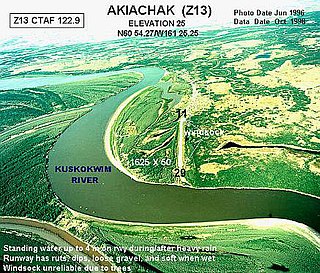
Akiak(ACK-ee-ack) is a city in Bethel Census Area, Alaska, United States. The population was 462 at the 2020 census, up from 346 in 2010. It is the home of the Akiak Native Community.

<span class="mw-page-title-main">Aniak, Alaska</span> City in Alaska, United States

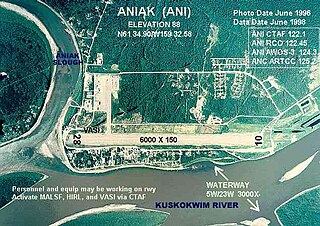
Aniak is a city in the Bethel Census Area in the U.S. state of Alaska. At the 2010 census the population was 501, down from 572 in 2000.

<span class="mw-page-title-main">Bethel, Alaska</span> City in Alaska, United States

Bethel is a city in the U.S. state of Alaska, located on the Kuskokwim River approximately 50 miles (80 km) from where the river discharges into Kuskokwim Bay. It is the largest community in western Alaska and in the Unorganized Borough and the eighth-largest in the state. Bethel has a population of 6,325 as of the 2020 census, up from 6,080 in 2010.

<span class="mw-page-title-main">Chefornak, Alaska</span> City in Alaska, United States

Chefornak is a city in Bethel Census Area, Alaska, United States. At the 2010 census its population was 418, up from 394 in 2000.

<span class="mw-page-title-main">Chuathbaluk, Alaska</span> City in Alaska, United States

Chuathbaluk is a city in Bethel Census Area, Alaska, United States.

<span class="mw-page-title-main">Eek, Alaska</span> City in Alaska, United States

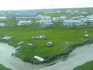
Eek is a city in Bethel Census Area, Alaska, United States. As of the 2020 census there were 404 residents, the majority being Alaska Natives.

<span class="mw-page-title-main">Kongiganak, Alaska</span> CDP in Alaska, United States

Kongiganak is a census-designated place (CDP) in Bethel Census Area, Alaska, United States, and primarily sits on the eastern shore of the Kongiganak River. As of the 2010 census, the population was 439, up from 359 in 2000.

<span class="mw-page-title-main">Kwethluk, Alaska</span> City in Alaska, United States

Kwethluk is a city in Bethel Census Area in the U.S. state of Alaska. At the 2010 census the population was 721, up from 713 in 2000. It is the birthplace of Saint Olga of Alaska

<span class="mw-page-title-main">Napakiak, Alaska</span> City in Alaska, United States

Napakiak is a city in Bethel Census Area, Alaska, United States. At the 2010 census the population was 354, up one resident from 353 since 2000.

<span class="mw-page-title-main">Quinhagak, Alaska</span> City in Alaska, United States

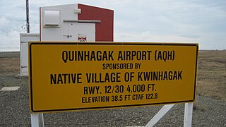
Quinhagak is a city in Bethel Census Area, Alaska, United States. As of the 2020 census, the population of the city is 776, up from 669 in 2010.

<span class="mw-page-title-main">Stony River, Alaska</span> Census-designated place in Alaska, United States

Stony River is a census-designated place (CDP) in Bethel Census Area, Alaska, United States. The population was 54 at the 2010 census, down from 61 in 2000.

Ohagamiut is an abandoned village along the Kuskokwim River in the Bethel Census Area of the southwestern part of the U.S. state of Alaska, located between Crow Village and Kalskag. It was abandoned in the 1940s as residents relocated to Kalskag, Aniak, Bethel and other towns. The village site is located just 3 miles east of Upper Kalskag.

Georgetown is an unincorporated Alaska Native village located in the Bethel Census Area of the U.S. state of Alaska. The population as of the 2010 census was 2, down from 3 in 2000.

<span class="mw-page-title-main">Crow Village Sam</span> Yupik leader, c. 1893–1974

"Crow Village" Sam Phillips was an Alaskan Native leader who lived in the mid-Kuskokwim River valley in Alaska.

<span class="mw-page-title-main">Southwest Alaska</span>

Southwest Alaska is a region of the U.S. state of Alaska. The area is not exactly defined by any governmental administrative region(s); nor does it always have a clear geographic boundary.

Napaimute is an unincorporated Alaska Native village located in the Bethel Census Area of the U.S. state of Alaska. It is classified as an Alaskan Native Village Statistical Area. As of the 2010 U.S. Census, it has a population of 2. This is up from a population of zero in 2000.

<span class="mw-page-title-main">Nushagak, Alaska</span> Unincorporated community in the state of Alaska, United States

Nushagak was a trade center and settlement near the present-day site of Dillingham, Alaska, United States, at the northern end of Nushagak Bay in northern Bristol Bay. It was located near the confluence of the Wood River and Nushagak Rivers.

<span class="mw-page-title-main">Yup'ik</span> Indigenous people of Alaska

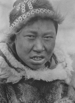
The Yupʼik or Yupiaq and Yupiit or Yupiat (pl), also Central Alaskan Yupʼik, Central Yupʼik, Alaskan Yupʼik, are an Indigenous people of western and southwestern Alaska ranging from southern Norton Sound southwards along the coast of the Bering Sea on the Yukon-Kuskokwim Delta and along the northern coast of Bristol Bay as far east as Nushagak Bay and the northern Alaska Peninsula at Naknek River and Egegik Bay. They are also known as Cup'ik by the Chevak Cup'ik dialect-speaking people of Chevak and Cup'ig for the Nunivak Cup'ig dialect-speaking people of Nunivak Island.

References

  1. U.S. Geological Survey Geographic Names Information System: Crow Village, Alaska
  2. "U.S. Decennial Census". Census.gov. Retrieved June 6, 2013.
  3. "Geological Survey Professional Paper". 1949.
  4. "Statistics of the Population of Alaska" (PDF). United States Census Bureau. 1880.
  5. "Report on Population and Resources of Alaska at the Eleventh Census: 1890" (PDF). United States Census Bureau. Government Printing Office.
  6. Oswalt, Wendell H.; Van-Stone, James W. (1967). "The Ethnoarcheology of Crow Village, Alaska".{{cite journal}}: Cite journal requires |journal= (help)
  7. "Central Yup'ik Eskimos." Countries and Their Cultures. Accessed February 9, 2014.
  8. Petroff, Ivan, (1884). "Report on the Population, Industries, and Resources of Alaska" Reprinted from U.S. 10th Census, Reports [1880] Washington, U.S. Census Office
  9. Hrdlička, Aleš. (1943) "Alaska Diary". The Jaques Cattell Press.
  10. Oswalt, Wendell H. & James W. Vanstone (1967). "The Ethnoarchaeology of Crow Village, Alaska" Coyote Press.