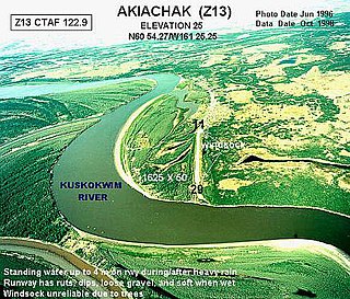
Akiachak is a census-designated place (CDP) in the Bethel Census Area in the U.S. state of Alaska. The population was 627 at the 2010 census, up from 585 in 2000.

Akiak(ACK-ee-ack) is a city in Bethel Census Area, Alaska, United States. The population was 462 at the 2020 census, up from 346 in 2010. It is the home of the Akiak Native Community.
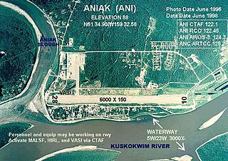
Aniak is a city in the Bethel Census Area in the U.S. state of Alaska. At the 2010 census the population was 501, down from 572 in 2000.

Eek is a city in Bethel Census Area, Alaska, United States. As of the 2020 census there were 404 residents, the majority of whom being Alaska Natives.

Stony River is a census-designated place (CDP) in Bethel Census Area, Alaska, United States. The population was 54 at the 2010 census, down from 61 in 2000.

Ninilchik is a census-designated place (CDP) in Kenai Peninsula Borough, Alaska, United States. At the 2010 census the population was 883, up from 772 in 2000.

Tyonek or Present / New Tyonek is a census-designated place (CDP) in Kenai Peninsula Borough in the U.S. state of Alaska. As of the 2020 census the population was 152, down from 171 in 2010. In 1973, the community formed the Tyonek Native Corporation (TNC) under the Alaska Native Claims Settlement Act and is federally recognized.
Ugashik is a census-designated place (CDP) in Lake and Peninsula Borough, Alaska, United States. The population was 4 at the 2020 census, down from 12 in 2010.
Marshall is a city in Kusilvak Census Area, Alaska, United States. At the 2010 census the population was 414, up from 349 in 2000.
Russian Mission is a city in Kusilvak Census Area, Alaska. It was the location of a fur trading post of the Russian-American Company in 1842. After the sale of Russian-American possessions to the United States in 1867, it was officially named Russian Mission in the early 1900s. The sale of alcohol is prohibited. At the 2010 census the population was 312, up from 296 in 2000.

McGrath is a city and village on the Kuskokwim River in Alaska, United States. The population was 301 at the 2020 census. Despite its small population, the village is an important transportation and economic hub for the area.
Ohagamiut is an abandoned village along the Kuskokwim River in the Bethel Census Area of the southwestern part of the U.S. state of Alaska, located between Crow Village and Kalskag. It was abandoned in the 1940s as residents relocated to Kalskag, Aniak, Bethel and other towns. The village site is located just 3 miles east of Upper Kalskag.
Telida is an unincorporated community located in the Yukon-Koyukuk Census Area in the U.S. state of Alaska. At the 2010 census the population was 3, unchanged from 2000.
Crow Village is an unincorporated community on the Kuskokwim River in the U.S. state of Alaska. There are an estimated six residents.

The Yukon–Kuskokwim Delta is a river delta located where the Yukon and Kuskokwim rivers empty into the Bering Sea on the west coast of the U.S. state of Alaska. At approximately 129,500 square kilometers (50,000 sq mi) in size, it is one of the largest deltas in the world. It is larger than the Mississippi River Delta ; it is comparable in size to the entire U.S. state of Louisiana. The delta, which consists mainly of tundra, is protected as part of the Yukon Delta National Wildlife Refuge.
Napaimute is an unincorporated Alaska Native village located in the Bethel Census Area of the U.S. state of Alaska. It is classified as an Alaskan Native Village Statistical Area. As of the 2010 U.S. Census, it has a population of 2. This is up from a population of zero in 2000.
Alexander is an unincorporated community in Matanuska-Susitna Borough, Alaska, United States. An Alaska Native community with an Alaska Native Village Corporation, it lies on the Susitna River delta, near the mouth of Alexander Creek, and 27 miles (43 km) northwest of Anchorage, Alaska Cook Inlet Low. It is located within the boundaries of Susitna CDP.
Paimuit is an unincorporated community in Kusilvak Census Area, Alaska, United States. It was unpopulated as of 2010, down from two residents in 2000. The nearest town is Hooper Bay, Alaska. The elevation is 30 feet. Paimiut is an Eskimo name meaning, "people of the stream's mouth". The town is on the east bank of the Lithkealik River.
Arolik is a former Yup'ik settlement and ghost town in Bethel Census Area, Alaska, United States. It was located at the North mouth of Arolik River adjacent to the shore of Kuskokwim Bay. The site is approximately 4 miles south of the city of Quinhagak. It was first surveyed for the 1880 U.S. Census by Ivan Petroff and reported as "Agaligamute".
Agivavik is a former Inuit settlement and ghost town in Dillingham Census Area, Alaska, United States. It was located on the west bank of the Nushagak River. The site is approximately 6 miles southwest of the city of New Stuyahok and 3 miles northeast of the city of Ekwok. It was initially noted by the Nushagak Russian Orthodox Church vital statistics in 1863 and was visited by a missionary. In 1879, it was noted to have 47 residents. A Father Vasili Shishkin visited the settlement in 1882 and noted it was "one of only three" occupied villages along the river. The 1880 census did not mention the number of homes occupied, though the 1890 census stated there were two.

