Related Research Articles

Lime Village is a census-designated place (CDP) in Bethel Census Area, Alaska, United States. The 2020 census found a population of 13, down from 29 in 2010. It has also been known as Hungry Village.

Anvik is a city, home to the Deg Hit'an people, in the Yukon-Koyukuk Census Area, Alaska, United States. The name Anvik, meaning "exit" in the Central Alaskan Yup'ik language, became the common usage despite multiple names at the time, and may have come from early Russian explorers. The native name in the Deg Xinag language is Deloy Ges. The population was 85 at the 2010 census, down from 104 in 2000.
Grayling is a city in Yukon-Koyukuk Census Area, Alaska, United States. At the 2010 census the population was 194, unchanged from 2000. Since 1977, the Athabaskan village has seen a surge of interest on odd-numbered years, when it is the site of a checkpoint during the Iditarod Trail Sled Dog Race. It is situated after the checkpoint at Anvik and before Eagle Island.
Lake Minchumina is a census-designated place (CDP) in Yukon-Koyukuk Census Area, Alaska, United States. As of the 2022 data usa, the population of the CDP is 14.

McGrath is a city and village on the Kuskokwim River in Alaska, United States. The population was 301 at the 2020 census. Despite its small population, the village is an important transportation and economic hub for the area.

The Iditarod Trail Sled Dog Race, more commonly known as The Iditarod, is an annual long-distance sled dog race held in Alaska in early March. It travels from Anchorage to Nome. Mushers and a team of between 12 and 16 dogs, of which at least 5 must be on the towline at the finish line, cover the distance in 8–15 days or more. The Iditarod began in 1973 as an event to test the best sled dog mushers and teams but evolved into today's highly competitive race.

The Kuskokwim River or Kusko River is a river, 702 miles (1,130 km) long, in Southwest Alaska in the United States. It is the ninth largest river in the United States by average discharge volume at its mouth and seventeenth largest by basin drainage area. The Kuskokwim River is the longest river system contained entirely within a single U.S. state.
Telida is an unincorporated community located in the Yukon-Koyukuk Census Area in the U.S. state of Alaska. At the 2010 census the population was 3, unchanged from 2000.

The Iditarod Trail, also known historically as the Seward-to-Nome Trail, is a thousand-plus mile (1,600 km) historic and contemporary trail system in the US state of Alaska. The trail began as a composite of trails established by Alaskan native peoples. Its route crossed several mountain ranges and valleys and passed through numerous historical settlements en route from Seward to Nome. The discovery of gold around Nome brought thousands of people over this route beginning in 1908. Roadhouses for people and dog barns sprang up every 20 or so miles. By 1918 World War I and the lack of 'gold fever' resulted in far less travel. The trail might have been forgotten except for the 1925 diphtheria outbreak in Nome. In one of the final great feats of dog sleds, twenty drivers and teams carried the life-saving serum 674 miles (1,085 km) in 127 hours. Today, the Iditarod Trail Sled Dog Race serves to commemorate the part the trail and its dog sleds played in the development of Alaska, and the route and a series of connecting trails have been designated Iditarod National Historic Trail.

The Yukon Quest, formally the Yukon Quest 1,000-mile International Sled Dog Race, is a sled dog race scheduled every February since 1984 between Fairbanks, Alaska, and Whitehorse, Yukon, switching directions each year. Because of the harsh winter conditions, difficult trail, and the limited support that competitors are allowed, it is considered the "most difficult sled dog race in the world", or even the "toughest race in the world"—"even tougher, more selective and less attention-seeking than the Iditarod Trail Sled Dog Race." The originator envisioned it as "a race so rugged that only purists would participate."
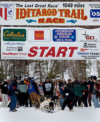
The ceremonial start of the 33rd annual Iditarod Trail Sled Dog Race across the US state of Alaska began in Anchorage on March 5, 2005, at 10 am AKST, and restarted in Willow the next day at 2 pm. After covering 1,161 miles (1,868 km) of wilderness, musher Robert Sørlie, an airport firefighter from Norway, crossed the finish line under the "burled arch" in Nome on March 16 at 8:39 am AKST. After taking care of his dogs, and an inspection to make sure all the mandatory equipment was in his sled, Sørlie was declared the winner by Race Marshal Mark Norman, with a time of 9 days, 18 hours, 39 minutes, and 31 seconds and won US$72,066.67 and a new truck. When asked how it felt to win a second time, Sørlie said "it feels good, I'm ready for breakfast." His team of dogs averaged 4.65 mi/h (7.58 km/h). The Red Lantern in last was Phil Morgan, an Alaska Airlines pilot, and when he crossed the finish line on March 21 at 8:02 pm AKST, the Widow's Lantern hanging on the burled arch was extinguished, which signaled the end of the race.
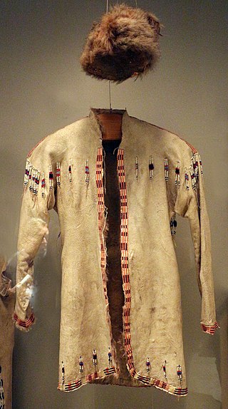
Deg Hitʼan is a group of Athabaskan peoples in Alaska. Their native language is called Deg Xinag. They reside in Alaska along the Anvik River in Anvik, along the Innoko River in Shageluk, and at Holy Cross along the lower Yukon River.

Chugach State Park covers 495,204 acres covering a hilly region immediately east of Anchorage, in south-central Alaska.

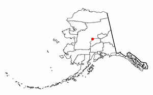
The Unorganized Borough is composed of the portions of the U.S. state of Alaska which are not contained in any of its 19 organized boroughs. While referred to as the "Unorganized Borough", it is not a borough itself, as it forgoes that level of government structure. It encompasses nearly half of Alaska's land area, 323,440 square miles (837,700 km2), and, as of the 2020 U.S. Census, it had a population of 77,157, which was 10.52% of the population of the state. The largest communities in the Unorganized Borough are the cities of Bethel, Unalaska, and Valdez.
The ceremonial start of the 34th annual (XXXIV) Iditarod Trail Sled Dog Race across the U.S. state of Alaska began amidst the crowds of Anchorage on March 4, 2006, and the start of the competitive race, or "restart", began the next day in Willow. The race followed a modified version of the northern route for 1,151 mi (1,852 km) across the Alaska Range, through the sparsely inhabited Interior, along the Yukon River, and then up the coast of the Bering Sea to the city of Nome. Unlike in previous years, where the teams had to deal with unseasonably warm temperatures and soft, mushy snow, the weather was cold, with temperatures reported as low as −40 °F (−40 °C).
Holikachuk is a recently extinct Athabaskan language formerly spoken at the village of Holikachuk (Hiyeghelinhdi) on the Innoko River in central Alaska. In 1962, residents of Holikachuk relocated to Grayling on the lower Yukon River. Holikachuk is intermediate between the Deg Xinag and Koyukon languages, linguistically closer to Koyukon but socially much closer to Deg Xinag. Though it was recognized by scholars as a distinct language as early as the 1840s, it was only definitively identified in the 1970s. Of about 180 Holikachuk people, only about 5 spoke the language in 2007. In March 2012, the last living fluent speaker of Holikachuk died in Alaska.
The ceremonial start of the 35th annual Iditarod Trail Sled Dog Race across the U.S. state of Alaska began amidst the crowds of Anchorage at 10 am (AKST) on March 3, 2007, and the start of the competitive race, or "restart", began at 2 pm the next day in Willow. The race followed the southern route for 1,151 mi (1,852 km) across the Alaska Range, through the sparsely inhabited Interior, along the Yukon River, and then up the coast of the Bering Sea to the city of Nome.

The Upper Kuskokwim people or Upper Kuskokwim Athabaskans, Upper Kuskokwim Athabascans, and historically Kolchan, Goltsan, Tundra Kolosh, and McGrath Ingalik are an Alaskan Athabaskan people of the Athabaskan-speaking ethnolinguistic group. First delineation of this ethnolinguistic group was described by anthropologist Edward Howard Hosley in 1968, as Kolchan. According to Hosley, "Nevertheless, as a group possessing a history and a culture differing from those of its neighbours, the Kolchan deserve to be recognized as an independent group of Alaskan Athapaskans." They are the original inhabitants of the Upper Kuskokwim River villages of Nikolai, Telida, and McGrath, Alaska. About 25 of a total of 100 Upper Kuskokwim people still speak the language. They speak a distinct Athabaskan language more closely related to Lower Tanana language than to Deg Xinag language, spoken on the middle Kuskokwim. The term used by the Kolchan themselves is Dina'ena, but this is too similar to the adjacent Tanana and Tanaina for introduction into the literature. Nowadays, the term used by the Kolchan themselves is Dichinanek' Hwt'ana. Their neighbors also knew them by this name. In Tanaina they were Kenaniq' ht'an while the Koyukon people to the north referred to them as Dikinanek Hut'ana. The Upper Kuskokwim Athabaskan culture is a hunter-gatherer culture and have a matrilineal system. They were semi-nomadic and lived in semi-permanent settlements.
Copper River School District (CRSD) is a school district headquartered in Glennallen, Alaska. CRSD is known for being made up of several schools. The schools at times collaborate to achieve new educational opportunities. This is done primarily by VTC, or by transportation of students to either of the three schools.
References
- 1 2 3 4 5 6 "Search for Public School Districts – District Detail for Iditarod Area School District". National Center for Education Statistics . Institute of Education Sciences . Retrieved March 5, 2022.
- ↑ "Personnel Directory Archived 2017-03-28 at the Wayback Machine ." Iditarod Area School District. Retrieved on March 28, 2017.
- ↑ "IASD Distance Learning Center Archived 2017-03-28 at the Wayback Machine ." Iditarod Area School District. Retrieved on March 28, 2017. "19111 Stephanie Blvd. Eagle River, AK 99577"
- 1 2 "Schools." Iditarod Area School District. October 16, 2001. Retrieved on March 28, 2017.
- ↑ Solberg, Dustin (December 14, 2007). "Dwindling numbers close school in Lime Village". Bristol Bay Times at Juneau Empire. Archived from the original on March 28, 2017. Retrieved March 28, 2017.
- ↑ "Map of the Alaska School Districts (2013)." Alaska Department of Education. Retrieved on March 12, 2017.