
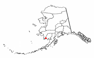
Dillingham Census Area is a census area located in the state of Alaska, United States. At the 2020 census, the population was 4,857, slightly up from 4,847 in 2010. It is part of the unorganized borough and therefore has no borough seat. Its largest community by far is the city of Dillingham, on a small arm of Bristol Bay on the Bering Sea.
Aleknagik is a second class city in the Dillingham Census Area of the Unorganized Borough of the U.S. state of Alaska. The population was 219 at the 2010 census, down from 221 in 2000.

Dillingham, also known as Curyung, is a city in Dillingham Census Area, Alaska, United States. Incorporated in 1963, it is an important commercial fishing port on Nushagak Bay. As of the 2020 census, the population of the city was 2,249, down from 2,329 in 2010.

Koliganek is a census-designated place (CDP) in Dillingham Census Area, Alaska, United States. It is located along the Nushagak River At the 2010 census, the population was 209, up from 182 in 2000.
Manokotak is a city in Dillingham Census Area, Alaska, United States. At the 2010 census the population was 442, up from 399 in 2000.

Portage Creek is a census-designated place (CDP) in Dillingham Census Area, Alaska, United States. The population was 2 at the 2010 census, down from 36 at the 2000 census.
Togiak is a city in Dillingham Census Area, Alaska, United States. At the 2010 census the population was 817, up from 809 in 2000.
Twin Hills is a census-designated place (CDP) in Dillingham Census Area, Alaska, United States. The population was 74 at the 2010 census, up from 69 in 2000.
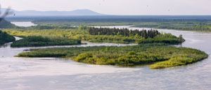
The Nushagak River is a river in southwest Alaska, United States. It begins in the Alaska Range and flows southwest 450 km (280 mi) to Nushagak Bay, an inlet of Bristol Bay, east of Dillingham, Alaska.

The Mulchatna River (Dena'ina: Vałts'atnaq') is a 160-mile (260 km) tributary of the Nushagak River in the U.S. state of Alaska. Beginning at Turquoise Lake, it flows generally southwest to meet the larger river 65 miles (105 km) northeast of Dillingham. The Mulchatna's mouth is slightly south (downstream) of the village of Koliganek on the Nushagak, which continues southwest to Nushagak Bay, an arm of Bristol Bay.

Alaska Central Express is an airline based at Ted Stevens Anchorage International Airport in Anchorage, Alaska, United States. It is a cargo and small package express service.

Aleknagik Airport, also known as Aleknagik (New) Airport, is a state-owned, public-use airport located one nautical mile (1.85 km) east of the central business district of Aleknagik, a city in the Dillingham Census Area of the U.S. state of Alaska.

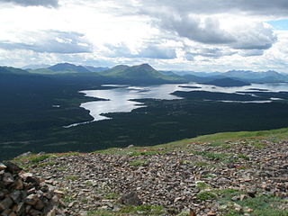
Wood-Tikchik State Park is a state park in the U.S. state of Alaska north of Dillingham. Over 1,600,000 acres (650,000 ha) (6,500 km2) in area—about the size of the state of Delaware—, comprising more than half of all state park land in Alaska and 15% of the total state park land in the country. Despite being the largest state park in the nation, the park had no staff whatsoever for its first five years, and even now at times only a single ranger is in charge of patrolling the entire park, usually by aircraft.

Southwest Alaska is a region of the U.S. state of Alaska. The area is not exactly defined by any governmental administrative region(s); nor does it always have a clear geographic boundary.

Bryce Edgmon is a member of the Alaska House of Representatives, representing the 37th District since 2006. He served as speaker from 2019-2021. The district includes all or portions of the Kodiak Island Borough, Aleutians East Borough, Lake and Peninsula Borough, Bristol Bay Borough, and the Yukon–Koyukuk Census Area.

Koliganek Airport is a state-owned, public-use airport located one nautical mile (1.85 km) east of the central business district of Koliganek, in the Dillingham Census Area of the U.S. state of Alaska. Scheduled airline service to Dillingham Airport is provided by Peninsula Airways (PenAir).
The UAF Bristol Bay Campus (BBC) is one of several rural campuses administered by the University of Alaska Fairbanks system. The campus is located in Dillingham, Alaska, and serves the many remote communities of Bristol Bay, Alaska Peninsula, Pribilof Islands, and the Aleutian regions of southwest Alaska. There are learning centers in Dillingham, King Salmon, Togiak, New Stuyahok, St. Paul, and Unalaska. BBC focuses on serving Alaska Native and non-traditional students by offering online, audio, and face-to-face learning opportunities. BBC believes that all students have a right to an education that provides opportunities and expands life choices relevant to the students’ cultures within their local communities.
The Portage Glacier Highway, or Portage Glacier Road, is a highway located in the U.S. state of Alaska. The highway is made up of a series of roads, bridges, and tunnels that connect the Portage Glacier area of the Chugach National Forest and the city of Whittier to the Seward Highway. Most of the highway travels through mainly rural areas just north of the Kenai Peninsula, with the Anton Anderson Memorial Tunnel passing under Maynard Mountain, part of the Chugach Mountain Range. Parts of the route were first constructed in the early 1900s, and the entire highway was completed on June 7, 2000, as part of the Whittier Access Project. The main portion of the highway traveling from the western terminus to the Begich, Boggs visitors center is designated as National Forest Highway 35 by the United States Forest Service (USFS).
Aleutian Region School District is a school district headquartered in Anchorage, Alaska. It serves the Aleutian Islands west of Unalaska, including Adak, Atka, and Nikolski. ARSD is the school district in the United States that is both the farthest east and the farthest west. Several uninhabited islands, including Attu and Shemya, are within the district's physical boundaries.