Related Research Articles

Interior Alaska is the central region of Alaska's territory, roughly bounded by the Alaska Range to the south and the Brooks Range to the north. It is largely wilderness. Mountains include Denali in the Alaska Range, the Wrangell Mountains, and the Ray Mountains. The native people of the interior are Alaskan Athabaskans. The largest city in the interior is Fairbanks, Alaska's second-largest city, in the Tanana Valley. Other towns include North Pole, just southeast of Fairbanks, Eagle, Tok, Glennallen, Delta Junction, Nenana, Anderson, Healy and Cantwell. The interior region has an estimated population of 113,154.

Yukon–Koyukuk Census Area is a census area in the U.S. state of Alaska. As of the 2020 census, the population was 5,343, down from 5,588 in 2010. With an area of 147,842.51 sq mi (382,910.3 km2), it is the largest of any county or county-equivalent in the United States, or about the same size as the state of Montana. It is part of the unorganized borough of Alaska and therefore has no borough seat. Its largest communities are the cities of Galena, in the west, and Fort Yukon, in the northeast.

Arctic Village is an unincorporated Native American village and a census-designated place (CDP) in Yukon-Koyukuk Census Area, Alaska, United States. As of the 2010 census, the population of the CDP was 152. This was unchanged from 2000. The village is located in the large Gwitch'in speaking region of Alaska, and the local dialect is known as Di'haii Gwitch'in or shahanh. As of 1999, over 95% of the community speaks and understands the language.

Beaver is a census-designated place (CDP) in Yukon-Koyukuk Census Area, Alaska, United States. At the 2010 census the population was 84, unchanged from 2000.

Bettles is a city in Yukon-Koyukuk Census Area, Alaska, United States. It is near Gates of the Arctic National Park and Preserve. The population was 23 at the 2020 census, up from 12 in 2010. It is the second smallest incorporated city in the state.
Birch Creek is a census-designated place (CDP) in Yukon-Koyukuk Census Area, Alaska, United States. The population was 33 at the 2010 census, up from 28 in 2000.

Circle is a census-designated place (CDP) in Yukon-Koyukuk Census Area, Alaska, United States. At the 2010 census the population was 104, up from 100 in 2000.

Fort Yukon is a city in the Yukon-Koyukuk Census Area in the U.S. state of Alaska, straddling the Arctic Circle. The population, predominantly Gwich'in Alaska Natives, was 583 at the 2010 census, down from 595 in 2000.

Stevens Village is a census-designated place (CDP) in Yukon-Koyukuk Census Area, Alaska, United States. The population was 78 at the 2010 census, down from 87 in 2000.

Venetie, is a census-designated place (CDP) in Yukon–Koyukuk Census Area, Alaska. At the 2010 census, the population was 166, down from 202 in 2000. It includes the Village of Venetie, a Gwich'in tribal entity designated in the 1971 Alaska Native Claims Settlement Act.

The Gwichʼin language belongs to the Athabaskan language family and is spoken by the Gwich'in First Nation (Canada) / Alaska Native People. It is also known in older or dialect-specific publications as Kutchin, Takudh, Tukudh, or Loucheux. Gwich'in is spoken primarily in the towns of Inuvik, Aklavik, Fort McPherson, and Tsiigehtchic, all in the Northwest Territories and Old Crow in Yukon of Canada. In Alaska of the United States, Gwichʼin is spoken in Beaver, Circle, Fort Yukon, Chalkyitsik, Birch Creek, Arctic Village, Eagle, and Venetie.

The Gwichʼin are an Athabaskan-speaking First Nations people of Canada and an Alaska Native people. They live in the northwestern part of North America, mostly above the Arctic Circle.
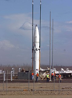
Fort Greely is a United States Army launch site for anti-ballistic missiles located about 100 miles (160 km) southeast of Fairbanks, Alaska. It is also the home of the Cold Regions Test Center (CRTC), as Fort Greely is one of the coldest areas in Alaska, and can accommodate cold, extreme-cold, and temperate-weather tests depending on the season. It is named in honor of Major General Adolphus Greely.

Birch Creek is a 150-mile (240 km) tributary of the Yukon River in the U.S. state of Alaska. Beginning at the confluence of Ptarmigan and Eagle creeks near Porcupine Dome, it flows southwest, then south under the Steese Highway and into the Steese National Conservation Area. It then turns east, then north, again passing under the Steese Highway and entering the Yukon Flats National Wildlife Refuge. Turning northwest, it ends where it splits into two distributaries, Lower Mouth Birch Creek and Upper Mouth Birch Creek, near Birch Creek, Alaska. The distributaries flow into the Yukon River at separate locations downstream of Fort Yukon.

Arctic Circle Air was an American airline based in Fairbanks, Alaska, USA. It operated scheduled commuter services and charter flights to over 16 Alaskan communities. It was established and started operations in 1973. Its main base was Fairbanks International Airport.
There are several lakes named Mud Lake within the U.S. state of Alaska.

Warbelow's Air Ventures is an American regional airline based in Fairbanks, Alaska, United States. It operates domestic scheduled passenger, charter, and tour services as well as flight tours, mostly throughout Interior Alaska. Its base is Fairbanks International Airport.

The Yukon Flats are a vast area of wetlands, forest, bog, and low-lying ground centered on the confluence of the Yukon River, Porcupine River, and Chandalar River in the central portion of the U.S. state of Alaska. The Yukon Flats are bordered in the north by the Brooks Range, in the south by the White Mountains, and cover an area of approximately 11,000 square miles (28,490 km2). The Yukon Flats are a critical waterfowl breeding ground due to the large area of wetland provided by the estimated 40,000 small lakes and streams in the area. In recognition of this fact, the area is protected under the Yukon Flats National Wildlife Refuge.
Circle Hot Springs is a hot spring and an unincorporated community in the Yukon-Koyukuk Census Area of Alaska in the United States. The community is home to a hot spring and is the site of the now-closed Arctic Circle Hot Springs resort. The hot spring can be accessed either by automobile via the Steese Highway or by plane via the small-scale Circle Hot Springs Airport. The area surrounding the hot spring is rich in mining history and retains a certain degree of mystery and folklore.
Gwichyaa Gwichʼin are a Gwich'in people who live in the Yukon Flats area of Alaska, USA. This includes the Fort Yukon area on both banks of the Yukon River from Birch Creek to Porcupine River;" the Senati 65.266°N 151.183°W area of the middle Yukon River, the namesake of Sahneuti, Gwich'in chief and fur trader; and Venetie.
References
- ↑ "https://yfsd.org/ Mailing Addresses and Contact Information ]." Yukon Flats School District. Retrieved on December 4, 2016.
- ↑ "Alaska School Map." Alaska Department of Education. 2013. Retrieved on March 13, 2017.
- ↑ "Yukon Flats School District" . Retrieved August 23, 2020.