Beaver, Alaska

Last updated

Beaver
Ts'aahudaaneekk'onh Denh
CDP
Figure 3- A Building in Beaver, Alaska Serviced with a Satellite Internet Connection (25229851546).jpg
A house in Beaver, February 2016
AKMap-doton-Beaver.PNG
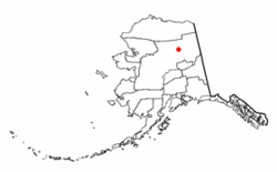
Location of Beaver, Alaska
Coordinates: 66°21′35″N147°23′51″W / 66.35972°N 147.39750°W / 66.35972; -147.39750
Country United States
State Alaska
Census Area Yukon-Koyukuk
Government
   State senator Click Bishop (R)
   State rep. Mike Cronk (R)
Area
[1]
  Total21.04 sq mi (54.51 km2)
  Land20.52 sq mi (53.14 km2)
  Water0.53 sq mi (1.36 km2)
Population
 (2020) [2]
  Total48
  Density2.34/sq mi (0.90/km2)
Time zone UTC-9 (Alaska (AKST))
  Summer (DST) UTC-8 (AKDT)
ZIP code
99724
Area code 907
FIPS code 02-05750
Beaver airstrip, 1944 Landing Fields - Alaska - Beaver - NARA - 68158704 (cropped).jpg
Beaver airstrip, 1944

Beaver (Ts'aahudaaneekk'onh Denh in Koyukon) is a census-designated place (CDP) in Yukon-Koyukuk Census Area, Alaska, United States. At the time of the 2010 census the population was 84, unchanged from 2000, however the 2020 census reported a total population of 48. [3]

Contents

Geography

Beaver is located at 66°21′35″N147°23′51″W / 66.359719°N 147.397438°W / 66.359719; -147.397438 . [4]

According to the United States Census Bureau, the CDP has a total area of 21.6 square miles (56 km2), of which, 20.5 square miles (53 km2) of it is land and 1.1 square miles (2.8 km2) of it (5.05%) is water.

Demographics

Historical population
CensusPop.Note
1930 103
1940 88−14.6%
1950 10114.8%
1960 1010.0%
1970 1010.0%
1980 66−34.7%
1990 10356.1%
2000 84−18.4%
2010 840.0%
2020 48[ citation needed ]−42.9%
U.S. Decennial Census [5] [ failed verification ]

Beaver first appeared on the 1930 U.S. Census as an unincorporated village. [6] It is unusual for having had just three different population figures on 7 out of 9 censuses (103 in 1930 & 1990; 101 in 1950-70 & 84 in 2000-10) and an identical (unchanged) population on 5 different censuses (101 in 1950, 1960 & 1970 and 84 in 2000 and 2010). Beaver became a census-designated place (CDP) in 1980. [7]

2020 Census

As of the 2020 Census, [3] there were a reported 48 inhabitants across 41 households and 57 housing units within the CDP. The population density was 2.34 inhabitants per square mile (0.9/km2). The racial makeup was 95.83% Native American, 2.08% White, and 2.08% Hispanic or Latino.

The median household income was $36,964 and the median incomes for families was $46,250, both of which remained far below the Alaska median household income of $88,121. The poverty rate was 26.2%, including 61.1% of people under 18 years old and 24.4% of those aged 18 to 64 years.

The employment rate was 72.7%, with 70.8% of workers being in local, state, or federal employees, 22.9% being employees of private companies, and 6.3% being employed by private not-for-profits. As for transportation, 100% of workers 16 years old and over walked to work, with the average commute time being 5.6 minutes.

2000 Census

As of the census [8] of 2000, there were 84 people, 31 households, and 19 families residing in the CDP. The population density was 4.1 inhabitants per square mile (1.6/km2). There were 54 housing units at an average density of 2.6 per square mile (1.0/km2). The racial makeup of the CDP was 4.76% White, 85.71% Native American, and 9.52% from two or more races.

There were 31 households, out of which 41.9% had children under the age of 18 living with them, 12.9% were married couples living together, 32.3% had a female householder with no husband present, and 38.7% were non-families. 29.0% of all households were made up of individuals, and 6.5% had someone living alone who was 65 years of age or older. The average household size was 2.71 and the average family size was 3.42.

In the CDP, the population was spread out, with 40.5% under the age of 18, 4.8% from 18 to 24, 32.1% from 25 to 44, 15.5% from 45 to 64, and 7.1% who were 65 years of age or older. The median age was 29 years. For every 100 females, there were 154.5 males. For every 100 females age 18 and over, there were 163.2 males.

The median income for a household in the CDP was $28,750, and the median income for a family was $29,792. Males had a median income of $26,667 versus $16,875 for females. The per capita income for the CDP was $8,441. There were no families and 11.1% of the population living below the poverty line, including no under eighteens and none of those over 64.

Education

Yukon Flats School District operates the Cruikshank School. [9]

Health

Sale, importation and possession of alcohol are banned in the village. [10]

See also

Related Research Articles

<span class="mw-page-title-main">Cantwell, Alaska</span> Census-designated place in Alaska, United States

Cantwell is a census-designated place (CDP) in Denali Borough, Alaska, United States. As of the 2020 census, the population of the CDP was 200.

<span class="mw-page-title-main">College, Alaska</span> Census-designated place in Alaska, United States

College is a census-designated place (CDP) in Fairbanks North Star Borough, Alaska, United States. It is part of the Fairbanks, Alaska Metropolitan Statistical Area. As of the 2020 census, the population was 11,332, down from 12,964 in 2010. College is the third-most populated CDP in Alaska.

<span class="mw-page-title-main">Moose Creek, Alaska</span> CDP in Alaska, United States

Moose Creek is a census-designated place (CDP) in Fairbanks North Star Borough in the U.S. state of Alaska. As of the 2010 census, the population of the CDP was 747, up from 542 in 2000. It is part of the Fairbanks, Alaska Metropolitan Statistical Area. Moose Creek is located south of Fairbanks, Alaska along the Richardson Highway. Moose Creek is bordered by Eielson Air Force Base to the south, the Tanana River to the west, and the Chena River Flood Control Project to the north.

<span class="mw-page-title-main">Salcha, Alaska</span> Census-designated place in Alaska, United States

Salcha is a census-designated place (CDP) in Fairbanks North Star Borough in the U.S. state of Alaska. It is part of the Fairbanks, Alaska Metropolitan Statistical Area. The population was 1,095 at the 2010 census, up from 854 in 2000.

<span class="mw-page-title-main">Two Rivers, Alaska</span> CDP in Alaska, United States

Two Rivers is a census-designated place (CDP) in Fairbanks North Star Borough, Alaska, United States. It lies between mile 13 and mile 25 on the Chena Hot Springs Road, northeast of Fairbanks. As of the 2010 United States Census, the CDP had a population of 719, up from 482 in 2000.

<span class="mw-page-title-main">Mosquito Lake, Alaska</span> Census-designated place in Alaska, United States

Mosquito Lake is a census-designated place (CDP) in Haines Borough, Alaska, United States. At the 2010 census the population was 309, up from 221 at the 2000 census.

<span class="mw-page-title-main">Glacier View, Alaska</span> Census-designated place in Alaska, United States

Glacier View is a census-designated place (CDP) in Matanuska-Susitna Borough, Alaska, United States. It is part of the Anchorage Metropolitan Area. At the 2020 census the population was 375, up from 234 in 2010. The terminus of Matanuska Glacier is located approximately three miles southwest of Glacier View.

<span class="mw-page-title-main">Alcan Border, Alaska</span> Census-designated place in Alaska, United States

Alcan Border, also known as Port Alcan, is a census-designated place in the Southeast Fairbanks Census Area in the U.S. state of Alaska. Part of the Unorganized Borough, Alcan Border is the site of the Alcan - Beaver Creek Border Crossing, the main U.S. port of entry for persons arriving in Alaska by road. The population was 33 at the 2010 census, up from 21 in 2000.

<span class="mw-page-title-main">Dot Lake, Alaska</span> CDP in Alaska, United States

Dot Lake is a census-designated place (CDP) in Southeast Fairbanks Census Area, Alaska, United States. It is located on the Alaska Highway between Delta Junction and Tok. The population was 13 at the 2010 census, down from 19 in 2000.

<span class="mw-page-title-main">Eagle Village, Alaska</span> CDP in Alaska, United States

Eagle Village is a census-designated place (CDP) in Southeast Fairbanks Census Area, Alaska, United States. The population was 67 at the 2010 census.

<span class="mw-page-title-main">Mentasta Lake, Alaska</span> CDP in Alaska, United States

Mentasta Lake is a census-designated place (CDP) in Copper River Census Area, Alaska, United States. At the 2010 census the population was 112, down from 142 in 2000.

Birch Creek is a census-designated place (CDP) in Yukon-Koyukuk Census Area, Alaska, United States. The population was 33 at the 2010 census, up from 28 in 2000.

<span class="mw-page-title-main">Central, Alaska</span> CDP in Alaska, United States

Central is a census-designated place (CDP) in Yukon-Koyukuk Census Area, Alaska, United States. At the 2010 census the population was 96, down from 134 in 2000. Every February, Central hosts a checkpoint for the long-distance Yukon Quest sled dog race.

<span class="mw-page-title-main">Chalkyitsik, Alaska</span> CDP in Alaska, United States

Chalkyitsik, meaning "to fish with a hook, at the mouth of the creek", is a census-designated place (CDP) in Yukon-Koyukuk Census Area, Alaska, United States. It is located on the left (south) bank of the Black River, 45 miles northeast of Fort Yukon. At the 2010 census the population was 69, down from 83 in 2000.

<span class="mw-page-title-main">Circle, Alaska</span> CDP in Alaska, United States

Circle is a census-designated place (CDP) in Yukon-Koyukuk Census Area, Alaska, United States. At the 2010 census the population was 104, up from 100 in 2000.

Four Mile Road is a census-designated place (CDP) in Yukon-Koyukuk Census Area, Alaska, United States. The population was 43 at the 2010 census, up from 38 in 2000.

<span class="mw-page-title-main">Lake Minchumina, Alaska</span> CDP in Alaska, United States

Lake Minchumina is a census-designated place (CDP) in Yukon-Koyukuk Census Area, Alaska, United States. As of the 2020 census, the population of the CDP is 30.

<span class="mw-page-title-main">New Allakaket, Alaska</span> CDP in Alaska, United States

New Allakaket was a census-designated place (CDP) in Yukon-Koyukuk Census Area, Alaska, United States. The population was 66 at the 2010 census, up from 36 in 2000. In March 2015, neighboring Allakaket annexed New Allakaket.

<span class="mw-page-title-main">Stevens Village, Alaska</span> CDP in Alaska, United States

Stevens Village is a census-designated place (CDP) in Yukon-Koyukuk Census Area, Alaska, United States. The population was 78 at the 2010 census, down from 87 in 2000.

<span class="mw-page-title-main">Wiseman, Alaska</span> CDP in Alaska, United States

Wiseman is a census-designated place (CDP) in Yukon-Koyukuk Census Area, Alaska, United States. The full time resident population is 12 as of 2022.

References

  1. "2020 U.S. Gazetteer Files". United States Census Bureau. Retrieved October 29, 2021.
  2. https://data.census.gov/profile/Beaver_CDP,_Alaska?g=160XX00US0205750
  3. 1 2 "Explore Census Data". data.census.gov. Retrieved April 6, 2024.
  4. "US Gazetteer files: 2010, 2000, and 1990". United States Census Bureau. February 12, 2011. Retrieved April 23, 2011.
  5. "U.S. Decennial Census". Census.gov. Retrieved June 6, 2013.
  6. Alaska
  7. Number of Inhabitants. Alaska
  8. "U.S. Census website". United States Census Bureau . Retrieved January 31, 2008.
  9. "Mailing Addresses and Contact Information Archived 2016-12-20 at the Wayback Machine ." Yukon Flats School District. Retrieved on December 4, 2016.
  10. "Schedule of Local Option Communities" (PDF). Alcoholic Beverage Control Board. Retrieved May 3, 2023.

Commons-logo.svg Media related to Beaver, Alaska at Wikimedia Commons