Wiseman, Alaska

Last updated

Wiseman, Alaska
CDP
Wiseman Alaska post office.jpg
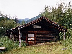
The log-built post office at Wiseman, seen here in 1995, has been sinking into the ground for the past century, and is now a couple of feet below ground.
AKMap-doton-Wiseman.PNG
Location of Wiseman, Alaska
Coordinates: 67°24′34″N150°6′35″W / 67.40944°N 150.10972°W / 67.40944; -150.10972
Country United States
State Alaska
Census Area Yukon-Koyukuk
Government
   State senator Click Bishop (R)
   State rep. Mike Cronk (R)
Area
[1]
  Total78.03 sq mi (202.11 km2)
  Land78.01 sq mi (202.05 km2)
  Water0.02 sq mi (0.05 km2)
Elevation
1,181 ft (360 m)
Population
 (2020)
  Total5
  Density0.06/sq mi (0.02/km2)
Time zone UTC-9 (Alaska (AKST))
  Summer (DST) UTC-8 (AKDT)
ZIP code
99726 [2]
Area code 907
FIPS code 02-85610
GNIS feature ID1414284

Wiseman is a census-designated place (CDP) in Yukon-Koyukuk Census Area, Alaska, United States. The full time resident population is 12 as of 2022.

Contents

Wiseman is a small mining community along the Middle Fork Koyukuk River in the Brooks Range. It was founded by gold miners who abandoned the Slate Creek (later Coldfoot) settlement around 1908. Another small mining village (Nolan, on Nolan creek - to the north) survived into the 1970s.

Robert Marshall, who became a prominent American forester, preservation activist, and a co-founder of The Wilderness Society, wrote the bestselling book, Arctic Village, about his 15-month stay in this frontier town around the year 1930. Marshall described Wiseman and the Koyukuk River area surrounding it, as "the happiest civilization of which I have knowledge." [3] Marshall called Noel Wien's first flight there on May 5, 1925, "one of the great events in Koyukuk history." [4] [5]

The community is 3 miles (5 km) from the Dalton Highway, and it was not connected to the road until the early 1990s.

Geography

Wiseman is located at 67°26′0″N150°5′40″W / 67.43333°N 150.09444°W / 67.43333; -150.09444 (67.433355, -150.094376). [6]

According to the United States Census Bureau, the CDP has a total area of 78.1 square miles (202 km2), of which, 78.1 square miles (202 km2) of it is land and 0.04 square miles (0.10 km2) of it (0.05%) is water. The town is bisected by Wiseman Creek.

Climate

Wiseman has a subarctic climate (Köppen Dfc). Summers are short and mild, with frequent rainy days and cool nights. Winters are long and severely cold. Annual snowfall averages 82 inches (208 cm) with a maximum monthly snowfall of 18.2 inches (46 cm) occurring during the month of February.

Climate data for Wiseman, Alaska, 19912020 normals, extremes 1918present
MonthJanFebMarAprMayJunJulAugSepOctNovDecYear
Record high °F (°C)35
(2)
40
(4)
49
(9)
68
(20)
81
(27)
88
(31)
89
(32)
86
(30)
72
(22)
56
(13)
38
(3)
36
(2)
89
(32)
Mean maximum °F (°C)21.4
(−5.9)
29.0
(−1.7)
34.3
(1.3)
52.5
(11.4)
72.3
(22.4)
80.5
(26.9)
81.7
(27.6)
75.1
(23.9)
61.6
(16.4)
42.7
(5.9)
26.4
(−3.1)
24.2
(−4.3)
83.0
(28.3)
Mean daily maximum °F (°C)−0.5
(−18.1)
5.8
(−14.6)
18.6
(−7.4)
37.6
(3.1)
56.0
(13.3)
70.0
(21.1)
69.8
(21.0)
62.0
(16.7)
48.7
(9.3)
27.6
(−2.4)
6.9
(−13.9)
3.4
(−15.9)
33.8
(1.0)
Daily mean °F (°C)−9.9
(−23.3)
−4.8
(−20.4)
4.0
(−15.6)
24.1
(−4.4)
42.7
(5.9)
56.6
(13.7)
57.5
(14.2)
50.6
(10.3)
38.6
(3.7)
19.0
(−7.2)
−1.6
(−18.7)
−6.0
(−21.1)
22.6
(−5.2)
Mean daily minimum °F (°C)−19.3
(−28.5)
−15.5
(−26.4)
−10.6
(−23.7)
10.6
(−11.9)
29.3
(−1.5)
43.2
(6.2)
45.1
(7.3)
39.3
(4.1)
28.6
(−1.9)
10.4
(−12.0)
−10.2
(−23.4)
−15.4
(−26.3)
11.3
(−11.5)
Mean minimum °F (°C)−49.8
(−45.4)
−43.0
(−41.7)
−34.2
(−36.8)
−16.6
(−27.0)
11.1
(−11.6)
32.8
(0.4)
34.4
(1.3)
26.3
(−3.2)
14.7
(−9.6)
−10.7
(−23.7)
−27.0
(−32.8)
−41.3
(−40.7)
−52.8
(−47.1)
Record low °F (°C)−65
(−54)
−65
(−54)
−58
(−50)
−39
(−39)
−10
(−23)
20
(−7)
25
(−4)
13
(−11)
−2
(−19)
−35
(−37)
−50
(−46)
−58
(−50)
−65
(−54)
Average precipitation inches (mm)0.79
(20)
0.95
(24)
0.47
(12)
0.58
(15)
1.06
(27)
1.83
(46)
2.71
(69)
2.74
(70)
1.89
(48)
1.12
(28)
0.87
(22)
0.93
(24)
15.94
(405)
Average snowfall inches (cm)16.2
(41)
18.2
(46)
4.4
(11)
5.6
(14)
0.6
(1.5)
0.0
(0.0)
0.0
(0.0)
0.0
(0.0)
3.3
(8.4)
9.2
(23)
11.2
(28)
13.3
(34)
82.0
(208)
Average precipitation days (≥ 0.01 in)6.99.23.16.36.311.414.413.612.28.87.48.9108.5
Average snowy days (≥ 0.1 in)7.810.34.33.70.50.00.00.01.77.78.69.153.8
Source: NOAA [7] [8]

Demographics

Historical population
CensusPop.Note
1930 58
1940 53−8.6%
1990 33
2000 21−36.4%
2010 14−33.3%
2020 5−64.3%
U.S. Decennial Census [9]

Wiseman first appeared on the 1930 U.S. Census as an unincorporated village. It returned again in 1940. It did not appear again until the 1990 census when it was designated an Alaskan Native Village Statistical Area (ANVSA), although most of the residents were non-Native. In 2000, it was made a census-designated place (CDP).

House in Wiseman Aurora and house, Wiseman , Alaska , USA.jpg
House in Wiseman

As of the census [10] of 2000, there were 21 people, 7 households, and 3 families residing in the CDP. The population density was 0.3 inhabitants per square mile (0.12/km2). There were 30 housing units at an average density of 0.4 per square mile (0.15/km2). The racial makeup of the CDP was 81% White, and 19% Native American.

There were 7 households, out of which 4 (60%) had children under the age of 18 living with them, 4 (60%) were married couples living together, and 3 (40%) were non-families. 3 (40%) of all households were made up of individuals, and none (0%) had someone living alone who was 65 years of age or older. The average household size was 3.0 and the average family size was 4.5.

In the CDP, the population was spread out, with 8 (40%) under the age of 18, 2 (10%) from 18 to 24, 9 (40%) from 25 to 44, 2 (10%) from 45 to 64, and none (0%) aged 65 and over. The median age was 34 years. For every 100 females, there were 130 males. [9 females, 12 males]. For every 100 females age 18 and over, there were 160 males. [5 females, 8 males].

The median income for a household in the CDP was $23,750, and the median income for a family was $24,583. Males had a median income of $0 versus $11,250 for females. The per capita income for the CDP was $8,211. There were no families and 10% of the population living below the poverty line, including no under eighteens and none of those over 64.

Education

The community was previously served by a school of the Yukon–Koyukuk School District. [11]

Films

Related Research Articles

<span class="mw-page-title-main">Northwest Arctic Borough, Alaska</span> Borough in Alaska, United States

Northwest Arctic Borough is a borough located in the U.S. state of Alaska. As of the 2020 census, the population was 7,793, up from 7,523 in 2010. The borough seat is Kotzebue. The borough was formed on June 2, 1986.

<span class="mw-page-title-main">Yukon–Koyukuk Census Area, Alaska</span> Census area in Alaska, United States

Yukon–Koyukuk Census Area is a census area in the U.S. state of Alaska. As of the 2020 census, the population was 5,343, down from 5,588 in 2010. With an area of 147,842.51 sq mi (382,910.3 km2), it is the largest of any county or county-equivalent in the United States, or slightly larger than the entire state of Montana. It is part of the unorganized borough of Alaska and therefore has no borough seat. Its largest communities are the cities of Galena, in the west, and Fort Yukon, in the northeast.

<span class="mw-page-title-main">College, Alaska</span> Census-designated place in Alaska, United States

College is a census-designated place (CDP) in Fairbanks North Star Borough, Alaska, United States. It is part of the Fairbanks, Alaska Metropolitan Statistical Area. As of the 2020 census, the population was 11,332, down from 12,964 in 2010. College is the third-most populated CDP in Alaska.

<span class="mw-page-title-main">Noatak, Alaska</span> Place in Alaska, United States

Noatak is a census-designated place (CDP) in the Northwest Arctic Borough in the U.S. state of Alaska. The population was 570 at the 2020 census, up from 514 in 2010. It is served by Noatak Airport.

<span class="mw-page-title-main">Alatna, Alaska</span> CDP in Alaska, United States

Alatna is a census-designated place (CDP) in the Yukon-Koyukuk Census Area of the Unorganized Borough in the U.S. state of Alaska. The population was 35 at the 2020 census.

<span class="mw-page-title-main">Arctic Village, Alaska</span> CDP in Alaska, United States

Arctic Village is an unincorporated Native American village and a census-designated place (CDP) in Yukon-Koyukuk Census Area, Alaska, United States. As of the 2010 census, the population of the CDP was 152. This was unchanged from 2000. The village is located in the large Gwitch'in speaking region of Alaska, and the local dialect is known as Di'haii Gwitch'in or shahanh. As of 1999, over 95% of the community speaks and understands the language. As of 2019, the second village chief was against oil drilling because of the impact on caribou.

<span class="mw-page-title-main">Beaver, Alaska</span> CDP in Alaska, United States

Beaver is a census-designated place (CDP) in Yukon-Koyukuk Census Area, Alaska, United States. At the time of the 2010 census the population was 84, unchanged from 2000, however the 2020 census reported a total population of 48.

Birch Creek is a census-designated place (CDP) in Yukon-Koyukuk Census Area, Alaska, United States. The population was 33 at the 2010 census, up from 28 in 2000.

<span class="mw-page-title-main">Central, Alaska</span> CDP in Alaska, United States

Central is a census-designated place (CDP) in Yukon-Koyukuk Census Area, Alaska, United States. At the 2010 census the population was 96, down from 134 in 2000. Every February, Central hosts a checkpoint for the long-distance Yukon Quest sled dog race.

<span class="mw-page-title-main">Chalkyitsik, Alaska</span> CDP in Alaska, United States

Chalkyitsik, meaning "to fish with a hook, at the mouth of the creek", is a census-designated place (CDP) in Yukon-Koyukuk Census Area, Alaska, United States. It is located on the left (south) bank of the Black River, 45 miles northeast of Fort Yukon. At the 2010 census the population was 69, down from 83 in 2000.

<span class="mw-page-title-main">Circle, Alaska</span> CDP in Alaska, United States

Circle is a census-designated place (CDP) in Yukon-Koyukuk Census Area, Alaska, United States. At the 2010 census the population was 104, up from 100 in 2000.

<span class="mw-page-title-main">Evansville, Alaska</span> CDP in Alaska, United States

Evansville is a census-designated place (CDP) in Yukon-Koyukuk Census Area, Alaska, United States. The population was 15 at the 2010 census, down from 28 in 2000. The community is adjacent to Bettles. The community is named after Wilford Evans, Sr, who took part in the founding of Bettles Lodge.

<span class="mw-page-title-main">Lake Minchumina, Alaska</span> CDP in Alaska, United States

Lake Minchumina is a census-designated place (CDP) in Yukon-Koyukuk Census Area, Alaska, United States. As of the 2020 census, the population of the CDP is 30.

<span class="mw-page-title-main">Livengood, Alaska</span> CDP in Alaska, United States

Livengood is a census-designated place (CDP) in Yukon-Koyukuk Census Area, Alaska, United States. The population was 16 at the 2020 census, compared to 13 in 2010 and 29 in 2000.

<span class="mw-page-title-main">Manley Hot Springs, Alaska</span> CDP in Alaska, United States

Manley Hot Springs is a census-designated place (CDP) in Yukon-Koyukuk Census Area, Alaska, United States. At the 2020 census the population was 169, up from 89 in 2010.

Minto is a census-designated place (CDP) in Yukon-Koyukuk Census Area, Alaska, United States. As of the 2020 census, the population of the CDP is 150, down from 210 in 2010. The name is an anglicized version of the Lower Tanana Athabaskan name Menhti, meaning 'among the lakes'. After repeated flooding the village was relocated to its present location in 1969. The former village site is now known as Old Minto.

<span class="mw-page-title-main">Rampart, Alaska</span> CDP in Alaska, United States

Rampart is a census-designated place (CDP) in Yukon-Koyukuk Census Area, Alaska, United States. The population was 24 at the 2010 census, down from 45 in 2000.

<span class="mw-page-title-main">Stevens Village, Alaska</span> CDP in Alaska, United States

Stevens Village is a census-designated place (CDP) in Yukon-Koyukuk Census Area, Alaska, United States. The population was 78 at the 2010 census, down from 87 in 2000.

<span class="mw-page-title-main">Takotna, Alaska</span> Census-designated place in Alaska, United States

Takotna(Tochotno’) IPA:[tʰot͡ʃʰoʔno] in Upper Kuskokwim) is a census-designated place (CDP) in the Yukon-Koyukuk Census Area, Alaska, United States. The population was 52 as of the 2010 Census, an increase of 4% from 50 at the 2000 Census.

<span class="mw-page-title-main">Venetie, Alaska</span> CDP in Alaska, United States

Venetie, is a census-designated place (CDP) in Yukon–Koyukuk Census Area, Alaska. At the 2010 census, the population was 166, down from 202 in 2000. It includes the Village of Venetie, a Gwich'in tribal entity designated in the 1971 Alaska Native Claims Settlement Act.

References

  1. "2020 U.S. Gazetteer Files". United States Census Bureau. Retrieved October 29, 2021.
  2. "Wiseman AK ZIP Code". zipdatamaps.com. 2023. Retrieved June 16, 2023.
  3. Fox, Stephen. 1984. "We Want No Straddlers," Wilderness 48.167 (July): 7
  4. Harkey, Ira (1991). Pioneer Bush Pilot. Bantam Books. pp. 130–131. ISBN   0553289195.
  5. Marshall, Robert (1956). Marshall, George (ed.). Arctic Wilderness. Berkeley: University of California Press. pp. 4–5, 30.
  6. "US Gazetteer files: 2010, 2000, and 1990". United States Census Bureau. February 12, 2011. Retrieved April 23, 2011.
  7. "NOWData - NOAA Online Weather Data". National Oceanic and Atmospheric Administration . Retrieved June 17, 2021.
  8. "Summary of Monthly Normals 1991-2020". National Oceanic and Atmospheric Administration. Archived from the original on May 27, 2023. Retrieved June 17, 2021.
  9. "U.S. Decennial Census". Census.gov. Retrieved June 6, 2013.
  10. "U.S. Census website". United States Census Bureau . Retrieved January 31, 2008.
  11. "Alaska School Map." Alaska Department of Education. 2013. Retrieved on March 13, 2017.