Stevens Village, Alaska

Last updated

Stevens Village
Denyeet
CDP
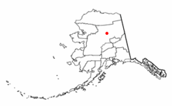
AKMap-doton-StevensVillage.PNG
Location of Stevens Village, Alaska
Coordinates: 66°0′19″N149°6′11″W / 66.00528°N 149.10306°W / 66.00528; -149.10306
CountryUnited States
State Alaska
Census Area Yukon-Koyukuk
Government
   State senator Click Bishop (R)
   State rep. Mike Cronk (R)
Area
[1]
  Total13.29 sq mi (34.43 km2)
  Land11.65 sq mi (30.17 km2)
  Water1.64 sq mi (4.25 km2)
Population
 (2020)
  Total37
  Density3.18/sq mi (1.23/km2)
Time zone UTC-9 (Alaska (AKST))
  Summer (DST) UTC-8 (AKDT)
ZIP code
99774
Area code 907
FIPS code 02-73290

Stevens Village (Denyeet in Koyukon) is a census-designated place (CDP) in Yukon-Koyukuk Census Area, Alaska, United States. The population was 78 at the 2010 census, down from 87 in 2000.

Contents

The village is named for its first chief, Skidedlestalk “Old Steven” Stevens (1850-d. 1912~1920). [2] [3]

Geography

Stevens Village is located at 66°0′19″N149°6′11″W / 66.00528°N 149.10306°W / 66.00528; -149.10306 (66.005296, -149.103032), [4] in the middle of the Yukon Flats.

According to the United States Census Bureau, the CDP has a total area of 11.0 square miles (28 km2), of which, 10.4 square miles (27 km2) of it is land and 0.6 square miles (1.6 km2) of it (5.47%) is water.

Demographics

Historical population
CensusPop.Note
1910 100
1920 1033.0%
1930 48−53.4%
1940 5412.5%
1950 8455.6%
1960 10221.4%
1970 74−27.5%
1980 9629.7%
1990 1026.3%
2000 87−14.7%
2010 78−10.3%
2020 37−52.6%
U.S. Decennial Census [5]

Stevens Village originally had been “Stevens Camp,” and was so listed in the 1900 Census. [6] It next appeared on the 1910 U.S. Census as the unincorporated village of Stevens. It returned again in 1920, and in 1930, it returned as "Stephens." From 1940–60, it returned again as "Stevens." In 1970, and in every successive census, it has returned as Stevens Village. It was made a census-designated place (CDP) in 1980.

As of the census [7] of 2000, there were 87 people, 35 households, and 15 families residing in the CDP. The population density was 8.4 inhabitants per square mile (3.2/km2). There were 43 housing units at an average density of 4.1 per square mile (1.6/km2). The racial makeup of the CDP was 3.45% White, 95.40% Native American, 1.15% from other races. 6.90% of the population were Hispanic or Latino of any race.

There were 35 households, out of which 28.6% had children under the age of 18 living with them, 2.9% were married couples living together, 31.4% had a female householder with no husband present, and 54.3% were non-families. 45.7% of all households were made up of individuals, and 11.4% had someone living alone who was 65 years of age or older. The average household size was 2.49 and the average family size was 3.63.

In the CDP, the age distribution of the population shows 29.9% under the age of 18, 8.0% from 18 to 24, 31.0% from 25 to 44, 24.1% from 45 to 64, and 6.9% who were 65 years of age or older. The median age was 35 years. For every 100 females, there were 190.0 males. For every 100 females age 18 and over, there were 190.5 males.

The median income for a household in the CDP was $12,500, and the median income for a family was $11,563. Males had a median income of $11,250 versus $0 for females. The per capita income for the CDP was $7,113. There were 60.0% of families and 61.2% of the population living below the poverty line, including 70.8% of under eighteens and 25.0% of those over 64.

Related Research Articles

<span class="mw-page-title-main">College, Alaska</span> Census-designated place in Alaska, United States

College is a census-designated place (CDP) in Fairbanks North Star Borough, Alaska, United States. It is part of the Fairbanks, Alaska Metropolitan Statistical Area. As of the 2020 census, the population was 11,332, down from 12,964 in 2010. College is the third-most populated CDP in Alaska.

<span class="mw-page-title-main">Gateway, Alaska</span> CDP in Alaska, United States

Gateway is a census-designated place (CDP) in Matanuska-Susitna Borough, Alaska, United States. It is part of the Anchorage, Alaska Metropolitan Statistical Area. The population was 5,748 at the 2020 census, up from 5,552 in 2010. Gateway is the fifth-most populated CDP in the borough.

<span class="mw-page-title-main">Alcan Border, Alaska</span> Census-designated place in Alaska, United States

Alcan Border, also known as Port Alcan, is a census-designated place in the Southeast Fairbanks Census Area in the U.S. state of Alaska. Part of the Unorganized Borough, Alcan Border is the site of the Alcan - Beaver Creek Border Crossing, the main U.S. port of entry for persons arriving in Alaska by road. The population was 33 at the 2010 census, up from 21 in 2000.

<span class="mw-page-title-main">Eagle Village, Alaska</span> CDP in Alaska, United States

Eagle Village is a census-designated place (CDP) in Southeast Fairbanks Census Area, Alaska, United States. The population was 67 at the 2010 census.

<span class="mw-page-title-main">Tetlin, Alaska</span> CDP in Alaska, United States

Tetlin is a census-designated place (CDP) in Southeast Fairbanks Census Area, Alaska, United States. At the 2010 census the population was 127, up from 117 in 2000.

<span class="mw-page-title-main">Mentasta Lake, Alaska</span> CDP in Alaska, United States

Mentasta Lake is a census-designated place (CDP) in Copper River Census Area, Alaska, United States. At the 2010 census the population was 112, down from 142 in 2000.

<span class="mw-page-title-main">Arctic Village, Alaska</span> CDP in Alaska, United States

Arctic Village is an unincorporated Native American village and a census-designated place (CDP) in Yukon-Koyukuk Census Area, Alaska, United States. As of the 2010 census, the population of the CDP was 152. This was unchanged from 2000. The village is located in the large Gwitch'in speaking region of Alaska, and the local dialect is known as Di'haii Gwitch'in or shahanh. As of 1999, over 95% of the community speaks and understands the language. As of 2019, the second village chief was against oil drilling because of the impact on caribou.

<span class="mw-page-title-main">Beaver, Alaska</span> CDP in Alaska, United States

Beaver is a census-designated place (CDP) in Yukon-Koyukuk Census Area, Alaska, United States. At the time of the 2010 census the population was 84, unchanged from 2000, however the 2020 census reported a total population of 48.

Birch Creek is a census-designated place (CDP) in Yukon-Koyukuk Census Area, Alaska, United States. The population was 33 at the 2010 census, up from 28 in 2000.

<span class="mw-page-title-main">Central, Alaska</span> CDP in Alaska, United States

Central is a census-designated place (CDP) in Yukon-Koyukuk Census Area, Alaska, United States. At the 2010 census the population was 96, down from 134 in 2000. Every February, Central hosts a checkpoint for the long-distance Yukon Quest sled dog race.

<span class="mw-page-title-main">Chalkyitsik, Alaska</span> CDP in Alaska, United States

Chalkyitsik, meaning "to fish with a hook, at the mouth of the creek", is a census-designated place (CDP) in Yukon-Koyukuk Census Area, Alaska, United States. It is located on the left (south) bank of the Black River, 45 miles northeast of Fort Yukon. At the 2010 census the population was 69, down from 83 in 2000.

<span class="mw-page-title-main">Circle, Alaska</span> CDP in Alaska, United States

Circle is a census-designated place (CDP) in Yukon-Koyukuk Census Area, Alaska, United States. At the 2010 census the population was 104, up from 100 in 2000.

Four Mile Road is a census-designated place (CDP) in Yukon-Koyukuk Census Area, Alaska, United States. The population was 43 at the 2010 census, up from 38 in 2000.

<span class="mw-page-title-main">Lake Minchumina, Alaska</span> CDP in Alaska, United States

Lake Minchumina is a census-designated place (CDP) in Yukon-Koyukuk Census Area, Alaska, United States. As of the 2020 census, the population of the CDP is 30.

<span class="mw-page-title-main">Livengood, Alaska</span> CDP in Alaska, United States

Livengood is a census-designated place (CDP) in Yukon-Koyukuk Census Area, Alaska, United States. The population was 16 at the 2020 census, compared to 13 in 2010 and 29 in 2000.

Minto is a census-designated place (CDP) in Yukon-Koyukuk Census Area, Alaska, United States. As of the 2020 census, the population of the CDP is 150, down from 210 in 2010. The name is an anglicized version of the Lower Tanana Athabaskan name Menhti, meaning 'among the lakes'. After repeated flooding the village was relocated to its present location in 1969. The former village site is now known as Old Minto.

<span class="mw-page-title-main">New Allakaket, Alaska</span> CDP in Alaska, United States

New Allakaket was a census-designated place (CDP) in Yukon-Koyukuk Census Area, Alaska, United States. The population was 66 at the 2010 census, up from 36 in 2000. In March 2015, neighboring Allakaket annexed New Allakaket.

<span class="mw-page-title-main">Rampart, Alaska</span> CDP in Alaska, United States

Rampart is a census-designated place (CDP) in Yukon-Koyukuk Census Area, Alaska, United States. The population was 24 at the 2010 census, down from 45 in 2000.

<span class="mw-page-title-main">Wiseman, Alaska</span> CDP in Alaska, United States

Wiseman is a census-designated place (CDP) in Yukon-Koyukuk Census Area, Alaska, United States. The full time resident population is 12 as of 2022.

Amelia is a census-designated place (CDP) in St. Mary Parish, Louisiana, United States. The population was 2,459 at the 2010 census. It is part of the Morgan City Micropolitan Statistical Area.

References

  1. "2020 U.S. Gazetteer Files". United States Census Bureau. Retrieved October 29, 2021.
  2. Orth, Donald J. (1967). Dictionary of Alaska Place Names. U.S. Government Printing Office.; Phillips, James W. (1973). Alaska-Yukon Place Names. University of Washington Press. ISBN   0-295-95259-8.
  3. 13th Census of the United States, Census of Alaska, 4th District, Stevens Village (December 25-26, 1909). Retrieved February 23, 2019.
  4. "US Gazetteer files: 2010, 2000, and 1990". United States Census Bureau. February 12, 2011. Retrieved April 23, 2011.
  5. "U.S. Decennial Census". Census.gov. Retrieved June 6, 2013.
  6. 12th Census of the United States, Census of Alaska, Northern District, Stevens Camp near Dall River (April 12-13, 1900). Retrieved February 16, 2019.
  7. "U.S. Census website". United States Census Bureau . Retrieved January 31, 2008.

Commons-logo.svg Media related to Yukon Flats National Wildlife Refuge at Wikimedia Commons