
Yukon–Koyukuk Census Area is a census area in the U.S. state of Alaska. As of the 2010 census, the population was 5,588. It has the largest area of any county or county-equivalent in the United States. It is part of the unorganized borough of Alaska and therefore has no borough seat. Its largest communities are the cities of Galena, in the west, and Fort Yukon, in the northeast.
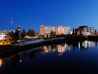
Fairbanks is a home rule city and the borough seat of the Fairbanks North Star Borough in the U.S. state of Alaska.

North Pole is a small city in the Fairbanks North Star Borough, Alaska, United States. It is part of the Fairbanks metropolitan statistical area. As of the 2010 United States Census, the city had a population of 2,117, up from 1,570 in 2000. Despite its name, the city is about 1,700 miles (2,700 km) south of Earth's geographic North Pole and 125 miles (200 km) south of the Arctic Circle.

Big Delta is a census-designated place (CDP) in Southeast Fairbanks Census Area, Alaska, United States. The population was 591 at the 2010 census, down from 749 in 2000. Big Delta is at the confluence of the Delta River and the Tanana River and gets its name from the huge river delta formed by the confluence.

Delta Junction is a city in the Southeast Fairbanks Census Area, Alaska, United States. As of the 2010 census, the population was 958, up from 840 in 2000. The 2018 estimate was down to 931. The city is located a short distance south of the confluence of the Delta River with the Tanana River, which is at Big Delta. It is about 160 km (99 mi) south of Fairbanks. Native inhabitants are Tanana Athabaskans.
Tetlin is a census-designated place (CDP) in Southeast Fairbanks Census Area, Alaska, United States. At the 2010 census the population was 127, up from 117 in 2000.
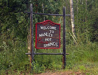
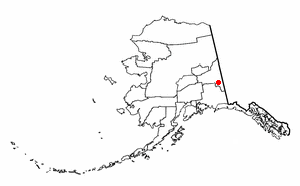
Manley Hot Springs is a census-designated place (CDP) in Yukon-Koyukuk Census Area, Alaska, United States. At the 2010 census the population was 89, up from 72 in 2000.

Minto is a census-designated place (CDP) in Yukon-Koyukuk Census Area, Alaska, United States. As of the 2010 census, the population of the CDP is 210, down from 258 in 2000. The name is an anglicized version of the Lower Tanana Athabaskan name Menhti, meaning 'among the lakes'. After repeated flooding the village was relocated to its present location in 1969. The former village site is now known as Old Minto.

Nenana is a home rule city in the Yukon-Koyukuk Census Area of the Unorganized Borough in the Interior of the U.S. state of Alaska. Nenana developed as a Lower Tanana community at the confluence where the tributary Nenana River enters the Tanana. The population was 378 at the 2010 census, down from 402 in 2000.

Tanana is a city in the Yukon-Koyukuk Census Area in the U.S. state of Alaska. At the 2010 census the population was 246, down from 308 in 2000. It was formerly known as Clachotin, adopted by Canadian French.
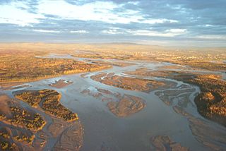
The Tanana River is a 584-mile (940 km) tributary of the Yukon River in the U.S. state of Alaska. According to linguist and anthropologist William Bright, the name is from the Koyukon (Athabaskan) tene no, tenene, literally "trail river".
The Tanana Valley is a lowland region in central Alaska in the United States, on the north side of the Alaska Range where the Tanana River emerges from the mountains. Traditional inhabitants of the valley are Tanana Athabaskans of Alaskan Athabaskans.

The Nenana River is a tributary of the Tanana River, approximately 140 miles (230 km) long, in central Alaska in the United States. It drains an area on the north slope of the Alaska Range on the south edge of the Tanana Valley southwest of Fairbanks.

The Elliott Highway is a highway in the U.S. state of Alaska that extends 152 miles (245 km) from Fox, about 10 miles (16 km) north of Fairbanks, to Manley Hot Springs. It was completed in 1959 and is part of Alaska Route 2.
A Bering Strait crossing is a hypothetical bridge or tunnel spanning the relatively narrow and shallow Bering Strait between the Chukotka Peninsula in Russia and the Seward Peninsula in the U.S. state of Alaska. The crossing would provide a connection linking North America and Eurasia.
Manley Hot Springs Airport is a state owned, public use airport located in Manley Hot Springs, in the Yukon-Koyukuk Census Area of the U.S. state of Alaska. Scheduled passenger service at this airport is subsidized by the U.S. Department of Transportation via the Essential Air Service program.
Minto Al Wright Airport is a state-owned public-use airport located one nautical mile (2 km) east of the central business district of Minto, in the Yukon-Koyukuk Census Area of the U.S. state of Alaska. Formerly known as Minto Airport, it was renamed in August 2009 to honor Al Wright, an Alaskan aviation pioneer and founder of Wright Air Service. Scheduled commercial airline service is subsidized by the Essential Air Service program.

Alaska Route 2 is a state highway in the central and east-central portions of the U.S. state of Alaska. It runs from Manley Hot Springs to the International Border, passing through Fairbanks and Delta Junction. Alaska Route 2 includes the entire length of the Alaska Highway in the state, the remainder of the highway being in the Yukon Territory and British Columbia, Canada.

Michael Alan Silka was an American spree killer who is believed to have murdered nine people in Alaska during May 1984, primarily in the small village of Manley Hot Springs. The spree culminated in a shootout with Alaska State Troopers in the Alaskan wilderness in which Silka was shot and killed. The motives for Silka's actions remain unclear.
Hutlinana is a geothermal spring located on the Hutlinana River, east of the Elliott Highway in interior Alaska, approximately 150 miles northwest of Fairbanks. There is no direct road access. The trail is used primarily in winter after freeze-up.

