
Canada has a vast geography that occupies much of the continent of North America, sharing a land border with the contiguous United States to the south and the U.S. state of Alaska to the northwest. Canada stretches from the Atlantic Ocean in the east to the Pacific Ocean in the west; to the north lies the Arctic Ocean. Greenland is to the northeast with a shared border on Hans Island. To the southeast Canada shares a maritime boundary with France's overseas collectivity of Saint Pierre and Miquelon, the last vestige of New France. By total area, Canada is the second-largest country in the world, after Russia. By land area alone, however, Canada ranks fourth, the difference being due to it having the world's largest proportion of fresh water lakes. Of Canada's thirteen provinces and territories, only two are landlocked while the other eleven all directly border one of three oceans.

The Canadian Shield, also called the Laurentian Shield or the Laurentian Plateau, is a geologic shield, a large area of exposed Precambrian igneous and high-grade metamorphic rocks. It forms the North American Craton, the ancient geologic core of the North American continent. Glaciation has left the area with only a thin layer of soil, through which exposures of igneous bedrock resulting from its long volcanic history are frequently visible. As a deep, common, joined bedrock region in eastern and central Canada, the shield stretches north from the Great Lakes to the Arctic Ocean, covering over half of Canada and most of Greenland; it also extends south into the northern reaches of the continental United States.

Ellesmere Island is Canada's northernmost and third largest island, and the tenth largest in the world. It comprises an area of 196,236 km2 (75,767 sq mi), slightly smaller than Great Britain, and the total length of the island is 830 km (520 mi).

The Appalachian Mountains, often called the Appalachians, are a mountain range in eastern to northeastern North America. The term "Appalachian" refers to several different regions associated with the mountain range, and its surrounding terrain. The general definition used is one followed by the United States Geological Survey and the Geological Survey of Canada to describe the respective countries' physiographic regions. The U.S. uses the term Appalachian Highlands and Canada uses the term Appalachian Uplands; the Appalachian Mountains are not synonymous with the Appalachian Plateau, which is one of the provinces of the Appalachian Highlands.

The Queen Elizabeth Islands are the northernmost cluster of islands in Canada's Arctic Archipelago, split between Nunavut and the Northwest Territories in Northern Canada. The Queen Elizabeth Islands contain approximately 14% of the global glacier and ice cap area. The southern islands are called the Parry Islands or Parry Archipelago.

Axel Heiberg Island is an uninhabited island in the Qikiqtaaluk Region, Nunavut, Canada. Located in the Arctic Ocean, it is the 32nd largest island in the world and Canada's seventh largest island. According to Statistics Canada, it has an area of 43,178 km2 (16,671 sq mi). It is named after Axel Heiberg.
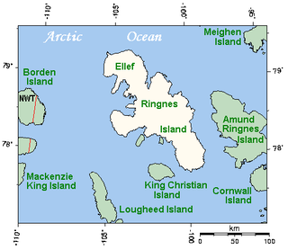
Ellef Ringnes Island is an uninhabited island and one of the Sverdrup Islands in the Qikiqtaaluk Region, Nunavut, Canada. A member of the Queen Elizabeth Islands and Arctic Archipelago, it is located in the Arctic Ocean, east of Borden Island, and west of Amund Ringnes Island. It has an area of 11,295 km2 (4,361 sq mi), making it the 69th largest island in the world and Canada's 16th largest island. Its highest mount is 260 m (850 ft).

The Innuitian Mountains are a mountain range in Nunavut and the Northwest Territories, Canada. They are part of the Arctic Cordillera and are largely unexplored, due to the hostile climate. They are named after the northern indigenous people, the Inuit. In some locations the Innuitian Mountains measure over 2,500 m (8,202 ft) in height, and 1,290 km (802 mi) in length. The highest point is Barbeau Peak on Ellesmere Island at 2,616 m (8,583 ft). There are no trees and minimal wildlife in the Innuitian Mountains due to the harsh cold climate as well as being located north of the Arctic tree line. This region is mostly barren with vast areas of permafrost. There are metallic mineral resources including iron and zinc and fossil fuel resources such as coal.
The Arctic Lands is a physiographic region located in northern Canada. It is one of Canada's seven physiographic regions, which is divided into three divisions—the Innuitian Region, Arctic Coastal Plain, and Arctic Lowlands.

The Arctic Cordillera is a terrestrial ecozone in northern Canada characterized by a vast, deeply dissected chain of mountain ranges extending along the northeastern flank of the Canadian Arctic Archipelago from Ellesmere Island to the northeasternmost part of the Labrador Peninsula in northern Labrador and northern Quebec, Canada. It spans most of the eastern coast of Nunavut with high glaciated peaks rising through ice fields and some of Canada's largest ice caps, including the Penny Ice Cap on Baffin Island. It is bounded to the east by Baffin Bay, Davis Strait and the Labrador Sea while its northern portion is bounded by the Arctic Ocean.
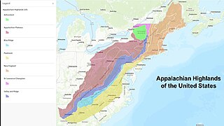
The Appalachian Highlands is one of eight government-defined physiographic divisions of the contiguous United States. The links with the Appalachian Uplands in Canada to make up the Appalachian Mountains. The Highlands includes seven physiographic provinces, which is the second level in the physiographic classification system in the United States. At the next level of physiographic classification, called section/subsection, there are 20 unique land areas with one of the provinces having no sections.
The Great Lakes-St. Lawrence Lowlands, or simply St. Lawrence Lowlands, is a physiographic region of Eastern Canada that comprises a section of southern Ontario bounded on the north by the Canadian Shield and by three of the Great Lakes — Lake Huron, Lake Erie and Lake Ontario — and extends along the St. Lawrence River to the Strait of Belle Isle and the Atlantic Ocean. The lowlands comprise three sub-regions that were created by intrusions from adjacent physiographic regions — the West Lowland, Central Lowland and East Lowland. The West Lowland includes the Niagara Escarpment, extending from the Niagara River to the Bruce Peninsula and Manitoulin Island. The Central Lowland stretches between the Ottawa River and the St. Lawrence River. The East Lowland includes Anticosti Island, Îles de Mingan, and extends to the Strait of Belle Isle.

The Alpha Ridge is a major volcanic ridge under the Arctic Ocean between the Canada Basin and the Lomonosov Ridge. It was active during the formation of the Amerasian Basin. It was discovered in 1963. The highest elevation is about 2,700 m over the ocean floor. It is 200 to 450 km wide. The Alpha Ridge, Lomonosov Ridge, and Nansen-Gakkel Ridge are the three major ranges that divide the Arctic Ocean floor, running generally parallel to each other.

The Laurentian Upland is a physiographic region which, when referred to as the "Laurentian Region" or the Grenville geological province, is recognized by Natural Resources Canada as one of five provinces of the larger Canadian Shield physiographic division. The United States Geological Survey recognizes the Laurentian Upland as the larger general upland area of the Canadian Shield.
Hoved Island is part of the Qikiqtaaluk Region of the Canadian territory of Nunavut. The island is located between the Svendsen and Bjorne peninsulas, and within the Baumann Fiord of Ellesmere Island, considered part of the Queen Elizabeth Islands, in the Arctic Archipelago. It comprises an area of 158 km2 (61 sq mi).
The Kazan Region is a physiographic province of Canada and the part of the Canadian Shield that is located in extreme northeastern Alberta, northern Manitoba, and Saskatchewan, and also in parts of the Northwest Territories and Nunavut.

The Canadian Arctic tundra is a biogeographic designation for Northern Canada's terrain generally lying north of the tree line or boreal forest, that corresponds with the Scandinavian Alpine tundra to the east and the Siberian Arctic tundra to the west inside the circumpolar tundra belt of the Northern Hemisphere.
The Eurekan orogeny was a Phanerozoic mountain building event that affected the eastern portion of the Arctic Archipelago and, to a lesser extent, northern Greenland. Deformation initiated in the Late Cretaceous, during which time the Sverdrup Basin began to fragment and fold in response to the counterclockwise rotation of Greenland, caused by seafloor spreading in the Canadian Arctic Rift System. Isostatic uplift was most pronounced in the Grantland Mountains and Victoria and Albert Mountains on Ellesmere Island and in the Princess Margaret Range on Axel Heiberg Island, as evidenced by the current physiography. Compression in a broad zone on Ellesmere Island resulted in the formation of the Eurekan Fold Belt.
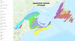
The Appalachian Uplands is one of the seven physiographic regions in Canada, distinguished by its topography and geology. The region includes southern Quebec, Gaspésie, New Brunswick, Nova Scotia, Prince Edward Island and the island of Newfoundland. This is the Canadian portion of the Appalachian Mountains. The United States equivalent portion is called the Appalachian Highlands.

