Quantitative geography

Last updated

Quantitative geography is a subfield and methodological approach to geography that develops, tests, and uses scientific, mathematical, and statistical methods to analyze and model geographic phenomena and patterns. [1] [2] [3] It aims to explain and predict the distribution and dynamics of human and physical geography through the collection and analysis of quantifiable data. [4] The approach quantitative geographers take is generally in line with the scientific method, where a falsifiable hypothesis is generated, and then tested through observational studies. [3] [5] [6] [7] This has received criticism, and in recent years, quantitative geography has moved to include systematic model creation and understanding the limits of their models. [6] [8] [9] This approach is used to study a wide range of topics, including population demographics, urbanization, environmental patterns, and the spatial distribution of economic activity. [1] The methods of quantitative geography are often contrasted by those employed by qualitative geography, which is more focused on observing and recording characteristics of geographic place. However, there is increasing interest in using combinations of both qualitative and quantitative methods through mixed-methods research to better understand and contextualize geographic phenomena. [10]

Contents

History

Quantitative geography emerged in the mid-20th century as a response to the increasing demand for more systematic, empirical, and data-driven approaches to studying geographic phenomena. [6] It is a direct product of the quantitative revolution in geography. [1] [11]

It was influenced by developments in statistics, mathematics, computer science, and the physical sciences. [12] Quantitative geographers sought to use mathematical and statistical methods to better understand patterns, relationships, and processes in the spatial distribution of human and physical phenomena.

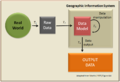
Computers perhaps had the most profound impact on quantitative geography, with techniques such as map analysis, regression analysis, and spatial statistics to investigate various geographic questions. [1] In the 1950s and 1960s, advances in computer technology facilitated the application of quantitative methods in geography, leading to new techniques such as geographic information systems (GIS). [13] [14] Notable early pioneers in GIS are Roger Tomlinson and Waldo Tobler. [12] Simultaneously, new data sources, such as remote sensing and GPS, were incorporated into geographic research. [15] [16] These tools enabled geographers to collect, analyze, and visualize large amounts of spatial data in new ways, further advancing the field of quantitative geography. [1]

In the late 20th century, quantitative geography became a central discipline within geography, and its influence was felt in fields such as urban, economic, and environmental geography. [1] Within academia, groups such as the Royal Geographical Society Study Group in Quantitative Methods focused on spreading these methods to students and the public through publications such as the Concepts and Techniques in Modern Geography series. [17] [18] Economics and spatial econometrics both served as a driving force and area of application for quantitative geography. [19]

Today, research in quantitative geography continues, focusing on using innovative quantitative methods and technologies to address complex geographic questions and problems.

Techniques and subfields

Quantitative revolution

The quantitative revolution (QR) [lower-alpha 1] was a paradigm shift that sought to develop a more rigorous and systematic methodology for the discipline of geography. It came as a response to the inadequacy of regional geography to explain general spatial dynamics. The main claim for the quantitative revolution is that it led to a shift from a descriptive (idiographic) geography to an empirical law-making (nomothetic) geography. [20] [21] The quantitative revolution occurred during the 1950s and 1960s and marked a rapid change in the method behind geographical research, from regional geography into a spatial science. [22] [23]

Laws of geography

Waldo Tobler in front of the Newberry Library. Chicago, November 2007 Waldo Tobler 2007.jpg
Waldo Tobler in front of the Newberry Library. Chicago, November 2007

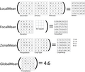
The concept of laws in geography is a product of the quantitative revolution and is a central focus of quantitative geography. [24] Their emergence is highly influential and one of the major contributions of quantitative geography to the broader branch of technical geography. [25] The discipline of geography is unlikely to settle the matter anytime soon. Several laws have been proposed, and Tobler's first law of geography is the most widely accepted. The first law of geography, and its relation to spatial autocorrelation, is highly influential in the development of technical geography. [25]

Some have argued that geographic laws do not need to be numbered. The existence of a first invites a second, and many are proposed as that. It has also been proposed that Tobler's first law of geography should be moved to the second and replaced with another. [26] A few of the proposed laws of geography are below:

Criticism

Critical geography presents critiques against the approach adopted in quantitative geography, sometimes labeled by the critics as a "positivist" approach particularly in relation to the so-called "quantitative revolution" of the 1960s. One of the primary criticisms is reductionism, contending that the emphasis on quantifying data and utilizing mathematical models tends to oversimplify the intricate nature of social and spatial phenomena. [3] Critics also argue that quantitative methods may disregard the unique cultural and historical contexts of specific geographical locations. Critics have likewise argued that reliance on digital mapping tools and technology can restrict the capacity to address certain complex geographical issues, and claim that quantitative data collection methods can introduce partiality into the analysis, for example existing power structures can influence quantitative research by shaping the types of data collected and analyzed.

Quantitative geography has been criticized as being limited in scope in that spatial data may not adequately capture certain dimensions of cultural, political, and social relations in human geographies. Lastly, critics emphasize the absence of a critical perspective within this approach, arguing that the unwavering focus on objective and empirical data analysis can divert attention from vital social and political questions, hindering a holistic understanding of geographical issues. The critics argue that these criticisms collectively suggest the need for a more nuanced and context-aware approach in the field of geography.

Quantitative geographers have responded to the criticisms to various degrees, including that the broad brush of the critiques, along with associated labeling, are misplaced:

"Quantitative geographers do not often concern themselves with philosophy, and although externally we are often labelled (incorrectly in many cases) as positivists, such a label has little or zero impact on the way in which we prosecute research. We do not, for example, concern ourselves with whether our intended research strategy breaches some tenet of positivist philosophy. Indeed, most of us would have scant knowledge of what such tenets are. As Barnes (2001) observes, for many of us, our first experience with positivism occurs when it is directed at us as a form of criticism." [30]

Influential geographers

See also

Notes

    1. During the 1940s–1970s, it was customary to capitalize generalized concept names, especially in philosophy ("Truth, Kindness, Beauty"), plus using capital letters when naming ideologies, movements, or schools of thought. Example: "the Automobile" as a concept, versus "the automobile in a garage"

    Related Research Articles

    <span class="mw-page-title-main">Human geography</span> Study of cultures, communities, and activities of peoples of the world

    Human geography or anthropogeography is the branch of geography which studies spatial relationships between human communities, cultures, economies, and their interactions with the environment, examples of which include urban sprawl and urban redevelopment. It analyzes spatial interdependencies between social interactions and the environment through qualitative and quantitative methods.This multidisciplinary approach draws from sociology, anthropology, economics, and environmental science, contributing to a comprehensive understanding of the intricate connections that shape lived spaces.

    <span class="mw-page-title-main">Economic geography</span> Subfield of human geography and economics

    Economic geography is the subfield of human geography that studies economic activity and factors affecting it. It can also be considered a subfield or method in economics. There are four branches of economic geography.

    <span class="mw-page-title-main">Waldo R. Tobler</span> American geographer

    Waldo Rudolph Tobler was an American-Swiss geographer and cartographer. Tobler is regarded as one of the most influential geographers and cartographers of the late 20th century and early 21st century. He is most well known for coining what has come to be referred to as Tobler's first law of geography. He also coined what has come to be referred to as Tobler's second law of geography.

    <span class="mw-page-title-main">Michael Frank Goodchild</span> British-American geographer

    Michael Frank Goodchild is a British-American geographer. He is an Emeritus Professor of Geography at the University of California, Santa Barbara. After nineteen years at the University of Western Ontario, including three years as chair, he moved to Santa Barbara in 1988, as part of the establishment of the National Center for Geographic Information and Analysis, which he directed for over 20 years. In 2008, he founded the UCSB Center for Spatial Studies.

    <span class="mw-page-title-main">Tobler's first law of geography</span> The first of several proposed laws of geography

    The First Law of Geography, according to Waldo Tobler, is "everything is related to everything else, but near things are more related than distant things." This first law is the foundation of the fundamental concepts of spatial dependence and spatial autocorrelation and is utilized specifically for the inverse distance weighting method for spatial interpolation and to support the regionalized variable theory for kriging. The first law of geography is the fundamental assumption used in all spatial analysis.

    The quantitative revolution (QR) was a paradigm shift that sought to develop a more rigorous and systematic methodology for the discipline of geography. It came as a response to the inadequacy of regional geography to explain general spatial dynamics. The main claim for the quantitative revolution is that it led to a shift from a descriptive (idiographic) geography to an empirical law-making (nomothetic) geography. The quantitative revolution occurred during the 1950s and 1960s and marked a rapid change in the method behind geographical research, from regional geography into a spatial science.

    <span class="mw-page-title-main">Spatial analysis</span> Formal techniques which study entities using their topological, geometric, or geographic properties

    Spatial analysis is any of the formal techniques which studies entities using their topological, geometric, or geographic properties. Spatial analysis includes a variety of techniques using different analytic approaches, especially spatial statistics. It may be applied in fields as diverse as astronomy, with its studies of the placement of galaxies in the cosmos, or to chip fabrication engineering, with its use of "place and route" algorithms to build complex wiring structures. In a more restricted sense, spatial analysis is geospatial analysis, the technique applied to structures at the human scale, most notably in the analysis of geographic data. It may also be applied to genomics, as in transcriptomics data.

    <span class="mw-page-title-main">Field (geography)</span> Property that varies over space

    In the context of spatial analysis, geographic information systems, and geographic information science, a field is a property that fills space, and varies over space, such as temperature or density. This use of the term has been adopted from physics and mathematics, due to their similarity to physical fields (vector or scalar) such as the electromagnetic field or gravitational field. Synonymous terms include spatially dependent variable (geostatistics), statistical surface ( thematic mapping), and intensive property (physics and chemistry) and crossbreeding between these disciplines is common. The simplest formal model for a field is the function, which yields a single value given a point in space (i.e., t = f(x, y, z) )

    <span class="mw-page-title-main">Spatial heterogeneity</span>

    Spatial heterogeneity is a property generally ascribed to a landscape or to a population. It refers to the uneven distribution of various concentrations of each species within an area. A landscape with spatial heterogeneity has a mix of concentrations of multiple species of plants or animals (biological), or of terrain formations (geological), or environmental characteristics filling its area. A population showing spatial heterogeneity is one where various concentrations of individuals of this species are unevenly distributed across an area; nearly synonymous with "patchily distributed."

    <span class="mw-page-title-main">Geography</span> Study of lands and inhabitants of Earth

    Geography is the study of the lands, features, inhabitants, and phenomena of Earth. Geography is an all-encompassing discipline that seeks an understanding of Earth and its human and natural complexities—not merely where objects are, but also how they have changed and come to be. While geography is specific to Earth, many concepts can be applied more broadly to other celestial bodies in the field of planetary science. Geography has been called "a bridge between natural science and social science disciplines."

    <span class="mw-page-title-main">Tobler's second law of geography</span> One of several proposed laws of geography

    The second law of geography, according to Waldo Tobler, is "the phenomenon external to a geographic area of interest affects what goes on inside." This is an extension of his first. He first published it in 1999 in reply to a paper titled "Linear pycnophylactic reallocation comment on a paper by D. Martin" and then again in response to criticism of his first law of geography titled "On the First Law of Geography: A Reply." Much of this criticism was centered on the question of if laws were meaningful in geography or any of the social sciences. In this document, Tobler proposed his second law while recognizing others have proposed other concepts to fill the role of 2nd law. Tobler asserted that this phenomenon is common enough to warrant the title of 2nd law of geography. Unlike Tobler's first law of geography, which is relatively well accepted among geographers, there are a few contenders for the title of the second law of geography. Tobler's second law of geography is less well known but still has profound implications for geography and spatial analysis.

    <span class="mw-page-title-main">Arbia's law of geography</span> One of several proposed laws of geography

    Arbia’s law of geography states, "Everything is related to everything else, but things observed at a coarse spatial resolution are more related than things observed at a finer resolution." Originally proposed as the 2nd law of geography, this is one of several laws competing for that title. Because of this, Arbia's law is sometimes referred to as the second law of geography, or Arbia's second law of geography.

    <span class="mw-page-title-main">Technical geography</span> Study of using and creating tools to manage spatial information

    Technical geography is the branch of geography that involves using, studying, and creating tools to obtain, analyze, interpret, understand, and communicate spatial information.

    <span class="mw-page-title-main">Uncertain geographic context problem</span> Source of statistical bias

    The uncertain geographic context problem or UGCoP is a source of statistical bias that can significantly impact the results of spatial analysis when dealing with aggregate data. The UGCoP is very closely related to the Modifiable areal unit problem (MAUP), and like the MAUP, arises from how we divide the land into areal units. It is caused by the difficulty, or impossibility, of understanding how phenomena under investigation in different enumeration units interact between enumeration units, and outside of a study area over time. It is particularly important to consider the UGCoP within the discipline of time geography, where phenomena under investigation can move between spatial enumeration units during the study period. Examples of research that needs to consider the UGCoP include food access and human mobility.

    <span class="mw-page-title-main">Qualitative geography</span> Subfield of geographic methods

    Qualitative geography is a subfield and methodological approach to geography focusing on nominal data, descriptive information, and the subjective and interpretive aspects of how humans experience and perceive the world. Often, it is concerned with understanding the lived experiences of individuals and groups and the social, cultural, and political contexts in which those experiences occur. Thus, qualitative geography is traditionally placed under the branch of human geography; however, technical geographers are increasingly directing their methods toward interpreting, visualizing, and understanding qualitative datasets, and physical geographers employ nominal qualitative data as well as quanitative. Furthermore, there is increased interest in applying approaches and methods that are generally viewed as more qualitative in nature to physical geography, such as in critical physical geography. While qualitative geography is often viewed as the opposite of quantitative geography, the two sets of techniques are increasingly used to complement each other. Qualitative research can be employed in the scientific process to start the observation process, determine variables to include in research, validate results, and contextualize the results of quantitative research through mixed-methods approaches.

    George Frederick Jenks (1916–1996) was an American geographer known for his significant contributions to cartography and geographic information systems (GIS). With a career spanning over three decades, Jenks played a vital role in advancing map-making technologies, was instrumental in enhancing the visualization of spatial data, and played foundational roles in developing modern cartographic curricula. The Jenks natural breaks optimization, based on his work, is still widely used in the creation of thematic maps, such as choropleth maps.

    Arthur Getis was an American geographer known for his significant contributions to spatial statistics and geographic information science (GIScience). With a career spanning over four decades, Getis authored more than one hundred peer-reviewed papers and book chapters, greatly influencing GIScience and geography as a whole. The Getis-Ord family of statistics, one of the most commonly used in spatial analysis, is based on his and J. Keith Ord's work and is still widely used in the creation of hot spot maps.

    Alexander Stewart Fotheringham is a British-American geographer known for his contributions to quantitative geography and geographic information science (GIScience). He holds a Ph.D. in geography from McMaster University and is a Regents professor of computational spatial science in the School of Geographical Sciences and Urban Planning at Arizona State University. He has contributed to the literature surrounding spatial analysis and spatial statistics, particularly in the development of geographically weighted regression (GWR) and multiscale geographically weighted regression (MGWR).

    Duane Francis Marble was an American geographer known for his significant contributions to quantitative geography and geographic information science (GIScience). Marble had a 40-year career as a professor at multiple institutions, retiring from the Ohio State University and holding a courtesy appointment as Professor of Geosciences at Oregon State University afterward. His early work was highly influential in computer cartography and is regarded as a significant contributor to the quantitative revolution in geography. His work on constructing a "Model Curricula" in GIScience is listed as the starting foundation built upon by the Geographic Information Science and Technology Body of Knowledge.

    <span class="mw-page-title-main">Waldo Tobler bibliography</span> Geographer Waldo Toblers publications

    Waldo Tobler's publications span between 1957 and 2017, with his most productive year being 1973. Despite retirement in 1994, he continued to be involved with research for the remainder of his life. Most of his publications consist of peer-reviewed journals, without single-issue textbooks or monographs, and the quantity of publications is noted as being unremarkable compared to modern geographers. Many of his works are foundational to modern geography and cartography, and still frequently cited in modern publications, including the first paper on using computers in cartography, the establishment of analytical cartography, and coining Tobler's first and second laws of geography. His work covered a wide range of topics, with many of his papers considered to be "cartographic classics", that serve as required reading for both graduate and undergraduate students.

    References

    1. 1 2 3 4 5 6 Fotheringham, A. Stewart; Brunsdon, Chris; Charlton, Martin (2000). Quantitative Geography: Perspectives on Spatial Data Analysis. Sage Publications Ltd. ISBN   978-0-7619-5948-9.
    2. Murakami, Daisuke; Yamagata, Yoshiki (2020). "Chapter Six - Models in quantitative geography". Spatial Analysis Using Big Data: Chapter Six - Models in quantitative geography. pp. 159–178. doi:10.1016/B978-0-12-813127-5.00006-0. ISBN   9780128131275. S2CID   213700891 . Retrieved 3 February 2023.{{cite book}}: |journal= ignored (help)
    3. 1 2 3 Yano, Keiji (2001). "GIS and quantitative geography". GeoJournal. 52 (3): 173–180. doi:10.1023/A:1014252827646. S2CID   126943446.
    4. Taylor, Peter J. (1977). Quantitative Methods in Geography: An introduction to Spatial Analysis. Prospect Heights, Illinois: Waveland Press, inc. ISBN   0-88133-072-8.
    5. DeLyser, Dydia; Herbert, Steve; Aitken, Stuart; Crang, Mike; McDowell, Linda (November 2009). The SAGE Handbook of Qualitative Geography (1 ed.). SAGE Publications. ISBN   9781412919913 . Retrieved 27 April 2023.
    6. 1 2 3 Murray, Alan T. (February 2010). "Quantitative Geography". Journal of Regional Science. 50 (1): 143–163. doi:10.1111/j.1467-9787.2009.00642.x. S2CID   127919804 . Retrieved 3 February 2023.
    7. Li, Xin; Zheng, Donghai; Feng, Min; Chen, Fahu (November 2021). "Information geography: The information revolution reshapes geography". Science China Earth Sciences. 65 (2). doi:10.1007/s11430-021-9857-5.
    8. Franklin, Rachel (2022). "Quantitative methods I: Reckoning with uncertainty". Progress in Human Geography. 46 (2): 689–697. doi: 10.1177/03091325211063635 . S2CID   246032475.
    9. Franklin, Rachel (February 2023). "Quantitative methods II: Big theory". Progress in Human Geography. 47 (1): 178–186. doi: 10.1177/03091325221137334 . S2CID   255118819.
    10. Diriwächter, R. & Valsiner, J. (January 2006) Qualitative Developmental Research Methods in Their Historical and Epistemological Contexts. FQS. Vol 7, No. 1, Art. 8
    11. Haggett, Peter (16 July 2008). "The Local Shape of Revolution: Reflections on Quantitative Geography at Cambridge in the 1950s and 1960s". Geographical Analysis. 40 (3): 336–352. doi:10.1111/j.1538-4632.2008.00731.x . Retrieved 3 February 2023.
    12. 1 2 Ferreira, Daniela; Vale, Mário (5 Oct 2020). "Geography in the Big Data Age: An Overview of the Historical Resonance of Current Debates". Geographical Review. 112 (2): 250–266. doi:10.1080/00167428.2020.1832424. hdl: 10451/44565 . S2CID   225166250 . Retrieved 3 February 2023.
    13. 1 2 Tobler, Waldo (1959). "Automation and Cartography". Geographical Review. 49 (4): 526–534. doi:10.2307/212211. JSTOR   212211 . Retrieved 10 March 2022.
    14. "The 50th Anniversary of GIS". ESRI. Retrieved 18 April 2013.
    15. Hegarty, Christopher J.; Chatre, Eric (December 2008). "Evolution of the Global Navigation satellite system (GNSS)". Proceedings of the IEEE. 96 (12): 1902–1917. doi:10.1109/JPROC.2008.2006090. S2CID   838848.
    16. Jensen, John (2016). Introductory digital image processing: a remote sensing perspective. Glenview, IL: Pearson Education, Inc. p. 623. ISBN   978-0-13-405816-0.
    17. Webber, M J (1980). "Literature for teaching quantitative geography: technique by, for, but not of geographers". Environment and Planning A. 12 (9): 1083–1090. doi:10.1068/a121083.
    18. Hall, Tim (2019). "Reflecting on resources". Journal of Geography in Higher Education. 43 (1): 1–6. doi: 10.1080/03098265.2019.1570091 .
    19. Martinez-Galarraga, Julio; Silvestre, Javier; Tirado-Fabregat, Daniel A. (24 August 2023). "Quantitative Economic Geography and Economic History". In Diebolt, Claude; Haupert, Michael (eds.). Handbook of Cliometrics. Berlin, Heidelberg: Springer. ISBN   978-3-642-40458-0 . Retrieved 15 December 2023.
    20. DeLyser, Dydia; Herbert, Steve; Aitken, Stuart; Crang, Mike; McDowell, Linda (November 2009). The SAGE Handbook of Qualitative Geography (1 ed.). SAGE Publications. ISBN   9781412919913 . Retrieved 27 April 2023.
    21. Yano, Keiji (2001). "GIS and quantitative geography". GeoJournal. 52 (3): 173–180. doi:10.1023/A:1014252827646. S2CID   126943446.
    22. "The 'Quantitative Revolution': hard science or "inconsequential claptrap"?". University of Aberdeen. GG3012(NS) Lecture 4. 2011. Archived from the original on 24 February 2015. Retrieved 4 February 2023.
    23. Gregory, Derek; Johnston, Ron; Pratt, Geraldine; Watts, Michael J.; Whatmore, Sarah (2009). The Dictionary of Human Geography (5th ed.). US & UK: Wiley-Blackwell. pp. 611–12.
    24. Walker, Robert Toovey (28 Apr 2021). "Geography, Von Thünen, and Tobler's first law: Tracing the evolution of a concept". Geographical Review. 112 (4): 591–607. doi:10.1080/00167428.2021.1906670. S2CID   233620037.
    25. 1 2 Haidu, Ionel (2016). "What is Technical Geography – a letter from the editor". Geographia Technica. 11: 1–5. doi: 10.21163/GT_2016.111.01 .
    26. 1 2 3 Goodchild, Michael (2004). "The Validity and Usefulness of Laws in Geographic Information Science and Geography". Annals of the Association of American Geographers. 94 (2): 300–303. doi:10.1111/j.1467-8306.2004.09402008.x. S2CID   17912938.
    27. 1 2 3 Tobler, Waldo (2004). "On the First Law of Geography: A Reply". Annals of the Association of American Geographers. 94 (2): 304–310. doi:10.1111/j.1467-8306.2004.09402009.x. S2CID   33201684 . Retrieved 10 March 2022.
    28. Arbia, Giuseppe; Benedetti, R.; Espa, G. (1996). ""Effects of MAUP on image classification"". Journal of Geographical Systems. 3: 123–141.
    29. Smith, Peter (2005). "The laws of geography". Teaching Geography. 30 (3): 150.
    30. Fotheringham, A. Stewart (2006). "Quantification, Evidence and Positivism". In Aitken, Stuart; Valentine, Gil (eds.). Approaches to Human Geography. Sage.
    31. Jackson, Michael C (2000). Systems approaches to management. Springer Science & Business Media. doi:10.1007/b100327. ISBN   0-306-46500-0.