The Arctic Archipelago, also known as the Canadian Arctic Archipelago, is an archipelago lying to the north of the Canadian continental mainland, excluding Greenland (an autonomous territory of the Danish Realm, which is, by itself, much larger than the combined area of the archipelago), and Iceland (an independent country).
Situated in the northern extremity of North America and covering about 1,424,500km2 (550,000sqmi), this group of 36,563 islands, surrounded by the Arctic Ocean, comprises much of Northern Canada, predominately Nunavut and the Northwest Territories.[4] The archipelago is showing some effects of climate change,[5][6] with some computer estimates determining that melting there will contribute 3.5cm (1.4in) to the rise in sea levels by 2100.[7]
History
Around 2500BCE, the first humans, the Paleo-Eskimos, arrived in the archipelago from the Canadian mainland. Between 1000 and 1500CE, they were replaced by the Thule people, who are the ancestors of today's Inuit.
British claims on the islands, the British Arctic Territories, were based on the explorations in the 1570s by Martin Frobisher. Canadian sovereignty was originally (1870–80) only over island portions that drained into Foxe Basin, Hudson Bay and Hudson Strait. Canadian sovereignty over the islands was established by 1880 when Britain transferred them to Canada.[8] The District of Franklin—established in 1895—comprised almost all of the archipelago. The district was dissolved upon the creation of Nunavut in 1999. Canada claims all the waterways of the Northwest Passage as Canadian Internal Waters; however, most maritime countries view these as international waters.[9][failed verification] Disagreement over the passages' status has raised Canadian concerns about environmental enforcement, national security, and general sovereignty. East of Ellesmere Island, in the Nares Strait, lies Hans Island, ownership of which is now shared between Canada and Denmark, after a decades-long dispute.[10][11][12]
Geography
Satellite image of Baffin Island, the largest island by total area of the Arctic Archipelago
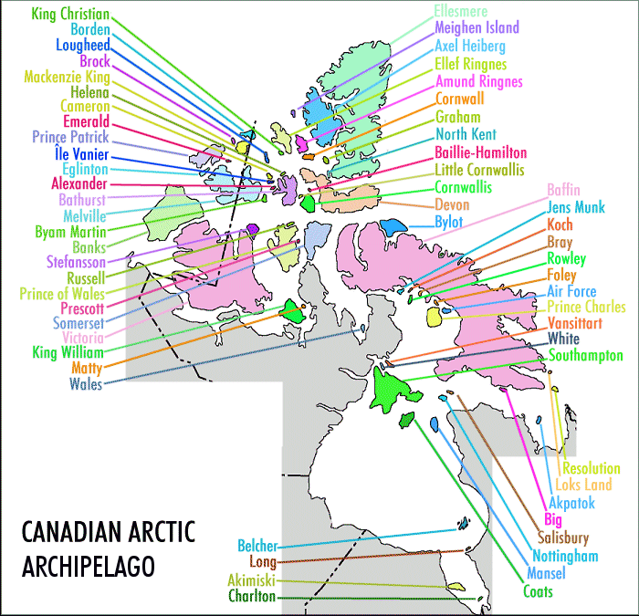
The archipelago extends some 2,400km (1,500mi) longitudinally and 1,900km (1,200mi) from the mainland to Cape Columbia, the northernmost point on Ellesmere Island. It is bounded on the west by the Beaufort Sea; on the northwest by the Arctic Ocean; on the east by Greenland, Baffin Bay and Davis Strait; and on the south by Hudson Bay and the Canadian mainland. The various islands are separated from each other and the continental mainland by a series of waterways collectively known as the Northwest Passage. Two large peninsulas, Boothia and Melville, extend northward from the mainland. The northernmost cluster of islands, including Ellesmere Island, is known as the Queen Elizabeth Islands and was formerly the Parry Islands.
The archipelago consists of 36,563 islands, of which 94 are classified as major islands, being larger than 130km2 (50sqmi), and cover a total area of 1,400,000km2 (540,000sqmi).[13]
The islands of the Canadian Arctic over 5,000km2 (1,900sqmi), in order of descending area, are:[1] As of 2021[update] the total population of all islands in the Arctic was 23,073.[2][3]
The summer home to hundreds of thousands of migratory birds who nest at Banks Island Migratory Bird Sanctuary No. 1 and Banks Island Migratory Bird Sanctuary No. 2[19][20]
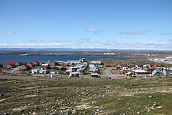
After Greenland, the archipelago is the world's largest high-Arctic land area. The climate of the islands is Arctic, and the terrain consists of tundra except in mountainous regions. Most of the islands are uninhabited; human settlement is extremely thin and scattered, being mainly coastal Inuit settlements on the southern islands.
Of the more than 36,000 islands, only 11 are populated. Baffin Island, the largest, also has the largest population of 13,309.[2] The population accounts for 67.37 per cent of the 19,355 people in the Qikiqtaaluk Region, 56.51 per cent of the population of the Arctic Archipelago, and 35.38 per cent of the population of Nunavut.[2][3]
↑"Sector13.Hudson Strait"(PDF). National Geospatial Intelligence Agency. pollux.nss.nima.mil. pp.14–15. Archived from the original(PDF) on 24 October 2004. Retrieved 27 May 2022.
Aiken, S.G., M.J. Dallwitz, L.L. Consaul, et al. Flora of the Canadian Arctic Archipelago: Descriptions, Illustrations, Identification, and Information Retrieval[CD]. Ottawa: NRC Research Press; Ottawa: Canadian Museum of Nature, 2007. ISBN978-0-660-19727-2.
Aiken, S. G., Laurie Lynn Consaul, and M. J. Dallwitz. Grasses of the Canadian Arctic Archipelago. Ottawa: Research Division, Canadian Museum of Nature, 1995.
Balkwill, H.R.; Embry, Ashton F. (1982). Arctic Geology and Geophysics: Proceedings of the Third International Symposium on Arctic Geology (Hardcover). Canadian Society of Petroleum Geologists. ISBN0-920230-19-9.
Brown, Roger James Evan. Permafrost in the Canadian Arctic Archipelago. National Research Council of Canada, Division of Building Research, 1972.
Cota GF, LW Cooper, DA Darby, and IL Larsen. 2006. "Unexpectedly High Radioactivity Burdens in Ice-Rafted Sediments from the Canadian Arctic Archipelago". The Science of the Total Environment. 366, no. 1: 253–61.
Dunphy, Michael. Validation of a modelling system for tides in the Canadian Arctic Archipelago. Canadian technical report of hydrography and ocean sciences, 243. Dartmouth, N.S.: Fisheries and Oceans Canada, 2005.
Glass, Donald J.; Embry, Ashton F.; McMillan, N. J. (26 February 1988). Devonian of the World: Proceedings of the Second International Symposium on the Devonian System (Hardcover). Calgary, Canada: Canadian Society of Petroleum Geologists. ISBN0-920230-47-4.
Hamilton, Paul B., Konrad Gajewski, David E. Atkinson, and David R.S. Lean. 2001. "Physical and Chemical Limnology of 204 Lakes from the Canadian Arctic Archipelago". Hydrobiologia. 457, no. 1/3: 133–148.
Mi︠a︡rss, Tiĭu, Mark V. H. Wilson, and R. Thorsteinsson. Silurian and Lower Devonian Thelodonts and Putative Chondrichthyans from the Canadian Arctic Archipelago. Special papers in palaeontology, no. 75. London: Palaeontological Association, 2006. ISBN0-901702-99-4
Michel, C Ingram, R G, and L R Harris. 2006. "Variability in Oceanographic and Ecological Processes in the Canadian Arctic Archipelago". Progress in Oceanography. 71, no. 2: 379.
Porsild, A.E.The Vascular Plants of the Western Canadian Arctic Archipelago. Ottawa: E. Cloutier, Queen's printer, 1955.
Rae, R. W. Climate of the Canadian Arctic Archipelago. Toronto: Canada Dept. of Transport, 1951.
Thorsteinsson, R., and Ulrich Mayr. The Sedimentary Rocks of Devon Island, Canadian Arctic Archipelago. Ottawa, Canada: Geological Survey of Canada, 1987. ISBN0-660-12319-3
Van der Baaren, Augustine, and S. J. Prinsenberg. Geostrophic transport estimates from the Canadian Arctic Archipelago. Dartmouth, N.S.: Ocean Sciences Division, Maritimes Region, Fisheries and Oceans Canada, Bedford Institute of Oceanography, 2002.
This page is based on this Wikipedia article Text is available under the CC BY-SA 4.0 license; additional terms may apply. Images, videos and audio are available under their respective licenses.