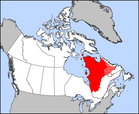
Geography of Quebec

Last updated

The Quebec territory. Map of Quebec.png
The Quebec territory.
Approximate areas of ecoregions
.mw-parser-output .legend{page-break-inside:avoid;break-inside:avoid-column}.mw-parser-output .legend-color{display:inline-block;min-width:1.25em;height:1.25em;line-height:1.25;margin:1px 0;text-align:center;border:1px solid black;background-color:transparent;color:black}.mw-parser-output .legend-text{}
1. Middle Arctic Tundra
2. Low Arctic Tundra
3. Torngat Mountain Tundra
4. Eastern Canadian Shield Taiga
5. Southern Hudson Bay Taiga
6. Central Canadian Shield Forests
7. Eastern Canadian Forests
8. Eastern Forest/Boreal Transition
9. Eastern Great Lakes Lowland Forests
10. New England/Acadian Forests
11. Gulf of St. Lawrence Lowland Forests Ecoregions quebec map.svg
Approximate areas of ecoregions
  1. Middle Arctic Tundra
  2. Low Arctic Tundra
  3. Torngat Mountain Tundra
  4. Eastern Canadian Shield Taiga
  5. Southern Hudson Bay Taiga
  6. Central Canadian Shield Forests
  7. Eastern Canadian Forests
  8. Eastern Forest/Boreal Transition
  9. Eastern Great Lakes Lowland Forests
  10. New England/Acadian Forests
  11. Gulf of St. Lawrence Lowland Forests

Located in the eastern part of Canada, and (from a historical and political perspective) part of Central Canada, Quebec occupies a territory nearly three times the size of France or Texas. It is much closer to the size of Alaska. As is the case with Alaska, most of the land in Quebec is very sparsely populated. [1] Its topography is very different from one region to another due to the varying composition of the ground, the climate (latitude and altitude), and the proximity to water. The Great Lakes–St. Lawrence Lowlands and the Appalachians are the two main topographic regions in southern Quebec, while the Canadian Shield occupies most of central and northern Quebec. [2]

Contents

With an area of 1,542,056 km2 (595,391 sq mi), it is the largest of Canada's provinces and territories and the tenth largest country subdivision in the world.[ citation needed ] More than 90% of Quebec's area lies within the Canadian Shield, and includes the greater part of the Labrador Peninsula. Quebec's highest mountain is Mont D'Iberville, which is located on the border with Newfoundland and Labrador in the northeastern part of the province in the Torngat Mountains. The addition of parts of the vast and scarcely populated District of Ungava of the Northwest Territories between 1898 and 1912 gave the province its current form.

The territory of Quebec is extremely rich in resources in its coniferous forests, lakes, and rivers pulp and paper, lumber, and hydroelectricity are still some of the province's most important industries.[ citation needed ] The far north of the province, Nunavik, is subarctic or Arctic and is mostly inhabited by Inuit.

The most populous region is the Saint Lawrence River valley in the south, where the capital, Quebec City, and the largest city, Montreal, are situated. North of Montreal are the Laurentians, a range of ancient mountains, and to the east are the Appalachian Mountains which extends into the Eastern Townships and Gaspésie regions. The Gaspé Peninsula juts into the Gulf of Saint Lawrence to the East. The Saint Lawrence River Valley is a fertile agricultural region, producing dairy products, fruit, vegetables, maple sugar (Quebec is the world's largest producer of maple syrup [3] ), and livestock.

Borders

Quebec is bordered by the province of Ontario, James Bay and Hudson Bay (including the circular Nastapoka arc) to the west, the provinces of New Brunswick and Newfoundland and Labrador to the east and Hudson Strait and Ungava Bay to the north. Its northernmost point is Cape Wolstenholme. Quebec also shares a land border with four northeast states of the United States (Maine, New Hampshire, New York and Vermont) to the south. [4]

In 1927, the border between the Province of Quebec and the Dominion of Newfoundland was delineated by the British Judicial Committee of the Privy Council. The government of Quebec does not officially recognize the Newfoundland and Labrador–Quebec border. A border dispute remains regarding the ownership of Labrador. [5] [6] A maritime boundary also exists with the territories of Nunavut, Prince Edward Island and Nova Scotia. Quebec has officially more than 12,000 km (7,500 mi) of borders of all types. Half of these are land limits, 12% river limits and 38% marine limits. [4]

Topography

Satellite view of three Monteregian Hills (Saint Hilaire, Rougemont, and Yamaska) in Saint Lawrence Lowlands Monteregian Hills from space.jpg
Satellite view of three Monteregian Hills (Saint Hilaire, Rougemont, and Yamaska) in Saint Lawrence Lowlands
Jacques-Cartier River Scotora2 PJC.jpg
Jacques-Cartier River

Quebec's highest point at 1,652 m (5,420 ft) is Mont d'Iberville, known in English as Mount Caubvick, located on the border with Newfoundland and Labrador in the northeastern part of the province, in the Torngat Mountains. [7] The most populous physiographic region is the Great Lakes–St. Lawrence Lowlands. It extends northeastward from the southwestern portion of the province along the shores of the Saint Lawrence River to the Quebec City region, limited to the North by the Laurentian Mountains and to the South by the Appalachians. It mainly covers the areas of the Centre-du-Québec, Laval, Montérégie and Montreal, the southern regions of the Capitale-Nationale, Lanaudière, Laurentides, Mauricie. It includes Anticosti Island, the Mingan Archipelago, [8] and other small islands of the Gulf of St. Lawrence lowland forests ecoregion. [9] Its landscape is low-lying and flat, except for isolated igneous outcrops near Montreal called the Monteregian Hills, formerly covered by the waters of Lake Champlain. The Oka hills also rise from the plain. Geologically, the lowlands formed as a rift valley about 100 million years ago and are prone to infrequent but significant earthquakes. [2] The most recent sedimentary rock layerswere formed as the seabed of the ancient Champlain Sea at the end of the last ice age about 14,000 years ago. [10] The combination of rich and easily arable soils and Quebec's relatively warm climate makes this valley the most prolific agricultural area of Quebec province. Mixed forests provide most of Canada's springtime maple syrup crop. The rural part of the landscape is divided into narrow rectangular tracts of land that extend from the river and date back to settlement patterns in 17th century New France.

Autumn landscape of Haute-Gaspesie Automne-manche d'epee 592K -2.jpg
Autumn landscape of Haute-Gaspésie

More than 95% of Quebec's territory lies within the Canadian Shield. [11] It is generally a quite flat and exposed mountainous terrain interspersed with higher points such as the Laurentian Mountains in southern Quebec, the Otish Mountains in central Quebec and the Torngat Mountains near Ungava Bay. The topography of the Shield has been shaped by glaciers from the successive ice ages, which explains the glacial deposits of boulders, gravel and sand, and by sea water and post-glacial lakes that left behind thick deposits of clay in parts of the Shield. The Canadian Shield also has a complex hydrological network of perhaps a million lakes, bogs, streams and rivers. It is rich in the forestry, mineral and hydro-electric resources that are a mainstay of the Quebec economy. Primary industries sustain small cities in regions of Abitibi-Témiscamingue, Saguenay–Lac-Saint-Jean, and Côte-Nord.

Mont Tremblant Resort, Laurentian Mountains Mont Tremblant village.jpeg
Mont Tremblant Resort, Laurentian Mountains

The Labrador Peninsula is covered by the Laurentian Plateau (or Canadian Shield), dotted with mountains such as Otish Mountains. The Ungava Peninsula is notably composed of D'Youville mountains, Puvirnituq mountains and Pingualuit crater. While low and medium altitude peak from western Quebec to the far north, high altitudes mountains emerge in the Capitale-Nationale region to the extreme east, along its longitude. In the Labrador Peninsula portion of the Shield, the far northern region of Nunavik includes the Ungava Peninsula and consists of flat Arctic tundra inhabited mostly by the Inuit. Further south lie the subarctic taiga of the Eastern Canadian Shield taiga ecoregion and the boreal forest of the Central Canadian Shield forests, where spruce, fir, and poplar trees provide raw materials for Quebec's pulp and paper and lumber industries. Although the area is inhabited principally by the Cree, Naskapi, and Innu First Nations, thousands of temporary workers reside at Radisson to service the massive James Bay Hydroelectric Project on the La Grande and Eastmain rivers. The southern portion of the shield extends to the Laurentians, a mountain range just north of the Great Lakes–St. Lawrence Lowlands, that attracts local and international tourists to ski hills and lakeside resorts.

The Appalachian region of Quebec has a narrow strip of ancient mountains along the southeastern border of Quebec. The Appalachians are actually a huge chain that extends from Alabama to Newfoundland. In between, it covers in Quebec near 800 km (500 mi), from the Montérégie hills to the Gaspé Peninsula. In western Quebec, the average altitude is about 500 m (1,600 ft), while in the Gaspé Peninsula, the Appalachian peaks (especially the Chic-Choc) are among the highest in Quebec, exceeding 1,000 m (3,300 ft).

Hydrography

Quebec has several notable islands, namely the numerous islands of the Hochelaga Archipelago that includes the Island of Montreal and Îles Laval which make up full or parts of the major cities of Montreal and Laval. Île d'Orléans near Quebec City, the sparsely populated Anticosti Island in the outlet of the Saint Lawrence River, and the Magdalen Islands archipelago in the Gulf of Saint Lawrence are other noteworthy islands.

Quebec has one of the world's largest reserves of fresh water, [12] occupying 12% of its surface. [13] It has 3% of the world's renewable fresh water, whereas it has only 0.1% of its population. [14] More than half a million lakes, [12] including 30 with an area greater than 250 km2 (97 sq mi), and 4,500 rivers [12] drain into the Atlantic Ocean, through the Gulf of Saint Lawrence and the Arctic Ocean, by James, Hudson, and Ungava bays. The largest inland body of water is the Caniapiscau Reservoir, created in the realization of the James Bay Project to produce hydroelectric power. Lake Mistassini is the largest natural lake in Quebec. [15]

Michel's falls on Ashuapmushuan River in Saint-Felicien, Saguenay-Lac-Saint-Jean Chutes a Michel.jpg
Michel's falls on Ashuapmushuan River in Saint-Félicien, Saguenay–Lac-Saint-Jean

The Saint Lawrence River has some of the world's largest sustaining inland Atlantic ports at Montreal (the province's largest city), Trois-Rivières, and Quebec City (the capital). Its access to the Atlantic Ocean and the interior of North America made it the base of early French exploration and settlement in the 17th and 18th centuries. Since 1959, the Saint Lawrence Seaway has provided a navigable link between the Atlantic Ocean and the Great Lakes. Northeast of Quebec City, the river broadens into the world's largest estuary, the feeding site of numerous species of whales, fish, and seabirds. [16] The river empties into the Gulf of Saint Lawrence. This marine environment sustains fisheries and smaller ports in the Lower Saint Lawrence (Bas-Saint-Laurent), Lower North Shore (Côte-Nord), and Gaspé (Gaspésie) regions of the province. The Saint Lawrence River with its estuary forms the basis of Quebec's development through the centuries. Other notable rivers include the Ashuapmushuan, Chaudière, Gatineau, Manicouagan, Ottawa, Richelieu, Rupert, Saguenay, Saint-François, and Saint-Maurice.

Climate

Koppen climate types of Quebec Quebec Koppen.svg
Köppen climate types of Quebec

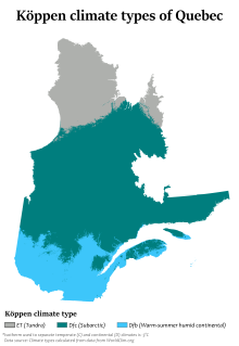
In general, the climate of Quebec is cold and humid. [17] The climate of the province is largely determined by its latitude, maritime and elevation influences. [17] According to the Köppen climate classification, Quebec has three main climate regions. [17] Southern and western Quebec, including most of the major population centres and areas south of 51oN, have a humid continental climate (Köppen climate classification Dfb) with four distinct seasons having warm to occasionally hot and humid summers and often very cold and snowy winters. [17] [18]

The main climatic influences are from western and northern Canada and move eastward, and from the southern and central United States that move northward. Because of the influence of both storm systems from the core of North America and the Atlantic Ocean, precipitation is abundant throughout the year, with most areas receiving more than 1,000 mm (39 in) of precipitation, including over 300 cm (120 in) of snow in many areas. [19] During the summer, severe weather patterns (such as tornadoes and severe thunderstorms) occur occasionally. [20] Most of central Quebec, ranging from 51 to 58 degrees North has a subarctic climate (Köppen Dfc). [17] Winters are long, very cold, and snowy, and among the coldest in eastern Canada, while summers are warm but very short due to the higher latitude and the greater influence of Arctic air masses. Precipitation is also somewhat less than farther south, except at some of the higher elevations. The northern regions of Quebec have an arctic climate (Köppen ET), with very cold winters and short, much cooler summers. [17] The primary influences in this region are the Arctic Ocean currents (such as the Labrador Current) and continental air masses from the High Arctic.

Baie-Saint-Paul during winter Baie-Saint-Paul.jpg
Baie-Saint-Paul during winter

The four calendar seasons in Quebec are spring, summer, autumn and winter, with conditions differing by region. They are then differentiated according to the insolation, temperature, and precipitation of snow and rain. [21] In Quebec City, the length of the daily sunshine varies from 8:37 hrs in December to 15:50 hrs in June; the annual variation is much greater (from 4:54 to 19:29 hrs) at the northern tip of the province. [22] From temperate zones to the northern territories of the Far North, the brightness varies with latitude, as well as the Northern Lights and midnight sun.

Quebec is divided into four climatic zones: arctic, subarctic, humid continental and East maritime. From south to north, average temperatures range in summer between 25 and 5 °C (77 and 41 °F) and, in winter, between −10 and −25 °C (14 and −13 °F). [23] [24] In periods of intense heat and cold, temperatures can reach 35 °C (95 °F) in the summer [25] and −40 °C (−40 °F) during the Quebec winter, [25] They may vary depending on the Humidex or Wind chill. The all time record high was 40.0 °C (104.0 °F) and the all time record low was −51.0 °C (−59.8 °F). [26]

The all-time record of the greatest precipitation in winter was established in winter 2007–2008, with more than five metres [27] of snow in the area of Quebec City, while the average amount received per winter is around three metres. [28] March 1971, however, saw the "Century's Snowstorm" with more than 40 cm (16 in) in Montreal to 80 cm (31 in) in Mont Apica of snow within 24 hours in many regions of southern Quebec. Also, the winter of 2010 was the warmest and driest recorded in more than 60 years. [29]

Average daily maximum and minimum temperatures for selected locations in Quebec [30]
LocationJuly (°C)July (°F)January (°C)January (°F)
Montreal 26/1679/61−5/−1422/7
Gatineau 26/1579/60−6/−1521/5
Quebec City 25/1377/56−8/−1817/0
Trois-Rivières 25/1478/58−7/−1719/1
Sherbrooke 24/1176/53−6/−1821/0
Saguenay 24/1275/54−10/−2114/−6
Matagami 23/973/48−13/−268/−16
Kuujjuaq 17/663/43−20/−29−4/−20
Inukjuak 13/556/42−21/−28−6/−19

Climate tables

Climate data for Montreal (Montréal–Trudeau International Airport)
WMO ID: 71627; coordinates 45°28′N73°45′W / 45.467°N 73.750°W / 45.467; -73.750 (Montréal–Trudeau International Airport) ; elevation: 36 m (118 ft); 1981−2010 normals, extremes 1941−present
MonthJanFebMarAprMayJunJulAugSepOctNovDecYear
Record high humidex 13.514.728.033.840.945.045.846.842.833.526.218.146.8
Record high °C (°F)13.9
(57.0)
15.1
(59.2)
25.8
(78.4)
30.0
(86.0)
36.6
(97.9)
35.0
(95.0)
35.6
(96.1)
37.6
(99.7)
33.5
(92.3)
28.3
(82.9)
24.3
(75.7)
18.0
(64.4)
37.6
(99.7)
Mean daily maximum °C (°F)−5.3
(22.5)
−3.2
(26.2)
2.5
(36.5)
11.6
(52.9)
18.9
(66.0)
23.9
(75.0)
26.3
(79.3)
25.3
(77.5)
20.6
(69.1)
13.0
(55.4)
5.9
(42.6)
−1.4
(29.5)
11.5
(52.7)
Daily mean °C (°F)−9.7
(14.5)
−7.7
(18.1)
−2
(28)
6.4
(43.5)
13.4
(56.1)
18.6
(65.5)
21.2
(70.2)
20.1
(68.2)
15.5
(59.9)
8.5
(47.3)
2.1
(35.8)
−5.4
(22.3)
6.8
(44.2)
Mean daily minimum °C (°F)−14.0
(6.8)
−12.2
(10.0)
−6.5
(20.3)
1.2
(34.2)
7.9
(46.2)
13.2
(55.8)
16.1
(61.0)
14.8
(58.6)
10.3
(50.5)
3.9
(39.0)
−1.7
(28.9)
−9.3
(15.3)
2.0
(35.6)
Record low °C (°F)−37.8
(−36.0)
−33.9
(−29.0)
−29.4
(−20.9)
−15.0
(5.0)
−4.4
(24.1)
0.0
(32.0)
6.1
(43.0)
3.3
(37.9)
−2.2
(28.0)
−7.2
(19.0)
−19.4
(−2.9)
−32.4
(−26.3)
−37.8
(−36.0)
Record low wind chill −49.1−46.0−42.9−26.3−9.90.00.00.0−4.8−10.9−30.7−46.0−49.1
Average precipitation mm (inches)77.2
(3.04)
62.7
(2.47)
69.1
(2.72)
82.2
(3.24)
81.2
(3.20)
87.0
(3.43)
89.3
(3.52)
94.1
(3.70)
83.1
(3.27)
91.3
(3.59)
96.4
(3.80)
86.8
(3.42)
1,000.3
(39.38)
Average rainfall mm (inches)27.3
(1.07)
20.9
(0.82)
29.7
(1.17)
67.7
(2.67)
81.2
(3.20)
87.0
(3.43)
89.3
(3.52)
94.1
(3.70)
83.1
(3.27)
89.1
(3.51)
76.7
(3.02)
38.8
(1.53)
784.9
(30.90)
Average snowfall cm (inches)49.5
(19.5)
41.2
(16.2)
36.2
(14.3)
12.9
(5.1)
0.0
(0.0)
0.0
(0.0)
0.0
(0.0)
0.0
(0.0)
0.0
(0.0)
1.8
(0.7)
19.0
(7.5)
48.9
(19.3)
209.5
(82.5)
Average precipitation days (≥ 0.2 mm)16.713.713.612.913.613.312.311.611.113.314.816.3163.3
Average rainy days (≥ 0.2 mm)4.24.06.911.613.613.312.311.611.113.011.75.9119.1
Average snowy days (≥ 0.2 cm)15.312.19.13.20.070.00.00.00.00.725.413.058.9
Average relative humidity (%) (at 1500)68.163.458.351.951.455.356.156.859.762.068.071.460.2
Mean monthly sunshine hours 101.2127.8164.3178.3228.9240.3271.5246.3182.2143.583.683.62,051.3
Percent possible sunshine 35.743.744.644.049.651.357.356.348.342.229.230.744.4
Average ultraviolet index 1235677753114
Source: Environment and Climate Change Canada [31] [32] [33] [34] [35] and Weather Atlas [36]
Climate data for Sainte-Foy, Quebec City (Québec City Jean Lesage International Airport)
WMO ID: 71708; coordinates 46°48′N71°23′W / 46.800°N 71.383°W / 46.800; -71.383 (Québec City Jean Lesage International Airport) ; elevation: 74.4 m (244 ft); 1981–2010 normals, extremes 1875–present [note 1]
MonthJanFebMarAprMayJunJulAugSepOctNovDecYear
Record high humidex 10.611.717.832.940.344.149.249.340.130.924.914.649.3
Record high °C (°F)11.1
(52.0)
11.7
(53.1)
18.3
(64.9)
29.9
(85.8)
33.0
(91.4)
34.4
(93.9)
36.1
(97.0)
35.6
(96.1)
33.9
(93.0)
28.3
(82.9)
22.9
(73.2)
15.0
(59.0)
36.1
(97.0)
Mean daily maximum °C (°F)−7.9
(17.8)
−5.6
(21.9)
0.2
(32.4)
8.3
(46.9)
17.0
(62.6)
22.3
(72.1)
25.0
(77.0)
23.6
(74.5)
17.9
(64.2)
11.1
(52.0)
2.9
(37.2)
−4.2
(24.4)
9.2
(48.6)
Daily mean °C (°F)−12.8
(9.0)
−10.6
(12.9)
−4.6
(23.7)
3.7
(38.7)
11.2
(52.2)
16.4
(61.5)
19.3
(66.7)
18.1
(64.6)
12.7
(54.9)
6.6
(43.9)
−0.7
(30.7)
−8.6
(16.5)
4.2
(39.6)
Mean daily minimum °C (°F)−17.7
(0.1)
−15.6
(3.9)
−9.4
(15.1)
−1.0
(30.2)
5.4
(41.7)
10.5
(50.9)
13.5
(56.3)
12.5
(54.5)
7.5
(45.5)
2.0
(35.6)
−4.2
(24.4)
−12.8
(9.0)
−0.8
(30.6)
Record low °C (°F)−36.7
(−34.1)
−36.1
(−33.0)
−30.0
(−22.0)
−18.9
(−2.0)
−7.8
(18.0)
−0.6
(30.9)
3.9
(39.0)
2.2
(36.0)
−4.8
(23.4)
−10.0
(14.0)
−26.1
(−15.0)
−35.6
(−32.1)
−36.7
(−34.1)
Record low wind chill −51.1−52.4−41.0−29.0−13.60.00.00.0−7.8−17.3−30.8−48.4−52.4
Average precipitation mm (inches)86.6
(3.41)
74.5
(2.93)
76.1
(3.00)
83.5
(3.29)
115.9
(4.56)
111.4
(4.39)
121.4
(4.78)
104.2
(4.10)
115.5
(4.55)
98.3
(3.87)
102.5
(4.04)
99.9
(3.93)
1,189.7
(46.84)
Average rainfall mm (inches)22.7
(0.89)
15.2
(0.60)
30.2
(1.19)
67.5
(2.66)
115.9
(4.56)
111.4
(4.39)
121.4
(4.78)
104.2
(4.10)
115.5
(4.55)
94.6
(3.72)
69.1
(2.72)
31.7
(1.25)
899.3
(35.41)
Average snowfall cm (inches)71.9
(28.3)
63.6
(25.0)
46.4
(18.3)
13.2
(5.2)
0.0
(0.0)
0.0
(0.0)
0.0
(0.0)
0.0
(0.0)
0.0
(0.0)
3.2
(1.3)
32.7
(12.9)
72.4
(28.5)
303.4
(119.4)
Average precipitation days (≥ 0.2 mm)17.114.313.412.115.413.413.513.413.414.416.018.5174.9
Average rainy days (≥ 0.2 mm)3.02.44.710.415.313.413.513.413.414.110.14.5118.2
Average snowy days (≥ 0.2 cm)16.313.210.54.30.130.00.00.00.01.08.116.670.1
Average relative humidity (%) (at 3pm)67.864.660.755.951.656.059.159.161.863.170.473.261.9
Mean monthly sunshine hours 98.9121.2152.0170.6211.1234.7252.3232.0163.0122.076.681.91,916.3
Percent possible sunshine 35.541.841.341.945.349.652.752.743.136.027.130.741.5
Average ultraviolet index 1234677653114
Source: Environment and Climate Change Canada, [37] [38] extremes 1875–1959 [39] and Weather Atlas [40]
Climate data for Trois-Rivières (Aqueduc)
Climate ID: 701HE63; coordinates 46°23′N73°37′W / 46.383°N 73.617°W / 46.383; -73.617 (Sept-Îles Airport) ; elevation: 54.9 m (180 ft); 1981−2010 normals, extremes 1920−present [lower-alpha 1]
MonthJanFebMarAprMayJunJulAugSepOctNovDecYear
Record high °C (°F)13.0
(55.4)
11.1
(52.0)
20.0
(68.0)
31.5
(88.7)
33.3
(91.9)
34.5
(94.1)
37.8
(100.0)
36.1
(97.0)
32.5
(90.5)
28.9
(84.0)
22.2
(72.0)
14.6
(58.3)
37.8
(100.0)
Mean daily maximum °C (°F)−7.1
(19.2)
−4.4
(24.1)
1.4
(34.5)
9.9
(49.8)
18.2
(64.8)
23.3
(73.9)
25.5
(77.9)
24.4
(75.9)
19.4
(66.9)
11.9
(53.4)
4.1
(39.4)
−3.1
(26.4)
10.3
(50.5)
Daily mean °C (°F)−12.1
(10.2)
−9.7
(14.5)
−3.6
(25.5)
4.8
(40.6)
12.3
(54.1)
17.6
(63.7)
20.0
(68.0)
18.9
(66.0)
14.2
(57.6)
7.4
(45.3)
0.5
(32.9)
−7.4
(18.7)
5.2
(41.4)
Mean daily minimum °C (°F)−17.1
(1.2)
−14.9
(5.2)
−8.6
(16.5)
−0.3
(31.5)
6.3
(43.3)
11.8
(53.2)
14.4
(57.9)
13.4
(56.1)
8.9
(48.0)
2.8
(37.0)
−3.1
(26.4)
−11.6
(11.1)
0.2
(32.4)
Record low °C (°F)−41.1
(−42.0)
−41.7
(−43.1)
−35.0
(−31.0)
−20.0
(−4.0)
−7.8
(18.0)
−1.5
(29.3)
3.5
(38.3)
0.0
(32.0)
−7.2
(19.0)
−11.7
(10.9)
−27.2
(−17.0)
−35.6
(−32.1)
−41.7
(−43.1)
Average precipitation mm (inches)82.9
(3.26)
68.8
(2.71)
75.6
(2.98)
79.2
(3.12)
96.3
(3.79)
107.0
(4.21)
116.8
(4.60)
101.3
(3.99)
100.6
(3.96)
98.4
(3.87)
102.4
(4.03)
93.4
(3.68)
1,122.8
(44.20)
Average rainfall mm (inches)24.5
(0.96)
19.5
(0.77)
32.0
(1.26)
66.8
(2.63)
96.3
(3.79)
107.0
(4.21)
116.8
(4.60)
101.3
(3.99)
100.6
(3.96)
95.7
(3.77)
75.4
(2.97)
28.1
(1.11)
863.9
(34.01)
Average snowfall cm (inches)58.5
(23.0)
49.3
(19.4)
43.6
(17.2)
12.5
(4.9)
0.0
(0.0)
0.0
(0.0)
0.0
(0.0)
0.0
(0.0)
0.0
(0.0)
2.8
(1.1)
27.1
(10.7)
65.3
(25.7)
259.0
(102.0)
Average precipitation days (≥ 0.2 mm)13.911.911.111.914.414.415.012.812.814.314.414.2161.1
Average rainy days (≥ 0.2 mm)2.92.65.410.514.414.415.012.812.814.210.44.0119.5
Average snowy days (≥ 0.2 cm)12.310.37.02.70.070.00.00.00.00.655.611.550.2
Mean monthly sunshine hours 84.5110.4157.3166.9208.7220.9257.9205.3158.2121.369.362.21,823.1
Percent possible sunshine 30.137.942.741.145.046.954.146.841.935.824.423.139.1
Source: Environment and Climate Change Canada. [41] [42] [43] [44] Sunshine data recorded at Nicolet [45]
Climate data for Baie-Comeau (Baie-Comeau Airport)
Climate ID: 7040440; coordinates 49°08′N68°12′W / 49.133°N 68.200°W / 49.133; -68.200 (Baie-Comeau Airport) ; elevation: 21.6 m (71 ft); 1981–2010 normals
MonthJanFebMarAprMayJunJulAugSepOctNovDecYear
Record high humidex 8.88.49.621.730.439.138.346.333.231.820.29.046.3
Record high °C (°F)11.4
(52.5)
8.2
(46.8)
10.3
(50.5)
21.8
(71.2)
30.0
(86.0)
31.8
(89.2)
32.8
(91.0)
31.1
(88.0)
28.1
(82.6)
21.7
(71.1)
18.1
(64.6)
13.9
(57.0)
32.8
(91.0)
Mean daily maximum °C (°F)−8.7
(16.3)
−6.7
(19.9)
−1.5
(29.3)
4.5
(40.1)
11.9
(53.4)
18.0
(64.4)
20.9
(69.6)
20.2
(68.4)
15.2
(59.4)
8.5
(47.3)
1.9
(35.4)
−4.5
(23.9)
6.6
(43.9)
Daily mean °C (°F)−14.3
(6.3)
−12.7
(9.1)
−6.5
(20.3)
0.6
(33.1)
6.8
(44.2)
12.4
(54.3)
15.6
(60.1)
14.7
(58.5)
10.1
(50.2)
4.3
(39.7)
−1.8
(28.8)
−9.3
(15.3)
1.7
(35.1)
Mean daily minimum °C (°F)−19.9
(−3.8)
−18.6
(−1.5)
−11.4
(11.5)
−3.2
(26.2)
1.7
(35.1)
6.8
(44.2)
10.3
(50.5)
9.2
(48.6)
5.0
(41.0)
0.1
(32.2)
−5.5
(22.1)
−14.1
(6.6)
−3.3
(26.1)
Record low °C (°F)−47.2
(−53.0)
−44.4
(−47.9)
−35.6
(−32.1)
−21.0
(−5.8)
−8.3
(17.1)
−3.2
(26.2)
0.6
(33.1)
−0.7
(30.7)
−6.1
(21.0)
−11.0
(12.2)
−22.8
(−9.0)
−37.8
(−36.0)
−47.2
(−53.0)
Record low wind chill −53.0−56.9−48.3−29.5−19.0−4.80.0−2.7−8.4−15.1−31.1−51.5−56.9
Average precipitation mm (inches)83.4
(3.28)
65.2
(2.57)
68.4
(2.69)
79.7
(3.14)
91.1
(3.59)
88.7
(3.49)
93.1
(3.67)
75.4
(2.97)
86.3
(3.40)
95.3
(3.75)
95.8
(3.77)
78.7
(3.10)
1,001
(39.41)
Average rainfall mm (inches)12.3
(0.48)
14.4
(0.57)
23.7
(0.93)
50.7
(2.00)
88.3
(3.48)
88.7
(3.49)
93.1
(3.67)
75.4
(2.97)
86.3
(3.40)
90.0
(3.54)
57.7
(2.27)
17.0
(0.67)
697.6
(27.46)
Average snowfall cm (inches)83.8
(33.0)
59.1
(23.3)
48.2
(19.0)
30.3
(11.9)
2.7
(1.1)
0.0
(0.0)
0.0
(0.0)
0.0
(0.0)
0.01
(0.00)
5.4
(2.1)
40.2
(15.8)
73.2
(28.8)
342.9
(135.0)
Average precipitation days (≥ 0.2 mm)16.212.812.812.314.213.514.613.513.515.014.114.8167.3
Average rainy days (≥ 0.2 mm)1.61.83.78.314.113.514.613.513.514.88.72.6110.9
Average snowy days (≥ 0.2 cm)16.811.810.76.20.890.00.00.00.051.78.614.371.1
Mean monthly sunshine hours 112.5134.4163.5181.7217.3237.1244.0238.4163.8123.490.794.72,001.5
Percent possible sunshine 41.647.044.444.245.849.049.953.543.236.832.936.843.8
Source: Environment and Climate Change Canada [46]
Climate data for Sept-Îles (Sept-Îles Airport)
Climate ID: 7047910; coordinates 50°13′N66°16′W / 50.217°N 66.267°W / 50.217; -66.267 (Sept-Îles Airport) ; elevation: 54.9 m (180 ft); 1981−2010 normals, extremes 1903−present [lower-alpha 2]
MonthJanFebMarAprMayJunJulAugSepOctNovDecYear
Record high °C (°F)10.0
(50.0)
10.6
(51.1)
16.4
(61.5)
19.2
(66.6)
28.3
(82.9)
32.2
(90.0)
32.2
(90.0)
31.1
(88.0)
29.4
(84.9)
22.2
(72.0)
16.9
(62.4)
9.4
(48.9)
32.2
(90.0)
Mean daily maximum °C (°F)−9.8
(14.4)
−7.9
(17.8)
−1.9
(28.6)
4.0
(39.2)
10.7
(51.3)
16.5
(61.7)
19.5
(67.1)
19.1
(66.4)
14.2
(57.6)
7.8
(46.0)
1.0
(33.8)
−5.6
(21.9)
5.6
(42.1)
Daily mean °C (°F)−15.3
(4.5)
−13.6
(7.5)
−6.8
(19.8)
0.2
(32.4)
6.2
(43.2)
11.8
(53.2)
15.2
(59.4)
14.4
(57.9)
9.8
(49.6)
3.7
(38.7)
−2.9
(26.8)
−10.5
(13.1)
1.0
(33.8)
Mean daily minimum °C (°F)−20.8
(−5.4)
−19.3
(−2.7)
−11.7
(10.9)
−3.7
(25.3)
1.7
(35.1)
7.0
(44.6)
10.8
(51.4)
9.8
(49.6)
5.3
(41.5)
−0.4
(31.3)
−6.7
(19.9)
−15.3
(4.5)
−3.6
(25.5)
Record low °C (°F)−43.3
(−45.9)
−38.3
(−36.9)
−31.7
(−25.1)
−26.4
(−15.5)
−11.7
(10.9)
−2.8
(27.0)
1.7
(35.1)
−0.6
(30.9)
−6.5
(20.3)
−12.8
(9.0)
−28.9
(−20.0)
−36.5
(−33.7)
−43.3
(−45.9)
Average precipitation mm (inches)81.7
(3.22)
68.6
(2.70)
81.3
(3.20)
92.1
(3.63)
86.9
(3.42)
99.1
(3.90)
104.4
(4.11)
84.4
(3.32)
108.7
(4.28)
104.1
(4.10)
109.2
(4.30)
99.4
(3.91)
1,119.9
(44.09)
Average rainfall mm (inches)8.3
(0.33)
13.9
(0.55)
24.4
(0.96)
49.2
(1.94)
76.7
(3.02)
99.1
(3.90)
104.4
(4.11)
84.4
(3.32)
108.7
(4.28)
98.0
(3.86)
62.4
(2.46)
18.1
(0.71)
747.5
(29.43)
Average snowfall cm (inches)84.1
(33.1)
59.7
(23.5)
57.8
(22.8)
36.4
(14.3)
8.1
(3.2)
0.0
(0.0)
0.0
(0.0)
0.0
(0.0)
0.05
(0.02)
5.3
(2.1)
46.0
(18.1)
87.2
(34.3)
384.6
(151.4)
Average precipitation days (≥ 0.2 mm)16.513.413.712.713.813.616.414.113.715.514.915.6173.8
Average rainy days (≥ 0.2 mm)1.41.63.97.813.213.616.414.113.814.48.32.7111.0
Average snowy days (≥ 0.2 cm)16.412.512.47.71.70.00.00.00.12.59.714.877.7
Mean monthly sunshine hours 104.0134.4150.8170.1223.4221.2240.9220.4154.0131.293.593.71,937.6
Source: Environment and Climate Change Canada, [47] [48] [49] (sun 1961−1990), [50] Clarke City (1903−1944) [51]
Climate data for La Grande Rivière (La Grande Rivière Airport)
WMO ID: 71827; coordinates 53°38′N77°42′W / 53.633°N 77.700°W / 53.633; -77.700 (La Grande Rivière Airport) ; elevation: 195.1 m (640 ft); 1981–2010 normals
MonthJanFebMarAprMayJunJulAugSepOctNovDecYear
Record high humidex 1.84.811.121.833.937.544.335.531.628.311.77.644.3
Record high °C (°F)1.4
(34.5)
5.0
(41.0)
11.3
(52.3)
22.3
(72.1)
32.6
(90.7)
35.0
(95.0)
37.3
(99.1)
31.2
(88.2)
27.1
(80.8)
23.5
(74.3)
12.3
(54.1)
7.4
(45.3)
37.3
(99.1)
Mean daily maximum °C (°F)−18.5
(−1.3)
−15.9
(3.4)
−8.2
(17.2)
0.6
(33.1)
10.3
(50.5)
17.3
(63.1)
20.4
(68.7)
18.6
(65.5)
12.3
(54.1)
4.8
(40.6)
−3.1
(26.4)
−12.0
(10.4)
2.2
(36.0)
Daily mean °C (°F)−23.2
(−9.8)
−21.6
(−6.9)
−14.5
(5.9)
−5.0
(23.0)
4.3
(39.7)
10.8
(51.4)
14.2
(57.6)
13.1
(55.6)
8.1
(46.6)
1.7
(35.1)
−6.1
(21.0)
−16.0
(3.2)
−2.9
(26.8)
Mean daily minimum °C (°F)−28.0
(−18.4)
−27.3
(−17.1)
−20.7
(−5.3)
−10.6
(12.9)
−1.6
(29.1)
4.2
(39.6)
8.0
(46.4)
7.6
(45.7)
3.8
(38.8)
−1.5
(29.3)
−9.1
(15.6)
−19.9
(−3.8)
−7.9
(17.8)
Record low °C (°F)−40.9
(−41.6)
−44.6
(−48.3)
−39.7
(−39.5)
−31.4
(−24.5)
−14.4
(6.1)
−6.6
(20.1)
−0.9
(30.4)
−0.5
(31.1)
−7.0
(19.4)
−16.7
(1.9)
−29.2
(−20.6)
−40.3
(−40.5)
−44.6
(−48.3)
Record low wind chill −56−57−51−40−24−12−3−6−10−20−40−53−57
Average precipitation mm (inches)30.9
(1.22)
21.9
(0.86)
29.4
(1.16)
32.7
(1.29)
39.0
(1.54)
65.3
(2.57)
78.5
(3.09)
91.1
(3.59)
110.6
(4.35)
87.3
(3.44)
67.9
(2.67)
42.6
(1.68)
697.2
(27.45)
Average rainfall mm (inches)0.1
(0.00)
1.2
(0.05)
3.4
(0.13)
12.7
(0.50)
27.9
(1.10)
62.6
(2.46)
78.5
(3.09)
91.0
(3.58)
106.9
(4.21)
56.2
(2.21)
11.6
(0.46)
1.7
(0.07)
453.8
(17.87)
Average snowfall cm (inches)33.1
(13.0)
23.0
(9.1)
28.6
(11.3)
21.0
(8.3)
11.9
(4.7)
2.6
(1.0)
0.0
(0.0)
0.1
(0.0)
4.0
(1.6)
32.4
(12.8)
60.3
(23.7)
44.4
(17.5)
261.3
(102.9)
Average precipitation days (≥ 0.2 mm)16.312.511.910.812.112.414.116.220.220.622.019.7188.9
Average rainy days (≥ 0.2 mm)0.330.671.104.008.0011.6014.0016.3019.5012.704.100.8492.90
Average snowy days (≥ 0.2 cm)16.412.311.58.55.71.60.040.041.911.820.519.6109.8
Average afternoon relative humidity (%) (at 15:00)73.168.360.357.953.150.354.759.668.975.883.580.365.5
Source: Environment and Climate Change Canada [52]
Climate data for Kuujjuaq (Kuujjuaq Airport)
WMO ID: 71906; coordinates 58°06′N68°25′W / 58.100°N 68.417°W / 58.100; -68.417 (Kuujjuaq Airport) ; elevation: 39.9 m (131 ft); 1991–2020 normals, extremes 1947–present
MonthJanFebMarAprMayJunJulAugSepOctNovDecYear
Record high humidex 5.06.311.714.427.538.937.933.232.219.610.35.838.9
Record high °C (°F)5.6
(42.1)
7.8
(46.0)
12.1
(53.8)
19.2
(66.6)
31.1
(88.0)
33.1
(91.6)
34.3
(93.7)
30.7
(87.3)
28.3
(82.9)
20.0
(68.0)
10.2
(50.4)
8.3
(46.9)
34.3
(93.7)
Mean daily maximum °C (°F)−18.9
(−2.0)
−18.1
(−0.6)
−11.3
(11.7)
−3.2
(26.2)
5.7
(42.3)
13.2
(55.8)
18.1
(64.6)
16.8
(62.2)
10.6
(51.1)
3.8
(38.8)
−3.9
(25.0)
−12.2
(10.0)
0.1
(32.2)
Daily mean °C (°F)−23.3
(−9.9)
−23.1
(−9.6)
−16.9
(1.6)
−8.4
(16.9)
1.2
(34.2)
7.8
(46.0)
12.5
(54.5)
11.8
(53.2)
6.7
(44.1)
0.8
(33.4)
−7.2
(19.0)
−16.2
(2.8)
−4.5
(23.9)
Mean daily minimum °C (°F)−27.7
(−17.9)
−28.0
(−18.4)
−22.5
(−8.5)
−13.4
(7.9)
−3.3
(26.1)
2.4
(36.3)
6.9
(44.4)
6.6
(43.9)
2.8
(37.0)
−2.1
(28.2)
−10.5
(13.1)
−20.2
(−4.4)
−9.1
(15.6)
Record low °C (°F)−49.8
(−57.6)
−43.9
(−47.0)
−43.9
(−47.0)
−34.1
(−29.4)
−24.7
(−12.5)
−8.3
(17.1)
−1.6
(29.1)
−1.7
(28.9)
−7.8
(18.0)
−20.0
(−4.0)
−31.1
(−24.0)
−43.9
(−47.0)
−49.8
(−57.6)
Record low wind chill −60.4−58.0−55.3−45.6−30.6−13.2−5.7−6.5−11.9−32.9−42.8−56.3−60.4
Average precipitation mm (inches)30.7
(1.21)
29.3
(1.15)
31.6
(1.24)
27.4
(1.08)
31.5
(1.24)
51.1
(2.01)
75.2
(2.96)
75.9
(2.99)
87.8
(3.46)
57.0
(2.24)
43.8
(1.72)
36.9
(1.45)
578.2
(22.76)
Average rainfall mm (inches)0.03
(0.00)
0.77
(0.03)
0.36
(0.01)
2.9
(0.11)
14.5
(0.57)
42.8
(1.69)
59.6
(2.35)
71.4
(2.81)
69.4
(2.73)
29.0
(1.14)
4.0
(0.16)
0.73
(0.03)
295.5
(11.63)
Average snowfall cm (inches)32.6
(12.8)
29.3
(11.5)
32.3
(12.7)
24.8
(9.8)
14.5
(5.7)
6.5
(2.6)
0.08
(0.03)
0.03
(0.01)
4.3
(1.7)
26.1
(10.3)
45.0
(17.7)
36.2
(14.3)
251.7
(99.1)
Average precipitation days (≥ 0.2 mm)15.712.914.812.012.513.315.618.319.918.317.615.5186.1
Average rainy days (≥ 0.2 mm)0.080.380.582.16.412.514.718.017.78.92.00.5783.9
Average snowy days (≥ 0.2 cm)15.512.914.910.88.13.50.130.082.413.217.115.7114.3
Average relative humidity (%)64.361.762.766.764.659.358.563.367.473.977.471.966.0
Average dew point °C (°F)−24.9
(−12.8)
−23.6
(−10.5)
−18.3
(−0.9)
−9.8
(14.4)
−2.1
(28.2)
2.7
(36.9)
7.1
(44.8)
7.0
(44.6)
2.4
(36.3)
−2.5
(27.5)
−9.2
(15.4)
−20.1
(−4.2)
−7.6
(18.3)
Mean monthly sunshine hours 55.588.7144.4182.7149.5184.5204.7172.389.155.439.948.71,415.4
Percent possible sunshine 24.733.839.542.428.934.037.836.223.117.316.723.929.9
Source: Environment and Climate Change Canada [53] (rain/rain days, snow/snow days, humidex, wind chill 1981–2010) Canadian Climate Normals 1981–2010 [54] [55] (dew point at 1300 LST 1951–1980) Canadian Climate Normals 1951–1980 [56]
  1. Based on station coordinates provided by Environment and Climate Change Canada, climate data was recorded in the area of Old Quebec from August 1875 to February 1959, and at Québec City Jean Lesage International Airport from March 1943 to present.
  1. Climate data was recorded at Cap-de-la-Madeleine from December 1920 to April 1932 and at Trois-Rivières from November 1934 to present.
  2. Extreme high and low temperatures were recorded in Clarke City from May 1903 to August 1944, and at Sept-Îles Airport from September 1944 to present.

Wildlife

The province is home to a wide variety of flora and fauna. The birdlife is diverse including Wild Turkey, Meleagris gallopavo , [57] Yellow-bellied Sapsucker, Sphyrapicus varius and Loggerhead Shrike, Lanius ludovicianus .

The large land wildlife is mainly composed of the white-tailed deer, the moose, the muskox, the caribou (reindeer), the American black bear and the polar bear. The average land wildlife includes the cougar, the coyote, the eastern wolf, the bobcat, the Arctic fox, the fox, etc. The small animals seen most commonly include the eastern grey squirrel, the snowshoe hare, the groundhog, the skunk, the raccoon, the chipmunk and the Canadian beaver.

Biodiversity of the estuary and gulf of Saint Lawrence River [58] consists of an aquatic mammal wildlife, of which most goes upriver through the estuary and the Saguenay–St. Lawrence Marine Park until the Île d'Orléans (French for Orleans Island), such as the blue whale, the beluga, the minke whale and the harp seal (earless seal). Among the Nordic marine animals, there are two particularly important to cite: the walrus and the narwhal. [59]

Snowy owl, the official bird of Quebec Harfang en vol 1.jpg
Snowy owl, the official bird of Quebec

Inland waters are populated by small to large fresh water fish, such as the largemouth bass, the American pickerel, the walleye, the Acipenser oxyrinchus , the muskellunge, the Atlantic cod, the Arctic char, the brook trout, the Microgadus tomcod (tomcod), the Atlantic salmon, the rainbow trout, etc. [60]

Among the birds commonly seen in the southern inhabited part of Quebec, there are the American robin, the house sparrow, the red-winged blackbird, the mallard, the common grackle, the blue jay, the American crow, the black-capped chickadee, some warblers and swallows, the starling and the rock pigeon, the latter two having been introduced in Quebec and are found mainly in urban areas. [61] Avian fauna includes birds of prey like the golden eagle, the peregrine falcon, the snowy owl and the bald eagle. Sea and semi-aquatic birds seen in Quebec are mostly the Canada goose, the double-crested cormorant, the northern gannet, the European herring gull, the great blue heron, the sandhill crane, the Atlantic puffin and the common loon. [62] Many more species of land, maritime or avian wildlife are seen in Quebec, but most of the Quebec-specific species and the most commonly seen species are listed above.

Some livestock have the title of "Québec heritage breed", namely the Canadian horse, the Chantecler chicken and the Canadian cow. [63] Moreover, in addition to food certified as "organic", Charlevoix lamb is the first local Quebec product whose geographical indication is protected. [64] Livestock production also includes the pig breeds Landrace, Duroc and Yorkshire [65] and many breeds of sheep [66] and cattle.

The Wildlife Foundation of Quebec and the Data Centre on Natural Heritage of Quebec (CDPNQ) (French acronym) [67] are the main agencies working with officers for wildlife conservation in Quebec.

Vegetation

Taiga forest in Gaspe, Quebec, Canada Gaspe taiga.jpg
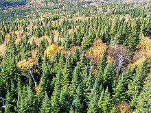
Taiga forest in Gaspé, Québec, Canada

Given the geology of the province and its different climates, there is an established number of large areas of vegetation in Quebec. These areas, listed in order from the northernmost to the southernmost are: the tundra, the taiga, the Canadian boreal forest (coniferous), mixed forest and Deciduous forest. [11]

On the edge of the Ungava Bay and Hudson Strait is the tundra, whose flora is limited to a low vegetation of lichen with only less than 50 growing days a year. The tundra vegetation survives an average annual temperature of −8 °C (18 °F). The tundra covers more than 24% of the area of Quebec. [11] Further south, the climate is conducive to the growth of the Canadian boreal forest, bounded on the north by the taiga.

Different forest areas of Quebec Ecoregions quebec map.svg
Different forest areas of Quebec

Not as arid as the tundra, the taiga is associated with the sub-Arctic regions of the Canadian Shield [68] and is characterized by a greater number of both plant (600) and animal (206) species, many of which live there all year. The taiga covers about 20% of the total area of Quebec. [11] The Canadian boreal forest is the northernmost and most abundant of the three forest areas in Quebec that straddle the Canadian Shield and the upper lowlands of the province. Given a warmer climate, the diversity of organisms is also higher, since there are about 850 plant species and 280 vertebrates species. The Canadian boreal forest covers 27% of the area of Quebec. [11] The mixed forest is a transition zone between the Canadian boreal forest and deciduous forest. By virtue of its transient nature, this area contains a diversity of habitats resulting in large numbers of plant (1000) and vertebrates (350) species, despite relatively cool temperatures. The ecozone mixed forest covers 11.5% of the area of Quebec and is characteristic of the Laurentians, the Appalachians and the eastern lowlands forests. [68] The third most northern forest area is characterized by deciduous forests. Because of its climate (average annual temperature of 7 °C [45 °F]), it is in this area that one finds the greatest diversity of species, including more than 1600 vascular plants and 440 vertebrates. Its relatively long growing season lasts almost 200 days and its fertile soils make it the centre of agricultural activity and therefore of urbanization of Quebec. Most of Quebec's population lives in this area of vegetation, almost entirely along the banks of the Saint Lawrence. Deciduous forests cover approximately 6.6% of the area of Quebec. [11]

The total forest area of Quebec is estimated at 750,300 km2 (289,700 sq mi). [69] From the Abitibi-Témiscamingue to the North Shore, the forest is composed primarily of conifers such as the balsam fir, the jack pine, the white spruce, the black spruce and the tamarack. Some species of deciduous trees such as the yellow birch appear when the river is approached in the south. The deciduous forest of the Great Lakes–St. Lawrence Lowlands is mostly composed of deciduous species such as the sugar maple, the red maple, the white ash, the American beech, the butternut (white walnut), the American elm, the basswood, the bitternut hickory and the northern red oak as well as some conifers such as the eastern white pine and the northern whitecedar. The distribution areas of the paper birch, the trembling aspen and the mountain ash cover more than half of Quebec territory. [70]

See also

Related Research Articles

<span class="mw-page-title-main">Geography of Canada</span>

Canada has a vast geography that occupies much of the continent of North America, sharing a land border with the contiguous United States to the south and the U.S. state of Alaska to the northwest. Canada stretches from the Atlantic Ocean in the east to the Pacific Ocean in the west; to the north lies the Arctic Ocean. Greenland is to the northeast with a shared border on Hans Island. To the southeast Canada shares a maritime boundary with France's overseas collectivity of Saint Pierre and Miquelon, the last vestige of New France. By total area, Canada is the second-largest country in the world, after Russia. By land area alone, however, Canada ranks fourth, the difference being due to it having the world's largest proportion of fresh water lakes. Of Canada's thirteen provinces and territories, only two are landlocked while the other eleven all directly border one of three oceans.

<span class="mw-page-title-main">Labrador Peninsula</span> Large peninsula in eastern Canada

The Labrador Peninsula, also known as the Quebec-Labrador Peninsula, is a large peninsula in eastern Canada. It is bounded by Hudson Bay to the west, the Hudson Strait to the north, the Labrador Sea to the east, and the Gulf of Saint Lawrence to the southeast. The peninsula includes the region of Labrador, which is part of the province of Newfoundland and Labrador, and the regions of Saguenay–Lac-Saint-Jean, Côte-Nord, and Nord-du-Québec, which are in the province of Quebec. It has an area of 1,400,000 km2 (541,000 sq mi).

<span class="mw-page-title-main">Saguenay, Quebec</span> Canadian city, settled 1840s

Saguenay is a city in the Saguenay–Lac-Saint-Jean region of Quebec, Canada, on the Saguenay River, about 200 kilometres (120 mi) north of Quebec City by overland route. It is about 126 kilometres (78 mi) upriver and northwest of Tadoussac, located at the confluence with the St. Lawrence River. It was formed in 2002 by merging the cities of Chicoutimi and Jonquière and the town of La Baie. Chicoutimi was founded by French colonists in 1676. As of July 2021, the city had a population of 145,000 and the metropolitan area had a population of 165,000.

<span class="mw-page-title-main">Nunavik</span> Proposed autonomous area in Quebec, Canada

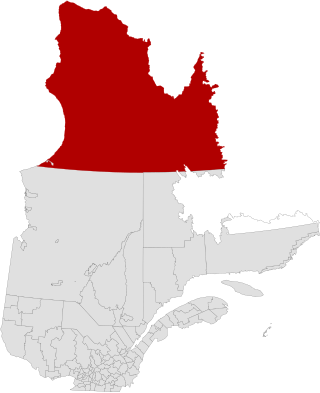
Nunavik is an area in Canada which comprises the northern third of the province of Quebec, part of the Nord-du-Québec region and nearly coterminous with Kativik. Covering a land area of 443,684.71 km2 (171,307.62 sq mi) north of the 55th parallel, it is the homeland of the Inuit of Quebec and part of the wider Inuit Nunangat. Almost all of the 14,045 inhabitants of the region, of whom 90% are Inuit, live in fourteen northern villages on the coast of Nunavik and in the Cree reserved land (TC) of Whapmagoostui, near the northern village of Kuujjuarapik.

<span class="mw-page-title-main">Nord-du-Québec</span> Place in Quebec, Canada

Nord-du-Québec is the largest, but the least populous, of the seventeen administrative regions of Quebec, Canada. With nearly 750,000 square kilometres (290,000 sq mi) of land area, and very extensive lakes and rivers, it covers much of the Labrador Peninsula and about 55% of the total land surface area of Quebec, while containing a little more than 0.5% of the population.

<span class="mw-page-title-main">Sept-Îles, Quebec</span> City in Quebec, Canada

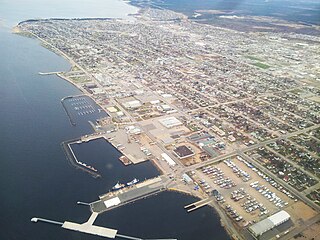
Sept-Îles is a city in the Côte-Nord region of eastern Quebec. It is among the northernmost locales with a paved connection to the rest of Quebec's road network. The population was 25,686 as of the 2011 Canadian census. The town is called Uashat, meaning "bay" in Innu-aimun.

<span class="mw-page-title-main">Geography of Alberta</span>

Alberta is one of the thirteen provinces and territories of Canada. Located in Western Canada, the province has an area of 661,190 km2 (255,290 sq mi) and is bounded to the south by the United States state of Montana along 49° north for 298 km (185 mi); to the east at 110° west by the province of Saskatchewan for 1,223 km (760 mi); and at 60° north the Northwest Territories for 644 km (400 mi). The southern half of the province borders British Columbia along the Continental Divide of the Americas on the peaks of the Rocky Mountains, while the northern half borders British Columbia along the 120th meridian west. Along with Saskatchewan it is one of only two landlocked provinces or territories.

<span class="mw-page-title-main">Central Canada</span> Region of Eastern Canada

Central Canada is a Canadian region consisting of Ontario and Quebec, the largest and most populous provinces of the country. Geographically, they are not at the centre of Canada but instead overlap with Eastern Canada toward the east. Because of their large populations, Ontario and Quebec have traditionally held a significant amount of political power in Canada, leading to some amount of resentment from other regions of the country. Before Confederation, the term "Canada" specifically referred to Central Canada. Today, the term "Central Canada" is less often used than the names of the individual provinces.

<span class="mw-page-title-main">Ungava Peninsula</span> Region in Nunavik, Quebec

The Ungava Peninsula is the far northwestern part of the Labrador Peninsula of the province of Quebec, Canada. Bounded by Hudson Bay to the west, Hudson Strait to the north, and Ungava Bay to the east, it covers about 252,000 square kilometres (97,000 sq mi). Its northernmost point is Cape Wolstenholme, which is also the northernmost point of Quebec. The peninsula is also part of the Canadian Shield, and consists entirely of treeless tundra dissected by large numbers of rivers and glacial lakes, flowing generally east–west in a parallel fashion. The peninsula was not deglaciated until 6,500 years ago and is believed to have been the prehistoric centre from which the vast Laurentide Ice Sheet spread over most of North America during the last glacial epoch.

<span class="mw-page-title-main">Leaf River (Quebec)</span> River in Quebec, Canada

Leaf River is a river in northern Quebec, Canada, at the northern limit of the tree line. It flows from Lake Minto northeast through the Ungava Peninsula into Leaf Bay off Ungava Bay over a distance of 480 kilometres (300 mi). At the head of Leaf Bay is the Inuit community of Tasiujaq.

<span class="mw-page-title-main">Kuujjuaq</span> Northern village municipality in Quebec, Canada

Kuujjuaq, formerly known as Fort Chimo and by other names, is a former Hudson's Bay Company outpost at the mouth of the Koksoak River on Ungava Bay that has become the largest northern village in the Nunavik region of Quebec, Canada. It is the administrative capital of the Kativik Regional Government. Its population was 2,668 as of the 2021 census.

<span class="mw-page-title-main">District of Ungava</span>

The District of Ungava was a regional administrative district of Canada's Northwest Territories from 1895 to 1920, although it effectively ceased operation in 1912. It covered the northern portion of what is today Quebec, the interior of Labrador, and the offshore islands to the west and north of Quebec, which are now part of Nunavut.

<span class="mw-page-title-main">Blanc-Sablon</span> Municipality in Quebec, Canada

Blanc-Sablon is the easternmost community in Le Golfe-du-Saint-Laurent Regional County Municipality, in the administrative region of Côte-Nord, in the province of Quebec, Canada. With a population of 1,122 inhabitants in 2021, it is the most populous community in the county municipality.

The Canadian territory of Nunavut covers about 1.9 million square kilometres of land and water including part of the mainland, most of the Arctic islands, and all of the islands in Hudson Bay, James Bay, and Ungava Bay which belonged to the Northwest Territories. This makes it the fifth largest country subdivision in the world. If Nunavut were a country, it would rank 13th in area, after the Democratic Republic of the Congo. Nunavut has land borders with Manitoba, the Northwest Territories on several islands as well as the mainland, and a tiny land border with Newfoundland and Labrador on Killiniq Island.

<span class="mw-page-title-main">Geography of Ontario</span>

Ontario is located in East/Central Canada. It is Canada's second largest province by land area. Its physical features vary greatly from the Mixedwood Plains in the southeast to the boreal forests and tundra in the north. Ontario borders Manitoba to the west, Hudson Bay and James Bay to the north, Quebec to the east, and the Great Lakes and the United States to the south. The province is named for Great Lake Ontario, an adaptation of the Iroquois word Onitariio, meaning "beautiful lake", or Kanadario, variously translated as "beautiful water". There are approximately 250,000 lakes and over 100,000 kilometres (62,000 mi) of rivers in the province.

<span class="mw-page-title-main">Northwest Atlantic Marine Ecozone</span> Canadian marine ecozone

The Northwest Atlantic Marine Ecozone, as defined by the Commission for Environmental Cooperation (CEC), is a Canadian marine ecozone forming a transitional region between the cold northern waters of the Arctic Ocean and the more temperate waters in its southern extent.

Montreal is the second largest city in Canada and the largest city in the province of Quebec, located along the Saint Lawrence River at its junction with the Ottawa River. The city is geographically constrained, with the majority on the Island of Montreal in the Hochelaga Archipelago, and has several prominent features, including the eponymous Mount Royal. The region experiences four distinct seasons and is classified as a humid continental climate, with very cold and snowy winters and warm and humid summers.

<span class="mw-page-title-main">George River (Quebec)</span> River in Quebec, Canada.

George River, formerly the East or George's River, is a river in northeastern Quebec, Canada, that flows from Lake Jannière mainly north to Ungava Bay.

<span class="mw-page-title-main">Natashquan</span> Municipality in Quebec, Canada

Natashquan is a municipality in Minganie Regional County Municipality, Côte-Nord region, Quebec, Canada. It should not be confused with the adjacent but separate Innu reserve of Nutashkuan.

References

  1. Institut de la statistique du Québec. "Comparaison entre la superficie du Québec et celle de divers pays" [Comparison between the area of Quebec and various countries] (in French). Government of Quebec. Archived from the original on August 8, 2011. Retrieved July 4, 2011.
  2. 1 2 Elson, J. A. "St Lawrence Lowland". Canadian Encyclopedia. Historica Foundation. Archived from the original on October 26, 2007. Retrieved April 28, 2008.
  3. Levinson-King, Robin; Murphy, Jessica (April 9, 2017). "Quebec's maple syrup producers seeking global domination". BBC News. Archived from the original on June 6, 2017.
  4. 1 2 Ressources Naturelles et Faune - Québec. "Québec's Borders". Highlights on the territory - Québec's Borders. Government of Quebec. Archived from the original on August 27, 2011. Retrieved June 21, 2011.
  5. VAILLANCOURT, Jacques (May 6, 2009). "Labrador is no longer part of Quebec, Explanations on the situation" (in French). Vigile.net. Retrieved June 25, 2011.
  6. Canadian Intergovernmental Affairs Secretariat (October 31, 2001). "The Minister of Natural Resources of Quebec and Minister for Canadian Intergovernmental Affairs express Quebec's position in relation to the constitutional changes in the designation of Newfoundland". Government of Quebec. Archived from the original on April 28, 2005. Retrieved December 10, 2009.
  7. "Mont D'Iberville, Québec/Newfoundland". PeakBagger. November 1, 2004. Archived from the original on August 7, 2011. Retrieved July 14, 2011.
  8. Parks Canada (May 2, 2008). "Mingan Archipelago National Park Reserve of Canada". Government of Canada. Archived from the original on November 20, 2007. Retrieved May 15, 2008.
  9. Natural Resources Canada (October 25, 2006). "Borderlands / St. Lawrence Lowlands". The Atlas of Canada. Government of Canada. Archived from the original on January 5, 2008. Retrieved April 28, 2008.
  10. Lasalle, Pierre; Robert J. Rogerson. "Champlain Sea". The Canadian Encyclopedia. Historica Foundation. Archived from the original on December 9, 2007. Retrieved April 28, 2008.
  11. 1 2 3 4 5 6 "Natural History of Quebec". A description of the natural history of the province. McGill University. Archived from the original on July 6, 2011. Retrieved June 22, 2011.
  12. 1 2 3 Ministry of Environment of Quebec 2002, p. 5.
  13. Babin 1986, p. 39.
  14. Boyer, Marcel (January 12, 2008). "11 idées pour changer le Québec". Le Journal de Montréal (in French). Archived from the original on March 25, 2012. Retrieved July 11, 2011.
  15. Commission de toponymie du Québec. "Réservoir de Caniapiscau" (in French). Government of Quebec. Archived from the original on September 20, 2011. Retrieved July 10, 2010.
  16. "Saguenay-St. Lawrence National Park". Digital Wizards (Ontario) Inc. Archived from the original on July 11, 2011. Retrieved July 11, 2011.
  17. 1 2 3 4 5 6 "Climat au Québec" (in French). Government of Quebec. Archived from the original on December 12, 2019. Retrieved December 12, 2019.
  18. Johnabbott Faculty. "Köppen Climate world map" (PDF). johnabbott.qc.ca. Archived from the original (PDF) on September 30, 2011. Retrieved July 13, 2011.
  19. Climat-Québec. "Climate Normals, tabular, year". Government of Canada. Archived from the original on August 27, 2011. Retrieved July 13, 2011.
  20. Climat-Québec. "Tornadoes". Government of Canada. Archived from the original on August 27, 2011. Retrieved July 13, 2011.
  21. Climat-Québec. "Climate Normals, tabular, season". Government of Canada. Archived from the original on August 27, 2011. Retrieved July 13, 2011.
  22. "Sunrise, Sunset, Length of Daytime". time.unitarium.com. Archived from the original on June 14, 2016.
  23. Quebec Portal (October 12, 2006). "Zones climatiques du Québec". Government of Quebec. Archived from the original on August 6, 2011. Retrieved January 23, 2010.
  24. Immigration Québec. "Moyenne mensuelle des températures de Québec (ville) et Montréal". Government of Quebec. Archived from the original on March 25, 2014. Retrieved June 2, 2011.
  25. 1 2 Climat-Québec (August 30, 2010). "Climate Normals, Tabular". Government of Canada. Archived from the original on August 27, 2011. Retrieved July 12, 2011.
  26. "Normales climatiques du Québec 1981-2010" (in French). Government of Quebec. Archived from the original on December 12, 2019. Retrieved December 12, 2019.
  27. Environment Canada (December 29, 2008). "Canada's Top Ten Weather Stories for 2008". Government of Canada. Archived from the original on August 7, 2011. Retrieved July 13, 2011.
  28. Société Radio-Canada. "Records de neige". Canadian Broadcasting Corporation CBC (Radio-Canada SRC). Archived from the original on April 18, 2014. Retrieved January 23, 2010.
  29. Radio-Canada avec Agence France Presse (March 19, 2010). "Climat : L'hiver le plus chaud de l'histoire du pays" (in French). Canadian Broadcasting Corporation CBC (Radio-Canada SRC). Archived from the original on April 3, 2010. Retrieved April 3, 2010.
  30. "National Climate Data and Information Archive". Environment Canada. Archived from the original on July 9, 2013. Retrieved October 24, 2015.
  31. "Montreal/Pierre Elliott Trudeau International Airport". Canadian Climate Normals 1981–2010. October 31, 2011. Archived from the original on October 26, 2014. Retrieved February 24, 2014.
  32. "Daily Data Report for March 2012". Canadian Climate Data. October 31, 2011. Archived from the original on September 11, 2016. Retrieved June 12, 2016.
  33. "Daily Data Report for May 2020". Canadian Climate Data. October 31, 2011. Archived from the original on May 13, 2022. Retrieved May 13, 2022.
  34. "Daily Data Report for November 2022". Canadian Climate Data. October 31, 2011. Retrieved November 7, 2022.
  35. " "Hourly Data Report for November 5, 2022". Canadian Climate Data. October 31, 2011. Retrieved November 7, 2022.
  36. "Montreal, Canada - Detailed climate information and monthly weather forecast". Weather Atlas. Yu Media Group. Archived from the original on July 6, 2019. Retrieved July 6, 2019.
  37. "Quebec/Jean Lesage INT'L A, Quebec". Canadian Climate Normals 1981–2010. Environment and Climate Change Canada. Archived from the original on 9 May 2014. Retrieved 8 May 2014.
  38. "QUEBEC/JEAN LESAGE INTL". Canadian Climate Data. Environment and Climate Change Canada. Archived from the original on 17 August 2016. Retrieved 28 March 2016.
  39. "Quebec". Canadian Climate Data. Environment and Climate Change Canada. Archived from the original on 17 August 2016. Retrieved 28 March 2016.
  40. Yu Media Group d.o.o. "Quebec city, Canada – Detailed climate information and monthly weather forecast". Weather Atlas. Archived from the original on 6 July 2019. Retrieved 6 July 2019.
  41. "Trois-Rivières". Canadian Climate Normals 1981–2010. Environment and Climate Change Canada. 31 October 2011. Retrieved May 12, 2014.
  42. "Cap De La Madeleine". Canadian Climate Data. Environment and Climate Change Canada. 31 October 2011. Retrieved 11 January 2017.
  43. "Trois Rivieres". Canadian Climate Data. Environment and Climate Change Canada. 31 October 2011. Retrieved 11 January 2017.
  44. "Daily Data Report for December 2015". Canadian Climate Data. Environment and Climate Change Canada. 31 October 2011. Retrieved 11 January 2017.
  45. "Nicolet". Canadian Climate Normals 1981–2010. Environment and Climate Change Canada. Retrieved 11 January 2017.
  46. "Baie-Comeau A". Canadian Climate Normals 1981–2010. Environment and Climate Change Canada. 25 September 2013. Retrieved January 17, 2022.
  47. "Sept-Îles A, Quebec". Canadian Climate Normals 1981–2010. Environment and Climate Change Canada . Retrieved November 25, 2013.
  48. "March 2012". Canadian Climate Data. Environment and Climate Change Canada. 31 October 2011. Retrieved 22 June 2016.
  49. "June 2020". Canadian Climate Data. Environment and Climate Change Canada. 31 October 2011. Retrieved 13 May 2022.
  50. Climate Normals for Sept-Îles 1961-1990 , Accessed March 10, 2012.
  51. "Clarke City". Canadian Climate Data. Environment and Climate Change Canada. 31 October 2011. Retrieved 22 June 2016.
  52. "Canadian Climate Normals 1981-2010 Station Data". Environment and Climate Change Canada. Retrieved March 6, 2022.
  53. "Kuujjuaq (Composite Station Threads)". Canadian Climate Normals 1991-2020 Data. Environment and Climate Change Canada. Archived from the original on 26 December 2023. Retrieved 26 December 2023.
  54. "Kuujjuaq Airport". Canadian Climate Normals 1981–2010. Environment and Climate Change Canada. Archived from the original on 26 December 2023. Retrieved November 25, 2019.
  55. "July 2023". Environment and Climate Change Canada. Climate ID: 7113535. Archived from the original on 26 December 2023. Retrieved July 5, 2023.
  56. "Canadian Climate Normals 1951–1980 Volume 8: Atmospheric, Pressure, Temperature and Humidity" (PDF). Environment Canada. Archived from the original (PDF) on 2023-08-09. Retrieved August 11, 2023.
  57. C. Michael Hogan. 2008. Wild turkey: Meleagris gallopavo, GlobalTwitcher.com, ed. N. Stromberg Archived 2017-07-25 at the Wayback Machine
  58. Environnement Canada. "La biodiversité du Saint-Laurent" (in French). Government of Canada. Archived from the original on August 7, 2011. Retrieved July 12, 2011.
  59. Ministère des Ressources naturelles et de la Faune. "Espèces fauniques du Nunavik" (in French). Government of Quebec. Archived from the original on July 6, 2011. Retrieved July 12, 2011.
  60. Ministère des Ressources naturelles et de la Faune. "Poissons du Québec" (in French). Government of Quebec. Archived from the original on July 6, 2011. Retrieved July 12, 2011.
  61. Brûlotte 2009.
  62. Lepage, Denis. "List of Quebec birds" (in French). Les Oiseaux du Québec. Archived from the original on July 16, 2011. Retrieved June 24, 2011.
  63. Les Publications du Québec: Éditeur officiel du Québec (June 1, 2011). "Loi sur les races animales du patrimoine agricole du Québec (L.R.Q., c. R-0.01)" (in French). Government of Quebec. Archived from the original on April 23, 2008. Retrieved July 12, 2011.
  64. Conseil des appellations réservées et des termes valorisants. "Register of Quebec Recognized Reserved Designations". Ministère de l'Agriculture, des Pêcheries et de l'Alimentation du Québec. Archived from the original on January 30, 2012. Retrieved July 14, 2011.
  65. "Animal Welfare". Fédération des producteurs de porcs du Québec. Archived from the original on January 25, 2012. Retrieved July 12, 2011.
  66. "Fédération des producteurs d'agneaux et moutons du Québec". Agneauduquebec.com. Archived from the original on February 23, 2011. Retrieved June 25, 2011.
  67. CDPNQ (September 23, 2010). "Le Centre de données sur le patrimoine naturel du Québec (CDPNQ)". Government of Quebec. Archived from the original on April 9, 2011. Retrieved July 14, 2011.
  68. 1 2 "Types de végétations du Québec". Types of vegetation and climatic zones of Quebec (in French). Government of Quebec. Archived from the original on August 27, 2011. Retrieved June 22, 2011.
  69. Ministère des Ressources naturelles et de la Faune. "Domaine forestier" (in French). Government of Quebec. Archived from the original on April 6, 2012. Retrieved August 19, 2007.
  70. Arboquebecium. "L'Arboretum du Québec" (in French). Arboquebecium.com. Archived from the original on July 7, 2011. Retrieved June 25, 2011.

Works cited